伏牛山区迎河小流域不同土地利用类型的土壤粒径分布特征
2017-07-05方肖晨王春红张荣华张光灿邢先双杨锐赵洁
方肖晨,王春红,张荣华,张光灿†,邢先双,杨锐,赵洁
(1.山东省土壤侵蚀与生态修复重点实验室/山东农业大学林学院,271018,山东泰安;2.水利部水利水电规划设计总院,100120,北京;3.山东省水文局,250012,济南)
伏牛山区迎河小流域不同土地利用类型的土壤粒径分布特征
方肖晨1,王春红2,张荣华1,张光灿1†,邢先双3,杨锐1,赵洁1
(1.山东省土壤侵蚀与生态修复重点实验室/山东农业大学林学院,271018,山东泰安;2.水利部水利水电规划设计总院,100120,北京;3.山东省水文局,250012,济南)
为探讨伏牛山区坡耕地土壤物理性能的退化特征,在河南省鲁山县迎河小流域,利用激光粒度仪和土壤分形模型,比较分析了4种土地利用类型的土壤粒径分布(PSD)及其分形特征。研究结果表明:1)土壤PSD简单分维(Dv)以乔木林地最高(2.658),坡耕地最低(2.489),多重分维(容量维D0、信息维D1、关联维D2)以乔木林地最高(0.941、0.926、0.91),坡耕地最低(0.927、0.899、0.849)。不同分形参数均表现为:坡耕地<灌草坡地和水平梯田<乔木林地;2)土壤PSD的Dv、D0、D1和D2,与黏粒和粉粒体积分数显著正相关,与砂粒体积分数显著负相关。因此,利用土壤PSD简单分形和多重分形维数,可量化表征土壤质地的粗细程度和非均匀性质的差别;坡耕地土壤质地的粗粒化程度和非均匀性明显大于其他土地利用类型;土壤细粒(黏粒和粉粒)物质流失是坡耕地土壤质地粗粒化和非均匀程度增大的重要原因。
土壤颗粒分布; 分形维数; 多重分形; 土地利用类型; 迎河小流域
伏牛山区属于全国水土保持区划的“土壤保持-水源涵养功能区”[1],是淮河流域乃至北方土石山区土壤侵蚀最为严重的区域之一[2]。土地利用类型是影响土壤侵蚀的重要因素,坡耕地是伏牛山区土壤侵蚀的主要策源地[3],亦是坡面侵蚀程度与危害最大的土地利用类型。坡面侵蚀引发土壤细颗粒物质流失,导致土壤质地粗化和土壤结构与性能的退化[4]。土壤颗粒组成或粒径分布与土壤质地、结构和性能密切相关[5-6],研究不同土地利用类型下的土壤粒径分布特征,对于深入认识坡耕地侵蚀对土壤结构与性能的危害具有重要作用。
目前,分形理论与方法已成为定量化研究土壤粒径分布(particle size distribution,PSD)特征的重要手段。在以往的报道中,多见于利用传统吸管法或比重计法测定土壤颗粒组成[7-8],研究土壤PSD简单分形的质量维数[7-10]。近年来,随着激光衍射法(激光粒度仪)在土壤颗粒组成测定中的应用[7-8,11-12],对土壤PSD多重分形特征的研究报道逐渐增多[13-16]。研究认为,多重分形可对土壤PSD的复杂性和非均匀性给予一定的解释[15]。其中,已有研究报道了不同土地利用类型或植被类型下土壤PSD多重分形维数与非均匀性质的变化[5-6,17-20],但少见有关坡耕地这一土地利用类型的报道。
笔者以伏牛山区迎河小流域内坡耕地、水平梯田、灌草坡地和乔木林地为对象,利用简单分形和多重分形方法,分析不同土地利用类型的土壤PSD特征,以量化坡耕地土壤PSD粗细程度、非均匀性与其他土地利用类型的差别,为定量评价坡耕地土壤物理性状的退化程度提供试验证据。
1 研究区概况
迎河小流域地处河南省鲁山县,位于伏牛山脉东麓外方山余脉、淮河水系沙河上游,地理坐标E 112° 42′49″~112° 44′20″,N 33° 54′16″~33° 56′34″,总面积约5.83 km2。鲁山县属暖温带大陆性季风气候,多年平均年降水量685.4 mm,多年平均年蒸发量965.1 mm,多年平均气温为15.3 ℃,年日照时间1 625.9 h,无霜期245 d。迎河小流域地貌以低山丘陵为主,海拔在224.3~732.5 m之间。母岩主要有石灰岩、风化片麻岩,土壤质地以粉质及砂质壤土为主[2]。
迎河小流域植被类型属于暖温带落叶阔叶林,乔木植物主要有麻栎(Quercusacutissima)、黄连木(Pistaciachinensis)、油桐(Verniciafordii)等,灌木植物主要有荆条(Vitexnegundovar.heterophylla)、胡枝子(Lespedezabicolor)、酸枣(Ziziphusjujubavar.spinosa)、扁担木(Grewiabiloba)等,草本植物主要有苔草(Carextristachya)、白莲蒿(Artemisiasacrorum)、益母草(Leonurusartemisia)、艾蒿(Artemisiaeargyi)、茅叶荩草(Arthraxonlanceolatus)、早熟禾(Poaannua)等。
2 研究方法
2.1 样品采集
在小流域踏查的基础上,选取4种土地利用类型(5种植被类型)为研究对象设置样地(表1),其中乔木林地和灌草坡地处于封禁保育状态。在每种土地利用类型中,设置3个临时样地(20 m×20 m),每个样地内采用5点取样法[17-18]挖取表层(0~20 cm)土壤,带回实验室将同一样地的土壤混合均匀,经风干处理后进行土壤颗粒组成测定。

表1 不同土地利用类型样地概况Tab.1 Structural situation of different land use types in the experimental area
2.2 测试方法
2.2.1 土壤颗粒组成测定 土壤颗粒组成采用激光粒度仪测定。将野外采集的土壤中>2 mm的石砾筛除,测定≤2 mm土粒的颗粒组成。取0.3 g土样加入10%的H2O2溶液去除有机质,之后加入10%的HCl溶液去除碳酸盐。加去离子水并除上清液,反复静置调pH值为6.5~7.0。加入0.1 mL/L的六偏磷酸钠,超声振荡10 min后,使用激光粒度仪(LS13320)测量土壤颗粒(0.02~2 000 μm)体积比例[18]。
2.2.2 简单分形维数计算 根据美国制分级标准[21]将土壤粒径分为7个级别,即黏粒<0.002 mm、粉粒0.002~0.05 mm、极细砂粒0.05~0.1 mm、细砂粒0.1~0.25 mm、中砂粒0.25~0.5 mm、粗砂粒0.5~1.0 mm、极粗砂粒1~2 mm,采用土壤颗粒体积分形模型,计算土壤PSD的简单分形维数(Dv)。具体计算方法详见文献[18]和[22]。
2.2.3 多重分形维数计算 利用广义分形维数谱函数(q-Dq)表述土壤PSD的多重分形特征,将土壤颗粒组成测定的粒径范围(0.02~2 000 μm)划分为64个小区间,利用q-Dq谱函数计算在-10≤q≤10范围内(步长为1)的Dq值,得到土壤PSD的q-Dq关系曲线。其中:当q=0、1、2时,即容量维数D0、信息维数D1和关联维数D2。具体计算方法详见文献[15]和[17-18]
2.3 数据处理
数据处理制图采用Office Excel 2003制作,相关性分析采用SPSS19.0软件,方差分析采用最小显著性差异(LSD)法。
3 结果与讨论
3.1 土壤粒径分布频率特征
土壤粒径分布频率曲线(图1)比较直观地表明,不同土地利用类型的土壤粒径分布(PSD)具有明显差别。在坡耕地中,PSD高峰区出现在粒径为
0.25~1.0 mm的中粗砂粒范围,且明显高于其他粒径的土粒体积分数;在乔木林地中,PSD高峰区出现在粒径为0.002~0.05 mm的粉粒范围,与其他粒径中土粒体积分数的差别相对较小。按美国制土壤质地的粒级分类标准[21]分析,不同土地利用类型土壤颗粒组成表(表2)可得,不同土地利用类型土壤中的黏粒体积分数,以乔木林地的最高(5.98%~7.94%),坡耕地的最低(2.38%),灌草坡地和水平梯田的介于二者之间,乔木林地的2种植被类型分别比坡耕地高151%、234%;而砂粒体积分数以坡耕地的最高(73.94%),乔木林地的最低(35.82%~36.60%),坡耕地分别比乔木林地的2种植被类型高106%、102%。

QM-M:麻栎林,QM-Z:杂木林,GC:灌草坡地,TT:水平梯田,PG:坡耕地. 下同。QM-M:Quercus acutissima forest. QM-Z: Weed tree forest. GC: Shrub-grass land. TT: Terraced land. PG: Sloping farmland. The same below.图1 不同土地利用类型土壤颗粒体积含量频率分布Fig.1 Frequency distribution of volume of soil particles under different land use types

土地利用类型Landusetype植被类型Vegetationtype土壤粒级Soilseparate/mm黏粒Clay粉粒Silt砂粒Sand合计Total极细砂粒Veryfinesand细砂粒Finesand中砂粒Middlesand粗砂粒Coarsesand极粗砂粒Verycoarsesand<00020002~005005~20005~0101~025025~0505~11~2QMQM⁃M749559136607649855901069252QM⁃Z598582035828131090819724136GCGCC57230446384606121916602088811TTNZW296430254028328099291903929PGNZW23823687394516144022162640582平均值Average-45341775370719108814131674476
注:土壤粒级中的相同粒径包含在较大的粒级范围中。如粒径为0.05 mm的土粒包含在0.002~0.05 mm的粒级之中。Note: The same particle size in soil separate is included in larger size range, for instance, soil particle with a diameter of 0.05 mm,is included in the 0.002-0.05 mm soil separate.
不同土地利用类型下的土壤质地属性(表3),乔木林地属于粉壤土,灌草坡地和水平梯田属于砂壤土,坡耕地为壤砂土。以上结果表明,细粒物质(粉、黏粒)体积分数的不同使5种土地利用类型土壤质地表现出差异性,坡耕地与其他土地利用类型相比,其质地粗化最明显。
3.2 土壤粒径分布分形特征
3.2.1 简单分形 土壤PSD简单分形维数可定量化表征土壤颗粒组成的性质,即反映土壤颗粒的大小及其比例关系和土壤质地的粗细程度[5,10]。分形维数由小到大,可表征土壤质地由粗到细或由疏松到紧实变化[12]。由表3可看出,不同土地利用方式下土壤PSD的简单分形维数(体积维数Dv)在2.489~2.658之间,表现为乔木林地(2.658和2.627)>灌草坡地(2.613)>水平梯田(2.540)>坡耕地(2.489),且不同土地利用类型之间Dv大小差异极显著(P<0.01)。
由表4可看出,土壤PSD的Dv与土壤黏粒体积分数呈极显著正相关,与粉粒体积分数显著正相关,与砂粒体积分数显著负相关。综上,土壤PSD的分形维数Dv可量化表征不同土地利用类型土壤质地粗细程度的差别,坡耕地土壤质地的粗粒化程度明显高于灌草坡地、水平梯田和乔木林地。坡耕地中土壤黏粒体积分数较低和砂粒体积分数较高,是土壤Dv较低和粗粒化程度较高的重要原因。
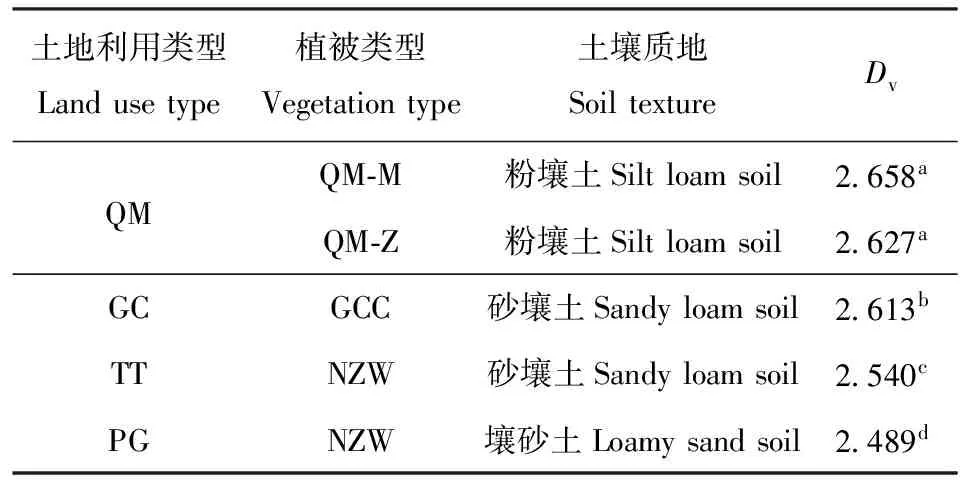
表3 不同土地利用类型土壤质地与PSD简单 分形维数(Dv)Tab.3 Fractal dimension (Dv) and soil texture under different land use types
注:不同小写字母表示不同植被类型间差异极显著(P<0.01)。Note: Different lowercase letters refer to very significant difference among vegetation types atP<0.01.
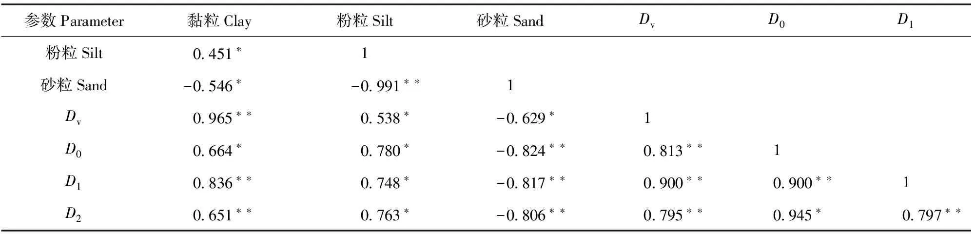
表4 土壤PSD分形维数与土壤颗粒组成相关性分析Tab.4 Correlation analysis between soil particle composition and fractal dimension
注:*表示在0.05水平上显著(P<0.05),**表示在0.01水平上显著(P<0.01)。Note: * refers to significantly different at 0.05 level (P< 0.05), ** refers to significantly different at 0.01 level (P< 0.01).
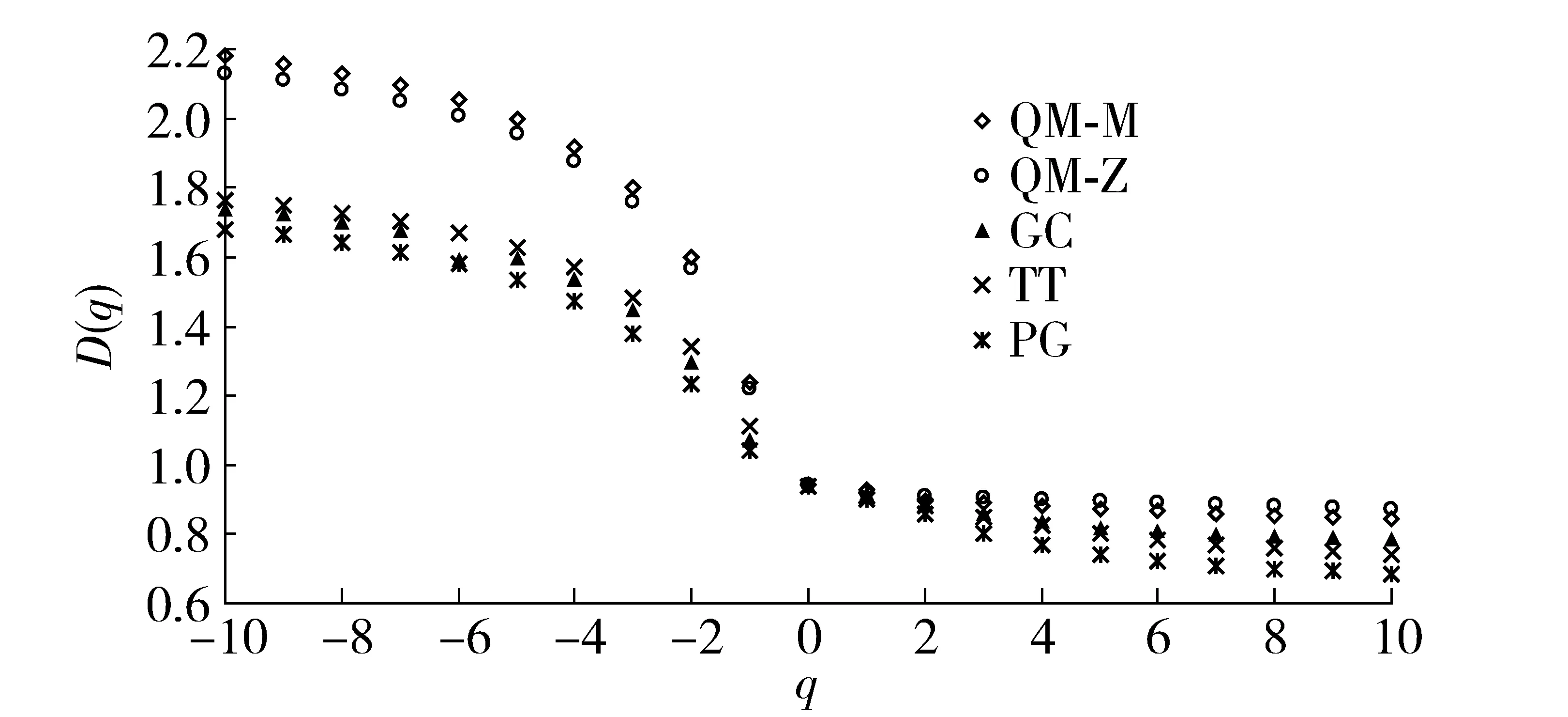
图2 土壤粒径分布的广义分形维数DqFig.2 Multi-fractal spectra Dq of soil particle distributions
3.2.2 多重分形 多重分形的广义维数(Dq,如图2)利用概率密度权重(q)的大小,量化分形测度的统计属性,可从不同局域或层次上量化表征土壤PSD分形结构的复杂程度和非均匀性质[15]。q<0时的Dq突出小概率测度区域的性质,可反映PSD分形结构的复杂或精细特征[17-18],其变化幅度(如D-10-D0值)越大,表征分形结构越精细或越复杂。q>0时的Dq突出大概率测度区域的性质,可反映PSD整体的非均匀性质[13,16,23-24],其变化幅度(如D0-D10值)越大,表征土壤PSD越不均匀。容量维数D0描述PSD整体的基本性质[5,13,15],可反映PSD颗粒群体数目的多少和粒径范围的大小[25];D0越大,表征土壤PSD的颗粒群体数目越多、粒径范围越大或缺失粒径越少。信息维数D1反映PSD测度在局域的集中程度[13-14,18],D1越大,表征PSD测度在局域分布的粒径范围越宽、集中程度越低,土壤PSD越均匀。关联维数D2反映PSD测度在局域间的离散程度[13],D2越大,表征PSD测度在不同局域间分布的差别越小、离散性越大,土壤PSD越均匀。

表5 不同土地利用类型土壤PSD的多重分形特征参数Tab.5 Multi-fractal parameters of soil particle distributions of different land use types
注:不同小写字母表示不同植被类型间差异显著(P<0.05)。Note: Different lowercase letters refer to significant difference among vegetation type (P<0.05).
由图2和表5可看出,在q<0时Dq的变化幅度(D-10-D0)表现出坡耕地(0.757)<灌草坡地和水平梯田(0.801和0.829)<乔木林地(1.192和1.240),这表征坡耕地土壤PSD分形结构的精细或复杂程度明显低于其他土地利用类型。而q>0时Dq的变化幅度(D0-D10)表现出坡耕地(0.209)>水平梯田(0.196)>灌草坡地(0.154)>乔木林地(0.098和0.068),这表征坡耕地土壤PSD整体的均匀性明显低于其他土地利用类型。容量维D0、信息维D1和关联维D2,以坡耕地<灌草坡地和水平梯田<乔木林地(表5),且在不同土地利用方式之间差异显著(P<0.05),这表征坡耕地土壤PSD颗粒群的数量、局域或整体的均匀性显著低于其他土地利用类型。由表4可看出,D0、D1和D2均与土壤黏粒、粉粒体积分数和简单维数Dv显著正相关,与砂粒体积分数显著负相关,其中D1、D2与土壤黏粒、砂粒体积分数相关性极显著。这表明土壤黏粒和砂粒体积分数对PSD均匀性影响较大,黏粒越多或砂粒越少,土壤PSD越均匀。
综上,广义分形维数(Dq)可量化表征不同土地利用类型土壤PSD均匀程度,坡耕地土壤PSD的均匀程度明显低于乔木林地、灌草坡地和水平梯田。土壤黏粒体积分数较低和砂粒体积分数较高,是坡耕地土壤PSD均匀程度较低的重要原因。
4 结论与讨论
本研究表明:土壤PSD的简单分形维数(Dv)和广义分形维数(Dq)可量化表征不同土地利用类型土壤质地粗细程度和非均匀性质的差别。坡耕地土壤质地的粗粒化程度和非均匀性明显高于灌草坡地、水平梯田和乔木林地;坡耕地中土壤细粒(黏粒和粉粒)物质流失是土壤质地粗化和非均匀程度增大的重要原因。
目前,利用土壤PSD简单分形维数定量化表征土壤质地粗细程度方面的研究结果[6-7,11,26-27]比较一致。主要结论为分形维数的大小与土壤黏粒、粉粒体积分数显著正相关,与砂粒体积分数显著负相关;分形维数由小到大,反映了土壤质地由粗到细的变化;与本研究结果(表3、表4)相同。已有研究表明,土壤质地和性能较好时PSD的体积分维(Dv)大约在2.55~2.80之间,如三峡库区耕地壤土的Dv为2.65~2.75[27],江西省林地壤土的Dv为2.70~2.80[7],西安市园地和农田壤土的Dv为2.55~2.75[26]。相比上述结果,本研究区乔木林地、灌草坡地和水平梯田的Dv与其比较接近,坡耕地的Dv明显较低(表3)。也有研究[6,11]报道了沂蒙山区和陕北黄土区坡耕地土壤的Dv和细粒(黏粒、粉粒)体积分数明显小于其他土地利用类型,这与本研究结果一致。
利用广义分形维数(Dq)可对不同土壤PSD的复杂性和非均匀性给予一定的解释[15]。已有研究报道了Dq中D0、D1和D2与土壤颗粒组成的关系[5-6,13-14,16,17-18],但不同研究报道的结果还很不一致。以土壤黏粒体积分数与Dq中D0、D1和D2的关系为例,不同的结果有黏粒体积分数与D0显著正相关[7]或无相关[5,13,17-18],与D1显著正相关[5-6,14,17-18]或负相关[16],与D2显著正相关[5]、负相关[16]或无相关[13],本研究结果为土壤黏粒体积分数与D0、D1、D2均有显著正相关(表4)。不同研究之间结果不一致的原因还需要进一步研究。本研究在一定程度上反映了不同质地土壤(粉壤土、砂壤土、壤砂土)PSD广义维数和非均匀性的差别(表3、图2和表5),但迄今为止,关于土壤质地属性与土壤PSD多重分形及非均匀性关系的报道还较少见,需要开展进一步研究。
[1] 水利部.《全国水土保持区划(试行)》的通知[EB/OL]. [2016-12-22]. https://wenku.baidu.com/view/a7132100763231126edb11e0.html The Ministry of Water Resources of the People′s Republic of China.《Division of soil and water conservation in the whole country (for Trial Implementation)》[EB/OL]. [2016-12-22].https://wenku.baidu.com/view/a7132100763231126edb11e0.html
[2] 徐志强,张光灿,刘霞,等. 淮河流域伏牛山区水土保持生态自然修复适宜性评价与分区[J]. 中国水土保持科学, 2013,11(3):17. XU Zhiqiang, ZHANG Guangcan, LIU Xia, et al. Suitability evaluation and zoning in ecological natural restoration of soil and water conservation in Funiu Mountains Area of Huaihe River Valley[J]. Science of Soil and Water Conservation, 2013, 11(3):17.
[3] 姚孝友,刘霞,张光灿. 淮河流域坡耕地水土流失特点与综合整治模式[J]. 中国水土保持科学,2012,10(1):94. YAO Xiaoyou, LIU Xia, ZHANG Guangcan. Characteristics of soil and water loss and the comprehensive control patterns of slope farmland in Huaihe River Basin[J]. Science of Soil and Water Conservation, 2012, 10(1):94.
[4] 张洪江. 土壤侵蚀原理 [M]. 2版. 北京:中国林业出版社,2008:62. ZHANG Hongjiang. Principle of soil erosion[M]. 2nd ed. Beijng: China Forestry Publishing House, 2008:62.
[5] 白一茹,汪有科. 黄土丘陵区土壤粒径分布单重分形和多重分形特征[J]. 农业机械学报,2012,43(5):43. BAI Yiru, WANG Youke. Monofractal and multifractal analysis on soil particle distribution in hilly and gully areas of the Loess Plateau[J]. Transactions of the Chinese Society for Agricultural Machinery, 2012, 43(5):43.
[6] 董莉丽,郑粉莉. 陕北黄土丘陵沟壑区土壤粒径分形特征[J]. 土壤,2010,42(4):302. DONG Lili,ZHENG Fenli. Fractal characteristics of soil particle size distributions in gully-hilly regions of the loess plateau, north of Shaanxi, China[J]. Soil, 2010,42(4):302.
[7] 杨金玲,李德成,张甘霖,等.土壤颗粒粒径分布质量分形维数和体积分形维数的对比[J].土壤学报,2008,45(3): 413. YANG Jinling,LI Decheng, ZHANG Ganlin,et al. Comparison of mass and volume fractal dimensions of soil particle size distributions[J]. Acta Pedologica Sinica,2008,45(3):413.
[8] 杨艳芳,李德成,杨金玲,等. 激光衍射法和吸管法分析黏性富铁土颗粒粒径分布的比较[J]. 土壤学报, 2008,45(3): 405. YANG Yanfang,LI Decheng,YANG Jinling,et al. Comparison between laser diffraction and pipette methods in analyses of PSD of clayey ferrisol[J]. Acta Pedologica Sinica,2008,45(3):405.
[9] 李德成,张桃林. 中国土壤颗粒组成的分形特征研究[J]. 土壤与环境,2000,9(4):263. LI Decheng, ZHANG Taolin. Fractal features of particle size distribution of soils in china[J]. Soil and Environmental Sciences,2000,9(4):263.
[10] 杨培岭,罗元培,石元春. 用粒径的重量分布表征的土壤分形特征[J]. 科学通报,1993,38(20):1896. YANG Peiling, LUO Yuanpei, SHI Yuanchun. With the particle weight distribution characterization to represent soil fractal characteristics[J]. Chinese Science Bulletin.1993, 38(20):1896.
[11] 徐萍,刘霞,张光灿,等. 鲁中山区小流域不同土地利用类型的土壤分形及水分入渗特征[J]. 中国水土保持科学, 2013,11(5):89. XU Ping,LIU Xia,ZHANG Guangcan,et al. Fractal features and infiltration characteristics of soil of different land uses in a small watershed of Rocky Mountainous Area in the Middle of Shandong Province[J]. Science of Soil and Water Conservation,2013,11(5):89.
[12] 王国梁,周生路,赵其国. 土壤颗粒的体积分形维数及其在土地利用中的应用[J]. 土壤学报,2005,42(4):545. WANG Guoliang, ZHOU Shenglu, ZHAO Qiguo. Volume fractal dimension of soil particles and its applications to land use[J]. Acta Pedologica Sinica, 2005, 42(4):545.
[13] 孙梅,孙楠,黄运湘,等. 长期不同施肥红壤粒径分布的多重分形特征[J]. 中国农业科学,2014,47(11):2173. SUN Mei,SUN Nan,HUANG Yunxiang,et al. Multifractal characterization of soil particle size distribution under long-term different fertilizations in upland red soil[J]. Scientia Agricultura Sinica, 2014, 47(11):2173.
[14] 管孝艳,杨培岭,吕烨. 基于多重分形理论的农田土壤特性空间变异性分析[J]. 应用基础与工程科学学报, 2011,19(5):712. GUAN Xiaoyan,YANG Peiling,LYU Ye,et al. Analysis on spatial variability of soil properties based on multifractal theory[J]. Journal of Basic Science and Engineering, 2011, 19(5):712.
[15] 李敏,李毅. 土壤颗粒数量分布的局部分形及多重分形特性[J]. 西北农林科技大学学报(自然科学版), 2011,39(11): 216. LI Min, LI Yi. Local fractal and multifractal characteristics of soil number-based particle distributions[J]. Journal of Northwest A&F University(Nat. Sci. Ed.),2011,39(11):216.
[16] MIRANDA J G V, MONTEM E, ALVES M C, et al. Multifractal characterization of saprolite particle-size distributions after topsoil removal[J]. Geodermy, 2006, 134(3-4): 373.
[17] 茹豪,张建军,李玉婷,等. 黄土高原土壤粒径分形特征及其对土壤侵蚀的影响[J]. 农业机械学报, 2015,46(4): 176. RU Hao, ZHANG Jianjun, LI Yuting, et al. Fractal features of soil particle size distributions and its effect on soil erosion of Loess Plateau[J]. Transactions of the Chinese Society for Agricultural Machinery, 2015,46(4):176.
[18] 王德,傅伯杰,陈利顶,等. 不同土地类型下土壤颗粒分形分析:以黄土丘陵沟壑区为例[J]. 生态学报, 2007,27(7): 3081. WANG De,FU Bojie,CHEN Liding,et al. Fractal analysis on soil particle size distributions under different land-use types: a case study in the loess hilly areas of the Loess Plateau China[J]. Acta Ecologica Sinica, 2007, 27(7):3081.
[19] 董莉丽,马孝燕,胡丹,等. 吴起县退耕还林样地土壤粒径分布的单一和多重分形特征[J]. 干旱区资源与环境, 2015,29(7): 111. DONG Lili,MA Xiaoyan,HU dan,et al. Monofractal and multifractal characteristics of soil particle size distribution in sample sites of Grain for Green in Wuqi County[J]. Journal of Arid Land Resources and Environment, 2015, 29(7): 111.
[20] WANG De, FU Bojie, ZHAO Wenwu, et al. Multifractal characteristics of soil particle size distribution under different land-use types on the Loess Plateau, China[J]. Catena, 2008, 72(1): 29.
[21] 黄昌勇. 土壤学[M]. 北京:中国农业出版社,2004:69. HUANG Changyong. Soil science[M]. Beijing: China Agriculture Press, 2004:69.
[22] 刘霞,姚孝友,张光灿,等. 沂蒙山林区不同植物群落下土壤颗粒分形与孔隙结构特征[J]. 林业科学, 2011,47(8): 32. LIU Xia, YAO Xiaoyou, ZHANG Guangcan, et al. Fractal features of soil particle size distribution and characteristics of soil pore space under different plant communities in forests of Yimeng mountains[J]. Scientia Silvae Sinicae, 2011,47(8): 32.
[23] GROUT H, TARQUIS A, WIESNER M R. Multifractal analysis of particle size distributions in soil[J]. Environment Science Technology, 1998, 32: 1176.
[24] 王金满,张萌,白中科,等. 黄土区露天煤矿排土场重构土壤颗粒组成的多重分形特征[J]. 农业工程学报,2014, 30(4):230. WANG Jinman,ZHANG Meng,BAI Zhongke,et al. Multi-fractal characteristics of reconstructed soil particle in opencast coal mine dump in loess area[J]. Transactions of the Chinese Society of Agricultural Engineering, 2014, 30(4): 230.
[25] 韦伟,杜茂安,朱佳,等. 絮凝过程中絮体生长的多重分形行为[J]. 环境科学学报,2014,34(1):79. WEI Wei,DU Maoan,ZHU Jia,et al. Multifractal behavior of flocs growth in flocculation processes[J]. Acta Scientiae Circumstantiae, 2014, 34(1):79.
[26] 淮态,庞奖励,文青,等. 不同土地利用方式下土壤粒径分布的分维特征[J]. 生态与农村环境学报,2008,24(2):41. HUAI Tai, PANG Jiangli, WEN Qing,et al. Fractal characteristics of particle size distribution in soils different in land Use[J]. Journal of Ecology and Rural Environment, 2008, 24(2):41.
[27] 韦杰,鲍玉海,金慧芳,等. 三峡库区坡耕地有限顺坡耕作模式及减蚀效应[J]. 灌溉排水学报,2014,31(6):45. WEI Jie,BAO Yuhai,JIN Huifang,et al. A downslope tillage system with limited slopelength on sloping farmlands in the three gorges area and its erosion reduction effects[J]. Journal of Irrigation and Drainage,2014,31(6):45.
Soil particle size distribution characteristics under different land usetypes in Yinghe Watershed of Funiu Mountain Area
FANG Xiaochen1, WANG Chunhong2, ZHANG Ronghua1, ZHANG Guangcan1, XING Xianshuang3,YANG Rui1, ZHAO Jie1
(1.The Key Laboratory of Soil Erosion and Ecological Restoration of Shandong Province, College of Forestry, Shandong Agricultural University,271018, Tai′an, Shandong, China;2.Water Resources and Hydropower Planning and Design General Institute,Ministry of Water Resources, 100120, Beijing, China;3. Hydrographic Office of Shandong Province, 250002, Jinan, China)
[Background] The soil erosion of Funiu Mountain Area has been one of the most serious problems in Huaihe River Basin even rocky mountain areas of northern China. Sloping farmland is the main source of soil erosion which causes loss of fine particle, degradation of the soil structure and performance. The soil fractal theory has been an important method to quantify particle size distribution (PSD). In this paper, we explore the degradation degree of sloping farmland soil physical property with fractal theory in Funiu Mountain Area in Yinghe Watershed, Lushan County of Henan Province. [Methods] On the basis of small watershed investigation, we selected four land use types (five vegetation types) as research subjects and set sample plots. In every land use type plot, three temporary sample plots (20 m×20 m) were set to dig surface soil (0-20 cm) with 5-point sampling method. The soil from the same plot was well mixed to dry for the determination of particle size distribution. After the determination by the laser granulometer, the frequency distribution of volume of the soil particle (< 2 mm) under different land use types was obtained. Then we divided the volume of soil particle into 7 levels according to American standard: clay: <0.002 mm, silt: 0.002-0.05 mm, very fine sand: 0.05-0.1 mm, fine sand: 0.1-0.25 mm, middle sand: 0.25-0.5 mm, coarse sand: 0.5-1.0 mm, very coarse sand: 1-2 mm. By soil particle volume fractal model and general dimension spectrum, the fractal dimensionDvand multi-fractal parameterDqwere obtained. Among them, whenq= 0, 1, 2, theDqis respectivelyD0,D1,D2. After the above method and comprehensive analysis, we studied the composition of soil particles size, variation of fractal dimension characteristic parameter and effect on PSD uniformity under four land use types. [Results] 1) TheDvwas manifested as: the maximum was arbor forest (2.658), and the sloping farmland was the smallest one by 2.489. The multi-fractal parameters (D0,D1,D2) was manifested as: the maximum was arbor forest (0.941, 0.926, 0.91), and the sloping farmland was the smallest one by 0.927, 0.899, 0.849. All the fractal parameters were manifested as: sloping farmland < shrub-grass slope land and terraced land < arbor forest. 2) There were significant positive correlation betweenDv,D0,D1,D2and clay, silt volume fraction, and all of them had significantly negative correlations with sand volume fraction. [Conclusions] Soil fractal theory and multi-fractal theory can be used to quantitatively characterize differences of soil texture granularity distribution and heterogeneity; the coarse graining and heterogeneity of sloping farmland is higher than other land use types, the loss of soil fine particle (clay and silt) lead to the increase of degree of coarse graining and heterogeneity of sloping farmland.
soil particle size distribution; fractal dimension; multi-fractal; land use type; Yinghe Watershed
2016-12-28
2016-04-24
方肖晨(1990—),男,硕士研究生。主要研究方向:植被重建与水文生态。E-mail:leomld@163.com
†通信作者简介: 张光灿(1963—),男,博士,教授,博士生导师。主要研究方向:林业生态工程,植物水文生态。E-mail:zhgc@sdau.edu.cn
S157
A
2096-2673(2017)03-0009-08
10.16843/j.sswc.2017.03.002
项目名称: 淮河水利委员会水土保持管理项目“淮河流域国家水土保持重点工程区水土流失存在问题及防治对策”(HWSBC2015002)
