The simulation of LUCC based on Logistic-CA-Markov model in Qilian Mountain area, China
2016-10-12HaiJunWangXiangDongKongBoZhang
HaiJun Wang, XiangDong Kong Bo Zhang
1. Engineering & Technical College of Chengdu University of Technology, Leshan, Sichuan 614007, China
2. The College of Geography and Environmental Science, Northwest Normal University, Lanzhou, Gansu 730070, China
The simulation of LUCC based on Logistic-CA-Markov model in Qilian Mountain area, China
HaiJun Wang1,2*, XiangDong Kong1, Bo Zhang2
1. Engineering & Technical College of Chengdu University of Technology, Leshan, Sichuan 614007, China
2. The College of Geography and Environmental Science, Northwest Normal University, Lanzhou, Gansu 730070, China
ABSTRACT
The Qilian mountain area was examined for using the Logistic-CA-Markov coupling model combined with GIS spatial analyst technology to research the transformation of LUCC, driving force system and simulate future tendency of variation. Results show that: (1) Woodland area decreased by 12.55%, while grassland, cultivated land, and settlement areas increased by 0.22%, 7.92%, and 0.03%, respectively, from 1986 to 2014. During the period of 1986 to 2000, forest degradation in the middle section of the mountain area decreased by 1,501.69 km2. Vegetation cover area improved, with a net increase of grassland area of 38.12 km2from 2000 to 2014. (2) For constructing the system driving force, the best simulation scale was 210m×210m. Based on logistic regression analysis, the contribution (weight) of composite driving forces to land use and cover change was obtained, and the weight value was more objectively compared with AHP and MCE method. (3) In the natural scenarios, it is predicted that land use and cover distribution maps of Qilian mountain area in 2028 and 2042, and the Lee-Sallee index test was adopted. Over the next 27 years (2015-2042), farmland, woodland, grassland, settlement areas show an increasing trend, especially settlements with an obvious change of 0.56%. The area of bare land will decrease by 0.89%. Without environmental degradation, tremendous structural change of LUCC will not occur, and typical characteristic of the vertical zone of the mountain would remain. Farmland and settlement areas will increase, but only in the vicinity of Qilian and Sunan counties.
Qilian mountain area; LUCC; Logistic-CA-Markov model; simulation and prediction
1 Introduction
Qilian Mountain is located in an arid and semi-arid climate zone, which is undergoing climate disturbance due to global climate change (Lan et al., 2015), affecting the earth surface process (Dang et al., 2012; Li and Xu,2012). At the same time, the area of cultivated land,pasture land expansion and rapid economic development of pastoral areas have produced a change of land use types and its structure in the mountain region (Chen et al., 2002; Fan et al., 2006). Environmental change will cause a change in land use types, and land cover change will impact the environment. Accordingly, it is very important to research land use change and the driving force for ecological environment and watershed hydrology in the Heihe River Basin.
Land use and cover change (LUCC) is an important part of global environmental change and sustainable development (Turner et al., 2007), which is caused by natural and human processes (Cai, 2002). The objective of LUCC research is to measure, simulate and understand the land ecosystem and human environment. In recent years, research on LUCC has increased, producing a variety of LUCC application models (Li et al., 2007;Meng et al., 2010; Verburg, 2010; Guan et al., 2011; He et al., 2011; Zhu et al., 2011; Huang et al., 2012; Qiao,2012; Wu et al., 2013; Zhang and Zhao, 2015), but there are problems in model application, such as: spatial scale,weight parameter, and data accuracy. Thus, this paper selected the Qilian Mountains as the research area, with LUCC and the driving force as the research object, using a multi-scale Logistic-CA-Markov coupling model to simulate and forecast LUCC. This will provide a scientific reference for land-resources development and ecological environmental protection.
The simulation of LUCC is a system project based on Logistic-CA-Markov model. Firstly, it is very important to obtain the best spatial scale for the simulation of landscape change. Thus, we use multi-scale sample training to obtain the best scale. Secondly, using the logistic regression analysis to establish the regression relationship between LUCC and driving force factors. The land suitability image atlas would be made based on the regression relationship. The logistic regression result could provide data support for the CA-Markov model. In addition, land use variation would be static using the area transfer matrix. Also, data which include basis land cover image, transition area file, and land suitability image atlas were complete in IDRISI Selva software.
2 Materials and methods
2.1 Study area
Qilian Mountains are located at the junction of Gansu and Qinghai provinces, in middle latitude of the North Temperate Zone, in a semi-humid continental mountainous region controlled by plateau terrain and southwest monsoons.
Regional landscape distribution has obvious vertical zonality (Wang et al., 2010; Gai et al., 2014; Gong et al.,2014). The study area is in the middle section of Qilian Mountains, source area of Heihe River, with a spatial span of 37.7°N-39.1°N, 98.6°E-101.2°E (Figure 1),including the Gansu administrative area of Sunan Yugur Autonomous County and Qilian County of Qinghai Province, China. Land-use types are mainly composed of woodland and grassland, also includes farmland,settlement and water area, and bare land, with a total of 25 categories.
2.2 Data
The data used are land use and cover data sets of Qilian Mountain in 1986, 2000 and 2014 (Wang et al.,2014), the map scale is 1:100,000. Population density,road and river networks, and settlement data sets were downloaded from the West DC (http://westdc.westgis. ac.cn/). Remote sensing (RS) image of ETM+ in August 2014, and digital terrain model (DEM, 30 m) were obtained from USGS (http://glovis.usgs.gov/). Initial meteorological data was downloaded from CMA(http://cdc.nmic.cn/home.do). Data format is *.txt and the scale is monthly average values of 30 meteorological stations from June to August in 2000 and 2014. Temperature and precipitation data (June to August)were processed, and the average value of June to August was obtained by using Origin Pro9.1 software.
Data preprocessing includes to update land use and cover data sets for 2011 using ETM+ image of 2014 based on ENVI5.0 and eCognition9.0 software. The average values of temperature and precipitation from June to August was converted to raster data using Kriging interpolation method based on geo-statistical analyst module of Arcgis10.1 software, the raster spatial resolution was 30 m accordant with the initial RS data. Road and river networks, and settlements (towns and villages) were converted to 30 m resolution raster data using Euclidean distance module of Arcgis10.1 software. The three kinds of data were renamed as distance from town (Dis1), distance from road (Dis2), and distance from river (Dis3). All data such as temperature(Temp), precipitation (PPT), DEM, slope, Dis1, Dis2,Dis3were standardized, including the raster data digital number (DN) value from 0 to 255, CGS2000 coordinates, Gauss Kruger projection and boundary clipping.
2.3 Methods
2.3.1 Logistic regress model

Logistic regression model is an interrelated relationship between a dependent variable and multiple independent variables, which predicts the occurrence probability of an event under the control of multiple independent variables (Meng et al., 2010; Verburg,2010; Tang and Yang, 2013). Specific formulae are as follows: where piis the probability of a certain landscape type;β0, the constant term of the regression model; β1… βm,the regression coefficient; and x1… xmthe driving force factors. Operating characteristics relative (ROC)curves were generally used in testing logistic regression results and the value was 0.5 to 1, indicating that the results meet requirements (Zhang and Zhao, 2015).
2.3.2 CA-Markov coupling model
Cellular Automata (CA) is a grid dynamic model,which can simulate the spatial-temporal evolution of complex phenomena based on the transformation rules(Li et al., 2007). The Markov model (Markov) can calculate the amount of change using the initial state and the transition probability (He et al., 2011). Markovonly supports the amount prediction of land use change,and CA model has strong spatial evolution capability(Wu et al., 2013). Accordingly, the CA-Markov model integrated the advantages of CA and Markov models to simulate and predict complex spatial dynamic change. CA-Markov model can improve the accuracy of spatial variation prediction for land use and cover change(Guan et al., 2011; Huang et al., 2012).
2.3.3 Lee-Sallee test
The Lee-Sallee index is an important calibration parameter of the Sleuth model (Dietzel and Clarke, 2007), such that the main principle is the intersection and union for the ratio division between truth data(present situation) and simulation data. Specific formula is as follows:

where A0, truth image; A1, simulation image.
In order to analyze the matching value between simulation results and truth data, if the L value is 0.3~0.7, then the simulation results meet the requirements (Clarke et al., 1996; Qiao, 2012).
Data processing and the research framework are showed in Figure 2.
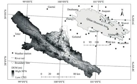
Figure 1 Location of study area
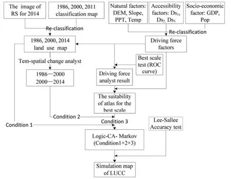
Figure 2 Research framework flowchart
3 Results
3.1 Land use change from 1986 to 2014
The land use and cover data sets for 1986, 2000 and 2014 were reclassified, with six new land use types,including farmland, woodland, grassland, settlement,water area, and bare land. These regions were calculated for land use and cover, with a total area of 10,001.91 km2(Table 1). By statistical analysis, the average area value for three phases of data, grassland area was the largest, followed by woodland, bare land, water area,farmland and settlement. Woodland decreased by 12.55%, while grassland, farmland, and settlement areas increased by 7.92%, 0.22%, and 0.03%, respectively,from 1986 to 2014. For the first phase (from 1986 to 2000, Table 2), woodlands had an obvious net reduction of 1,501.69 km2corresponding with environmental degradation, mainly distributed in the central mountains,near the Heihe River. In addition, bare lands were converted to grasslands, with net conversion of 232.62 km2,occurring in the central and southwestern section of the mountain. For the second phase (from 2000 to 2014,Table 3), total changing area was less than that in the first phase, farmlands and grasslands transferred to settlements by 0.3 and 1.1 km2, especially surrounding the Qilian and Sunan counties. The net change of bare land to grassland was 38.12 km2.
3.2 Driving force analysis
LUCC are influenced by natural and social factors,and their function is different. The change of natural factors is not apparent, but social factors may have a greater change in short term (Yang et al., 2016). The decision power and background factors include items such as climate, topography, and river network. The driving forces include items such as urban distribution,transportation facilities layout, and population density(Liu and Deng, 2009). The evolution process of LUCC is influenced by different spatial scale of research(Holling, 1992). Different spatial scales have different coupling results (Chen and Peter, 2000). Thus, it is very important to select the best spatial scale of studying(Cheng et al., 2004). In this paper, the training spatial scale, and the selection rule was based on initial remote sensing image, such as TM data with a resolution of 30 m (1 pixel × 1 pixel). Accordingly, the minimum training scale is 30 m (1 pixel × 1 pixel) and the maximum scale is the full scene image. The maximum scale was not selected, so we set the scale sample as 30 m (1 pixel × 1 pixel), 450 m (15 pixel × 15 pixel), 600 m (20 pixel × 20 pixel), 900 m (30 pixel × 30 pixel) and 1,200 m (40 pixel × 40 pixel). The process of training is to calculate the ROC value based on logistic regress analysis in SPASS20 software, referring to the standard of fitness (Li, 2011) to obtain the best spatial scale of 210m×210m. At the same time, the statistical parameter of logistic regress were tabulated under the best spatial scale (Table 4) and used to build the logistic regress equation between different land use and driving forces. Air temperature, precipitation, DEM, and slope have important influence on LUCC, especially, slope factor was obvious for woodland (β=0.05). The population factor played an important role (β=0.071) in settlement land change.

Table 1 The land use area and occupation in different periods (km2)

Table 2 Transfer matrix of land use and cover change from 1986 to 2000 (km2)

Table 3 Transfer matrix of land use and cover change from 2000 to 2014 (km2)
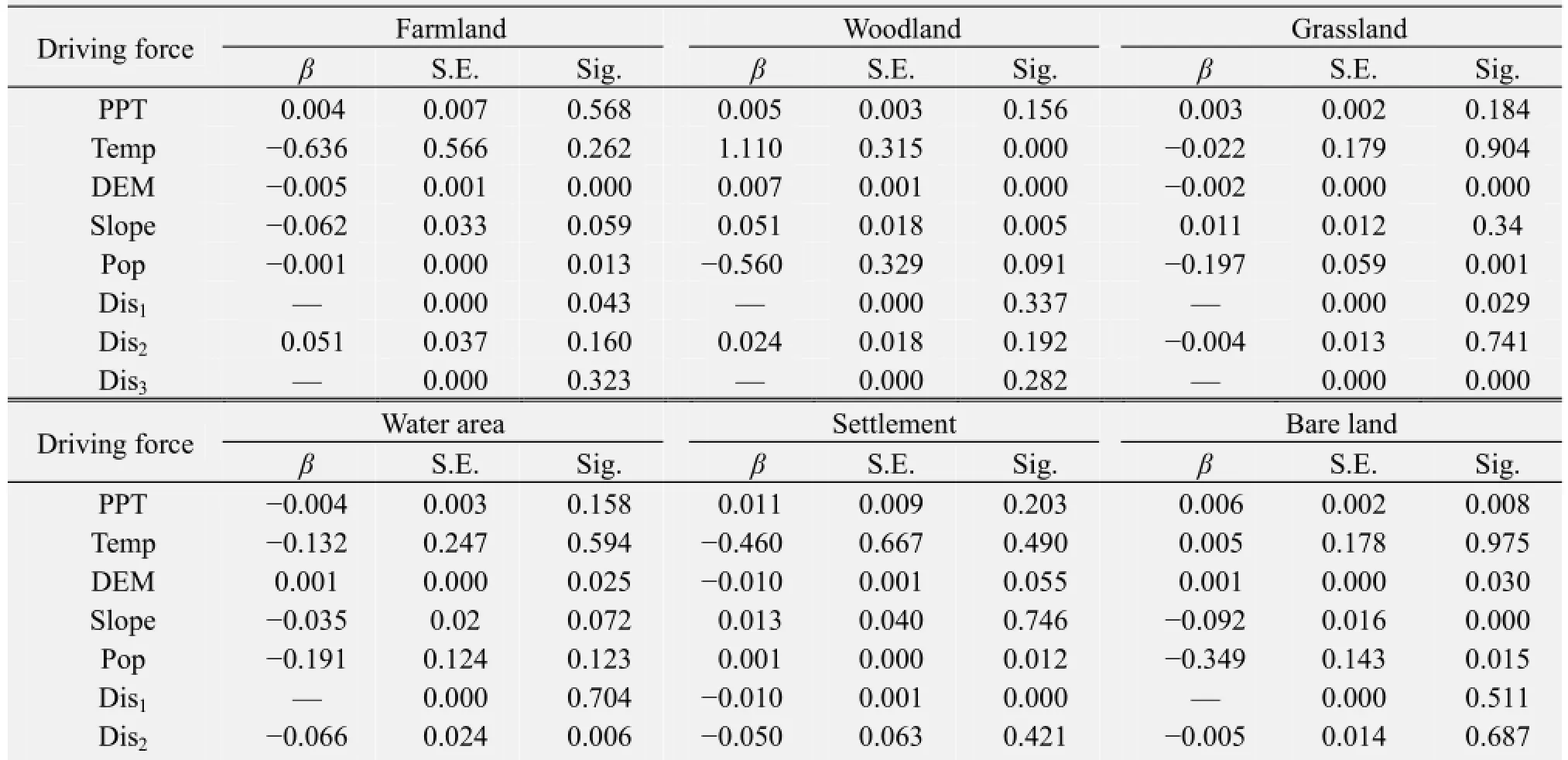
Table 4 The logistic regression result between LUCC and driving force factors

Dis2
3.3 Simulation and prediction of LUCC
3.3.1 Atlas suitability
Land use suitability mapping (Figure 3) was completed using the logistic regress equation and driving force raster data based on spatial analyst tool in Arcgis10.1 software. The span of suitability value is from 0 to 1, close to 1 indicates that it had a higher suitability for some land use and close to 0 indicates worse suitability in this area. The suitability value of land use for farmland is higher near Qilian Mountain and along both sides of Heihe River, with the highest value of 0.99. The woodlands are mainly distributed on the mountain at an elevation of 2,900-3,600 m, where the terrain played an important role in increasing woodland area. The high suitable value for water area was mainly concentrated in the Heihe river valley, and the suitability of the maximum value was 0.65.
3.3.2 Simulation and prediction map
The prediction process requires three kinds of data support: basis land cover image, transition area data set, and land suitability image atlas. The parameter settings include, (1) Number of Cellular Automata iterations: 14 years (2) Cellular Automata filter type: Standard 5×5 contiguity filter. We used land use and driving force factors data for 1986, 2000, and 2014 to simulate and predict the LUCC of Qilian Mountain for 2014 (The real land use data of 2014 to test the simulation result of 2014), 2028, and 2042. The simulation process requires three conditions for LUCC simulation for 2014 using the IDRISI Selva software (Eastman,2002): (1) land use data of 1986 and 2000, (2) the area transfer matrix from 1986 to 2000, (3) land use suitability atlas of 2000. The logistic regression analysis method was used to calculate the contribution (weight)of the composite driving force factors on land use andcover change, and the weight value was more objective and effective compared with MCE (Multi-Criteria Evaluation) and AHP (Analytic Hierarchy Process)methods. Logistic regression analysis could improve the precision of suitability atlas based on spatial analysis combined with weight value. The prediction map was generated using land use data, transfer matrix and suitability atlas based on Logistic-CA-Markov model in IDRISI Selva software, and the prediction result (2014)was tested by Lee-Sallee index which met the requirements. The indices increased from 0.43 to 0.89 for farmlands, from 0.55 to 0.82 for settlements, from 0.42 to 0.81 for woodlands, from 0.49 to 0.76 for water area, and from 0.29 to 0.66 for bare land (only part of the index was low). The nature driving force factors (such as DEM, slope) changed little over the short term. Thus, data set including temperature,precipitation, population and road network were updated to produce the suitability atlas of 2014. As a result, the simulation map of 2028 and 2042 for LUCC in Qilian mountain area was predicted (Figure 4). The simulation map shows that, in the natural environment, without environmental degradation,tremendous LUCC structural change will not occur,and typical characteristic of the vertical zonality of mountain will be remained. Farmland and settlement area will increase, but only in the vicinity of Qilian and Sunan counties.
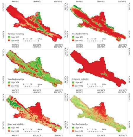
Figure 3 Distribution of land use suitability for 210 m (7 pixel × 7 pixel) scale in 2000 year (year 2014, omited)
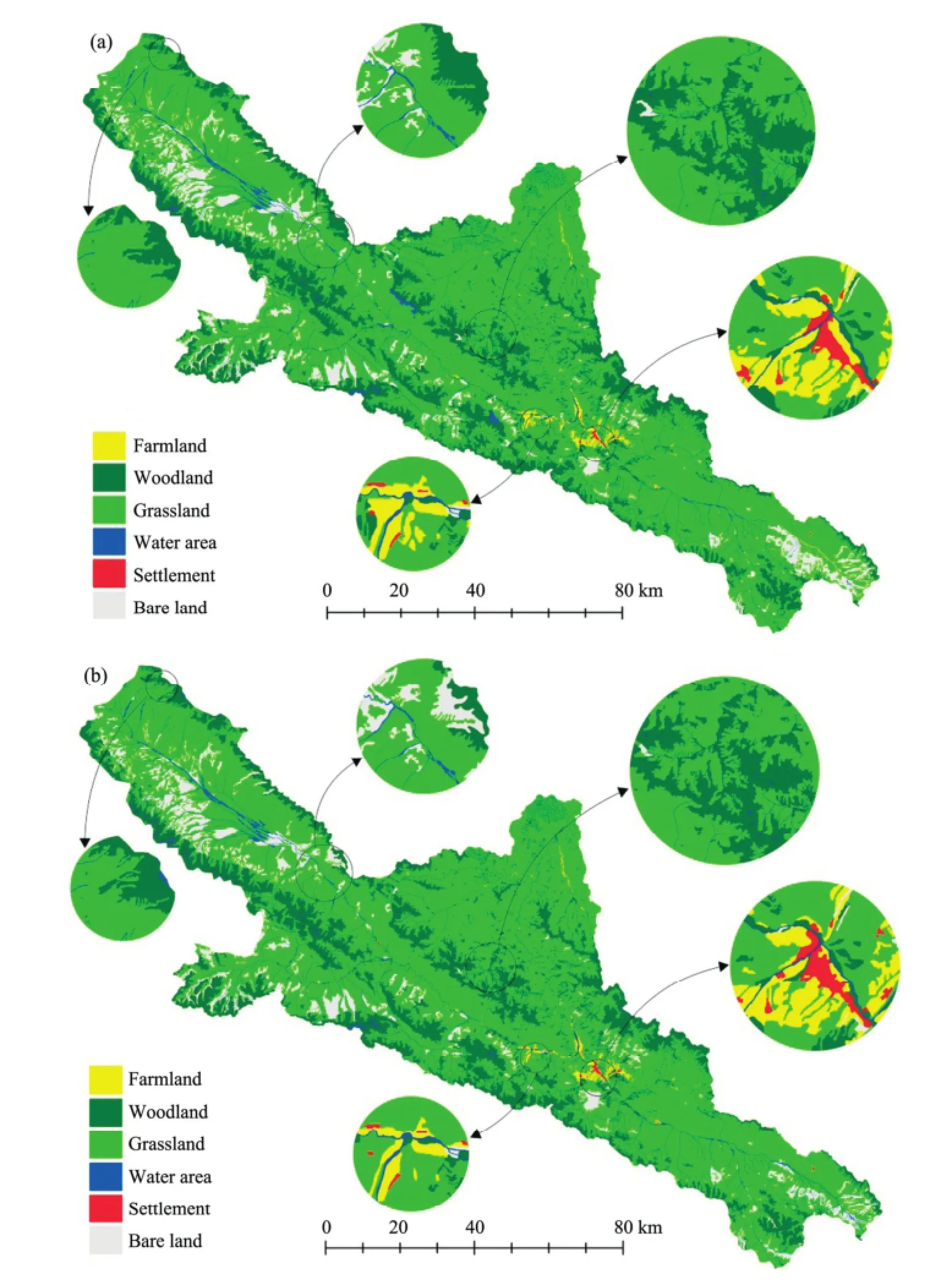
Figure 4 Simulation map of land use and cover change for (a) year 2028 and (b) year 2042
4 Discussion
We used land use and cover data sets of 1986, 2000 and 2014 for LUCC simulation (land use and cover change) along with analyzing the driving force mechanism. Predicted change over the next 27 years was based on the Logistic-CA-Markov coupling model.
During the period of 1986-2000, the grassland area obviously increased in the middle section of the mountain area. Land use and cover change between each other was less, but settlement area obviously increased, which is consistent with other studies (An et al., 2013; Liu et al., 2014). The spatial scale was very important for LUCC simulation and prediction. In the past,researchers had analyzed and compared different scales to select the best one (He et al., 2011; Huang et al., 2012;Qiao, 2012), based on Landsat TM data. In this paper,the best spatial scale was 210m×210m and it met the standard of ROC curve (Wang et al., 2015). Under the best scale, land use suitability distribution in 2000 and 2014 and the land use map reached good agreement. Over the next 27 years (2015-2042), farmland, woodland, grassland, settlement areas show an increasing trend, especially settlements with an obvious change of0.56%. The area of bare land will decrease by 0.89%. These results are basically consistent with the A1B scenario of IPCC in Zhang et al. (2013), such as unused land will decrease by 0.92%, construction area shows an increase trend and land use and cover do not change significantly. However, farmland area change was very different from Zhang et al. (2013). The causes are complex for LUCC. In this paper the eight kinds of driving factors are limited. Future studies should apply data such as livestock number and soil type, and mean air temperature should be converted to accumulated temperature. Improving comprehensiveness of the evaluation system can improve the prediction accuracy of LUCC.
5 Conclusions
According to statistical results, the area of land use has changed from 1986 to 2014, with woodland area decreased by 7.92%, while grassland, farmland, and settlement areas increased by 12.55%, 0.22%, and 0.03%, respectively. During 1986 to 2000, the forest area in the middle section of the mountain area decreased by 1,501.69 km2. Vegetation cover area has a net increase of 38.12 km2for grasslands from 2000 to 2014. The driving force system of land use and cover change includes eight evaluation indices, such as air temperature, precipitation, elevation, slope, river net,distance from the towns, distance from the road, and population density. The optimal simulation scale was 210m×210m, and the ROC test was passed using the multi-scale training method. Based on logistic regression analysis, the contribution (weight) of composite driving forces to the land use and cover change was obtained, and the weight value was more objective compared with AHP (Analytic Hierarchy Process) and MCE (Multi Criteria Evaluation). In the Qilian mountain area, the distribution of land use suitability was calculated through the spatial analyst module combined with the weight value. For the natural environment, we have conducted prediction of land use and cover distribution map in the mountainous area of Qilian Mountain in 2028 and 2042, and the Lee-Sallee index test was adopted. Over the next 27 years(2015-2042), farmland, woodland, grassland, settlement areas show an increasing trend, especially settlements with an obvious change of 0.56%. The area of bare land will be decreased by 0.89%. Without environmental degradation, tremendous structural change of LUCC would not occur, and the typical characteristics of the vertical zone of the mountain would remain stable. Farmland, settlement had increased, but only in the vicinity of Qilian and Sunan counties.
Acknowledgments:
This work is supported by National Natural Science Foundation of China (No. 4961038), Natural Science Foundation of Sichuan Province Education Department (No. 16ZB0402), Engineering and Technical College of Chengdu University of Technology Foundation (No. C122014014), the key research projects of Science and Technology Bureau of Leshan Town.
An ML, Zhang B, Sun LW, et al., 2013. Quantitative analysis of dynamic change of land use and its influencing factors in upper reaches of the Heihe River. Journal of Glaciology and Geocryology, 35(2): 255-263. DOI: 10.7522/j.issn.1000-0240. 2013.0042. (in Chinese)
Cai YL, 2002. Perspectives on innovation in physical geography. Acta Scientiarum Naturalium Universitatis Pekinensis, 36(4): 576-582. DOI: 10.13209/j.0479-8023.2000.082.
Chen DJ, Xu ZM, Ma AQ, 2002. The study of sustainable development of ecologically economic system in Qilian Mountain. Territory and Natural Resources Study, 3: 3-5. DOI: 10.16202/j.cnki.tnrs.2002.03.002. (in Chinese)
Chen YQ, Peter HV, 2000. Multi-scale spatial characterization of land use and cover in China. Scientia Geographica Sinica, 20(3): 197-202. DOI: 10.13249/j.cnki.sgs.2000.03.001. (in Chinese)
Cheng JC, Guo HD, Shi WZ, et al., 2004. Uncertainty of Remote Sensing Data. Beijing: Science Press. pp. 31-40. (in Chinese)Clarke KC, Hoppen S, Gaydos LJ, 1996. Methods and techniques for rigorous calibration of cellular automaton model of urban growth. In: Third International Conference/Workshop on Integrating GIS and Environmental Modeling. NCGIA National Center, pp. 11.
Dang SZ, Liu CM, Wang ZG, et al., 2012. Spatial-temporal distribution characteristics of snow cover in the upper reaches of Heihe River Basin over the past 10 years and the variation trend. Resource Science, 34(8): 1574-1581.
Dietzel CK, Clarke KC, 2007. Toward optimal calibration of the SLEUTH land use change model. Transactions in GIS, 11(1): 29-45. DOI: 10.1111/j.1467-9671.2007.01031.x
Eastman JR, 2002. IDRISI: Remote Sensing and Geography Information System. Beijing: Electronic Industry Press. pp. 110-122.
Fan SY, Zhao H, Zhao CZ, 2006. Analysis of the social and economic course of grassland overgrazing in Sunan Country Gansu Province. Arid Land Geography, 6(29): 921-928. DOI: 10.13826/j.cnki.cn65-1103/x.2006.06.025. (in Chinese)
Gai YY, Liu Y, Fan WJ, et al., 2014. Time series simulation, analysis and prediction of vegetation FAPAR in Heihe Basin. Acta Scientiarum Naturalium Universitatis Pekinensis, 50(3): 515-527. DOI: 10.13209/j.0479-8023.2014.081
Gong J, Xie YC, Jia ZZ, et al., 2014. Recent progress in land use and cover change in Heihe River Basin. Journal of Lanzhou University (Natural Sciences), 50(3): 391-395. DOI: 10.13885/j.issn.0455-2059.2014.03.015. (in Chinese)
Guan DJ, Li HF, Inohae T, et al., 2011. Modeling urban land use change by the integration of cellular automaton and Markov model. Ecological Modeling, 222(22): 3761-3772. DOI: 10.1016/j.ecolmodel.2011.09.009
He D, Jin FJ, Zhou J, 2011. The changes of land use and landscape pattern based on Logistic-CA-Markov Model. Geographical Sinica, 31(8): 903-910. DOI: 10.13249/j.cnki.sgs.2011.08.004.(in Chinese)
Holling CS, 1992. Cross-scale morphology, geometry, and dynamics of ecosystems. Ecological Monographs, 62(4): 447-502. DOI: 10.1007/978-1-4612-4018-1_30.
Huang XL, Liu DY, Feng ZK, et al., 2012. Prediction study on Tianjin land-use based on CA- Markov Model. Journal of Agricultural Science and Technology, 14(5): 84-89. DOI: 10.3969 /j. issn.1008-0864.2012. 05.13. (in Chinese)
Lan YC, Ding HW, Hu X, et al., 2015. The seasonal change characteristics of temperature, precipitation in the mountain areas of the Heihe River and their regional differences. Mountain Research,2(33): 294-302. DOI: 10.16089 /j.cnki.1008-2786.000037. (in Chinese)
Li W, 2011. Simulation of Land Use Based on CLUE-S Model. M.S. Thesis, Nanjing Normal University, pp. 33.
Li X, Ye JA, Liu XP, et al., 2007. Geographical Simulation System: Cellular Automaton and Multi Agent. Beijing: Science Press. pp. 40-49. (in Chinese)
Li ZL, Xu ZX, 2012. Characteristics of runoff time series for the upper reaches of Heihe River basin. Journal of Arid Land Resources and Environment, 26(9): 51-56. DOI: 10.13448/j.cnki.jalre.2012.09.035. (in Chinese)
Liu JW, Jin TT, Liu GH, et al., 2014. Changes in land use and soil and water conservation of the upper and middle reaches of Heihe river basin during 2000-2010. Acta Ecologica Sinica, 34(23): 7013-7025. DOI: 10.5846/stxb201303010328. (in Chinese)
Liu JY, Deng XZ, 2009. Progress of the research methodologies on the temporal and spatial process of LUCC. Chinese Science Bulletin, 54: 3251-3258. DOI: 10.1007/s11434-009-0733-y.
Meng JJ, Yan F, Zhao CH, 2010. Land use change simulation on the edge of metropolis-A case study of Chang-ping district in Beijing. Journal of Basic Science and Engineering, 18(2): 197-208. DOI: 10.3969/j.issn.1005-0930.2010.02.0002. (in Chinese)
Qiao ZH, 2012. The Landscape Pattern Change and Modeling of Changbai Mountain Reserve. M.S. Thesis, Northeast Normal University, pp. 18.
Tang GA, Yang X, 2013. Spatial Analysis of Geographic Information System. Beijing: Science Press. pp. 110-122. (in Chinese)
Turner II BL, Lambin EF, Reenberg A, 2007. The emergence of land change science for global environmental change and sustainability. PNAS, 104(52): 20666-20671. DOI: 10.1073/pnas. 0704119104
Verburg PH, 2010. The CLUE-S Modeling Framework. M.S. Thesis, Wageningen University, pp. 12.
Wang HJ, Jin XH, Zhang B, et al., 2010. NDVI variation and coupling analysis with climate change in northwest of China based on GIS and RS. Transactions of the CSAE, 26(11): 194-203. DOI: 10.3969/j.issn.1002-6819.2010.11.034. (in Chinese)
Wang JH, Gai CM, Zhao J, et al., 2014. Land-use Land-cover data of the Heihe River Basin. Cold and Arid Regions Sciences Data Center, Cold and Arid Regions Environmental and Engineering Research Institute, Chinese Academy of Sciences.
Wang YH, Yang DW, Lei HM, et al., 2015. Impact of cryosphere hydrological processes on the river runoff in the upper reaches of Heihe River. Journal of Hydraulic Engineering, 9(46): 1065-1069. DOI: 10.13243/j.cnki.slxb.20150001. (in Chinese)
Wu Li, Hou XY, Xu XL, et al., 2013. Land use and landscape pattern changes in coastal areas of Shandong Province. Transactions of the Chinese Society of Agricultural Engineering, 29(5): 207-216. DOI: 10.3969/j.issn.1002-6819.2013.05.028. (in Chinese)
Yang FH, Chen GD, Wang PP, 2016. Study on land use change and its driving forces in Ning'an city based on fractal theory. Research of Soil and Water Conservation, 2(23): 281-285. DOI: 10.13869/j.cnki.rswc.2016.02.051. (in Chinese)
Zhang CY, Zhao ZJ, 2015. Temporal and spatial change of land use/cover and quantitative analysis on the driving forces in the Yellow River Delta. Acta Scientiarum Naturalium Universitatis Pekinensis, 1(51): 151-157. DOI: 10.13209/j.0479-8023.2015.019.
Zhang L, Nan ZT, Yu WJ, 2013. Coupling LUCC and hydrological models to predict land use change and hydrological response under multiple scenarios. Journal of Geo-information Science,6(15): 836-838. DOI: 10.3724/SP.J.1047.2013.00829.
Zhu FG, Hu HW, Shen XH, 2011. SLEUTH model-based prediction of urban growth of Shanghai. Chinese Journal of Ecology, 30(9): 2107-2114. DOI: 10.13292/j.1000-4890.2011.0343. (in Chinese)
Wang HJ, Kong XD, Zhang B, 2016. The simulation of LUCC based on Logistic-CA-Markov model in Qilian Mountain area, China. Sciences in Cold and Arid Regions, 8(4): 0350-0358.
10.3724/SP.J.1226.2016.00350.
*Correspondence to: HaiJun Wang, Lecture of Engineering & Technical College of Chengdu University of Technology. No. 222, Xiaoba Road, Leshan, Sichuan 614000, China. E-mail: wanghaibo.2006@163.com
March 11, 2016 Accepted: June 13, 2016
杂志排行
Sciences in Cold and Arid Regions的其它文章
- Evolution of permafrost in Northeast China since the Late Pleistocene
- Uncertainty analysis of runoff and sedimentation in a forested watershed using sequential uncertainty fitting method
- Study of annual mass balance (2011-2013) of Rikha Samba Glacier, Hidden Valley, Mustang, Nepal
- An investigation of the effects of dust storms on rat lung using HRCT and blood gas analysis
- Remote-sensing data reveals the response of soil erosion intensity to land use change in Loess Plateau, China
- Impact of soil conditions on the physiological characteristics of maize plants in an arid region, Northwest China
