Study of annual mass balance (2011-2013) of Rikha Samba Glacier, Hidden Valley, Mustang, Nepal
2016-10-12SanjayaGurungBikasBhattaraiRijanKayasthaDorotheaStummSharadJoshiPradeepMool
Sanjaya Gurung, Bikas C. Bhattarai, Rijan B. Kayastha,Dorothea Stumm, Sharad P. Joshi, Pradeep K. Mool
1. Himalayan Cryosphere, Climate and Disaster Research Centre, Kathmandu University, Dhulikhel, 45200, Nepal
2. International Centre for Integrated Mountain Development, Lalitpur, 44700, Nepal
Study of annual mass balance (2011-2013) of Rikha Samba Glacier, Hidden Valley, Mustang, Nepal
Sanjaya Gurung1*, Bikas C. Bhattarai1, Rijan B. Kayastha1,Dorothea Stumm2, Sharad P. Joshi2, Pradeep K. Mool2
1. Himalayan Cryosphere, Climate and Disaster Research Centre, Kathmandu University, Dhulikhel, 45200, Nepal
2. International Centre for Integrated Mountain Development, Lalitpur, 44700, Nepal
ABSTRACT
Although Himalayan glaciers are of particular interest in terms of future water supplies, regional climate changes, and sea-level rises, little is known about them due to lack of reliable and consistent data. There is a need for monitoring these glaciers to bridge this knowledge gap and to provide field measurements necessary to calibrate and validate the results from different remote sensing operations. Therefore, glaciological observations have been carried out by the Cryosphere Monitoring Project (CMP) since September 2011 on Rikha Samba Glacier in Hidden valley, Mustang district in western Nepal in order to study its annual mass balance. This paper presents the first results of that study. There are 10 glaciers in Hidden Valley, named G1, G2, G3, up to G10. Of these, G5 is the Rikha Samba Glacier, which has the largest area (5.37 km2) in this valley and the highest and lowest altitudes (6,476 and 5,392 m a.s.l., respectively). The glacier mass balance discussed in this paper was calculated using the glaciological method and the equilibrium line altitude (ELA). The glacier showed a negative annual point mass balance along the longitudinal profile of its lower part from September 10, 2011 to October 3, 2012. Stake measurements from October 4, 2012 to September 30, 2013 indicated a negative areal average of annual mass balance -0.088±0.019 m w.e. for the whole glacier. Based on these observations, the ELA of the Rikha Samba Glacier is estimated at 5,800 m a.s.l. in 2013. This negative balance may be due to rising air temperatures in the region,which have been incrementally rising since 1980 accompanied by little or no significant increase in precipitation in that period. The negative mass balance confirms the general shrinking trend of the glacier.
ablation; accumulation; climate change; glacier mass balance; Himalayan glacier Citation: Gurung S, Bhattarai BC, Kayastha RB, et al., 2016. Study of annual mass balance (2011-2013) of Rikha Samba Glacier, Hidden Valley, Mustang, Nepal. Sciences in Cold and Arid Regions, 8(4): 0311-0318.
10.3724/SP.J.1226.2016.00311.
1 Introduction
Glaciers are highly sensitive to climate change, and their study is important for understanding environmental changes, especially in terms of changes in water resources (Immerzeel et al., 2010; Immerzeel et al., 2014). The response of glaciers to changes in climate is dependent on the glacier geometry and climatic setting(Oerlemans, 2001). To understand the climate-glacier relationship on a regional scale and to analyze the influences of both morphological (aspect, slope, elevation,latitude) and meteorological (temperature, precipitation)parameters on glacial changes, glaciological variables(mass balance, equilibrium line altitude (ELA)) at the scale of a mountain chain or a climatic region need to be measured (Rabatel et al., 2012).
The impact of climate change on Himalayan glaciers has increasingly become the subject of public and scientific debate (e.g., Bolch et al., 2012). Mass balance measurements are being carried out worldwide, but few ground-based measurements and modeling efforts have been carried out on Himalayan glaciers (Kayastha et al.,1999; Bolch et al., 2011; Fujita and Nuimura, 2011;Bolch et al., 2012; Nuimura et al., 2012; Wagnon et al.,2013). The evaluation of glacier mass balance is important to understand the implications for regional water resources and global sea-level changes (Fujita et al.,1998; Rignot et al., 2011; Jacob et al., 2012; Shepherd et al., 2012; Gardner et al., 2013). It is important to monitor the mass balance of Himalayan glaciers to better understand the impact of climate change on the volume of these glaciers.
Previous glacier mass balance studies in the Nepal Himalayas were limited to sporadic studies on Glacier AX010 and Rikha Samba Glacier since the 1970s and on Yala Glacier since the 1980s. A systematic study of glaciers in Nepal was first organized by Nagoya University and Kyoto University in Japan by the Glaciological Expedition to Nepal (GEN), led by Keiji Higuchi(Higuchi, 1976, 1977, 1978, 1980). They carried out a series of field studies in coordination with the Department of Hydrology and Meteorology (DHM), Government of Nepal (GoN). The first detailed study of Glacier AX010 was conducted in 1978-1979, followed by further investigations (Ageta et al., 1980; Ageta and Kadota, 1992; Kadota et al., 1997; Kayastha et al., 1999). Yala Glacier was studied intermittently since the 1980s,and Rikha Samba Glacier has been studied intermittently since 1974 (Fujii et al., 1976; Nakawo et al., 1976; Higuchi, 1977; Fujita et al., 1997, 2001; Fujita and Nuimura, 2011). However, these glaciers were not monitored continuously, mainly due to difficult access and financial constraints. In 2007 and 2009, long-term glacier monitoring programs were established on the Mera and Pokalde Glaciers by the Institute for Research and Development (IRD), France, and collaborators(Wagnon et al., 2013). Since 2011, glaciological observations have been carried out in the framework of the Cryosphere Monitoring Project (CMP) on Yala and Lirung glaciers in Langtang Valley, Rasuwa district, Nepal,and Rikha Samba Glacier in Hidden Valley, Mustang district, Nepal. Baral et al. (2014), Pradhananga et al.(2014), and Ragettli et al. (2015) have studied glaciological, glacio-hydrological, and meteorological aspects in the Langtang Valley through the CMP.
The main objectives of the research presented here were to analyze the mass balance of Rikha Samba Glacier based on observations from September 10, 2011 to September 30, 2013, to estimate the ELA, and to relate the mass balance to the climate in the same time period. Temperature and precipitation were analyzed to calculate the amount of total precipitation accumulation. Also, wind effects were observed to explain the more negative mass balance despite increases in the elevation.
2 Materials and methods
2.1 Study area
The study site for mass balance monitoring, Rikha Samba Glacier (28.83°N, 83.5°E), lies in the Sangda River watershed in the Mustang district in western Nepal within the Annapurna Conservation Area (Figure 1). The Hidden Valley, where there are 10 glaciers named as G1, G2, G3, and so on up to G10, lies inside this basin. G5, the largest debris-free glacier in this valley, is now known as the Rikha Samba Glacier(Nakawo et al., 1976). The highest and lowest altitudes of the glacier were determined from the Advanced Space borne Thermal Emission and Reflection Radiometer digital elevation model (ASTER DEM), with 30-m resolution. These data are distributed by the Land Processes Distributed Active Archive Center (LP DAAC), located at the U.S. Geological Survey(USGS) Center for Earth Resources Observation and Science (EROS). The values for the highest and lowest altitude of the glacier are 6,476 and 5,392 m a.s.l.,respectively. Its area is 5.37 km2with a length of 5.5 km. The altitude of the watershed ranges from 2,920 to 6,511 m a.s.l. and its area is 432.66 km2(Figure 2). The glacier outline has been delineated based on Landsat imagery from February 5, 2011.
2.2 Meteorological data
Data from three automated weather stations(AWSs) and a Nepal Department of Hydrology and Meteorology (DHM) base station at Jomsom (the latter is BS hereafter) have been used for analysis in this paper. One AWS was installed near the base camp on October 3, 2012 (5,287 m a.s.l.) by CMP (BS1hereafter), another was installed on October 1998 (5,267 m a.s.l.) by a Japanese team of scientists (BS2hereafter),and the third was installed by a team of Japanese scientists in September 2010 (BS3hereafter).
Temperature and wind data recorded at BS1and BS3were used for the analyses of the conditions on the glacier. From September 10, 2011 to July 16, 2012,data from BS3was used. Similarly, meteorological data for the period from October 1, 2012 to September 30, 2013 was obtained from BS3(Figure 2).
The annual air temperature and rainfall data from BS were used for climatic trend analysis. The trend analysis provides evidence of the annual changes in mass balance of the Rikha Samba Glacier. Air temperature data were missing in two periods (July 17 to September 30, 2012 and January 18 to May 31, 2013)due to technical problems with the sensors. Themissing data were filled with the help of air temperature data from BS. The lapse rate was calculated by using the data from BS1and BS for the period from June 6 to September 30, 2013; it was found to be 0.62 °C/(100m). This lapse rate value was used to fill in the missing temperature data of the BS1.
Data recorded at BS (2,744 m a.s.l.), located about 23 km east of Rikha Samba Glacier, were used to analyze the changes in mean air temperature (1957 to 2012) and precipitation (1980 to 2012). These data were provided by the DHM.
The precipitation gauge (pluviometer) installed at Rikha Samba Base Camp did not function well and,hence, rainfall data from a tipping bucket was extrapolated from the BS to estimate the amount of precipitation on Rikha Samba Glacier. The extrapolation of precipitation was done by using relation: where PJ is the precipitation recorded at BS and PRS is the precipitation estimated at the Rikha Samba Base Camp. This relationship was established by correlating the observed rainfall data collected at the BS and BS2from October 1998 to September 1999.

2.3 Mass balance
For mass balance measurements, five stakes were installed on the glacier at altitudes between 5,473 and 5,740 m a.s.l. in September 2011, and three more stakes at altitudes between 5,798 and 5,942 m a.s.l. were installed in 2012 (Figure 1). The stake lengths and snow depths were measured on October 3, 2012 and September 30, 2013.
The extrapolation of the mass balance data for the entire glacier from October 4, 2012 to September 30,2013 was done by considering 11 zones of 100-m height intervals (Figure 1). For each zone, the data from the stake inside the polygon was used to calculate the point mass balance. This mass balance value was multiplied by the area to get the extrapolated and calculated annual net mass balance for each zone. Above 5,900 m a.s.l. there was no observed point mass balance. The point mass balance observed at stakes at 5,740 and 5,896 m a.s.l., which have the same aspect and slope, were used to estimate the mass balance gradient for the period October 4, 2012 to September 30, 2013, and the same value of mass balance gradient was applied in the precipitation accumulation region of a representative area of the glacier. The areal average of the mass balance was then calculated.
In this study, the annual mass balance at the stakes was calculated using the change in snow depth and ice level obtained from the stake measurements, and snow density profiles obtained at each site by snow-pit analysis (270~457 kg/m3) during the field surveys. The density of the ice was assumed to be 870±40 kg/m3(Fujita et al., 2001).
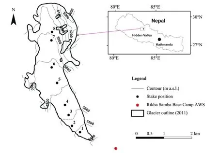
Figure 1 Location map of Rikha Samba Glacier in the Hidden Valley. Solid circles denote the stakes installed by the CMP for mass balance measurements
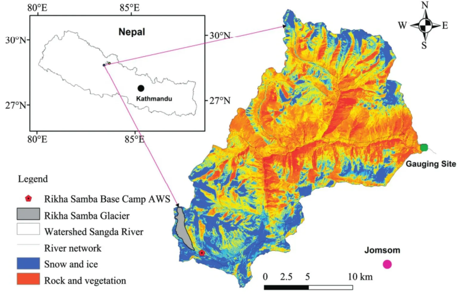
Figure 2 Location map of Sangda River Basin in Mustang district, Nepal (Landsat image February 2011)
The precipitation accumulation at each stake was calculated from the total solid precipitation, based on the rainfall data from the BS. To calculate the total solid precipitation at Rikha Samba Glacier Base Camp, the mean daily air temperature (Figure 3) from BS1and BS3, the temperature lapse rate of 0.62 °C/(100m), and the threshold temperature of 3.6 °C (Kayastha et al., 2005) were used to separate snow and rain during rainfall events. It was also assumed that the precipitation amount did not change with altitude on the glacier since the altitude range of the glacier is reasonably small. Due to unreliable precipitation data from BS1, the precipitation gradient with altitude was assumed to be constant. Ablation was calculated by subtracting the estimated precipitation accumulation from the observed mass balance.
The error in the mass balance calculations was estimated by using maximum density value (870+40 kg/m3), minimum density value (870-40 kg/m3) and actual density value (870 kg/m3) of ice. The absolute error value of areal average of the mass balance was ±0.019.

This absolute error of mass balance is calculated by following equations, where, Δx = absolute error in mass balance; xmax= maximum value of mass balance calculated using maximum ice density, minimum value of mass balance calculated using minimum ice density; xactual= actual value of mass balance calculated using mean ice density.
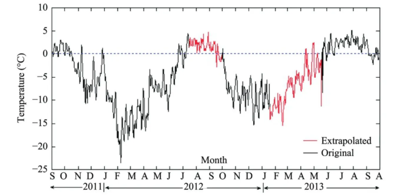
Figure 3 Variation of daily mean air temperature at the Rikha Samba Glacier Base Camp(BS3from September 10, 2011 to July 16, 2012 and BS1from October 1, 2012 to September 30, 2013)
3 Results
3.1 Meteorological observations
Temperature data recorded from September 10, 2011 to September 30, 2013, and wind speed and direction from October 1, 2012 to September 30, 2013, are shown in Figure 3. The total precipitation at Rikha Samba Base Camp obtained by extrapolation (Sec. 2.2) was 793 mm w.e. (October1, 2012 to September 30, 2013).
The mean daily temperature was below 0 °C in winter (October 17, 2011 to July 8, 2012 and September 23, 2012 to May 30, 2013). As the summer (July 9 to September 22, 2012 and May 24 to September 5, 2013)proceeded, the temperature remained above 0 °C. The lowest daily mean temperature was -23.56 °C, recorded on February 8, 2012, and the highest daily mean temperature was 5.19 °C recorded on July 29, 2013. The annual average temperature was -4.1 °C, which was slightly higher than the average value observed by Fujita et al. (2001), which was -4.6 °C.
The recorded wind speeds and directions at the Rikha Samba Glacier are shown in Figure 4. During the nighttime, northwesterly wind dominated, with some contribution from south to southeasterly flows. The dominant wind speed ranged from 2.1 to 3.6 m/s,with a maximum wind speed of up to 5.7 m/s. However, during the daytime, the prevailing wind direction was south to southeasterly, followed by northwesterly. The wind speed was weaker during the day than at night. Therefore, katabatic wind blows down the valley during the night, while valley winds dominate on the glacier during the day.
3.2 Climatic trend analysis
The distribution of air temperatures from 1980 to 2012 showed a clear warming trend of 0.023 °C per year, which was statistically significant at the 95% confidence level based on a Mann-Kendall test (Figure 5). The precipitation trend analysis from 1957 to 2012 showed a slightly increasing trend of 0.57 mm per year, but this was not statistically significant at the 95% confidence level.
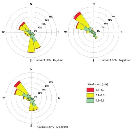
Figure 4 Distribution of hourly wind speeds and directions in daytime, nighttime, and 24-hour mean recorded at Rikha Samba Base Camp (BS1from October 1, 2012 to September30, 2013); daytime was 6:00 a.m. to 6:00 p.m., and nighttime was 6:00 p.m. to 6:00 a.m

Figure 5 Distribution of annual mean air temperatures (1980 to 2012) and rainfall (1957 to 2012) recorded at Jomsom BS
3.3 Mass balance and hypsography
The annual mass balance at stake sites 1, 2, 3, 4, and 5 installed along the longitudinal profile of the lower part of the glacier were -3.98±0.22 m w.e, -2.92±0.16 m w.e., -1.87±0.10 m w.e., -1.24±0.06 m w.e., and -1.36±0.07 m w.e. from September 10, 2011 to October 3, 2012, respectively. From October 4, 2012 to September 30, 2013 the areal average annual mass balance for the whole glacier was -0.088±0.019 m w.e.
Three stakes (4, 6, and 8) were lost and the measurements at the remaining five stakes (1, 2, 3, 5, and 7)for the period from October 4, 2012 to September 30,2013 showed a maximum negative mass balance of -2.55±0.14 m w.e. at stake 1 on the lower part of glacier, and a maximum positive annual mass balance of 0.19±0.00 m w.e. at stake 7 on the upper part of glacier. The estimated mass balance gradient for the period October 4, 2012 to September 30, 2013 was 0.198 m w.e./(100m), and the same value of mass balance gradient was applied in the precipitation accumulation region of a representative area of the glacier. The areal average of the mass balance was then calculated to be -0.088±0.019 m w.e. The estimated ELA of the glacier was at 5,800 m a.s.l. in 2013. The calculated net balance, precipitation accumulation, and ablation at each stake site of Rikha Samba Glacier during that period are shown in Figure 6 and Table 1.
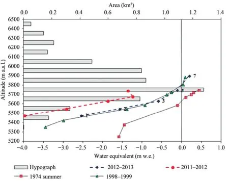
Figure 6 Hypsography of Rikha Samba Glacier (100-m intervals) based on ASTER DEM of 30-m resolution.Dotted-line circles and diamonds denote the mass balances observed in the periods from September 10, 2011 to October 3, 2012 and October 4, 2012 to September 30, 2013, respectively. The mass balance profile during the summer of 1974 is shown by the red square with the solid line (after Fujii et al., 1976),and in October 1998 to October 1999 is shown by the green triangle with the solid line (after Fujita et al., 2001)

Table 1 Stake number, altitude, mass balance, precipitation accumulation, and ablation at each stake site on Rikha Samba Glacier (2011-2013)
4 Discussion and conclusion
Our mass balance results showed more error in the lower part of the glacier and less towards the upper part (toward the ELA) of the glacier; a similar result was shown by Fujita et al. (2001). However, large errors may also have arisen from the high spatial variability of the point balance in the precipitation accumulation area, as suggested by Beedle et al.(2014). In addition, the ELA of Rikha Samba Glacier was 5,800 m a.s.l. in 2013. Fujita and Nuimura (2011)used an energy-mass balance model to show the heterogeneous distribution of the ELA trend for the Rikha Samba Glacier from 1974 to 2010.
The area-altitude distribution of Rikha Samba Glacier has a broad maximum between 5,600 and 6,000 m a.s.l., which accounts for about two-thirds of its total area (Figure 6). Lower and higher parts of the glacier are very steep and narrow, while the middle parts are relatively flat and wide (Figure1).
The altitudinal distribution of mass balance (Figure 6) shows that the annual mass balance at stake 4 was less than that at stake 5 for the period September 10,2011 to October 3, 2012. This might have been due to the position of stake 5 on the eastern margin of the glacier, facing the windward side and thus subject to more removal of snow by wind and hence resulting in more ablation. A similar result was reported by Fujii et al. (1976). Higher precipitation during 2012 compared to 2011 led to less negative mass balances for the year 2012-2013 than for 2011-2012 at each of the stake sites. Fujita and Nuimura (2011) used an energy-mass balance model to calculate the annual net balances for Rikha Samba Glacier from 1974-1994 and 1998-2010,which were found to be -0.566 m w.e. and -0.479 m w.e., respectively. Compared to the annual areal net balance of Rikha Samba Glacier during 2012-2013(-0.088±0.019 m w.e.), there were more negative glacier mass balances in those two earlier study periods.
The negative glacier mass balance at Rikha Samba Glacier is due to the statistically significant rise in temperature since 1980 (Figure 5). The impact of precipitation change on the glacier is not so pronounced because the long-term trend (1959-2012) for precipitation is not statistically significant (Figure 5). Because of a significant rise in temperature, accelerated melting of snow and ice is more likely. On the other hand, the insignificant change in the rainfall amount further contributed to less ice accumulation over the study period. The negative glacier mass balance during 2012-2013 was primarily controlled by the increase in temperature, even though precipitation increased slightly; the slightly increased precipitation accumulation could not offset ice losses due to surface melting driven by higher temperature. Negative mass balance has also been observed in earlier studies (e.g., Fujita et al., 2001; Fujita and Nuimura, 2011). The results presented in this paper indicate a continuation of a secular trend toward more negative mass balances in the Rikha Samba Glacier.
These conclusions are the preliminary results of a scientific study initiated by the CMP which aims to give an account of meteorological and glacio-hydrological observations in the glacierized Sangda River Basin. This information can also be of great use in determining the ultimate state of the cryosphere of the Himalayan region.
Acknowledgments:
We are very grateful to the HKH Cryosphere Monitoring Project implemented by the International Centre for Integrated Mountain Development (ICIMOD) and supported by the Norwegian Ministry of Foreign Affairs. This study was partially supported by core funds of ICIMOD contributed by the governments of Afghanistan, Australia, Austria, Bangladesh, Bhutan,China, India, Myanmar, Nepal, Norway, Pakistan,Switzerland, and the United Kingdom. We would also like to thank the CMP project partners for their help in carrying out this study, including the Himalayan Cryosphere, Climate and Disaster Research Center,Kathmandu University; the Central Department of Hydrology and Meteorology, Tribhuvan University;the Department of Hydrology and Meteorology, Gov-ernment of Nepal; and the Water and Energy Commission Secretariat, Government of Nepal. We would like to express our gratitude to Associate Professor Dr. Koji Fujita, Nagoya University of Japan, for providing the meteorological data of the study area. We are very grateful to Dr. Joseph Shea of ICIMOD for processing the meteorological raw data. We also thank Niraj S. Pradhananga, Abhishek Manandhar, Lea Hartl,Maxime Harter and Prashant Baral for providing valuable input during this study.
Ageta Y, Kadota T, 1992. Predictions of changes of glacier mass balance in the Nepal Himalaya and Tibetan Plateau: a case study of air temperature increase for three glaciers. Annals of Glaciology, 16: 89-94.
Ageta Y, Ohata T, Tanaka Y, et al., 1980. Mass balance of glacier AX010 in ShorongHimal, east Nepal during the summer monsoon season. Journal of Japanese Society of Snow and Ice(Seppyo), 41: 34-41.
Baral P, Kayastha RB, Immerzeel WW, et al., 2014. Preliminary results of mass-balance observations of Yala Glacier and analysis of temperature and precipitation gradients in Langtang Valley, Nepal. Annals of Glaciology, 55(66): 9-14. DOI: 10.3189/2014AoG66A106.
Beedle MJ, Brian-Menounos B, Wheate R, 2014. An evaluation of mass-balance methods applied to Castle Creek Glacier, British Columbia, Canada. Journal of Glaciology, 60(220): 262-276.
Bolch T, Kulkarni A, Kääb A, et al., 2012. The state and fate of Himalayan glaciers. Science, 336(6079): 310-314.
Bolch T, Pieczonka T, Benn DI, 2011. Multi-decadal mass loss of glaciers in the Everest area (Nepal Himalaya) derived from stereo imagery. The Cryosphere, 5(2): 349-358.
Fujii Y, Nakawo M, Shrestha ML, 1976. Mass balance studies of the glaciers in Hidden Valley, Mukut Himal. Seppyo. Journal of Japanese Society of Snow and Ice, 38: 17-21.
Fujita K, Nakawo M, Fujii Y, et al., 1997. Changes in glaciers in Hidden Valley, MukutHimal, Nepal Himalayas, from 1974 to 1994. Journal of Glaciology, 43(145): 583-588.
Fujita K, Nakazawa F, Rana B, 2001. Glaciological observations on Rikha Samba Glacier in Hidden Valley, Nepal Himalayas, 1998 and 1999. Bulletin of Glacier Research, 18: 31-35.
Fujita K, Takeuchi N, Seko K, 1998. Glaciological observations of Yala Glacier in Langtang Valley, Nepal Himalayas, 1994 and 1996. Bulletin of Glacier Research, 16: 31-35 .
Fujita K, Nuimura T, 2011. Spatially heterogeneous wastage of Himalayan glaciers. Proceedings of the National Academy of Sciences, 108(34): 14011-14014.
Gardner AS, Moholdt G, Cogley JG, et al., 2013. A reconciled estimate of glacier contributions to sea level rise: 2003 to 2009. Science, 340(6134): 852-857. DOI: 10.1126/science.1234532. Higuchi K, 1976. Glaciers and climates of Nepal Himalayas-Report of the Glaciological Expedition to Nepal. Journal of Japanese Society of Snow and Ice (Seppyo), 38: 130
Higuchi K, 1977. Effect of nocturnal precipitation on the mass balance of the Rikha Samba Glacier, Hidden Valley, Nepal. In: Higuchi K, Hakajima C, Kusunoki K (eds.). Glaciers and Climates of Nepal Himalayas. Report of the Glaciological Expedition to Nepal- Part 2. Journal of Japanese Society of Snow and Ice (Seppyo), 39: 43-49.
Higuchi K, 1978. Outline of the glaciological expedition to Nepal(3). In: Higuchi K, Hakajima C, Kusunoki K (eds.). Glaciers and Climates of Nepal Himalayas. Report of the Glaciological Expedition to Nepal- Part 3. Journal of Japanese Society of Snow and Ice (Seppyo), 40: 1-3.
Higuchi K, 1980. Outline of the glaciological expedition to Nepal(4). In: Higuchi K, Hakajima C, Kusunoki K (eds.). Glaciers and Climates of Nepal Himalayas. Report of the Glaciological Expedition to Nepal- Part 4. Journal of Japanese Society of Snow and Ice (Seppyo), 41: 1-4.
Immerzeel WW, Petersen L, Ragettli S, et al., 2014. The importance of observed gradients of air temperature and precipitation for modeling runoff from a glacierized watershed in the Nepalese Himalayas. Water Resources Research, 50(3): 2212-2226.
Immerzeel WW, Van Beek LPH, Bierkens MFP, 2010. Climate change will affect the Asian water towers. Science, 328(5984): 1382-1385.
Jacob T, Wahr J, Pfeffer WT, et al., 2012. Recent contributions of glaciers and ice caps to sea level rise. Nature, 482(7386): 514-518. DOI: 10.1038/nature10847.
Kadota T, Fujita K, Seko K, et al., 1997. Monitoring and prediction of shrinkage of a small glacier in the Nepal Himalayas. Annals of Glaciology, 24: 90-94.
Kayastha RB, Ageta Y, Fujita K, 2005. Climate and Hydrology Mountain Areas. Wiley: West Sussex, England, pp. 7-14.
Kayastha RB, Ohata T, Ageta Y, 1999. Application of a mass balance model to a Himalayan Glacier. Journal of Glaciology,45(151): 559-567
Nakawo M, Fujii Y, Shrestha ML, 1976. Flow of glaciers in Hidden Valley, Mukut Himal. Journal of Japanese Society of Snow and Ice (Seppyo), 38: 39-43.
Nuimura T, Fujita K, Yamaguchi S, et al., 2012. Elevation changes of glaciers revealed by multitemporal digital elevation models calibrated by GPS survey in the Khumbu region, Nepal Himalaya, 1992-2008. Journal of Glaciology, 58(210): 648-656.
Oerlemans J, 2001. Glaciers and Climate Change. CRC Press.
Pradhananga NS, Kayastha RB, Bhattarai BC, et al., 2014. Estimation of discharge from Langtang River basin, Rasuwa, Nepal, using a glacio-hydrological model. Annals of Glaciology,55(66): 223-230. DOI: 10.3189/2014AoG66A123.
Rabatel A, Bermejo A, Loarte E, et al., 2012. Can the snowline be used as an indicator of the equilibrium line and mass balance for glaciers in the outer tropics? Journal of Glaciology, 58(212): 1327-1336.
Ragettli S, Pellicciotti F, Immerzeel W, et al., 2015. Unraveling the hydrology of a Himalayan watershed through integration of high resolution in-situ data and remote sensing with an advanced simulation model. Advances in Water Resources, 78: 94-111. DOI: 10.1016/j.advwatres. 2015.01.013.
Rignot E, Velicogna I, Van den Broeke MR, et al., 2011. Acceleration of the contribution of the Greenland and Antarctic ice sheets to sea level rise. Geophysical Research Letters, 38(5): L05503. DOI: 10.1029/2011GL046583.
Shepherd A, Ivins ER, Geruo A, et al., 2012. A reconciled estimate of ice-sheet mass balance. Science, 338(6111): 1183-1189. DOI: 10.1126/ science.1228102.
Wagnon P, Vincent C, Arnaud Y, et al., 2013. Seasonal and annual mass balances of Mera and Pokalde glaciers (Nepal Himalaya)since 2007. The Cryosphere, 7: 1769-1786.
*Correspondence to: Sanjaya Gurung, Himalayan Cryosphere, Climate and Disaster Research Centre, Kathmandu University, Dhulikhel, Nepal. E-mail: grg.sanjaya@gmail.com
March 11, 2016 Accepted: June 24, 2016
杂志排行
Sciences in Cold and Arid Regions的其它文章
- Evolution of permafrost in Northeast China since the Late Pleistocene
- Uncertainty analysis of runoff and sedimentation in a forested watershed using sequential uncertainty fitting method
- An investigation of the effects of dust storms on rat lung using HRCT and blood gas analysis
- Remote-sensing data reveals the response of soil erosion intensity to land use change in Loess Plateau, China
- Impact of soil conditions on the physiological characteristics of maize plants in an arid region, Northwest China
- Effects of artificial vegetation arrangement and structure on the colonization and development of biological soil crusts
