Study of an Early Silurian-Early Permian paleo-weathering profile in Zunyi,north Guizhou Province,China
2015-10-25XiaohuiXiongJiafeiXiaoRuizhongHuYiWangJianWangXiugenFu
Xiao-hui Xiong·Jia-fei Xiao·Rui-zhong Hu· Yi Wang·Jian Wang·Xiu-gen Fu
Study of an Early Silurian-Early Permian paleo-weathering profile in Zunyi,north Guizhou Province,China
Xiao-hui Xiong1,2,3·Jia-fei Xiao1·Rui-zhong Hu1· Yi Wang4·Jian Wang3·Xiu-gen Fu3
To understand and help settle the controversy around the living time of Pinnatiramosus qianensis Geng,a paleo-weathering profile situated in the town of Yongle near the city of Zunyi,north Guizhou Province,China,was analyzed.The profile formed during a break in sedimentation between the Early Silurian and the Early Permian. Paleosol developed with a depth of several meters.The fossil plant P.qianensis Geng is present,but only in the lower portions(Layer 2)of the paleosol.Another plant with an irregularly branching system is found in Layers 2 and 3.The distinct geochemical characteristics of the lower and upper portions of the Gaojiayan paleosol indicate a compound genesis.Its lower portions(Layers 1 and 2)resulted from in situ weathering of silty mudstone of the lower Silurian Hanjiadian Formation.The upper portions(Layer 3)are allochthonous.Transgression brought substantial concentrations K and Na,and led to K-and Naenrichment in the profile.Pumping of vascular plants and downward leaching enhanced the K enrichment in the middle portions.A superior preservation of P.qianensis Geng was observed in an exposure of Layer 2.Mass balance calculation indicates a great K enrichment related to bioaccumulation in the top of Layer 2 and a K loss in Layer 3.Fossil plants(e.g.,P.qianensis Geng)preserved in the paleosol are Permian rooting systems growing down into the lower Silurian rocks.
Paleosol·Transgression·Biological process· Early Silurian—Early Permian·Pinnatiramosus qianensis Geng
1 Introduction
Paleosols,the weathering products of the geological past,have attracted increasing attention since they were recognized by James Hutton in 1795(Retallack and Mcdowell 1988).A paleosol is reflective of the paleo-environment in which it formed and of the material present during the paleo-weathering processes.The geochemical composition,thickness,maturity,and preservation of paleosol can be used to interpret regional tectonic activity and landscape evolution(Cerling 1992;Driese and Foreman 1992;Holland and Rye 1997;Kraus 1999;Riebe et al.2004).Element distribution in a paleosol profile can be influenced by intense weathering.Elemental analysis can reveal loss and enrichment in different sections relative to that of the bedrock.
Paleosols do not only exist in a variety of continental depositional settings,including eolian(Brimhall et al. 1988;Soreghan et al.1997),palustrine(Tandon et al. 1995),and deltaic(Arndorff 1993),but are also found in marginal marine strata(Lander et al.1991)and in marine strata in cases that sea-level fell and exposed marine sediment(Webb 1994).Paleosols evolved during long breaks in sedimentation,and often show compound,composite,or cumulative characteristics.Insignificant erosion combinedwith rapid,unsteady sedimentation is generally related to compound paleosols.A rate of pedogenesis in excess of the rate of deposition is associated with composite paleosols. Thick,cumulative paleosols indicate that erosion was insignificant and that sedimentation was relatively steady(Kraus 1999).
We studied the Gaojiayan paleo-weathering profile.It formed during a break in sedimentation between the Early Silurian and the Early Permian.The time break was also an important period for bauxite deposit formation in this area,especially during the Carboniferous(Liu 1993,2001;Shengand Liao2010).This paleosol has attracted increasing attention in recent years due to the presence of an ancient vascular plant(Pinnatiramosus qianensis Geng),which has been considered to be the earliest vascular plant—a claim recently called into question(Cai et al. 1996;Edwards et al.2007;Wang et al.2013).We hope to contribute evidence to the debate with this paper.Major and trace elements were measured to illustrate the compound genesis of the Gaojiayan profile,which is composed of the lower in situ weathering portions and the upper allochthonous portions.Fossil plants preserved in the paleosol are proposed to be a Permian rooting system that extended into Lower Silurian rocks.
2 Geological background and features of studied profile
During the Early Silurian,as part of the Kwangsian Movement,the entire Yangtze Platform was uplifted by the end of the Telychian or possibly in the earliest Wenlock.It was then subjected to prolonged erosion and weathering(Edwards et al.2007).The overlying marine transgressive sequences are variably of the Upper Devonian through the Carboniferous or Permian ages,suggesting time breaks of about50—130 Ma(BureauofGeologyandMineral Resources of Guizhou Province 1987;Chen et al.2002;Edwards et al.2007).During these breaks,the Gaojiayan paleosol developed,and terrestrial vegetation would have evolved.
The Gaojiayan profile is located in the town of Yongle near Zunyi,north Guizhou Province(Fig.1).It is exposed onaroadcutneartheGaojiayanVillage(Fig.2;27°53′5.5′′N,107°22′18.5′′E).At the top of the profile,the Liangshan Formation(Fm)is comprised of black mediumto thin-bedded siliceous rocks.It has a thickness of about 2 m.
Light-purplish to rosy mudstone and conglomerate,with a thickness of about 0.33 m,are below the Liangshan Fm,which marks a sedimentary discontinuity.Gravels are wellrounded and composed largely of gray mudstone.Below the discontinuity,the paleosol,with a total thickness of about 2.66 m,is comprised of mottled clayey mudstone in the upper portions and gray mudstone in the lower portions. At the bottom,it gradually changes to gray-black silty mudstone and gray-green silty mudstone and shales of the Hanjiadian Fm of the Early Silurian(Fig.2).
Hanjiadian Fm consists of dominantly gray-green and yellow-green mudstone,silty mudstone,and shale,indicating low-energy,tidal-flat or shallow-shelf environments(Guo et al.2004;Zhang and Nie 2006;Zhu et al.2010). Paleogeographically,the sequences described here were depositedwithinabroad,shallowembaymentoftheYangtze Sea on the northern margin of the Cathaysian landmass(Fig.1a).The absence of any coarse clastic input into the Hanjiadian sequences both at Yongle and more widely across the Yangtze Platform indicates that the Cathaysian LandwasoflowreliefthroughouttheLateLlandovery,with negligiblesurfacerunoff(Edwardsetal.2007).TheYangtze Platform experienced a rapid regression to non-marine environments above this level according to sea-level curves(Rong et al.1984;Johnson et al.1985).
Fossil plants(root traces)are distributed in the studied paleosol.The famous P.qianensis Geng(Geng 1986)was identified in the Gaojiayan profile,but only in Layer 2(Fig.3).Another plant with an irregularly branching system(see Fig.15 in appendix)was identified not only in Layer 2 but also in the lower portion of Layer 3(Fig.3).
3 Sampling and analytical method
To collect samples,a fresh section was excavated manually on the roadcut.Based on different colors,lithologies,and weathering degrees at various positions,we divided the profile into five layers.Forty-one samples were collected from the top to the bottom at various intervals:
Layer 5(>2 m)black siliceous rocks of the Liangshan Fm.One sample(GJYII-22H)was collected;
Layer 4(0.33 m)light-purplish to rosy shale,and muddy basal conglomerate.Six samples(GJYII-B2H—GJYIIB7H)were collected at intervals of 4 to 10 cm;
Layer 3(1.38 m)mottled mudstone and clayey mudstone.Sixteen samples(GJYII-B8H—GJYII-B23H)were collected.Most of them were semi-consolidated;six samples(GJYII-B13H—GJYII-B18H)were dense and hard. The sampling interval was 5—10 cm.The plant with an irregularly branching system was found in the lower portions of this layer.
Layer 2(0.98 m)gray mudstone.All 12 samples(GJYII-12H—GJYII-2H)collected in this layer were semiconsolidated and rich in fossil plants(e.g.,P.qianensis Geng)with a sampling interval of 5—15 cm;

Fig.1 a Location of studied profile,paleo-geographical reconstruction of the late Aeronian(late Middle Llandovery)time in early Silurian for Guizhou Province(modified after Edwards et al.2007,Figure 2 and Rong et al.1996,Figure 5)and regional stratigraphy(bottom left inset);b Regional traffic of Northern Guizhou(modified after Li and Rong 2007,Figure 1a)
Layer 1(0.3 m)gray-black silty mudstone.One sample(GJYII-1H)was collected.
Due to difficult sampling at the paleosol collection site,we collected five bedrock samples(GJYI-5H—GJYI-1H)from a paleo-weathering profile of the same horizon 35 m away.The distribution of samples from the Gaojiayan profile is shown in Fig.3.
Before analyses of major and trace elements(including rare earth elements—REEs),all bulk samples were ground into powder(200 mesh).The major elements were determined using X-ray fluorescence spectroscopy.The instrument used was an Axios(PW4400)with analytical uncertainty<10%.Trace elements were analyzed using inductive-coupled plasma-mass spectroscopy(ICP-MS)techniques(PerkinElmer ELAN DRC-e)with analytical uncertainty<10%.In addition,some samples were selected for mineral analysis using X-ray diffraction(XRD)and determination of Boron concentration with the help ofOptima 5300V.The above analyses and measurements were all performed at the Institute of Geochemistry,Chinese Academy of Sciences,with the exception of determination of Boron which was completed at the Testing and Analysis Center of Guizhou Normal University.
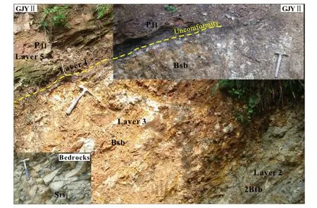
Fig.2 The outcrop of studied profile(GJYII),Bedrock is gray-green silty mudstone of Hanjiadian Formation of Early Silurian.Subordinate descriptors(s,t)and master horizons(B,BC,C,R)follow the definitions in Retallack(1988)in this and subsequent figures
4 Results
The contents of major,trace,and rare earth elements for samples collected from the Gaojiayan profile are listed in Tables 1,2,and 3,respectively.Elemental contents of paleosol samples are notably different from corresponding values in the bedrock(Fig.4).The main component of the Liangshan Fm siliceous rocks is SiO2,accounting for 84.13%.Samples with SiO2content between 40 and 50 wt%dominated the studied paleosol,and an increase in SiO2content downwards was observed.However,contents of Al2O3and K2O varied with depth.A good correlation exists between Al2O3and K2O,likely because they are the main components of illite,the dominant mineral according to XRD data.Mobile components like CaO,MgO,and MnO leach strongly,and were depleted relative to bedrock. Contents of Fe2O3and P2O5showed great losses relative to bedrock in most portions,but were enriched in partial horizons owing to leaching from the upper portions.These data suggest that the study profile experienced extensive chemical weathering.However,less mobile components like TiO2,Nb,Zr,Th,Cr,and V showed enrichment relative to bedrock throughout the paleosol,with the degree of enrichment displaying a sharp increase upwards at the contact of Layers 2 and 3.
Alkali metals(Na and K)showed enrichment in most horizons of the paleo-weathering profile(Fig.4).K-and Na-enrichment in a paleosol is nearly impossible after long-term weathering in a warm and rainy environment between 20°S and 10°N(Liao 1999;Li and Rong 2007)if no other geological processes are involved.With the help of an A—CN—K(Al2O—CaO*+NaO—K2O)triangular diagram(Fig.5)(Fedo et al.1995),the weathering conditions of the studied profile can be well-illustrated.The diagram shows the weathering trend paralleling the A—CN line at the early stage,then following a path toward the K2O apex.Most samples plot close to the area where illite or muscovite lies,implying the addition of K to the weathering profile.Weathering indices CIA—K and PIA can be used to estimate weathering intensity,but should be appliedwithcautionforKmetasomatismandNa metasomatism.
The REE distribution patterns normalized by the North American shale composite(NASC)show distinct differences between Layers 1 and 2 and Layer 3(Fig.6).Layers 1 and 2 tested rich in LREEs,and Layer 3 returned low LREE/HREE ratios.HREEs were less mobile relative to LREEs throughout the profile.The distribution patterns of LREEs in Layer 3 were very regular.The concentration ofLREEs increased with depth in Layer 3,implying that LREEs leached from the upper parts,and concentrated in the lower parts.

Fig.3 Distribution of samples in study profile and lithology descriptions
5 Discussion
5.1 In-situ weathering or allochthonous product?
5.1.1 Characteristics of less mobile elements
There are variations in mobility among different elements during chemical weathering.Previous studies indicate that low-valent elements such as alkali metal and alkaline earth metal leach easily and are depleted in acid soil.In contrast,other high-valent elements(e.g.,high field strength elements Nb,Ta,Zr,Hf,Ti,and Th)are more resistant and accumulate readily(Nesbitt et al.1980;Marques et al. 2004).Generally,intensive in situ weathering results in strong leaching of mobile elements.Less mobile elements are enriched in place,and their enrichments rise progressivelyupwardswithincreasingweatheringintensity. However,there was a sharp rise in enrichment of less mobile elements at the contact of Layer 2 and Layer 3 in the Gaojiayan profile(Fig.4).Average Zr,Nb,and TiO2concentration values of samples from Layer 2 are 3.6,1.98,and 1.88 times,respectively,those of samples from Layer 3.This indicates different enriching mechanisms of these elements in the two layers.
Study of modern soils has shown that some ratios of less mobile elements such as Zr,Ti,and Al can be used to test for the in situ nature of a profile as a preliminary screen;if the Ti/Zr ratio departs from that of the host rock by more than 40%,or the Ti/Al ratio departs by more than 50%for moderate degrees of weathering,then a significant allochthonous contribution to the profile is indicated(Maynard 1992).As for strong weathering profiles(CIA—K>90),the deviation of Ti/Al can be much larger,but the Ti/Zr ratio still departs by<100%for an in situ profile(Maynard 1992).Samples from Layers 1 and 2 show a maximumdeviation of Ti/Zr ratio from the average of bedrock of 15.8%(less than 40%),with the maximum deviation of the Ti/Al ratio reaching 31.5%(less than 50%).However,in Layer 3 there are 11 samples whose Ti/Zr ratios surpass 40%and two samples whose Ti/Al ratios surpass 50%. The maximum deviations of Ti/Zr and Ti/Al reached 62.9%and 71.1%,respectively.These data combined suggest the in situ weathering of Layers 1 and 2 and allochthonous genesis of Layer 3.Samples from Layers 1 and 2 plot in the same weathering trend with bedrock,but samples of Layer 3 plot far away from that line in TiO2—Zr,TiO2—Al2O3,Nb—Zr,and Th/Sc—Zr/Sc binary diagrams(Fig.7).

Table 1 Major element contents of whole-rock samples from study profile

Table 1 continued

Table 1 continued
Previous studies suggest that Zr,Cr,and Ga are largely immobile during weathering and diagenesis.A Zr—Cr—Ga triangular diagram can be used to distinguish the lithological nature of weathering parent rocks(Calagari and Abedini 2007;O¨zlu¨1983).Plots on a Zr—Cr—Ga diagram show that most samples plot in the area of intermediary or argillaceousrocks(Fig.8a),indicatingthattheyall evolved from the gray-green silty mudstone of the Hanjiadian Fm.In La—Th—Sc and Th—Sc—Zr/10 triangular discrimination diagrams(Bhatia and Crook 1986)(Fig.8b,c),samples from Layer 3 plot in a scattered area similar to those of Layer 4.The latter is basal conglomerates that have undergone supergene transportation.In contrast,samples from Layers 1 and 2 and bedrock all plot in a relatively concentrated area.The above analyses support that Layer 3 is an allochthonous product,and Layers 1 and 2 are in situ weathering products of the Hanjiadian Fm gray-green silty mudstone.
5.1.2 REE characteristics
In order to evaluate the mobilization of REEs,a method of measuring elemental concentration change relative to parent rock was needed.The mass balance calculation method from Nesbitt(1979)was applied here.We assumed a homogeneous source rock for the Gaojiayan paleosol,and selected Nb as a reference element(I)to evaluate gains and losses of other elements during pedogenesis(Brimhall and Dietrich 1987;Kurtz et al.2000;Little and Lee 2006).The content change of any element(X)in a paleosol sample(S)relative to that of parent rock(P)is given by Eq.1:

If τ is positive,an influx of material occurred;if τxhas a value of 0(%),this indicates element X is totally immobile,and no migration happened;if τ is negative,then material has left the system.The minimal value of τ is -100(%)and represents total depletion.The mass balance calculation is not influenced by the bulk density change of samples.
Based on a Zr—Cr—Ga triangular diagram(Fig.8a),we hold that samples from Layers 1,2,and 3 share the same parent rocks(silty mudstone of the Hanjiadian Fm),and their elemental concentration changes relative to parent rock can be calculated using the above formula.
Total REEs are more concentrated in the lower portions of the studied profile.They showed depletion upwards relative to bedrock(Fig.9).LREEs displayed more depletion than HREEs in the upper portions,and more enrichment in the lower.Moreover,the mass change characteristics of REEs are obviously different between samples from Layer 2 and Layer 3.There are 3 τ peaks in Layer 2,which is consistent with the other paleo-weathering profile(GJYI)of the same horizon 35 m away,mentioned above.The strict upside-down relationship with depth of LREEs content in samples from Layer 3 is not consistent with Layer 3 forming as a result of in situ weathering after such a long break in sedimentation(Fig.6).Rather mass change curves should display more and greater τ peaks just as those of GJYI.
Additionally,the mass change curves of some trace elements such as Rb,Cs,Sc,Pb,Ta,and Th in Layer 3 are approximately symmetric and complementary with those of GJYI in the upper parts(Fig.10).This implies that the source of Layer 3 may be nearby weathering product which slid down along the slope and re-weathered after having been transported from another weathering profile above(Layers 1 and 2).The peak of CIA—K values in the top of Layer 2(Table 1)may support this point.
5.1.3 Redox characteristics
Study shows that the REEs share the same fractionation pattern during weathering(Nesbitt 1979),and redox conditions can be indicated by REE anomalies in the soil

Table 2 Trace element contents of whole-rock samples from Gaojiayan profile
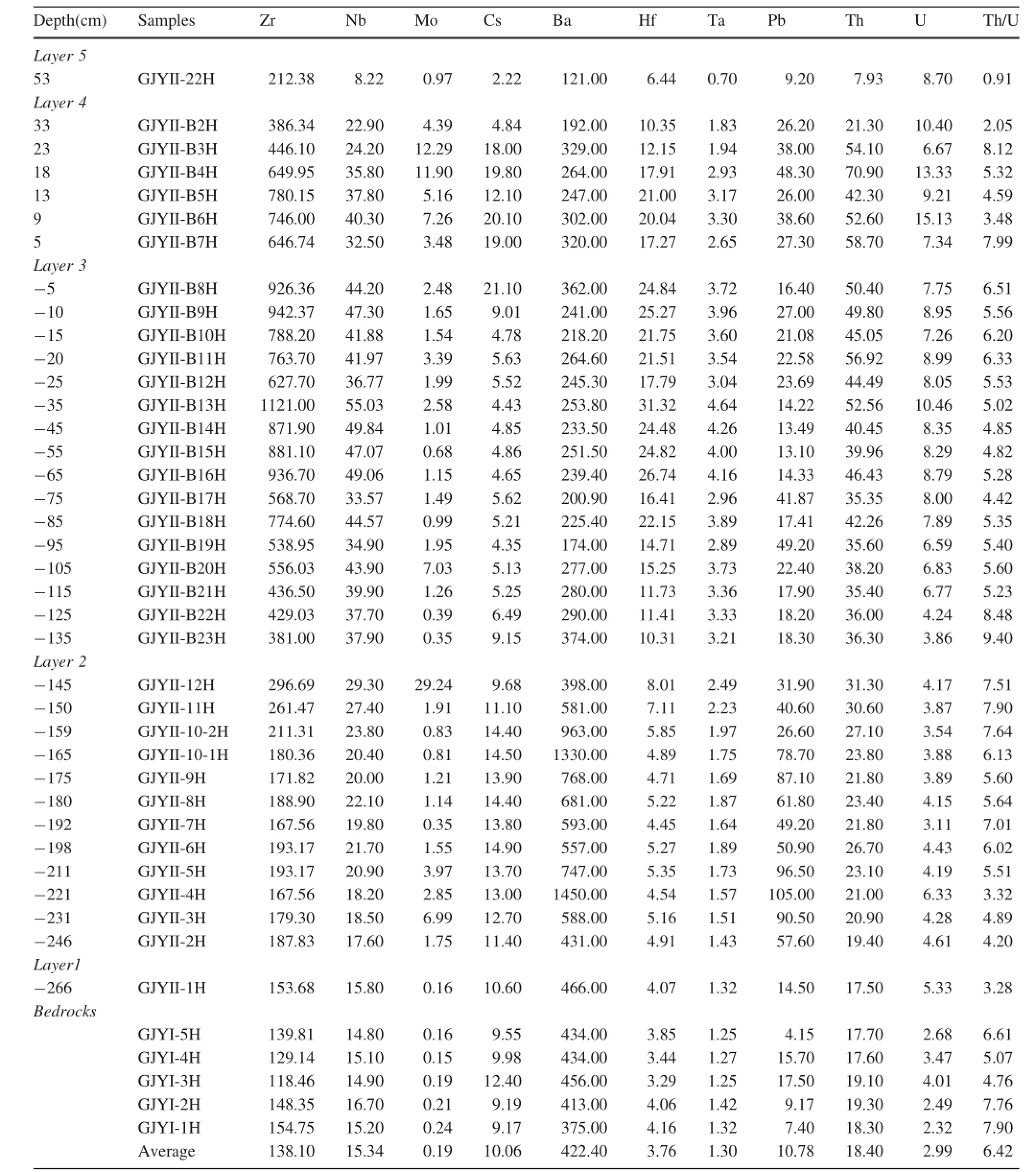
Table 2 continued

Table 3 Rare earth element contents of whole-rock samples from Gaojiayan profile

Table 3 continued

Table 3 continued
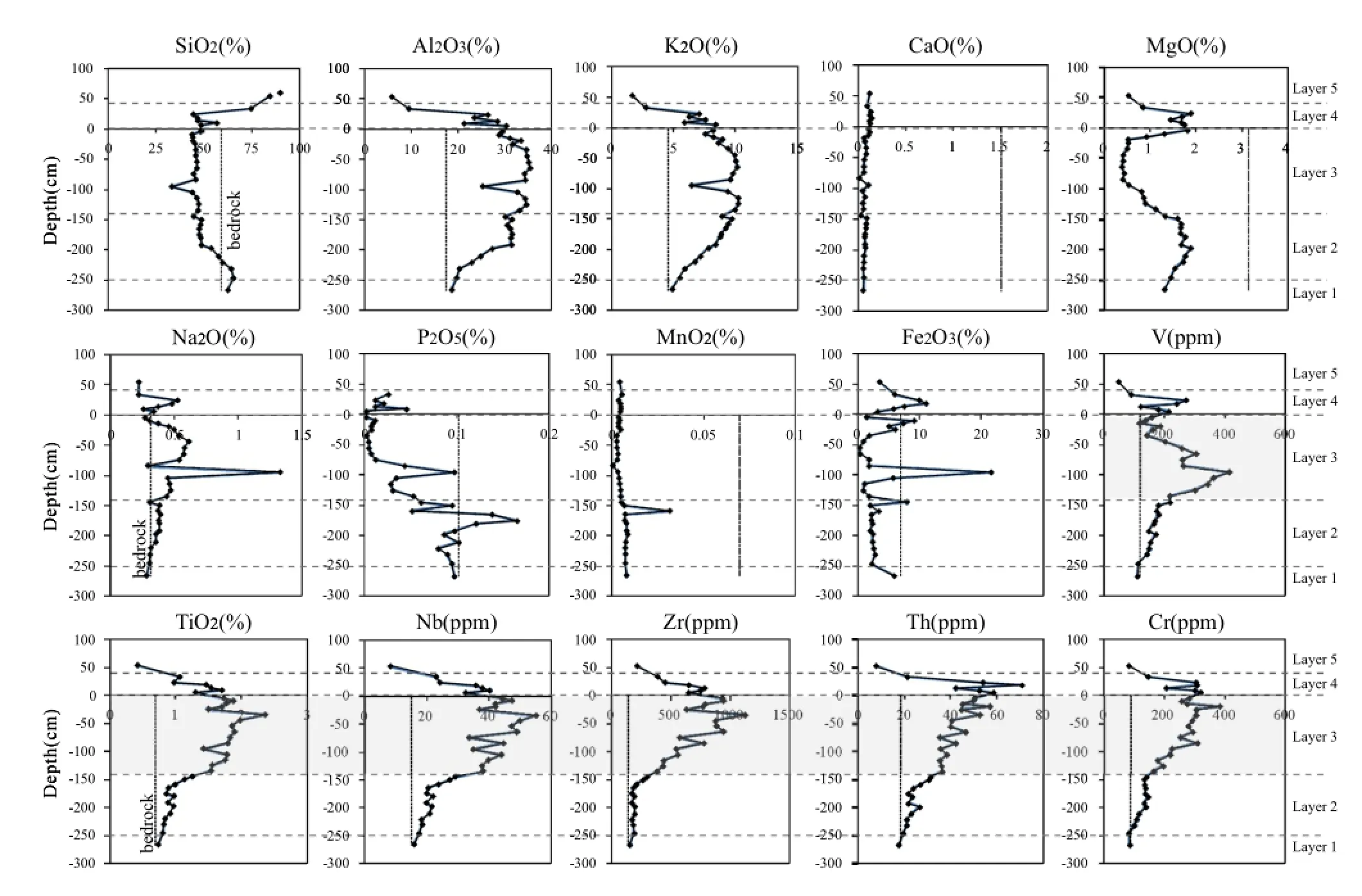
Fig.4 Major and trace element concentrations(SiO2,Al2O3,K2O,CaO,MgO,Na2O,P2O5,MnO2,Fe2O3,V,TiO2,Nb,Zr,Th,and Cr)are plotted by depth.Also plotted are the average concentrations of these elements from bedrock for comparison
column(e.g.,Little and Lee 2006).A redox proxy Ce anomaly(Ceanom)was defined by Wright et al.(1987):

where‘‘N''signifies NASC-normalized concentrations;Ceanom>-0.1isanindicationofreduction;and Ceanom<-0.1 is an indication of oxidation.In addition,Th and U are redox-sensitive elements,and Th/U is also an indicator of redox conditions(Little and Lee 2006;Chang et al.2009).Redox environments allow for Th mobility and preferential immobilization of U in the more reducing condition and Th immobility and variable behavior of U in the more oxygenated condition(Langmuir 1997).
The curves of Ceanomvariation and Th/U ratio change in the study profile present an‘‘S''shape(Fig.11).There is an increase in oxidation upward in Layer 2,but in the bottom of Layer 3 strong reduction is present.Increasing oxidation appears upward in Layer 3.Our explanation for the redox changes is that the top of Layer 2 is the surface of a previous weathering profile,and it is strongly oxidized. Layer 3 was deposited later in a reduced environment during transgression.Finally,Layer 2 with its redox characteristics is well-preserved,and the bottom of Layer 3 still conserves a relatively strong reduction.This explains the redox variation characteristics in Fig.11.
5.2 Interpretations for K and Na enrichment

Fig.5 A—CN—K (Al2O3—CaO*+Na2O—K2O)(Fedo et al.1995)triangular diagram of samples from bedrocks and Layers 1,2,3,and 4.The right trend line represents the addition of K to the Gaojiayan profile.Mineral abbreviations:Ka kaolinite,Gi gibbsite,Chl chlorite,Sm smectite,Il illite,Pl plagioclase,Ksp K-feldspar
Throughout the Gaojiayan paleosol,K2O and Na2O are relatively enriched,especially in the middle-to-upper portions(Fig.4).Generally,mobile elements such as K and Na are stronglydepletedinweatheringprofiles.Thus,wepositother geologicalprocesseswereinvolvedinthemigrationofKand Na during the evolution of the Gaojiayan paleosol.
5.2.1 K enrichment
Studies show that there are fairly common occurrences of the enrichment of K in the upper portions of paleosol(Maynard 1992;Macfarlane et al.1994a;Rye and Holland 2000;Sheldon 2003;Soil Survey Staff 1975).Some of them may result from regional metamorphism after burial(Maynard 1992;Macfarlane et al.1994a)or K metasomatism via K-rich hydrothermal fluid or other fluids(such as underground brine,ancient sea water)(Rye and Holland 2000).Furthermore,leaching from an overlying K-rich unit,derived from windborne particles of distal weathering or volcanic ash and biological processes,could also be causes for the enrichment of K in paleosols(Sheldon 2003).

Fig.6 The REE distribution patterns of paleosol samples(Layers 1,2,3,and 4)and bedrock(average of 5 samples)are presented relative to NASC

Fig.7 Plots of TiO2versus Zr,TiO2versus Al203,Nb versus Zr,and Th/Sc versus Zr/Sc for study profile

Fig.8 Zr—Cr—Ga(after Calagari and Abedini 2007 and O¨zlu¨1983),La—Th—Sc and Th—Sc—Zr/10(after Bhatia and Crook 1986)triangular diagrams of samples from the Gaojiayan profile.I,II,III,and IV correspond respectively to areas of influence of ultramafic,mafic,intermediary or argillaceous,and acidic parent rocks
The vertical distribution of K2O concentrations in the study profile(Fig.4)precludes the possibility of metasomatic addition of potassium via K-rich hydrothermal or other fluids.If metasomatic addition of potassium had taken place,thedistributionpatternofK2Owouldbesymmetrical,and the content of K2O would decrease away from the unconformity(Sheldon2003).Noevidence ofhydrothermal alteration was found in the Gaojiayan profile.During the long break in sedimentation of the Gaojiayan profile,no volcanic activity has been documented to have taken place near the study area;the possibility of the source being windborne particles or volcanic ash is minor.The content of K2O in siliceous rocks from the overlying Liangshan Fm is low,sotheenrichmentofKisnotaconsequence ofleaching from above.In order to address whether or not metamorphism has happened,we compared the behaviors of K and Rb.They are both alkali elements with similar chemical affinity,but Rb is less mobile and decouples with K2O in metasomatic settings(Mitchell and Sheldon 2009;Sheldon 2003;Sheldon and Tabor 2009).The τK2Oand τRbhave a good correlation(R2=0.77)in the studied paleosol profile(Fig.12a).Moreover,the maximum burial depth of the Gaojiayan profile is less than 1.5 km(Bureau of Geology and Mineral Resources of Guizhou Province 1987).Thus thereisnostrongregionalmetamorphismwhich wouldhave led to the enrichment of K.
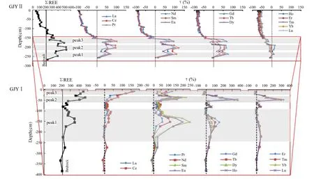
Fig.9 Depth profiles of total rare earth content(ΣREE)and their relative mass changes from study profile(GJYII)and another profile GJYI of the same horizon nearby

Fig.10 Mass change comparison of trace elements(Rb,Cs,Sc,Pb,Ta,and Th)relative to bedrock between GJYII and GJYI
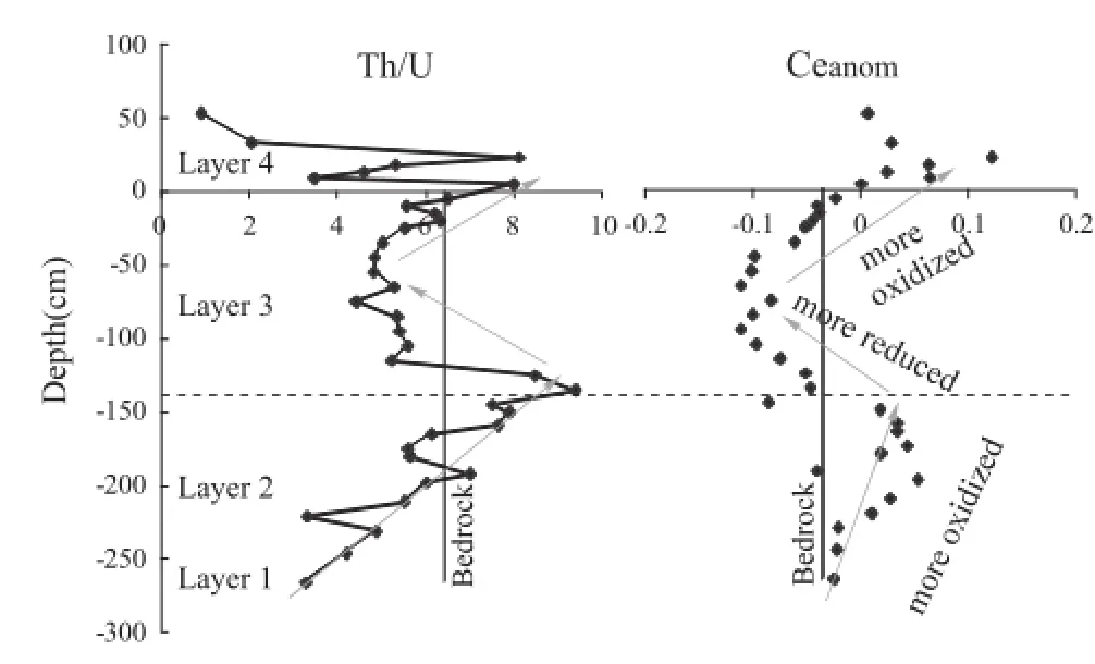
Fig.11 Depth profile of Th/U and Ce anomaly(Ceanom,after Wright et al.1987)in study profile
A possible interpretation for the enrichment of K in the Gaojiayanpaleosolisbiologicalinnature.Inthestudyprofile,thedistributionareaoffossilplantsisidenticalwiththeareaof K enrichment,and the dominant fossil plants are vascular plants(such as P.qianensis Geng)which demonstrate very high efficiency of potassium extraction from soil(Knoll and James 1987;Gill and Yemane 1999).As Rb is not a bioessential element,there is only a maximum addition of K in upper parts of Layer 2(Fig.12b),which is related to bioaccumulation and in accordance with enrichment of bio-related P2O5(Fig.4).However,biologicalprocesswasjustonefactor in redistribution of K in the profile.We believe seawater providedmostoftheKfortheGaojiayanprofileandalsomost of the Na.Based on the above analysis,we conclude that the enrichment of K in the upper portions of the Gaojiayan paleosolisacombinedresultofbiologicalprocessesandseawater intrusion,and that the latter plays a more important role.
5.2.2 Na enrichment
Boron is incorporated in fine-grained sediments in amounts proportional to the salinity of the depositional environment(Boon and Macintyre 1968).There is a double logarithm linear relationship between boron and salinity(Lendergren andCarvajal1969),namelyFreundlichadsorptionisotherm:

where B is boron uptake(ppm),S is paleosalinity(‰),and C1 and C2 are constants.Once boron is absorbed by clay minerals in the form of adsorption state or entering crystal lattices,it will not migrate with physical or chemical condition changes(Yi et al.2009).
Couch(1971)modified the equation to:

where Bkis‘‘kaolinite boron''(ppm)and equals B/(4Xi+2Xm+Xk)(B=measured boron concentration in<1 μ fraction in ppm.Xi,Xm,and Xkare weight fractions of illite,montmorillonite,and kaolinite,respectively.B is determined by X-ray diffraction);Sp=paleosalinity(‰).
Boron contents of four samples(GJYII-B14H,-B15H,-B17H,and-B22)from Layer 3 were determined at 426,594,420,and 546 ppm,respectively.Many studies support that boron content of fresh water sediment is less than 100 ppm,but that of marine sediment is generally more than 100 ppm(e.g.,Guo 1991;Chen et al.1997).
XRD data of B14H shows that the proportions of illite and montmorillonite are 87.61%and 4.01%,respectively,and no kaolinite is detected.The calculated paleo-salinity is 34.29‰.The mineral composition in Layer 3 is quite constant and dominated by illite.We assumed samples B15H,B17H,and B22 share the same mineral composition with B14H.Then calculated paleo-salinity for the samples is 44.45‰,33.92‰,41.63‰,respectively.
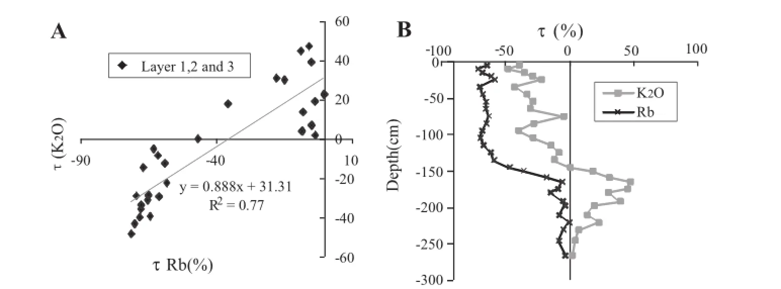
Fig.12 a The correlation diagram between τK2O(%)and τRb(%)of samples from Layer 1,2 and 3.b Comparison of relative mass change of K2O and Rb in study profile

Fig.13 Depth profile for τAl2O3(%)and τSiO2(%)in study profile
According to Blatt et al.(1980)and Jutras et al.(2009),Si is less mobile than Al in both strongly acidic(pH<4)and strongly alkaline(pH>8)conditions.This suggests that pH values of soil environment in the study profile should be 4—8 for the greater mobility of Si than Al(Fig.13).The data of Cantrell and Byrne(1987)indicate that the REEs are present as Ln(CO3)2-and LnCO3+complexes in seawater.Moreover,Wood(1990)holds that the LnCO3+complex is favored at pH values between 6.5 and 8,and/or lower dissolved carbonate concentrations,promoting greater mobility of LREEs relative to HREEs(Macfarlane et al.1994b).Thus,we suggest that the Gaojiayan profile has experienced weathering in a neutral-alkaline soil environment,which is consistent with a seawater environment diluted by fresh water.
In light of the above discussion,we propose that the formation of Layer 3 is related to transgression,and clay minerals absorbed Na+from seawater.Though some Na was leached,it is still enriched in the soil profile relative to bedrock.Other elements such as Sr,K,and Mg are also rich in seawater;however,they do not show enrichment at the same levels.They display different leaching characteristics after the second weathering.Although some of the elemental distribution characteristics have been erased,many related to transgression are still preserved.
5.3 Evolutionary model of the Gaojiayan profile
During the long break in sedimentation,the Gaojiayan profile experienced complicated evolutionary processes and was affected by paleoclimatic changes,transgression,growth of terrestrial vascular plants,and other supergene processes.A simplified evolutionary model of the Gaojiayan profile is illustrated in Fig.14.The bedrocks are silty mudstone and shales of the Hanjiadian Fm:
Stage A During the Early Silurian,the entire Yangtze Platform was affectedbythe Kwangsian Movement,and was uplifted by the end of the Telychianor possiblyin the earliest Wenlock.The Gaojiayan profile was subjected to prolonged erosionandweathering,andstarteditscomplicatedevolution.
Stage B Through long-term chemical weathering,elements were leached from upper portions and enriched in the lower,or just leached without enrichment.
Stage C The transgression happened later(Bureau of Geology and Mineral Resources of Guizhou Province 1987;Liu 1993,2001).The Gaojiayan profile(GJYII)was located in a topographic low.Weathering products re-deposited on GJYII with clay development.Seawater provided plenty of K+,Na+,and other components.At the same time,the mineral composition was dominated by illite that was stable in a neutral-alkaline soil environment.
Stage D After a brief period of transgression(Layer 2),seawater regressed.The Gaojiayan profile re-emerged and continued its weathering.
Stage E An extensive transgression happened again in the Early Permian.The top of the Gaojiayan profile was covered by a set of Liangshan Fm black siliceous rocks with basal conglomerate developing in its bottom.From then on,a burial stage followed.
Precise dating of paleo-weathering profiles still presents challenges(Sun et al.2000).To know the precise time of transgression recorded by the Gaojiayan profile,the K/Ar or40Ar/39Ar dating of illite may be a feasible method.This will be the key point of our next stage of research.
5.4 Fossil plant implication
Fossil plants are very common in the Gaojiayan paleosol. P.qianensis Geng and another plant with an irregular branching system can be recognized.It is still a controversy whether Pinnatiramosus is the earliest vascular plant or a later rooting system(Edwards et al.2007).
In this study,relative mass change of K2O(τ%)in Layer 3 was negative.P.qianensis was not found in Layer 3.Only anotherplantwithanirregularbranchingsystemwasfoundin the lower portions of this Layer,and studies show that it is of Permianage(Wangetal.2013).Strongweatheringmayhave ledtoKlossandlessplantpreservationinLayer3.Webelieve Layer 2 was exposed,too.However,the K enrichment in its top related to bioaccumulation and superior preservation of fossilplantsleadsustobelievethatP.qianensisGenginLayer 2isalsoaplantofthePermian,witharootingsystemgrowing down into lower Silurian rocks.
6 Conclusions
Detailed geochemical characteristics were investigated in the Gaojiayanpaleo-weatheringprofile fromthetownofYongle,ZunyiDistrictofGuizhou,China.Wediscusseditsformationand evolution,and the implications for the time range of P. qianensis Geng.The following conclusions were reached:

Fig.14 Evolutionary model for the Gaojiayan paleo-weathering profile.a Bedrock is silty mudstone and shale,and a—e represent idealized τ weathering trends resulting from leaching and accumulating of elements in the Gaojiayan profile.Positive τ values reflect elemental accumulation in excess of bedrock and negative values lower than in fresh rock
1.The Gaojiayan paleo-weathering profile(GJYII)is a compound paleosol profile,with Layers 1 and 2 being products of in situ weathering of the Hanjiadian Fm and Layer 3 being an allochthonous product.
2.K and Na enrichment relative to bedrock in the profile is mainly due to transgression.Seawater provides plenty of K+,Na+,and other components for the Gaojiayan profile.The growth of terrestrial vascular plants enhances the enrichment of K.
3.P.qianensis Geng is a Permian rooting system growing down into lower Silurian rocks.
AcknowledgmentsThis work was supported by the 12th Five-Year Plan Project of State Key Laboratory of Ore Deposit Geochemistry,Chinese Academy of Sciences(SKLODG-ZY125-08);funds from the State Key Laboratory of Palaeobiology and Stratigraphy,Chinese Academy of Sciences;and the National Basic Research Program of China(2007CB411408).We thank professor Shijie Wang(Institute of Geochemistry,CAS)for giving good advice before writing this paper,and also thank Xiaoyan Hu for major element analysis,Jing Hu for trace element analysis,and Guohong Gong for XRD analysis.
Appendix
See Fig.15.

Fig.15 Photos of Pinnatiramosus qianensis Geng and another plant with irregular branching system
Arndorff L(1993)Lateral relations of deltaic paleosols from the lower Jurassic Ronne formation on the island of Bornholm,Denmark. Palaeogeogr Palaeoclimatol Palaeoecol 100(3):235—250
Bhatia MR,Crook KAW (1986)Trace-element characteristics of graywackes and tectonic setting discrimination of sedimentary basins.Contrib Mineral Petrol 92(2):181—193
Blatt H,Middleton G,Murray R(1980)Origin of sedimentary rocks,2nd edn.Englewood Cliffs,Prentice-Hall
Boon JD,Macintyre WG(1968)The boron-salinity relationship in estuarine sediments of the Rappahannock River,Virginia. Chesapeake Sci 9(1):21—26
Brimhall GH,Dietrich WE(1987)Constitutive mass balance relations between chemical-composition,volume,density,porosity,and strain in metasomatic hydrochemical systems—results on weathering and pedogenesis.Geochim Cosmochim Acta 51(3):567—587
Brimhall GH et al(1988)Metal enrichment in bauxites by deposition of chemically mature aeolian dust.Nature 333(6176):819—824
Bureau of Geology and Mineral Resources of Guizhou Province(1987)Regional geology of Guizhou Province geological publishing house Beijing(in Chinese with English abstract)
Cai CY,Ouyang S,Wang Y,Fang Z(1996)An early Silurian vascular plant.Nature 379(6566):592—592
Calagari AA,Abedini A (2007)Geochemical investigations on Permo-Triassic bauxite horizon at Kanisheeteh,east of Bukan,West-Azarbaidjan,Iran.J Geochem Explor 94(1—3):1—18
Cantrell KJ,Byrne RH(1987)Rare-earth element complexation by carbonateandoxalateions.GeochimCosmochimActa51(3):597—605 Cerling TE(1992)Use of carbon isotopes in paleosols as an indicator of the carbon dioxide partial pressure of the paleoatmosphere. Global Biogeochem Cycles 6(3):307—314
Chang HJ,Chu XL,Feng LJ,Huang J,Zhang QR(2009)Redox sensitive trace elements as paleoenvironments proxies.Geol Rev 55(1):91—99(in Chinese with English abstract)
ChenZY,ChenZL,ZhangWG(1997)Quaternarystratigraphyandtrace element indicates of the Yangtze delta,eastern China,with special reference to marine transgressions.Quatern Res 47:181—191
Chen X,Rong J-Y,Wang C-Y,Geng L-Y,Deng Z-Q,Wu H-J,Xu J-T,Chen T-E(2002)Telychian rocks in the Yangtze Region.In:Holland CH,Bassett MG(eds)Telychian rocks of the British Isles and China(Silurian,Llandovery Series):an experiment to test precision in stratigraphy.National Museum of Wales Geological Series No.21,Cardiff,pp 13—43
Couch EL(1971)Calculation of paleosalinities from boron and clay mineral data.Am Assoc Pet Geol Bull 55(10):1829—1839
Driese SG,Foreman JL(1992)Paleopedology and paleoclimatic implications of Late Ordovician vertic paleosols,Juniata formation,Southern Appalachians.J Sediment Petrol 62(1):71—83
Edwards D,Yi W,Bassett MG,Sen LC(2007)The earliest vascular plant or a later rooting system?Pinnatiramosus qianensis from the marine lower Silurian Xiushan Formation,Guizhou Province,China.Palaios 22(2):155—165
Fedo CM,Nesbitt HW,Young GM(1995)Unraveling the effects of potassium metasomatism in sedimentary-rocks and paleosols,with implications for paleo-weathering conditions and provenance.Geology 23(10):921—924
Geng BY(1986)Anatomy and morphology of Pinnatiramosus,a new plant from the middle Silurian(Wenlockian)of China.Acta Bot Sin 28:664—670
Gill S,Yemane K(1999)Illitization in a Paleozoic,peat-forming environment as evidence for biogenic potassium accumulation. Earth Planet Sci Lett 170(3):327—334
Guo XP(1991)An approach to the depositional environment of the Cretaceous Kizilsu Group:the lowermost marine horizon of the Cretaceousin the western Tarim Basin.Acta Geol Sin 2:188—198(in Chinese with English abstract)
Guo Y,Li Z,Li D,Zhang T,Wang Z,Yu J,Xi Y(2004)Lithofacies palaeogeography of the Early Silurian in Sichuan area.J Palaeogeogr 6(1):20—29(in Chinese with English abstract)
Holland HD,Rye R(1997)Evidence in pre-2.2 Ga paleosols for the early evolution of atmospheric oxygen and terrestrial biota:comment.Geology 25(9):857—858
Johnson ME,Rong JY,Yang XC(1985)Intercontinental correlation by sea-level events in the Early Silurian of North-America and China(Yangtze Platform).Geol Soc Am Bull 96(11):1384—1397
Jutras P,Quillan RS,LeForte MJ(2009)Evidence from Middle Ordovicianpaleosolsforthepredominanceofalkaline groundwater at the dawn of land plant radiation.Geology 37(1):91—94
Knoll MA,James WC(1987)Effect of the advent and diversification of vascular land plants on mineral weathering through geologic time.Geology 15(12):1099—1102
Kraus MJ(1999)Paleosols in clastic sedimentary rocks:their geologic applications.Earth Sci Rev 47(1—2):41—70
Kurtz AC,Derry LA,Chadwick OA,Alfano MJ(2000)Refractory element mobility in volcanic soils.Geology 28(8):683—686
Lander RH,Bloch S,Mehta S,Atkinson CD(1991)Burial diagenesis of paleosols in the Giant Yacheng gas-field,Peoples-Republicof-China—bearing on Illite reaction pathways.J Sediment Petrol 61(2):256—268
Langmuir D(1997)Aqueous environmental geochemistry,vol 1. Prentice Hall,Upper Saddle River
Lendergren S,Carvajal MC(1969)Geochemistry of boron.III.The relationship between boron concentration in marine clay sedimentsandthesalinityofthedepositionalenvironments expressed as an adsorption isotherm.Arkiv Mineralogioch Geologi 5:13—22
Li Y,Rong J(2007)Shell concentrations of Early Silurian virgianid brachiopods in northern Guizhou:temporal and spatial distribution and tempestite formation.Chin Sci Bull 52(12):1680—1691
Liao SHF(1999)Some advances in study of sedimentary deposits. GuozhouGeol16(2):122—135 (inChinesewithEnglish abstract)
Little MG,Lee CTA (2006)On the formation of an inverted weathering profile on Mount Kilimanjaro,Tanzania:buried paleosolorgroundwaterweathering?ChemGeol 235(3—4):205—221
Liu P(1993)An additional discussion on bauxite deposit of Guizhou(III)—their metallogenetic epoch,material source and metallogenetic model.Guozhou Geol 10(2):105—113(in Chinese with English abstract)
Liu P(2001)Discussion on the metallogenic setting of the Qianzhong-Yu'nan bauxite in Guizhou and Its genesis.Guozhou Geol 18(4):238—243(in Chinese with English abstract)
Macfarlane AW,Danielson A,Holland HD(1994a)Geology and major and trace-element chemistry of late archean weathering profiles in the Fortescue Group,Western-Australia—implications for atmospheric P-O2.Precambr Res 65(1—4):297—317
Macfarlane AW,Danielson A,Holland HD,Jacobsen SB(1994b)REE chemistry and Sm-Nd systematics of late archean weatheringprofilesintheFortescue-Group,Western-Australia. Geochim Cosmochim Acta 58(7):1777—1794
Marques JJ,Schulze DG,Curi N,Mertzman SA(2004)Trace element geochemistryinBrazilianCerradosoils.Geoderma 121(1—2):31—43
Maynard JB(1992)Chemistry of modern soils as a guide to interpreting precambrian paleosols.J Geol 100(3):279—289
Mitchell RL,Sheldon ND(2009)Weathering and paleosol formation inthe1.1 GaKeweenawanRift.PrecambrRes 168(3—4):271—283
Nesbitt HW(1979)Mobility and fractionation of rare-earth elements during weathering of a granodiorite.Nature 279(5710):206—210
Nesbitt HW,Markovics G,Price RC(1980)Chemical processes affecting alkalis and alkaline earths during continental weathering.Geochim Cosmochim Acta 44(11):1659—1666
O¨zlu¨N(1983)Trace-element content of‘‘Karst Bauxites''and their parentrocksinthemediterraneanbelt.MinerDeposita 18(3):469—476
Retallack G(1988)Field recognition of paleosols.Geol Soc Am Bull 216:1—20
Retallack G,Mcdowell P(1988)Penrose conference report—paleoenvironmentalinterpretationofpaleosols.Geology 16(4):375—376
Riebe CS,Kirchner JW,Finkel RC(2004)Erosional and climatic effects on long-term chemical weathering rates in granitic landscapes spanning diverse climate regimes.Earth Planet Sci Lett 224(3—4):547—562
Rong J-Y,Johnson ME,Yang X-C(1984)Early Silurian(Llandovery)sealevel changes in the Upper Yangtze region of central and southwestern China.Acta Palaeontol Sin 23:687—697
Rong J,Johnson ME,Zhao Y(1996)Geological significance of an ancient karst rocky shoreline—a case study of an Early Silurian rocky shoreline in Guizhou.Geol Rev 42(5):448—459(in Chinese with English abstract)
Rye R,Holland HD(2000)Geology and geochemistry of paleosols developed on the Hekpoort basalt,Pretoria Group,South Africa. Am J Sci 300(2):85—141
Sheldon ND(2003)Pedogenesis and geochemical alteration of the Picture Gorge subgroup,Columbia River Basalt,Oregon.Geol Soc Am Bull 115(11):1377—1387
Sheldon ND,Tabor NJ(2009)Quantitative paleoenvironmental and paleoclimatic reconstruction using paleosols.Earth Sci Rev 95(1—2):1—52
Sheng ZQ,Liao LP(2010)Sedimentary mode and mineralization of sedimentary bauxite deposit of fossil weathering crust in Guizhou.Guizhou Geol 27(4):255—259(in Chinese with English abstract)
Soil Survey Staff(1975)Soil taxonomy:A basic system of soil classification for making and interpreting soil surveys.United States Department of Agriculture Soil Conservation Service,Washington,DC
Soreghan GS,Elmore RD,Katz B,Cogoini M,Banerjee S(1997)Pedogenically enhanced magnetic susceptibility variations preserved in Paleozoic loessite.Geology 25(11):1003—1006
Sun CX,Wang SJ,Liu XM,Ji HB(2000)Review on the dating of the weathering profiles.Bull Mineral Petrol Geochem 19(1):54—59(in Chinese with English abstract)
Tandon SK,Sood A,Andrews JE,Dennis PF(1995)Paleoenvironments of the dinosaur-bearing lameta beds(Maastrichtian),Narmada valley,Central India.Palaeogeogr Palaeoclimatol Palaeoecol 117(3—4):153—184
Wang Y,Edwards D,Bassett M,Xu H,Xiao J,Jiang Q,Zhang X(2013)Enigmatic occurrence of Permian plant roots in lower Silurianrocks,GuizhouProvince,China.Palaeontology 56(4):679—683
Webb GE(1994)Paleokarst,paleosol,and rocky-shore deposits at the Mississippian-Pennsylvanianunconformity,northwestern Arkansas.Geol Soc Am Bull 106(5):634—648
Wood SA (1990)The aqueous geochemistry of the rare-earth elements and yttrium.1.Review of available low-temperature data for inorganic complexes and the inorganic REE speciation of natural-waters.Chem Geol 82(1—2):159—186
Wright J,Schrader H,Holser WT(1987)Paleoredox variations in ancient oceans recorded by rare-earth elements in fossil apatite. Geochim Cosmochim Acta 51(3):631—644
Yi HS,Shi ZQ,Zhu YT,Ma X(2009)Reconstruction of paleosalinity and lake-level fluctuation history by using boron concentration in lacustrine mudstones.J Lake Sci 21(1):77—83(in Chinese with English abstract)
Zhang C,Nie RZ(2006)Silurian sequence stratigraphic framework and the pre-analysis of petroleum exploration in northern Guizhou Province.Xinjiang Geol 24(2):161—164(in Chinese with English abstract)
Zhu Z,Chen H,Liu L,Hou M,Chen A,Zhong Y(2010)Depositional system evolution characteristics in the framework of sequences of silurian and prediction of favorable zones in the northern GuizhousoutheasternSichuan.ActaSedimentolSin 28(2):243—253(in Chinese with English abstract)
10.1007/s11631-015-0070-6
24 June 2014/Revised:23 July 2015/Accepted:24 August 2015/Published online:8 October 2015
✉ Jia-fei Xiao
xiaojiafei5@163.com
1State Key Laboratory of Ore Deposit Geochemistry,Institute of Geochemistry,Chinese Academy of Sciences,Guiyang 550002,China
2Chinese Academy of Geological Sciences,Beijing 100037,China
3Chengdu Institute of Geology and Mineral Resources,Chengdu 610083,China
4Nanjing Institute of Geology and Palaeontology,Chinese Academy of Sciences,Nanjing 210008,China
©Science Press,Institute of Geochemistry,CAS and Springer-Verlag Berlin Heidelberg 2015
杂志排行
Acta Geochimica的其它文章
- Chemical weathering and CO2consumption of a high-erosion-rate karstic river:a case study of the Sanchahe River,southwest China
- Identification of the four rearranged hopane series in geological bodies and their geochemical significances
- Geochemical and geochronological studies of the Aketas granite from Fuyun County,Xinjiang:the implications of the petrogenesis and tectonic setting
- Characterization of biochars produced from seven biomasses grown in three different climate zones
- Research on the ecological risk of heavy metals in the soil around a Pb-Zn mine in the Huize County,China
- Fluorite REE characteristics of the Diyanqinamu Mo deposit,Inner Mongolia,China
