Land Use Structure in Wuhai City on Basis of Ecological Green Equivalence
2015-02-05PingLITaisenSUN
Ping LI,Taisen SUN
1.College of Resources&Environmental Sciences,Shanxi Agriculture University,Taigu 030801,China;
2.Research Center of Environmental Sciences and Engineering,Shanxi University,Taiyuan 030006,China
Land Use Structure in Wuhai City on Basis of Ecological Green Equivalence
Ping LI1,2,Taisen SUN1*
1.College of Resources&Environmental Sciences,Shanxi Agriculture University,Taigu 030801,China;
2.Research Center of Environmental Sciences and Engineering,Shanxi University,Taiyuan 030006,China
The paper took Wuhai District as an example,bases on the contrast between the land use condition in 2005 and 2010,and applied the ecological green equivalence to establish a mathematic model of ecological optimization of land use structure,to establish the ecology green equivalent mathematical model and survey the value of region green equivalent,and then assess the ecological environment situation.The results show that the ecological environment has been deteriorated in Wuhai from 2005 to 2010,so the ecological environment was poor.In order to increase eco-efficiency of land use,garden,urban green space and woodland area should be raised in the optimization program.
Ecological green equivalence;Forest coverage rate:Land use structure; Wuhai city
L ands are comprehensive resources,laying foundation for human existence and development,and the issue of land is a social fundamental problem can never be ignored[1].A city is a product of human civilization and social and economy development,relying on lands[2].It is, therefore,a hot issue in academic fields for accomplishing sustainable use of lands and improving urban ecosystem services to research rationality and optimization methods of land sue structure[3-4].The research established ecological green equivalence model to explore land use structure and optimization in a quantitative way from the perspective of ecological services.
Research Method
The concept of ecological green equivalence
With advancement of urbanization,it is inevitable for negative effects to produce on natural ecosystems,affecting regional sustainable development.In order to make compensation on the weakened ecological functions of forests,it is necessary to the ecological function of"equivalent and the term of green equivalence is proposed accordingly.Specifically,green equivalence includes equivalent photosynthesis and regional ecological functions,meaning restoring original equivalent photosynthesis to compensate the ecological role which could have played by the plants.It can be concluded that green equivalence is the green quantity of rest vegetations-to-green quantity of the equivalent forests[5].In general,green equivalence is measured according to an ecological type as per forest ecolo gi cal functions[6-9]and it is believed that lands with green equivalence include forest lands,farmlands and grasslands.
Land classification based on ecological green equivalence
In accordance with ecological green equivalence and land use patterns in Wuhai City,lands can be classified into the following categories:the lands with green equivalence and can be quantified,including farmlands, garden plots,forest lands,grass lands, rest agricultural lands,and urban green lands;the lands with green equivalence but hardly be quantified, including arsh,beach,pond,Reservoir
Estimation Methods of Ecological Green Equivalence
Data source
The research data were fromWuhai City Statistical Yearbook,A General Plan of Land Use in Wuhai Cityduring 2006-2020 and resources provided by Ministry of Land and Resources of Wuhai City.
Calculate the effect value of various ecosystems
Selection and quantification of indicesUrban lands are a complex ecosystem of nature,economy and society,laying foundation for production, living,logistics,and transportation for people.Currently,however,lots of farmlands are occupied resulting from urbanization and industrialization, leading to declining of land ecological services.What’s worse,the reducing of ecological lands affects not only social sustainable development,but also crop safety,eco-health and ecosecurity,posing threats to human beings[10-12].The introduction of ecological green equivalence theory to optimization of land use structure aims at determining the minimum ecological standard and guaranteeing basic ecological lands according to local natural and environment evolvement.Therefore, the chosen indices should reflect regional protection,benefiting and adjustment in terms of nature,society and economy environments. The research used the assessment value sheet concluded by Japanese experts[13]and summed up the assessment value sheet on eco-environment protection(Table 1)with consideration of natural conditions and land use.

Hence,it can be concluded that the ecological function service totaled 150.95 of forest lands,99.22 of farmlands,107.84 of garden plots,112.12 of grasslands,91.06 of urban green lands and 131.95 of water.
Average ecological green equivalence of different land typesIn accordance with eco-environment functions of different land types,assuming green equivalence of forestlands was 1,X=Fi/Fforestland,involvingXas the ecological green equivalene of theithtype land,Fias total score of ecological services of theithland,Fforestlandas total score of ecological services of forestlands,it can be concluded that green equivalence values of forestland at 1.0,farmlands at 0.66, garden plots at 0.71,grasslands at 0.74,urban greenlands at 0.60,and water at 0.87.Nevertheless,considering the differences of climate and soils, the green equivalence of the same land type tended to be volatile upon regions.In the research,the measurement of green equivalence of different land types should consider the growth term(the coefficient of growth term in a year=the length of growth term(m)/12)and cropping system(the value of regional cropping system and crop growth term).In other words,the practical green equivalence of local ecosystem is a product of green equivalence of different lands multiplying growth term in a whole year[11](Table 2).
Wuhai City has a temperate continental climate and crops are grownas per single cropping system,and the growth term coefficient was 0.46 in a whole year.It can be concluded that average green equivalence values in a year were 0.3 of farmlands,0.34 of garden plots,and 0.33 of grasslands, and the rest values were the same as those computed above.

Table 1Assessment values of environment protection functions of ecosystems
Calculation of regional ecological green equivalenceGiven regional area was Stotal,the regional area with optimal forest coverage rate was Sforestland,regional practical area of forestland was Spratical,the area of the ith land was Si,green equivalence was gi,and i represented the type of lands, the following model can be concluded:
Sforestland=Stotal×R,the green equivalence x was=1;
Urban practical forestlands green equivalence Xforestland=Spratical/Sforestland× 100%;

Urban ecology can be evaluated as per the values of x and x.Specifically,x≥x,the standard can be met, or land use structure is required to be adjusted.After adjustment,calculation should be repeated to seek a rational land use optimized model.
It is notable that the urban greenland coverage rate was determined as per optimal forest coverage rate[14].

Table 2Green equivalence of farmlands and grasslands in a whole year
R=(P×Si)/(W×Stotal),where Stotal refers to total area of regional lands (hm2);P refers to maximal precipitation per year(t/hm2);Si=Stotal-(the areas of construction,mining,transportation, water conservancy lands)(hm2);W refers to water-holding capacity of forestlands(t/hm2).
Measurements and Analysis of green equivalence in Wuhai City
Introduction of research area
Wuhai City is a mining city in the west of Inner Mongolia.Located in upper reaches of the Yellow River,it borders Ordos deserts in the east, Alashan Plateau in the west,Yinchuan Plain in the south and Hetao Plain in the north at 106°36′-107°5′E and 39°15′-39°52′N,with average elevations of 1 150 m.With an area of 1 754 km2,Wuhai City has usable lands of 1 282 km2,including arable lands of 200 km2,without consideration of high mountains or bare lands.At present, 70 km2agricultural lands have been exploited and construction lands in the city reach 55.8 km2.Wuhai City is situated in innerland and has a continental climate,characterized by few snows in winter,dry climate in spring,hot in summer and cool in autumn.The annual mean precipitation is 159.8 mm. The Yellow River flows through 105 km in the city,and average width reaches 250-500,with depth of 2.5-11.6 m and perennial mean runoff of 26.9 billion m3.Wuhai City is divided into three districts,Haibowan District, Hainan District,and Wuda District.The population is 550 000.
Use of lands in the research area
As shown in Table 3,land areas in different uses changed significantly during the five years in Wuhai City,of which water conservancy lands changed the most,increasing by 1 423.6 hm2in total,and forestlands also increased by 2 000 hm2.In general,most lands kept growing,except of farmlands.
Calculation of ecological green equivalence in the research area
According to Wuhai Meteorological Bureau,Ministry of Land and Resources and Bureau of Statistics,as well as the optimal forest coverage rate of Wuhai City,maximal precipitation was given 990.5 t/hm2in a year, water-holding capacity of forestlands reached 1 904.22 t/hm2per unit area[15]. Furthermore,the best green land coverage rate can be concluded as per previous calculation methods.Crops in Wuhai City were as per single cropping system,and it can be concluded the green equivalence of farmlands was 0.35 and of grasslands was 0.34. As shown in Table 3 and Table 4,regional green equivalence can be computed.
As shown in Table 4,the ecological green equivalence values in 2005 and 2010 were both lower than 1. Compared with 2005,the equivalence value in Wuhai in 2010 increased a little,and eco-environment improved, but ecological green equivalence still kept below 1,which suggested that regional eco-environment is poor.

Table 3Land uses in Wuhai City in 2005 and 2010
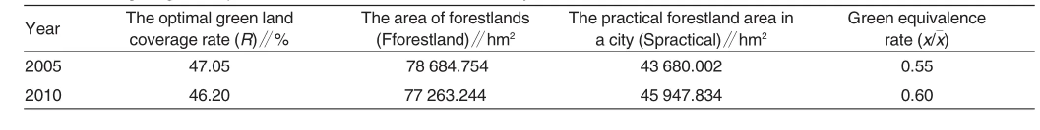
Table 4Ecological green equivalence in 2005 and 2010 in Wuhai City
The optimization scheme of land use structure
As per A General Plan of Land Use in Wuhai City during 2006-2020 and A General Plan of Wuhai City in 2011-2030,land use structure should be adjusted to optimize ecological service function in Wuhai City,with consideration of land supply and demand in a well-coordinated way.Specifically, as far as land use in Wuhai be concerned,land use structure is hard to be well adjusted in a short term,and land use patterns change little.Therefore,it is necessary to implement afforestation,and extending green lands.For instance,a“green line”can be set,covering urban park,street green lands,greenbelts,nurseries and flower nurseries;large-scale forestlands,water,or wetlands,nature reserve,or other regions playing an active role in urban eco-environment. Besides,green belts can be arranged along the Yellow River,Gandeer River,Bayinsai River,and Nanhecao,or roads in cities,as well as the Beijing-Tibet Expressway and Baotou-Lanzhou Railway.Additionally,green lands should be increased in parts in urban districts.On the other hand,it becomes crucial to intensify land consolidation and reclamation in mining areas.According to statistic works,the lands ready for consolidation(740.22 hm2)or reclamation(1 218.30 hm2)are mainly distributed in Lasengmiao Town,Hainan District,Suhaitu Office and Liangjiagou Office,Wuda District. Therefore,it is of necessity to reinforce land consolidation and reclamation and to take engineering and biological measures in order to restore and improve eco-environment in mining zones and enhance land use rate.
Through optimization and adjustment,it can be computed that the ecological green equivalence(x)was 1.021.When x/x>1,ecological standards can be met and eco x environment be optimized.
Conclusions
On basis of forest coverage rate of ecological green equivalence,different eco-oriented lands were analyzed,especially for ecological service function of farmlands,garden plots and urban green lands,and land use structure in Wuhai City was analyzed and optimized with consideration of number and space,improving land use science and maneuverability. With serious environment problems,it is urgent to make full use of land ecological service functions and improve regional environment capacity to reach economic,social and environment coordinated development.However,the application of ecological green equivalence in reflecting regional eco x environment quality is still limited,for unused lands and water can not be quantified.
[1]CAI YL(蔡云龙).Land use/cover change: to explore new comprehensive ways(土地利用/土地覆被变化研究:寻求新的综合途径)[J].Geographical Research(地理研究),2001,20(6):645-652
[2]HUANG XJ(黄贤金).Changes and response of urban land us:model construction and empirical research(城市土地利用变化及其响应:模型构建与实证研究)[M].Science Press(科学出版社). 2008.
[3]DAILY G C,POLASKY S,GOLDSTEIN J,KAREIVA P M,MOONEY H A,PEJCHAR L,RICKETTS T H,SALZMAN J,SHALLENBERGE R.Ecosystem services in decision making:time to deliver.Frontiers in Ecology and the Environment,2009,7(1):21-28.
[4]TAKEBAYASHI H,MORIYAMA M.Surface heat budget on green roof and high reflection roof for mitigation of urban heat island.Building and Environment, 2007,42(8):2971-2979.
[5]http://baike.haosou.com/doc/5189845. html
[6]KUANG LY(邝笠塬),RUAN XL(阮心玲).The application of ecological green equivalent on land use structure optimization and example(基于生态绿当量的开封土地利用研究)[J].Heilongjiang Environmental Journal(黑龙江环境通报),2009,33(3):11-13.
[7]NI L(倪琳),ZHOU Y(周勇),LIU Y(刘义),et al.A case of Qianjiang city:land utilization structure optimization based on ecological green equivalent(基于生态绿当量的土地利用结构优化研究——以湖北省潜江市为例)[J].Resources& Industries(资源与产业),2008,10(4): 50-53.
[8]LIU YJ(刘远君),MA HL(马会玲),MA YG (马扬敢).Assessment on the effects of land use changes on environment in Meizhou city based on ecological green equivalence(基于生态绿当量的梅州市土地利用变化环境影响评价)[J].Southern Horticulture(南方园艺),2009,20(2): 34-36.
[9]ZHENG QY(郑群英),ZHOU SL(周生路),REN K(任奎).An eco-efficiency measurement method of land use structure optimization:a case study in Jiangning district of Nanjing city(土地利用结构优化生态效益考量方法研究——以南京江宁区为例)[J].Resources Science(资源科学),2009,31(4):634-640.
[10]LI F(李锋),WANG RS(王如松). Method and practice for ecological planning of urban green space-Yangzhou city as the case study(城市绿色空间生态规划的方法与实践—以扬州市为例)[J].City Environment And City Ecological(城市环境与城市生态), 2003,16:46-48.
[11]ZHANG DP(张德平),LI DZ(李德重), LIU KS(刘克顺).Ecological land crucial in land planning(规划修编,别落了生态用地)[J]China Land(中国土地), 2006,(12):26-27
[12]DENG HB(邓红兵),CHEN CD(陈春娣),LIU T(刘听),et al.Concepts and classification of regional ecological lands(区域生态用地的概念和分类)[J] .?Acta Ecologica Sinica(生态学报), 2009,3;1519-1524.
[13]MAO WY(毛文永).Assessments of eco-environment’s effects(生态环境影响评价概论)[M].Beijing:China Environmental Science Press(北京:中国环境科学出版社),1998.
[14]GONG YB(宫渊波),ZHANG J(张健), CHEN LW(陈林武).Study on forest coverage of the optimum forest protective effect of a country(四川盆地低山丘陵区县级最佳防护效益森林覆盖率定量研究)[J].Journal of Sichuan Agricultural University(四川农业大学学报), 1996,14(2):231-236.
[15]GUO CF(郭城峰),QIN FC(秦富仓), YUE YJ(岳永杰).Study on water storage ability of forest soil in watershed in Aohan county(敖汉旗小流域典型林地土壤蓄水能力研究)[J].Inner Mongolia Forestry Science and Technology(内蒙古林业科技),2009,35(2):6-9
Responsible editor:Xiaoxue WANG
Responsible proofreader:Xiaoyan WU
基于生态绿当量的乌海市土地利用结构研究
李萍1,2,孙泰森1*
(1.山西农业大学环境与资源学院,山西太谷030801;2.山西大学环境科学研究所,山西太原030006)
基于生态绿当量的理论,构建土地利用结构模型,利用乌海市2005年和2010年土地利用现状数据,测算出乌海市各种用地类型的绿当量和区域总绿当量,用以分析生态环境现状。分析结果表明:①2005年、2010年乌海市生态绿当量都小于1,生态环境较差;②优化方案需要通过林地、园地、城市绿地及绿化带的增加来提高土地利用生态效益。
生态绿当量;森林覆盖率;土地利用结构;乌海市etc.the lands without green equivalence,involving living space,warehouse land,industrial and mining area, transportation land,land use of irrigation works and some unused lands.
李萍(1975-),女,山西朔州人,讲师,在读博士生,主要研究土地利用与环境影响,E-mail:liping0349@163.com。*通讯作者。
2015-04-04
修回日期 2015-05-14
*Corresponding author.E-mail:liping0349@163.com
Received:April 4,2015 Accepted:May 14,2015
猜你喜欢
杂志排行
Agricultural Science & Technology的其它文章
- Analysis and Discussion on Some Problems of the Edible Fungi Production in Asmara Area
- The Control Research Progress ofLiberobacter asiaticumin Taizhou City
- Application of Genetically Modified Technology in Maize Breeding
- Breeding of Indica Rice CMS Line Renong 1A with Virescent-yellow Leaf
- Breeding and Application of Indica PTGMS Line Yan 161S and Its Hybrid Yanliangyou 1618 in Rice
- Thoughts on the Sustainable Development of the Fava Bean Industry in Chongqing