Multiscale Regional Formula Fertilization Considering Environment Information Incompleteness
2015-02-05QianqianZHANGYanLIANG
Qianqian ZHANG,Yan LIANG
College of Resources and Environment,Shanxi Agricultural University,Jinzhong 030801,China
1 Introduction
Cultivated land,as a kind of important farming landscape,not only provides plenty of means of agricultural production to people,but also has great influence on conservation of water resource,regulation of climate and maintenance of biodiversity[1].However,human activities are becoming gradually frequent,only emphasizing value of agriculture production,which has been amain factor leading to damage of cultivated land[2].Although it is necessary to improve cultivated land productivity by applying fertilizer,blind and excessive application of fertilization in country has resulted in increase of cost and profligacy as well as environment pollution in recent years.Cultivated land is a geography complex formed under certain conditions,and it will be affected by climate,topography,water,farming methods and so on,so spatial variety exists in cultivated land productivity[3].To apply fertilization according to evaluation of cultivated land productivity has a great impact on sustainable development of agriculture,while utilization of fertilizer will be improved,production cost reduced,and ecological environment protected and income of farmers increased[4].Overseas researches concerning formula fertilization mainly place emphasis on recommending formula fertilization by soil or plant testing:balanced fertilization.Data of nutrient will be obtained by using soak,and the rate of nutrient will be defined according to the index[5].Researchers abroad have an orientation toward the system of formula fertilization by testing soil[6-8].Studies in this field are much backward in China.Scholars tend to explore from several angles like evaluation strategy of cultivated land productivity and identification of formula fertilization through developing formulation to calculate the cultivated land productivity and fertilizing rate with empirical method[9-14].The research range is narrow and it is mainly focused on cultivated land at county level.Although some researchers have developed regional fertilizer formula based on evaluation of cultivated land in grand area according to AHP(Analytic Hierarchy Process)[15],AHP is stillnotavailable to decide the fertilizer rate in various regions,due to the demand of large experiment data.But great progress has been made in establishing special information system by using GIS technology to study cultivated land.Some scholars take wetland in Songnen Plain as a study object and establish a database.GIS technology is adopted to develop wetland information system of Songnen Plain,and information of cultivated land can be operated:query,modification,count and visualizing analysis[16].What's more,cultivated land management system of Yongji City in Shanxi Province has been established through the coupling of MapGIS and AHP[17].Study concerning fertilization decision system combined with expert knowledge and spatial data of cultivated land has gradually become hot issue.Some formula fertilization expert systems meeting local actual conditions have been developed:vegetable fertilization expert system of Shanxi Academy of Agricultural Sciences[18],Karst County formula fertilization by soil testing expert system software of Guizhou Academy of Agricultural Sciences[19],Mengcheng County formula fertilization by soil testing expert decision system of Anhui Agricultural University[20].Formula fertilization units of traditional cultivated land evaluation are the outcome of soil experts' work-administrative division at county level,present land-use map and soil map are overlaid together[21].Then soil experts' experiential knowledge of soil and environment is included.During the process of evaluating cultivated land productivity with traditional formula fertilization,soil experts will establish empirical models about the relation between land and landscape through field survey,and then they will interpret the aerial photographs or satellite photos with the help of topographical maps and geological maps,to recognize landscape units with specific environment features.Finally,fertilization units corresponding with special landscape will be outlined by hand.Therefore,fertilization units in traditional cultivated land productivity classification map have some correspondence with landscape which corresponds with multiple environment factors in certain areas.Conversely,environment factors have different impact on cultivated land productivity in various areas.Researches of cultivated land productivity evaluation and formula fertilization mainly focus on evaluation of block in county at present.As parameters for different blocks are different,it prevents different evaluation results from being comparable,which can not meet application requirement of cultivated land productivity evaluation and fertilization among various regions.At the same time,researches of information system for cultivated land emphasize the data of cultivated land,display,management,and query and statistical analysis.Few of systems have thematic features of cultivated land geographic assessment and formula fertilization,but still remain at the level of classifying thematic data.Both researches of cultivated land productivity evaluation and formula fertilization and researches of information system for cultivated land have their limitation with incomplete cultivated land environment information,and there is little literature concerning regional formula fertilization with incomplete environment information in traditional cultivated land productivity evaluation and establishment of Multiscale Optimizing Formula Fertilization(MSOFF).Under these circumstances,this paper is aimed at the establishment of MSOFF based on multiscale regional formula fertilization considering incomplete environment information.
2 Multiscale regional fertilization models
2.1 Introduction of multiscale regional fertilization modelsMultiscale regional fertilization models mainly consist of two sub-models:multiscale cultivated land productivity model and formula fertilization model.In the paperBuilding Multiscale EGLSN System and Simulating Cultivated Land Productivity[22],it is said that multiscale cultivated land productivity model counts yield at county level to represent regional productivity of maize.Under this circumstance,incomplete environment information,as an impact factor which affects cultivated land productivity,is necessary,and five factors are involved:eco-climate,morphologic landscape,measure of land utilization,soil condition and nutrient management.On the other hand,regional formula fertilization model defines the rate of fertilizer application with target unit-of-output method,and target unit-of-output is determined by cultivated land productivity model which needs two parameters:amount of water taken into permaize and regional soil utilization rate.
2.2 The establishment of regional multiscale cultivated land productivity modelWith the coupling of GIS and EGLSN model,soil map is overlaid with land use map to act as base map,and units are formed.These units become the basic units to establish regional multiscale cultivated land productivity model.The establishment of multiscale regional cultivated land productivity model is based on the perfect aggregation theory about the study of population regional distribution and scaling up application.Two main steps are included:collection of general data and pretreatment of datasets with spatial join;analog computation and presentation of multiscale regional cultivated land productivity based on overlaid units.The detailed process is shown in Fig.1.
2.2.1 Data sources.The research region is Shanxi Province,between latitude 34°34′N to latitude 40°44′N and longitude 110°14′E to longitude114°33′E.It is a typical loess region,and maize is the staple of the area.Data collected include meteorological data,soil data,land form data,soil experimental data of sampling point,agricultural statistics and so on.Meteorological data is the source of meteorological observation data provided by Weather Bureau of Shanxi Province.There are 108 meteorological stations(one station at the county level on average,and Wutai County has two due to its unique landform),and data of frost-free period,minimum air temperature,rainfall and≥10℃ accumulated temperature(2004a-2005a).National digital soil map and soil database are obtained by HWSD while soil property data are obtained by analyzing thickness of the topsoil,soil texture,soil salinization and so on.Digital geomorphologic map comes from landform division map of Shanxi Province provided by College of Resource and Environment,Shanxi Agricultural University while soil experimental data of sampling points are from formula fertilization by soil testing subsidies project data provided by Station of Soil and Fertilizer,Shanxi Agricultural Department.Shanxi Statistic Bureau has provided the data of maize management in Shanxi fromStatistical Yearbook of Rural Areas at County-level,and the data of yield of maize in Shanxi fromStatistical Yearbook of Shanxi Province.
2.2.2 Data pretreatment.Basic spatial data collected are incom-plete for many technical and financial reasons,for example,meteorological data coming from separate stations lead to boundary inconsistency of pictorial data vectorization.This paper analyzes the regional simulation.Soilmap and land use map are overlaid to be base map,and units are formed.Before the regional simulation,pretreatment is needed for the spatialization of environmental data mentioned above like meteorological data,landform data and soil data by GIS and database technology.As original meteorological data are collected in the form of stations,these data are needed to be processed to finish spatial interpolation with inverse proportion weighting method by using GIS and database technology,to reach spatialization.Then the grid layer formed with spatial interpolation and base map are overlaid,and element identity becomes basis for units to make an enquiry,so that meteorological data of each unit can be inquired.With weighted average method,the data after being overlaid is meteorological property of the unit.After Shanxi Landform Division Map is vectorized,it can be overlaid with base map in ArcGIS.Then landform information of simulated unit will be identified by handling overlaid data according to Area-dominant Method.Soil property of Shanxi soil finally is attached to base map through soil classification and coding.
2.3 The establishment of formula fertilization model
2.3.1 The definition of regional target yield.To calculate average yield at county-level in Shanxi Province according to multiscale cultivated land productivity model,we take the average yield as simulated cultivated land productivity and regional target yield.
2.3.2 Formula fertilization model.There are various methods to establish formula fertilization model,and target yield method is adopted in this paper.When the fertilization region is block,decision fertilization in formula fertilization by soil testing will be adopted to fertilize.Average fertilizer rate will be calculated with formula(1)in different regions according to average nutrient absorbed permaize.
wherePrefers to average fertilizer rate(kg/ha);Mmeans regional cultivated land productivity or target yield(-kg/ha);arepresents absorbed nutrient per100 kg crop(kg/100kg);bis nutrient utilization ratio(%).Values ofaandb,coming from the paperSoil Testing and Fertilization Recommendation[23],are listed in Table 1 and Table2.After regional average fertilizer rate is calculated,interval of fertilization comes out by following formulas with the aid of known environment information.
wherePUandPLstand for two different things,high limit and low limit(kg/ha),respectively;Pis the value that can be calculated by formula(1);Tsrepresents scale coefficient,and value ofTsand scale of Shanxi Province have been stated inBuilding Multiscale EGLSN System and Simulating Cultivated Land Productivity[22];∑Qijrefers to the sum of influence degree ofjenvironment information withiscale in the region;INTrepresents Integral Function.
3 System implementation and application
3.1 System implementationRegional optimized formula fertilization method based on multiscale mentioned above has been implemented in software system.This system is developed under ArcEngine platform and C#.The object-oriented property of C#and its complexity as a visual language make the development process easier.ArcEngine,as a desk package of ESRI Company,is developed with C++language and languages VB and C#can be called in it.It also supports operation of 3D visualization and analysis,including loading and overlaying maps and analyzing buffering.In the process of software system implementation,ArcEngine is mainly directed to realize data and result visualization of multiscale optimized formula fertilization.Various vectors are available in the system.After data sets are read,decision-makers can choose any region and make fertilization decision with multiscale method.Organum is adopted for formula fertilization in this system as its interactivity is great.Technical procedure of system design is presented in Fig.2.In the view of regional formula fertilization,analyzers are supported to update data according to reality and change fertilization decision by adjusting environment information.Once there is any change of environment information,dialog would remind the result and deliver the data to system database.This function allows the analyzers to gain latest environment information and design different formula.In the view of block formula fertilization,analyzers are also able to lock block data with select tool and setup traditional formula fertilization parameter or default data,then relevant units will be highlighted in the view.After traditional formula fertilization parameters are setup,further analysis of these data will be taken in the view of block formula fertilization.
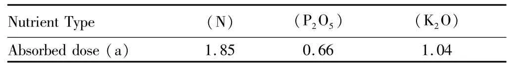
Table 1 The average nutrient absorption of 100 kg maize(kg)
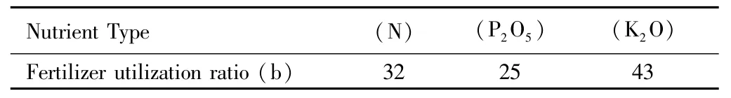
Table 2 The fertilizer utilization ratio(%)
3.2 Application of multiscale regional formula fertilization
3.2.1 Fertilizer formula at county-level.When the area of county level is 10000-100000 ha,and regional target yield is cultivated land productivity in eco-climate scale,fertilizer formulas for 108 counties in Shanxi Province can be calculated with the multiscale regional optimized formula fertilization system.Some are listed in Table 3.According to formula examination of Shanxi in 2014,fertilizer formula for maize in Hejin City 22-9-9 NP2O5-K2O,641kg/667m2recommends fertilizer rate 65 kg-75 kg:25 kg-41 kg N,14 kg-15 kg P2O5,14 kg-16 kg K2O.And fertilizer formula for maize in Xinjiang County 22-9-9(N-P2O5-K2O),641 kg/667m2suggests fertilizer rate65 kg-75 kg:25 kg-41 kg N,14 kg-15 kg P2O5,14 kg-16 kg K2O while fertilizer formula for maize in Wenxi County 22-9-9(N-P2O5-K2O),641 kg/667m2advises fertilizer rate 65 kg-75 kg:25 kg-41 kg N,14 kg-15 kg P2O5,14 kg-16 kg K2O.
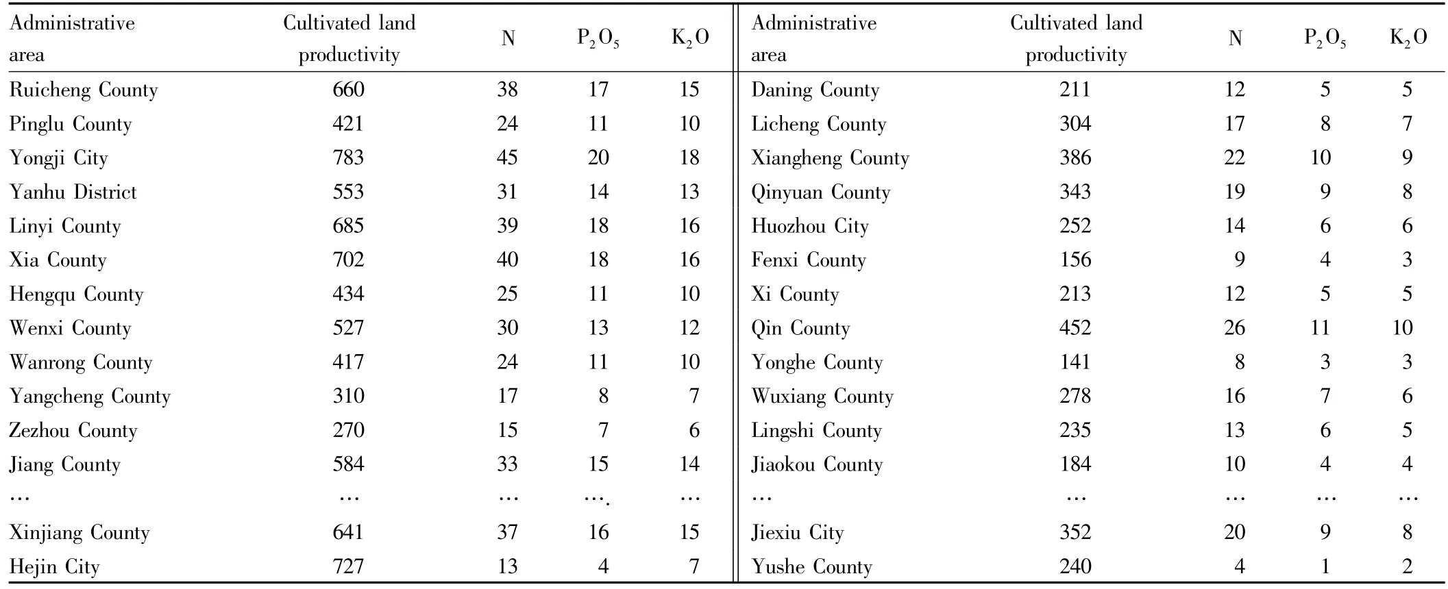
Table 3 108 regional productivity and fertilizer formulas in Shanxi at county level(kg/667 m2)
3.2.2 Multiscale regional formula.Fertilizer formula with integrating systems is user-oriented,but for various reasons,users have no complete control of regional environment information.Also,there is limited environment information in the system database so that it is hard to be adopted in reality directly.Considering the incompleteness of cultivated land information,the system deduces fertilizer rate according to interval length and mid-value of regional fertilizer rate.The interval length is defined as absolute value between high limit value and low limit value while interval mid-value is the average value of high limit value and low limit value.Xinjiang County,located in the southern Shanxi Province,41km from north to south and 25km from east to west,is typical maize-wheat cropping area.If there is no environment information(Qij=0),when regions in Xinjiang County are chosen,interval mid-value of regional fertilizer rate in different range is in accordance with the value in formula at county-level.Information about interval length is shown in Table 4.If scaleTs(Ts=0)is not taken into consideration,and interval length difference influenced by rate of fertilizer application can be calculated according to current environment information,and interval mid-value is the same as the value in fertilization formula at county level(Table 5).In practice,any region in system,environment information and scales should be considered to count variation of fertilizer interval length and mid-value.Analyzers are capable of choosing cultivated land area 0.9 ha in the base map of Xinjiang County with mouse,and putting it into different scale,narrowing the region based on complete environment information gradually to analyze fertilizer condition.The details can be found in Table6.Still another point needs to be taken up here:users' understanding of environment information is poor due to insufficient knowledge.When the system is designed,to do addition accordingly with fertilization region determined by complete environment information which includes known environment information will be adopted,to extend the interval.When the value of soil nutrient is definite and water conservation indefinite,the minimum interval length of region fertilization is9-4-3.To add the interval length of soil nutrient to interval length of water conservation,then the interval length of fertilizer is13-6-5,but mid-value of fertilizer keeps unchanged(36-16-15).
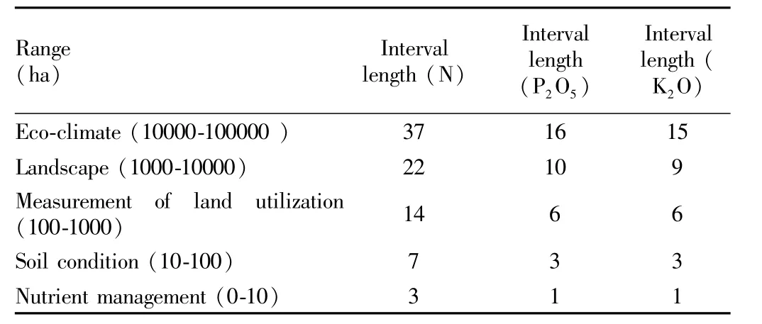
Table 4 The interval length of region varying with range considering no environment information(kg/667 m2)
3.2.3 Fertilizer formula for block.Regarding fertilizer in block,content of nutrient in soil should be analyzed according to soil sample testing data to establish regression model of testing value and fertilizer rate to carry out decision fertilization.The system can also store relevant statistic data which can be called at any time when calculating block formula fertilization.
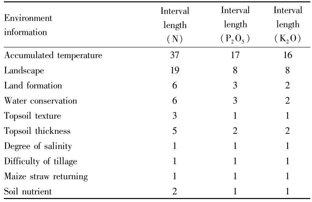
Table 5 The interval length of region varying with environment information ignoring scale(kg/667 m2)
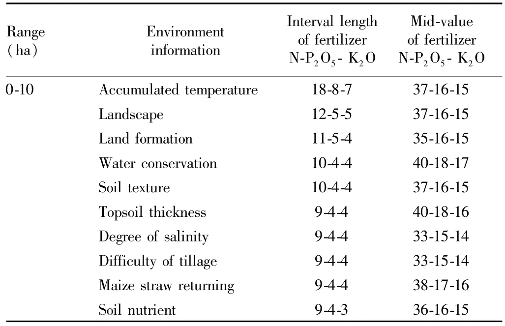
Table 6 The length and middle value of region varying with range of selected region(kg/667m2)
4 Conclusions
This paper mainly analyzes the shortage of traditional formula fertilization which can't gain regional fertilizer rate considering incomplete environment information,puts forward multiscale regional formula fertilization based on traditional method,and designs system accordingly.During the process of regional formula fertilization,different formula fertilization varying with regions should be adopted and formula should be reasonable.And in small region like block,formula fertilization can be in accordance with traditional formula fertilization.With the application of multiscale method,fertilizer formulas for 108 counties in Shanxi Province with target yield method can be obtained.Once these formulas are confirmed,decision can be made according to the completeness of environment information,and fertilizer region can be shrunk in total.The system is also available for multiscale formula fertilization transition from region to block,and this completeness of regions makes formula fertilization have realistic meaning.Application cases in Xinjiang County suggest that optimized method is functional for formula fertilizer with incomplete environment information.There are still some improvements in need for current model,for example,target yield for multiple scale regional cultivated land productivity is assured under static condition,but in practice factors that have impact on growing of the plants are diverse.So the establishment of dynamic model by long-term observation is necessary in the future.
[1]GUAN XK,ZHANG FR,GUO LN,et al.A suitability evaluation of cultivated land in Beijing for multi-purposes use and its spatio-temporal investigation[J].Resource Science,2010,32(3):580.(in Chinese).
[2]YU FQ,CAI YL.A new insight of cultivated land resource value[J].China land Science,2003,17(3):3.(in Chinese).
[3]YAN Y,LIU JL,ZHANG JB.Evaluation method and model analysis for productivity of cultivated land[J].Translation of the Chinese Society of Agricultural Engineering,2014,30(5):204.(in Chinese).
[4]MA TG,CHANG QR,ZHAO YT,et al.Evaluating productivity of farmland in Wugong County,Shaanxi Province[J].Bulletin of Soil and Water Conservation,2011,31(2):186.(in Chinese).
[5]MEHLICH A,Mehlich No.3 soil test extractant:A modification of Mehlich No.2 extractant[J].Communications in Soil Science and Plant Analysis,1984(15):1409.
[6]PIER JW,DOERGE TA.Concurrent evaluation of agronomic,economic,and environmental aspects of trickle-irrigated watermelon production[J].Journal of Environmental Quality,1995(24):79-86.
[7]SEXTON BT,MONCRIEF JF,ROSEN CJ,et al.Optimizing nitrogen and irrigation inputs for maize based on nitrate leaching and yield on a coarsetextured soil[J].Journal of Environmental Quality,1996(25):982.
[8]MAHENDRA SINGH,YADAVSS,VINOD KUMAR.Leaching and transformation of urea in dry and wet soils as irrigation water[J].Plant and Soil,1984(81):411.
[9]LIU WT,LIU SY,HAO JF.Discussion on several parameters of the calculation formula for the diagnosis and fertilization in Changchun city[J].Chinese Journal of Soil Science,1984,15(3):117.(in Chinese).
[10]ZHANG K,ZHAO JY,WANG XF,et al.Preliminary study on the economic and rational use of phosphorus fertilizer and phosphorus fertilizer in black soil[J].Chinese Journal of Soil Science,1984,15(3):120.(in Chinese).
[11]JIANG WB,YANG TC,SHAN WB.Research and application of the technology of diagnosis and fertilization in Maize[J].Journal of Jilin Agricultural University,1986:8(4):62.(in Chinese).
[12]ZHANG DG,LIU WR,BIAN XZ.Study on several main parameters and their application in soil testing and fertilization in maize[J].Journal of Jilin Agricultural Sciences,1987(1):58.(in Chinese).
[13]ZHOU MZ,WANG ZM.Study on new equations and its parameters for calculation of the requirement of nitrogen according to the maximum yield of rice predicted[J].Acta Pedological Sinica,1987;24(2):127.(in Chinese).
[14]LI WB,LI YD,WANG H.Application and recovery of15 N-fertilizer for spring maize in black soil of Jilin[J].Acta Pedological Sinica,2001,38(4):476.(in Chinese).
[15]ZHENG XD,PENG JW,LUO ZC,et al.Effect of formula fertilizer with applying mode of gross formula and minor adjustment on growth and yield of early rice[J].Hunan Agricultural Sciences,2012(21):54.
[16]MENG H,LI XD,HAN M,et al.Establishment of Songnen wetland information system based on GIS[J].Computer Engineering,2005,31(7):49.(in Chinese).
[17]BIRT,WANG B,DUAN YH,et al.Establishment and application of land resource management information system--A case study of Yongji City[J].Acta Pedological Sinica,2004,41(6):962.(in Chinese).
[18]PAN D,CHENG JZ,LIQ,et al.The vegetable fertilizing expert system[J].Acta Agriculturae Boreall—Sinica,2000,15(3):118.(in Chinese).
[19]ZHAO ZY,PENG ZL,GAOX,et al.The development of decision-making system for fertilization based on soil analysis in Karst area[J].Guizhou Agricultural Sciences,2009,37(6):229.(in Chinese).
[20]WANG PJ,MA YH,FANG CH,et al.Development and application of decision-making system for soil testing and fertilizer recommendations at county level in Anhui Province[J].Chinese Agricultural Science Bulletin,2009,25(4):283.(in Chinese).
[21]LU MX,HE LY,WU LS.Fertility evaluation of cultivated land in China:A review[J].Ecology and Environmental Sciences,2006,15(4):866.(in Chinese).
[22]ZHANG QQ,BI RT,ZHANG WP,et al.Building multi-scale EGLSN system and simulating cultivated land productivity[J].Chinese Journal of Eco-Agriculture,2015,23(3):345.(in Chinese).
[23]ZHANG FS.Soil testing and fertilization recommendation[J].Beijing:China Agricultural University Press,2011:66-68.(in Chinese).
杂志排行
Asian Agricultural Research的其它文章
- Study on Circulation and Management of Rural Land Use Right
- Construction of Rural Grass-roots Water Conservancy Service System in the Context of Institutional Changes
- Preliminary Study on Management of Agricultural Scientific Research Projects in the New Situation
- On Income Distribution Mechanism of Farmer Cooperatives in the Context of Membership Heterogeneity
- Review and Prospect of Development Capability of New Generation Farmers
- Empirical Study on Grow th of Evil Forces in Land Requisition and Relocation in City G of Hubei Province Based on Social Network Analysis