Distributional characteristics and sources of elements in soil from typical area of Pearl River Delta economic zone,Guangdong Province,China
2015-01-17LeiDouShuZhenShenHaiYanDu
Lei Dou•Shu-Zhen Shen•Hai-Yan Du
Distributional characteristics and sources of elements in soil from typical area of Pearl River Delta economic zone,Guangdong Province,China
Lei Dou1•Shu-Zhen Shen2•Hai-Yan Du1
Dongguan City,located in the Pearl River Delta economic zone of China,is famous for its rapid developing township-enterprises in the past 30 years.A total of 759 composite soil samples,including 606 surface soil samples and 153 deep soil samples,have been collected in the city.These samples have been analyzed for 13 elements(Al,As,Cu,Cd,Co,Cr,Fe,Hg,Mn,Ni,Pb,Si, and Zn)and other parameters(pH values and organic matter)to evaluate the infuence of anthropic activities on the soil environmental quality and to identify the spatial distribution of heavy metals and their possible sources.The results indicate that the average concentrations of heavy metals in soil were signifcantly lower than the threshold of the second grade of the Soil Environment Quality Standard in China(GB15618-1995)and the soil environmental quality in this area is comparatively good.But in comparison with local soil geochemical baseline values,As, Cd,Cu,Hg,Pb,and Zn have accumulated remarkably. Specifcally,the average concentrations of As,Cd,Cu,and Hg in the small part samples of the west plain and central areas are higher than the national second-grade quality standard,indicating some level of contamination.Multivariate and geostatistical methods have been applied to differentiate the infuences of natural processes and human activities on the concentration of heavy metals in surface soils in the study area.Cluster and factor analyses result in the grouping of Al,As,Cr,Cu,Fe,Ni,and Si into factorF1;Co,Mn,Pb,and Zn into F2;and Cd and Hg into F3. The spatial pattern of the three factors may be well demonstrated by geostatistical analysis.It is shown that the frst factor could be considered as a natural source controlled by parent material.The second factor could be referred to as‘‘industrial and traffc pollution sources’’.The source of the third factor is mainly controlled by long-term anthropic activities,including agricultural activities,fossil fuel consumption,and atmospheric deposition.
Heavy metals·Distributional characteristics· Source·Multivariate statistics·Geostatistics·Typical intensive area of township-enterprises·Pearl River Delta economic zone
1 Introduction
In the last three decades,the sustained and rapid socioeconomic development of the Pearl River Delta(PRD) region was gained at the cost of resources and environment. Soil polluted by heavy metals is one of the main environmental problems in the PRD economic zone(Gao and Guo 2003;Xie 2003;Zhou et al.2004;Zhu et al.2005).It directly threatens the stability of regional ecosystem and food safety,and has profound infuences on economic sustainability,especially for sustainable agriculture and human health(Chen et al.1997;Zhu et al.2005).The natural concentration of heavy metals in soil depends primarily on the geological parent material compositions(De Temmerman et al.2003).However,normal agricultural practices generally cause an enrichment of some elements (Mantovi et al.2003).Mining and other human activities, including the combustion of fossil fuels and waste incineration,have signifcantly increased the emission of heavymetals into the atmosphere.The natural input of several trace elements into soils due to pedogenesis has been exceeded by human input(Facchinelli et al.2001).Whether from natural or anthropogenic sources,heavy metals might have a negative effect on the quality of agricultural products and result in the transfer of trace metals to the human diet(Baranowska et al.2005;Zheng et al.2007).
In order to provide a scientifc basis for socio-economic development and planning to improve the ecological environment in this region,the People’s Government of Guangdong Province and the China Geological Survey (CGS)signed an agreement of‘‘Agro-geological survey and eco-geochemical assessment in Pearl River Delta Economic Zone of Guangdong Province’’in January 2006. Dongguan City,a typical intensive area of township-enterprises in the PRD economic zone,was taken as the study area in this paper.The main sources of heavy metals in the soil were analyzed through a combination of multivariate statistics and geostatistics.
Dongguan city(22°39′N–23°09′N,113°31′E–114°15′E) is famous for its rapid industrialization in the past 30 years. It is the most intensive area of township-enterprises in the PRD economic zone.It is situated within the northeastern PRD and in the south of Guangdong Province,China,and only has a total area of 2465 km2(5.9%of PRD),with a population over eight million(32%of PRD).This city connects with Guangzhou City in the north,and Shenzhen City and Hong Kong in the south.The dominant agricultural products include rice,vegetables,banana,litchi, longan,pineapple,and aquatic products.
Since the reform and open policy in China,industry has increased dramatically at 22%annually.Gradually,export-oriented industries have expanded,including household electrical appliances,communication equipment, textile and clothing,electrons,building materials,medicine,hardware,and the plastic chemical industry.Dongguan has become an importantindustry base of international manufacturing.According to statistics,the number of industrial enterprises in Dongguan reached 16,000 in 2005.In Humen(a town in Dongguan)alone, there are more than 100 enterprises,including an electroplating factory,a paper mill,a rinsing facility,and other heavy-polluting enterprises.Since the inception of the industrial growth, agro-environmental problems have emerged and agricultural production has been strongly affected.Large amounts of pollutants,including heavy metals,have been transported continuously into agricultural soils either directly or indirectly.With the dual infuence of natural and anthropic input,the sources of trace elements become more complex.
The objectives of this study are(i)to investigate the concentrations of heavy metals,including As,Cd,Cr,Cu, Hg,Ni,Pb,and Zn in the soil of a typical townshipenterprise intensively developed area in the PRD economic zone,(ii)to characterize spatial distribution of heavy metals in soil,and(iii)to identify their possible sources in surface soils by a combination of multivariate statistics and geostatistics.
2 Materials and methods
2.1 Characteristics of the study area
The southeast of Dongguan is in low mountains and hilly regions.The northwest tilts over the low hill,platform,and valley plain.The west and south of the study area are lowlying river delta river network areas and marine plain areas. River networks are dense in this area,and it is infuenced by the river food tide because it is situated in an estuary zone.Dongguan belongs to the subtropical monsoon climate—mild and wet with plentiful rainfall.The mean annual temperature is 21.82°C.
Dongguan City has seven soil types in total,in which the latosolic red soil and paddy soil are the most common types and account for 51.43%and 45.20%,respectively,of the total land area.The latosolic red soil is mainly distributed in the hilly and tableland areas,with the parent material mainly of granite and sandy shale.The paddy soils are mainly distributed in the plain area,with the parent materials being mainly diluvial deposits,river alluvium,delta alluvial deposits,and littoral sediments.The rocky soil and seashore saline soil account for 2.56%,while other soil types account for less than 1%.The soil textures are mainly clay loam and loam,and secondarily clay and sand.
According to land use surveys in 2008,farm land covers 1780.4 km2,which accounts for 72.23%of total land in the study area.Cultivated land,garden plots,and forest land account for 30.96%,35.87%,and 32.17%respectively;construction accounts for 20.18%of total land area; and unused land accounts for 7.59%.
Dongguan can be divided into four areas based on geomorphological characteristics.The north environmental protection area(I)is so-called due to the strict control of various polluting industries in order to protect the water source since 1991.The area is located in the eastern part of the upriver east river,and covers 213.0 km2.It acts as the main water source for the east river,Shenzhen,as well as for the Dongguan canals.The west plain area(II)has abundant water and high density of town-owned enterprises,and consists of 11 towns with an area of 549.7 km2. Area soils are predominantly derived from deposits from the east river,and many resource-consuming enterprises were developed at the early stage of China’s reform and open policy due to convenient traffc and abundant rivers passing by.The central area(III)consists of eight townswith an area of 693.5 km2.Parent materials of area(III) soils are modern sediments from the east river,granite,and red sandstone.The southeast hilly area(IV)consists of nine towns with an area of 1018.6 km2,where the water source is short and the parent materials are mainly granite and sandstone.
2.2 Soil sampling and chemical analysis
Surface and deep soils were separately collected in the study area according to two-layer grid sampling(CGS 2011).Surface soils were collected at a sampling density of one sample/km2.All samples were from 0 to 20 cm in depth.Four surface soil samples from adjacent grids were combined into one sample for chemical analysis.Samples from the deep soil at 150–200 cm depth were collected at a sampling density of one sample/4 km2.Four deep soil samples from adjacent grids of land area were combined into one sample for chemical analysis.A total of 2424 surface soil samples and 612 deep soil samples have been collected,with 606 composite surface soil samples and 153 composite deep soil samples prepared for analysis(Fig.1).
Soil samples were prepared according to the standard procedure in the guidebook for multi-purpose regional geochemical survey(DD2005-01).The soil samples were air dried at room temperature.Impurities,such as stones and tree leaves,were removed.Coarse soil particles (>0.84 mm)were crumbled by wooden hammer,and the samples were sieved by a nylon screen to<0.84 mm after being dried;100 g samples<0.84 mm were further processed with an agate mortar to<0.074 mm for analysis. The test was conducted by the analytical center of the Institute ofGeophysicaland GeochemicalExploration (IGGE).
Table 1 presents the analytical methods and corresponding detection limits.Standard reference materials (SMR)and duplicate samples were used to control analytical quality.Four SMRs of the GSS series(including GSS1,GSS2,GSS3,GSS8,GSS10,and GSS13),produced by IGGE in China,were inserted blindly into each of the 50 soil samples and were analyzed simultaneously with the samples.The logarithmic difference(ΔlgCSRM)between the analytical value and the standard value of each determination was then calculated to monitor the accuracy of the sample analyses.Analyses were considered acceptable if the ΔlgCSRMwas<0.12 for samples with concentration within three times the detection limit and<0.10 for samples with concentrations over three times the detection limit.Duplicate samples,equaling 5%of the total number of samples,were inserted randomly to evaluate the precision of the analyses.The percentage of relative deviation (RD)was calculated.Analyses were considered acceptable if the RD was-40%≤RD≤40%.The logarithmic difference of As,Cd,Co,Cr,Cu,Hg,Mn,Ni,Pb,Zn, Al2O3,Fe2O3,SiO2,and Corgin the GSS series ranged from 0.000 to 0.086.The qualifcation rate of accuracy obtained from logarithmic difference is 100%.The precision of As, Cd,Co,Cr,Cu,Hg,Mn,Ni,Pb,Zn,Al2O3,Fe2O3,SiO2, and Corgobtained from replicate analysis varied from -33.94%to 36.81%(Table 2).The results indicate that the test quality accorded with the standard of multi-purpose regional geochemical survey and the analytical data are reliable(CGS 2006).
2.3 Statistical methods
Factor analysis(FA)is applied in this study.FA is a useful statistical tool that can extract latent information from multidimensional data and group the measured elements into fewer groups(Gallego et al.2002;Liu et al.2003). Geostatistical analysis is also applied in this study:the technique of a variogram(or semi-variogram)is used to measure the spatial variability of a regionalized variable, and provides the input parameters for the spatial interpolation of kriging(Webster and Oliver 2001;Cai et al. 2008).Ordinary kriging is chosen to create spatial distribution maps of the results of FA.
3 Results
The element concentrations and soil properties of surface soils in Dongguan City are listed in Table 3.The mean value of soil pH was 5.81(3.91–8.25).The element concentrations range over several orders of magnitude with larger variations.The coeffcients of variation(CV)of all heavy metals except Pb(43.93%)were more than 50%, and the CV of Hg was the largest(118.18%).On a large scale,the mean concentrations of heavy metals were signifcantly lower than the threshold of the second grade of the Soil Environment Quality Standard in China(GB15618 1995).
The mean concentrations of Cd,Cu,Hg,Zn,and SiO2in surface soils were signifcantly higher than in deep soils (Tables 3,4).The mean concentrations of Mn and Pb in surface soils were similar to those in the deep soil.The mean concentrations of As,Co,Cr,Ni,Al2O3,and Fe2O3were signifcantly lower in surface soils than in deep soils. In this study,the statistics of each element concentration in deep soil were regarded as the soil geochemical baseline value(CGS 2006,2011).If the element concentration in deep soil obeyed normal distribution or logarithmic normal distribution,the arithmetic mean value or geometric mean value was regarded as the geochemical baseline value. When the element concentration in deep soil did not obey normal or logarithmic normal distribution,the abnormityhigher than mean add three times standard deviation(SD) or lower than mean add three times SD were eliminated repeatedly.If the data that had been eliminated obeyed normal distribution or logarithmic normal distribution,the arithmetic mean value or geometric mean value of the data was regarded as the geochemical baseline value.Otherwise,the mode was regarded as the geochemical baseline value.The geochemical baseline value of each element is listed in Table 3.The mean concentrations of Cr and Ni in surface soil were lower than or close to the soil geochemical baseline values of Dongguan City(Table 3),and the mean concentrations of others in surface soil were higher than the corresponding geochemical baseline value. Results show that Cr and Ni were affected by natural effects;strong leaching action leaves deeper soils enriched in these elements.Other elements affected by human activities are signifcantly enriched in surface soil.Furthermore,the concentrations of As,Cd,Cu,and Hg of a few samples were signifcantly higher than the second grade, with maximums up to 120.3,128.2,2.14,and 0.89 mg/kg, respectively.

Fig.1 Location of study area and sample sites
4 Discussion
4.1 Distributional characteristics and sources of elements in surface soils
Ranges,means,and SD of elements for each district were calculated and are listed in Table 5.The average concentration of Pb in the west plain and central areas was higher than the local geochemical baseline value and followed the order:west plain>central>southeast hill>north environmental protection area.The average concentration of Cd in the west plain area was the highest among all the districts.The highest average concentrations of As,Cd,Cr, Cu,Hg,Ni,Pb,and Zn were all in the west plain area, while the lowest ones were in the north environmentalprotection area and southeast hilly area.In general,each element in the soil existed at a concentration based on its natural conditions.The results show that the sample sites with elements over the soil geochemical baseline values were concentrated in the west and central areas(Cd,Cu, Hg,Ni,Pb,Zn),and appeared least in the north environmental protection area.The results indicate that soil environmental quality in the area is comparatively good,but some sites in the west plain and central area might be slightly contaminated.
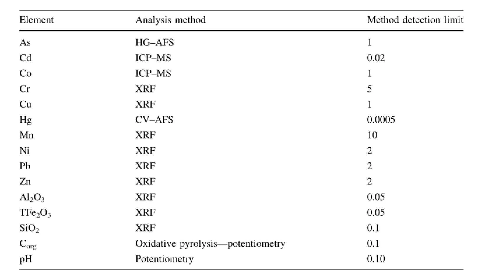
Table 1 Analysis method and detection limits for samples
4.2 Source of elements in surface soils
Generally,heavy metal pollution is complicated.Interelement relationships can provide useful information on trace element sources and pathways(Manta et al.2002).To obtain valuable information,the partial correlation coeffcients are calculated between 13 elements and their related soil properties(pH,organic matter).The correlation analyses show that As,Cr,and Ni are signifcantly as well as positively correlated at the 0.01 signifcance level,which may suggest a common origin.Cd has a signifcant correlation with Hg,Ni,Zn,and organic matter,but little signifcant correlation with Cu.
The results of FA for trace element concentrations are presented in Table 6.Three factors are extracted from the available data set,and account for over 75%of all the data variation.Al,As,Cr,Cu,Fe,Ni,and Si are strongly associated with the frst factor(F1).The second factor(F2) includes Co,Mn,Pb,and Zn.The third factor(F3)mostly condenses the information of Cd,Cu,Hg,and Zn;it is worth noting that Cu and Zn are also partially represented in F1 and F2,respectively.
F1 can be considered to be a lithogenic component,as the variability of the elements seems to be controlled by the parent material.The parent material factor explains 33.06%of the total variance and it is the most important component.This result suggests that the distributions of As,Cr,Cu,and Ni have a lithogenic control.On the other hand,relatively lower loading factors of As,Cr,Cu,and Ni in the anthropogenic components(F2 and F3),suggest other effects(e.g.,agricultural practices or industrial contamination)on the status of these elements in the soil.
F2 includes Co,Pb,and Zn and can be considered to be an anthropogenic component.According to earlier discussion,the mean concentration of Pb has exceeded the local geochemical baseline value and is moderately enriched in the topsoil.This indicates an anthropic input.Common sources of Pb in soils are manure,sewage sludge,leadarsenate pesticides,vehicle exhaust,and industrial fumes. Coal burning is also acknowledged to be a source of lead pollution.Although Pb derived from car exhausts does not extend appreciably beyond 30 m from the road(Facchinelli et al.2001),lead aerosols,industrial fumes,and coal burning exhausts can be carried over longer distances (Kober et al.1999;Facchinelli et al.2001).
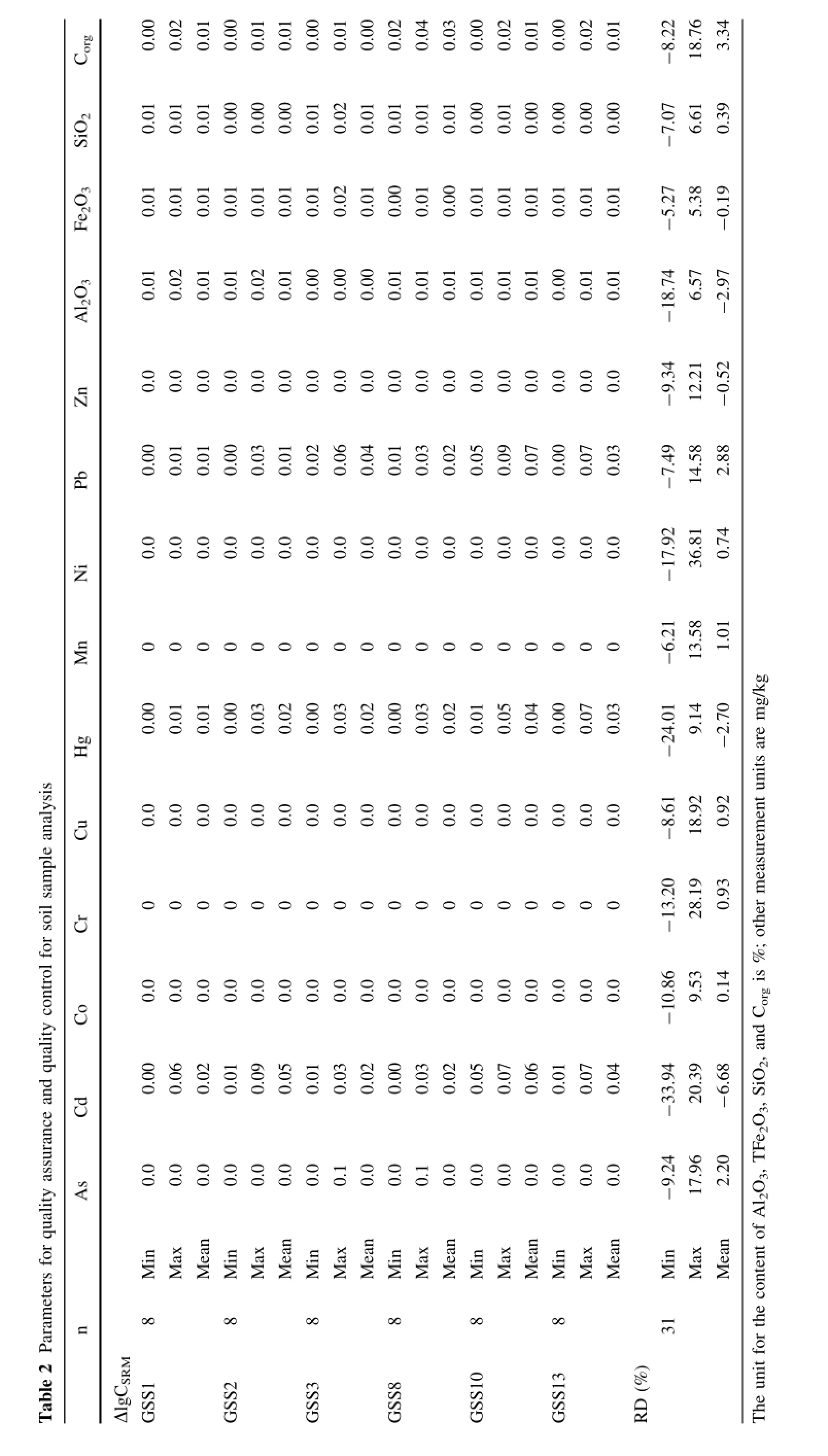

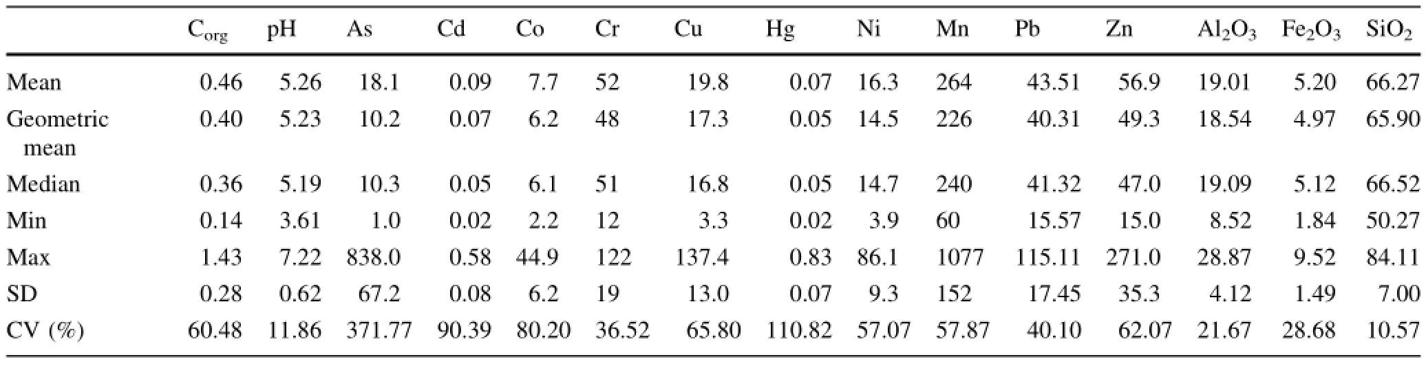
Table 4 Summary statistics for element concentrations(mg/kg)in deep soil(n=153)
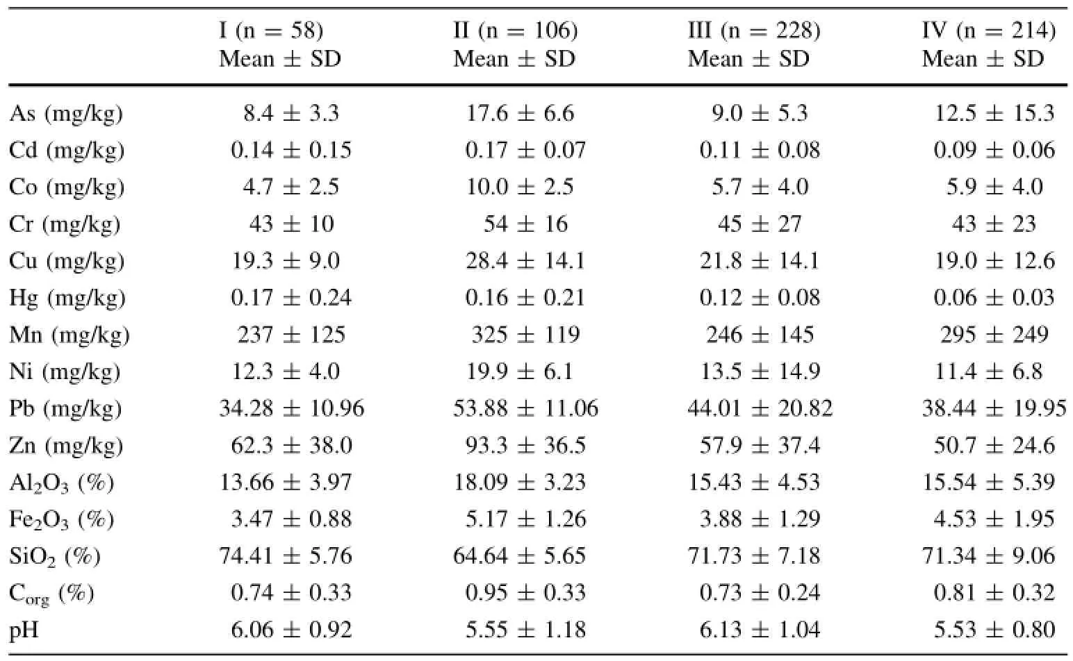
Table 5 Average concentrations of elements in surface soil in different areas
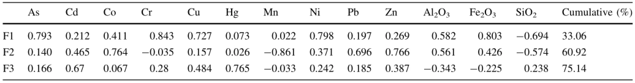
Table 6 Component matrix for 13 element concentrations in surface soil(n=606)
F3 includes Hg and Cd concentrations,which can be a distinguishing anthropogenic component.It is well known that a lot of chemical fertilizers,manures,and sludge are used in the vegetable felds to increase vegetable outputs (Liu et al.2004).Phosphate fertilizers are an important source of heavy metals,especially Cd,Cu,and Zn,which enter agricultural soils.Other sources of Cd may include other inorganic fertilizers(e.g.,nitrogen or potash),atmospheric deposition or anthropic wastes such as sewage sludge,wastewater,or waste materials.Meanwhile,because the area is an important international manufacturing industry base in China,and connects with Guangzhou and Shenzhen,which are two economically developed cities in China,the industrial fumes and atmospheric deposition may also be important sources of Hg enrichment in soil (Linak and Wendt 1994;Ikingura et al.2006;Wang et al. 2003;Mukherjee and Zevenhoven 2006;Mukherjee et al. 2008).Zheng et al.(2011)estimated the total mercury emissions to be 17,244 kg in the PRD region for the year of 2008,and anthropogenic activities were dominant sources. Dongguan is one of the largest regions for mercury emission(Zheng et al.2011).Therefore,F3 can also be an anthropogenic component due to the isolation of Cd and Hg from lithogenic elements.
Cluster analysis is often coupled with FA to confrm results and provide grouping of variables(Facchinelli et al. 2001).In order to identify distinct sources of heavy metals, cluster analysis was performed on 13 elements.The 13 elements in soils can be classifed into three types based on the correlation coeffcients by using the furthest neighbor linkage method.Group I is comprised of Al,As,Cr,Fe,Mn,Ni, andSi;Group2iscomprised ofCo,Pb,andZn;andGroup3 includesCdandHg.Theelementsineachgrouphavesimilar sources or releasing principles in soils.The results are in good agreement with FA results.
Cu has approximative loading factors in the frst and third principal factors,indicating a mixed source from natural and anthropic origins.Cd and Zn have approximative loading factors in the second and third principal factors,indicating a mixed source from two different kinds of anthropogenic inputs.The sources may be associated with Cd-based or Zn-based agrochemicals related to specifc agronomic practices.
According to the above discussion,it seems reasonable to conclude that Cd,Hg,Pb,and Zn constitute an anthropogenic component related to specifc human activities, whereas the other elements(As,Cr,and Ni)are obviously associated with parent material.In the case of Cu,it displays a combined relationship with both groups and seems to have both natural and anthropic origins.
The attributes of the semivariograms for each factor are summarized in Table 7.Semivariograms show that the frst and the second factors are well ftted with the spherical model(r2=0.852,0.993,respectively),whereas the third factor is better ftted to the exponential model(r2=0.973). The theoretical model is plotted for each factor obtained.
The nugget/still ratios can be regarded as the criterion to classify the spatialdependence of soil properties (Facchinelli et al.2001).The nugget/sill ratio for all the three factors is below 50%(Table 4),which suggests that the spatial heterogeneity of these factors is mainly caused by their spatial correlation.Among these factors,the frst factor(C0/(C+C0)=0.35)and the second factor (C0/(C+C0)=0.36)show a stronger spatial correlation than the third factor(C0/(C+C0)=0.46).
In order to know the distribution patterns of the three factors,kriging interpolation is used to obtain the spatial distribution of the scores on principal components(Figs.2, 3,4).The higher scores of the frst factor are in the west of the study area(Fig.2).Compared to the parent materials of the soil,the distribution of the higher scores of F1 shows similar trends to the distribution of alluvial and marine deposits(Fig.5).The distribution of the lower scores is controlled by the soil derived from acidic eruptive rocks and granite.All of these observations suggest that natural factors play an important role in controlling the distributionof F1.The result coincides with the analysis of the structure mentioned earlier in this article.

Table 7 Best-ftted semivariogram models of surface soil elements and their parameters(n=606)

Fig.2 Spatial distributions of factor 1
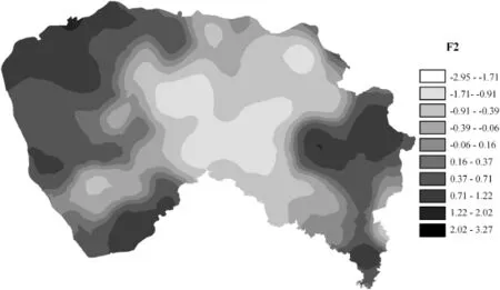
Fig.3 Spatial distributions of factor 2

Fig.4 Spatial distributions of factor 3
The higher scores of F2 are distributed in the west plain and central areas,especially in Zhongtang,Humeng,and Chashan(three towns in Dongguan)(Fig.3).Because of the prominent regional advantages,convenient traffc,and abundant water resources,some resource-consuming enterprises have developed rapidly in the west plain area,at the initial stage of the reform period and during the past 30 years.With the increasing development of heavily polluting industries,a great number of heavy metal pollutants have been discharged into the environment,and the area has become the most severely polluted part of Dongguan City.
The spatial distribution of F3 distinctly differs from the other two factors,showing a trend of nonpoint source pollution(Fig.4).It is reported that Cd and Hg pollution in urban soil is widespread in China,and usually originates from the application of agrochemicals,sewage irrigation, fossil fuel consumption(especially coal burning),and atmospheric deposition(Nakagawa and Hiromoto 1997; Wang et al.2003;Kuo et al.2006).Cd is usually considered as a marking element of agricultural activities,which includes the use of pesticides,chemical fertilizers,and so on(Nicholson et al.2003;Rodriguez et al.2006).According to statistics(Bureau of Statistics of Dongguan 2005),there have been two million tons of chemical fertilizers and 35 thousand tons of pesticides used in Dongguan City since 1990.The application rate of pesticides and chemical fertilizers is generally much lower in China. Approximately 70%of pesticides and fertilizers drain intothe soil,water,and air.Long-term agricultural production activities result in an obvious accumulation of heavy metals such as As,Cd,and Cu in the soils.In addition,coal has been used for many years in China.Many cities have been reported to have Hg pollution problems,especially in South China(Nakagawa and Hiromoto 1997;Wang et al. 2003).Therefore,the source of F3 must mainly be controlled by long-term anthropic activities as a consequence of agricultural activities,fossil fuel consumption,and atmospheric deposition.
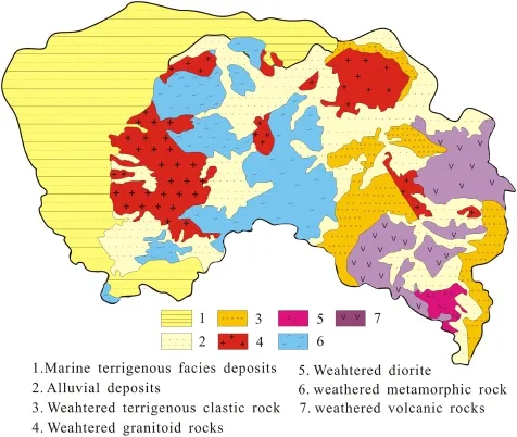
Fig.5 Soil parent materials in study area
The concentrations of heavy metals in soils from different parent materials vary greatly.The mean concentrations of As,Cr,and Ni in soils derived from marine terrigenous facies deposits are 2.79,2.77,and 2.87 times of those derived from sandstone and shale,respectively.The concentrations of As,Cr,Cu,Hg,Ni,and Zn in surface soils derived from marine terrigenous facies deposits are the highest in all parent materials.The concentrations of Pb in surface soils derived from marine terrigenous facies deposits and granite are higher than concentrations derived from the other parent materials.Moreover,the average concentration of Cd in surface soils derived from granite is the lowest.
5 Conclusions
The results obtained in this study increase one’s knowledge of heavy metal concentrations and their possible sources in the soils.The results obtained in this study indicate soil environmental quality in the area of Dongguan City,China, is comparatively good.On a large scale,the average concentrations of heavy metals were signifcantly lower than the threshold of the second grade of Soil Environment Quality Standard in China(GB15618 1995),but higher than local soil geochemical baseline values for elements analyzed(the exceptions being Cr and Ni).Isolated areas of the west plain and central areas are slightly contaminated, probably due to different amounts and types of key pollution sources in each area.The concentrations of As,Cd,Cu, and Hg in the samples are higher than the national second grade quality standard,with maximum values up to 120.3, 0.89,128.2,and 2.14 mg/kg respectively.
A combination of multivariate statistical and geostatistical methods was performed on 13 heavy metals,identifying three principalcomponents to representthe variability of heavy metals in agricultural soils.
As,Cr,Ni,and partial Cu concentrations,dominating the frst principal component,represent natural soil parent materials.The higher values of F1 distributed in the west plain area are affected by marine sediment and fuvial deposition;the lower values in the central and southeast hilly areas are mainly controlled by the distribution of weathering materials derived from granites and acidic volcanic rocks.Variability of scores on the second and third principal components(F2 and F3)may mainly be due to the infuence of anthropic activities.The higher scores of F2(Pb)are distributed in the west plain and central areas, especially in Zhongtang,Humen,and Chashan,which aremainly affected by industry and traffc pollution.Finally, the spatial distribution of F3(Cd and Hg)shows a trend of nonpoint source pollution,mainly due to long-term anthropic activities,especially fossil fuel consumption,atmospheric deposition,and agricultural activities.
AcknowledgmentsThis work was supported by the China Geological Survey Project(1212010511216)and Environmental Protection Special Foundation of Guangdong Provincial(Guangdong Environment[2014]126).We also would like to thank the anonymous reviewers for their valuable comments and suggestions to improve the quality of the paper.
Baranowska I,Barchanska H,Pyrsz A(2005)Distribution of pesticides and heavy metals in trophic chain.Chemosphere 11:1590–1599
Bureau of Statistics of Dongguan(2005)Dongguan City statistical year book,2004.China Statistics Press,Beijing,p 190(in Chinese)
Cai L,Ma J,Zhou Y,Huang T,Dou L,Zhang C,Fu S(2008) Multivariate geostatistics and GIS-based approach to study the spatial distribution and sources of heavy metals in agricultural soil in the Pearl River Delta,China.Environ Sci 12:3496–3502 (in Chinese with English Abstract)
Chen T,Wong J,Zhou H,Wong M(1997)Assessment of trace metal distribution and contamination in surface soils of Hong Kong. Environ Pollut 1:61–68
China Geological Survey(CGS)(2006)Compilation of criterion for geological survey,fascicule of geochemical exploration.Unpublished book
China Geological Survey(CGS)(2011)Multi-purpose regional geochemical atlas of Pearl River Delta Economic Zone of Guangdong Province,People’s Republic of China
De Temmerman L,Vanongeval L,Boon W,Hoenig M,Geypens ME (2003)Heavy metal content of arable soils in Northern Belgium. Water Air Soil Pollut 1–4:61–76
明尼没有停下来报复,它只想逃开。它拖着鱼竿和渔线,迅速划入水下。鱼竿卡在了一处小凸起上,缠绕在明尼嘴上的渔线在引线器附近被扯断了。明尼潜入一块喝饱了水的厚木板底下,一面生着迟来的闷气,一面啃咬着鱼钩。终于,钩尖从下颚的下方滑了出去,卡在了木板中,引线器也从伤口滑落了,明尼自由了。
Facchinelli A,Sacchi E,Mallen L(2001)Multivariate statistical and GIS-based approach to identify heavy metal sources in soils. Environ Pollut 3:313–324
Gallego JLR,Ordonez A,Loredo J(2002)Investigation of trace element sources from an industrialized area(Aviles,northern Spain)using multivariate statistical methods.Environ Int 7:589–596
Gao L,Guo J,(2003)An analysis on the Pearl River Delta Region by Guangdong Provincial Department of Construction.Guangdong Construction Information 6,p 18(in Chinese)
GB15618-1995(1995)Soil environmental quality standards in China, Standards Press of China,Beijing(in Chinese)
Ikingura JR,Akagi H,Mujumba J,Messo C(2006)Environmental assessment of mercury dispersion,transformation and bioavailability in the Lake Victoria Goldfelds,Tanzania.J Environ Manag 2:167–173
Kober B,Wessels M,Bollhofer A,Mangini A(1999)Pb isotopes in sediments of Lake Constance,Central Europe constrain the heavy metal pathways and the pollution history of the catchment, the lake and the regional atmosphere.Geochim Cosmochim Acta 9:1293–1303
Kuo TH,Chang C,Urba A,Kvietkus K(2006)Atmospheric gaseous mercury in Northern Taiwan.Sci Total Environ 1:10–18
Linak WP,Wendt JO(1994)Trace metal transformation mechanisms during coal combustion.Fuel Process Technol 1–3:173–198
Liu X,Xu J,Zhang M,Zhou B(2004)Effects of land management change on spatial variability of organic matter and nutrients in paddy feld:a case study of Pinghu,China.Environ Manag 5:691–700
Manta DS,Angelone M,Bellanca A,Neri R,Sprovieri M(2002) Heavy metals in urban soils:a case study from the city of Palermo(Sicily),Italy.Sci Total Environ 1–3:229–243
Mantovi P,Bonazzi G,Maestri E,Marmiroli N(2003)Accumulation of copper and zinc from liquid manure in agricultural soils and crop plants.Plant Soil 2:249–257
Mukherjee AB,Zevenhoven R(2006)Mercury in coal ash and its fate in the Indian subcontinent:a synoptic review.Sci Total Environ 1:384–392
Mukherjee AB,Zevenhoven R,Bhattacharya P,Sajwan KS,Kikuchi R(2008)Mercury fow via coal and coal utilization by-products: a global perspective.Resour Conserv Recycl 4:571–591
Nakagawa R,Hiromoto M(1997)Geographical distribution and background levels of total mercury in air in Japan and neighbouring countries.Chemosphere 4:801–806
Nicholson FA,Smith SR,Alloway BJ,Carlton-Smith C,Chambers BJ(2003)An inventory of heavy metals inputs to agricultural soils in England and Wales.Sci Total Environ 311(1–3): 205–219
Rodriguez MJ,Arias ML,Grau CJ(2006)Heavy metals contents in agricultural topsoils in the Ebro basin(Spain).Application of the multivariate geoestatistical methods to study spatial variations. Environ Pollut 3:1001–1012
Wang D,Shi X,Wei S(2003)Accumulation and transformation of atmospheric mercury in soil.Sci Total Environ 1–3:209–214
Webster R,Oliver MA(2001)Geostatistics for environmental scientists.Wiley,Chichester,pp 37–103
Xie S(2003)A study on resources and environment and sustainable development strategy of the Pearl River Delta.Territ Nat Resour Study 4:41–43(in Chinese with English Abstract)
Zheng N,Wang Q,Zhang X,Zheng D,Zhang Z,Zhang S(2007) Population health risk due to dietary intake of heavy metals in the industrial area of Huludao city,China.Sci Total Environ 1–3:96–104
Zheng J,Ou J,Mo Z,Yin S(2011)Mercury emission inventory and its spatial characteristics in the Pearl Delta region,China.Sci Total Environ 412–413:214–222
Zhou G,Xie X,Liu Z,Chen M,Zhang Q,Fan H(2004)Potential ecological risk assessment of heavy metal in soils in the Zhujiang River delta:heavy metal activation in Soils.Geol Bull China 11:1088–1093(in Chinese with English Abstract)
Zhu Y,Chen B,Lin A,Ye Z,Huang M(2005)Heavy metal contamination in Pearl River Delta—status and research priorities.Acta Scientiae Circumstantiae 12:1575–1579(in Chinese with English Abstract)
Received:12 March 2014/Revised:21 May 2014/Accepted:5 June 2014/Published online:27 March 2015
©Science Press,Institute of Geochemistry,CAS and Springer-Verlag Berlin Heidelberg 2015
✉ Lei Dou
ggsdl@163.com
1Geological Survey of Guangdong Province, Guangzhou 510080,China
2Beijing Normal University Zhuhai Campus,Zhuhai 519087, China
杂志排行

Acta Geochimica的其它文章
- Sulfur determination by laser ablation high resolution magnetic sector ICP-MS applied to glasses,aphyric lavas, and micro-laminated sediments
- A large carbon pool in lake sediments over the arid/semiarid region,NW China
- Heavy metal(loid)pollution in mine wastes of a Carlin-type gold mine in southwestern Guizhou,China and its environmental impacts
- The controls on the composition of biodegraded oils in the Liuhua11-1 Oilfeld,Pearl River Mouth Basin,South China Sea
- Spatial pattern and distribution regularity of soil environmental quality in East China
- Characteristics of biomarker in source rocks of Linxi Formation in Taohaiyingzi region,Zhalute basin