Estimation of the Maximum Allowable Loading Amount of COD in Luoyuan Bay by a 3-D COD Transport and Transformation Model
2014-05-05WUJialinLIKeqiangSHIXiaoyongLIANGShengkangHANXiurongMAQiminandWANGXiulin
WU Jialin, LI Keqiang, SHI Xiaoyong, LIANG Shengkang HAN Xiurong, MA Qimin, and WANG Xiulin
1) Key Laboratory of Marine Chemistry Theory and Technology, Ministry of Education, Ocean University of China, Qingdao 266100, P. R. China
2) College of Chemistry and Chemical Engineering, Ocean University of China, Qingdao 266100, P. R. China
3) College of Environmental Science and Engineering, Ocean University of China, Qingdao 266100, P. R. China
Estimation of the Maximum Allowable Loading Amount of COD in Luoyuan Bay by a 3-D COD Transport and Transformation Model
WU Jialin1),2), LI Keqiang1),*, SHI Xiaoyong1),2), LIANG Shengkang1), HAN Xiurong1),2), MA Qimin3), and WANG Xiulin2)
1) Key Laboratory of Marine Chemistry Theory and Technology, Ministry of Education, Ocean University of China, Qingdao 266100, P. R. China
2) College of Chemistry and Chemical Engineering, Ocean University of China, Qingdao 266100, P. R. China
3) College of Environmental Science and Engineering, Ocean University of China, Qingdao 266100, P. R. China
The rapid economic and social developments in the Luoyuan and Lianjiang counties of Fujian Province, China, raise certain environment and ecosystem issues. The unusual phytoplankton bloom and eutrophication, for example, have increased in severity in Luoyuan Bay (LB). The constant increase of nutrient loads has largely caused the environmental degradation in LB. Several countermeasures have been implemented to solve these environmental problems. The most effective of these strategies is the reduction of pollutant loadings into the sea in accordance with total pollutant load control (TPLC) plans. A combined three-dimensional hydrodynamic transport-transformation model was constructed to estimate the marine environmental capacity of chemical oxygen demand (COD). The allowed maximum loadings for each discharge unit in LB were calculated with applicable simulation results. The simulation results indicated that the environmental capacity of COD is approximately 11×104t year-1when the water quality complies with the marine functional zoning standards for LB. A pollutant reduction scheme to diminish the present levels of mariculture- and domestic-based COD loadings is based on the estimated marine COD environmental capacity. The obtained values imply that the LB waters could comply with the targeted water quality criteria. To meet the revised marine functional zoning standards, discharge loadings from discharge units 1 and 11 should be reduced to 996 and 3236 t year-1, respectively.
TPLC; environmental capacity; COD; Luoyuan Bay; linear programming model
1 Introduction
Receiving water can be continuously degraded when its environmental capacity is exceeded because of the large amount of discharged wastewater, even when the effluent concentration already meets the water quality standards. Thus, the USA and Japan developed the total pollutant load control (TPLC) to preserve the marine environment in the 1970s(USEPA, 2008; Yanget al., 2008). Other countries, such as those in Europe, later developed and implemented their own TPLC plans(Nilsson and Grennfelt, 1988). Similarly, a TPLC plan has been adopted in China since the 1980s, which has effectively achieved the desired water quality (Chenet al., 2007; Yanget al., 2008; Lianget al., 2009; Meng, 2008). Environmental capacity describes the level at which a specific environment can accommodate a particular activity at a given rate without adverse effects (GESAMP, 1986). Environmental capacity is an important concept of TPLC systems; its calculation and allocation are used as the basis for setting TPLC targets and creating pollution reduction schemes. Environmental capacity with respect to water pollution refers to the maximum amount of pollutant loading that is allowed to enter water from given discharge places, under the precondition that it complies with the water quality standards (Wanget al., 2006). Research on the environmental capacity for pollutants is necessary in the present and future exploitation and utilization of coastal natural resources. The TPLC is irrelevant unless the environmental capacity allocated to pollutants is based on the implemented control and reduction measures. Thus, the allocation of environmental capacity is one of the most important aspects and preconditions of TPLC schemes. The allocation of objects generally belongs to one of the two categories, namely, the districts and the pollution sources (Meng, 2008).
Luoyuan Bay (LB) (Fig.1) has a deep-water harbor and functions as a valuable ecosystem for human activity; LB is a semi-enclosed bay with an area of approximately 230 km2in the northeastern region of Fujian Province,China (119˚48´00´´E to 119˚49´25´´E and 26˚30´40´´N to 26˚31´40´´N). LB is surrounded by the Bili and Huangqi peninsulas. The narrowest waters of the LB are approximately 2 km wide and located near the mouth of the Kemen Bay. LB is a typical bay characterized by complex curved coastlines, multiple creeks, and islands outside the bay. Twelve short creeks around LB drain into the bay, including the Qibu, Huguo, and Nanmen creeks in the Luoyuan country, and the Li creek in Lianjiang. Run-off from these creeks has no significant effects on the bay. The excellent natural conditions of LB are its numerous biological resources and marine products, thereby making it an important aquaculture area in Fujian Province (Caiet al., 2006).
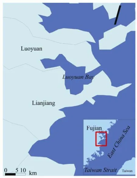
Fig.1 Diagrammatic sketch of Luoyuan Bay (LB).
Serious environmental problems have been caused by the increased discharge of pollutant loadings into LB (Liet al., 2003; Wanget al., 2006). These environmental problems have been reported by local studies, particularly with respect to environmental capacity of LB. Linet al., (2006) estimated the chemical oxygen demand (COD) of discharge from non-point sources into LB, which provides the scientific basis for calculating the environmental capacity and implementing the total pollutant load control of the bay. Likewise, Yuet al., (2010) established a numerical model of the tidal current field as well as a water quality model to calculate the environmental capacity of COD. These studies provide a solid foundation for understanding the environmental conditions and capacity of LB. Other models have been used to quantify the environmental capacity and proved suitable for the implementation of TPLC (Dukaet al., 1996; Erturket al., 2004; Kimet al., 2004; Haralambideset al., 2008; Wuet al., 2012; Liet al., 2013). To the best of our knowledge, the environmental capacity of COD has previously been studied for LB, but the allocation of its environmental capacity, which is more crucial for TPLC, has yet to be explored. Thus, this paper aimed to develop a coupled three-dimensional (3D) hydrodynamic transport-transformation model based on a finite-volume coastal ocean model (FVCOM) for LB. The proposed model can be used to simulate and quantify the physical and biochemical processes in LB as well as the effect of their interactions with the spatial and temporal distributions of the COD concentration. The model could likewise be used to calculate the environmental capacity of COD in LB. Finally, a TPLC scheme based on the maximum allowable loading amount was proposed for the coastal water quality and quantity management of LB.
2 Field Surveys and Environmental Assessment
Topographic characteristics and administration boundaries show that the pollutants are discharged in areas delineated by the catchment basin, which may be further divided into 12 discharge units by ArcGIS (a GIS software program). The 12 discharge units are shown in Fig.2. A comprehensive interdisciplinary survey was conducted in LB on July 2009, in which terrestrial pollution was surveyed at 23 stations (Fig.3), whereas a water quality survey was conducted at 21 stations in LB (Fig.4). The results of the terrestrial pollution survey of COD are presented in Table 1. The mariculture status quo in LB is characterized by the COD discharge from fish, shrimp, and crabs (Table 2). The total discharge amounts of COD into LB are described by Table 3. The terrestrial pollutants only account for 7.9% of the COD, as shown in Table 3. The sea source of COD is the main source in LB. Fig.5 shows the distribution of COD in LB according to the water quality survey. The concentration range was from 0.08 mg L-1to 1.4 mg L-1with a mean value 0.492 mg L-1, meeting the seawater quality standard GradeⅡ(3 mg L-1). Overall, the high value areas were located in the northern part of the bay mouth.

Table 1 Amount of COD discharged (t year-1) by 12 discharge units around LB
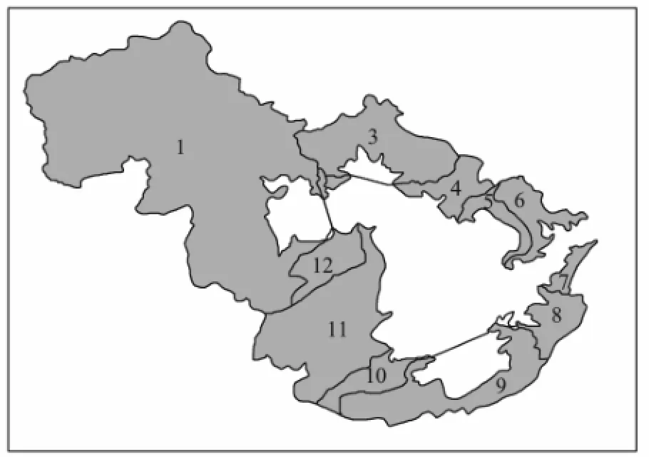
Fig.2 Diagrammatic sketch of discharge units.
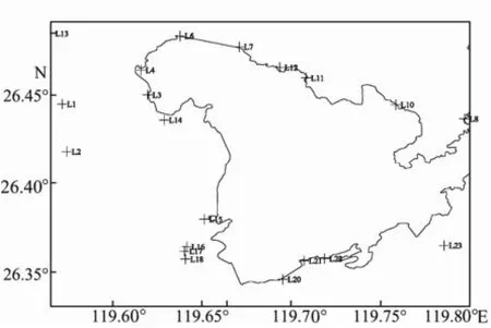
Fig.3 Investigation stations of terrestrial pollution in LB.

Fig.4 Investigation stations for the water quality survey in LB.

Fig.5 The distribution of COD concentrations in the LB.

Table 2 Amount of COD discharged (t year-1) from fish, shrimps, and crabs in LB

Table 3 COD of total pollutants (t year-1) in LB
3 Results and Discussion
3.1 Physical Model
FVCOM is a 3D hydrodynamic model with a high resolution, unstructured triangular grid and a free surface (Chenet al., 2003; Chenet al., 2007; Dmitry and Steven, 2011; Geet al., 2012; Wanget al., 2011). The model simulates water surface elevation, 3D velocity, temperature, salinity, sediment, and water quality constituents in an unstructured triangular grid in the lateral plane and an σ-stretched coordinate in the vertical plane. FVCOM has been used to simulate circulation and transport processes in many estuaries, coastal waters, and open oceans (Zhenget al., 2003; Zhaoet al., 2006; Yang and Khangaonkar, 2009). A 3D hydrodynamic water quality model was constructed using FVCOM for the numerical simulation and study of the LB hydro-environment. The overall view of the study area and the grid pattern used in this study is shown in Fig.6. The horizontal resolution of these unstructured grids ranges from 80 m in the Kemen channel of the LB mouth to 2000 m at the open boundary. The grid resolution is gradually reduced away from the inner bay to the open boundary to maintain the computational efficiency of the model. The triangular grids describe the complex coastlines and topographical features, as illustrated in Fig.5. A total of 29588 nodes and 55363 cells are present in the entire computational domain, with 16633 nodes and 31123 cells specifically in LB and 6 σ levels in the vertical direction. The time step of each model run is 1 s. The detailed description of this model can be obtained in Chenet al. (2003).
The open boundary has an essential role in the calculation of the model; its accuracy directly affects that of the model. In this study, an arch in the open ocean far from LB was chosen as the model’s open boundary. Due to the lack of survey data on the chosen boundary, we directly interpolated the tidak forcing based on the five constituentsS2,M2,N2,K1, andO1to the nodes of the open boundary. These driving data were provided by the Big Area Tidal Model of the China Sea. We chose this model because it is regarded as an ideal numerical model of China’s coastal water bodies, with the highest resolution from 1.5 km to 50 km. The said model achieved satisfactory simulation results. The bathymetry data of the model domain were obtained from the investigation and sea chart published by the Navigation Guarantee Department (NGD) of the Chinese Navy Headquarters. The depth of each grid was calculated by interpolating the above-mentioned data. We considered the zero-m isobaths of high tide as the boundary. The model was run based on the following assumptions. First, the initial ocean is considered static. Thus, the sea level and velocity at the nodes in this study area are zero. Second, the model is barotropic. Consequently, the model was initialized with homogeneous salinity (S= 30.0) and temperature (T= 20℃) fields in the model domain.

Fig.6 Horizontal grid pattern of the hydrodynamic water quality model for LB.
3.2 3D Hydrodynamic Transport-Transformation Model
The FVCOM model and a systematic analysis of the main COD transport and transformation processes in multiphase environment in LB were used to develop a coupled 3D hydrodynamic transport-transformation model for LB. Using this combined model, we could simulate the spatial and temporal distributions of COD in LB and calculate its environmental capacity.
After separating the COD transport-transformation equation from other water quality components and combining it with the water quality hydrodynamic model, the transport-transformation water quality model of COD was obtained. The COD concentration in the water column can be estimated by the following equation based on conservation of mass:

3.3 Linear Programming Model
The linear programming model has been widely applied to the estimation and allocation of the environmental capacity for rivers and lakes (Liet al., 1999; Xunet al., 2009). In this paper, the model was used to calculate the maximum allowable loading amount of COD, subject to its compliance with environmental standards imposed on the seawater quality control points. The model has an optimization target function and water quality constraint equations. The linear programming model used in the capacity optimization calculation can be expressed as (Appan, 1989; Zhang, 2007; Liet al., 1999)

whereECis the environmental capacity;jFrepresents
the allocation capacity of thejth pollution source;represent the background and standard concentrations, respectively, of theith water quality control point;ijαrepresents the input response coefficient between thejth pollution source and theith water quality control point.mandnare the numbers of water quality control points and pollution sources, respectively.
3.4 Calculation Conditions
Environmental factors include hydrological and meteorological forcing. Hydrological forcing refers to salinity and temperature, whereas meteorological forcing includes wind stress and heat flux among others. The first-type boundary conditions indicate that the COD concentrations of the 15 discharge sources should be used as those on the land boundary. The open boundary condition is specifiedthe outer normal to the openboundary, andNCis the concentration component to normal the boundary.
3.5 Water Quality Control Points and Adopted Standards
The set-up of water quality control points are necessary for calculating the maximum allowable loading amount of COD as such calculation is based on ensuring that the COD concentration of each water quality control point does not exceed the designated water criteria. We set 15 water quality control points in LB, based on the number of pollutant sources and their spatial distribution, as illustrated in Fig.7. The water quality control point standards adopted the functional zonal standards of water in LB.
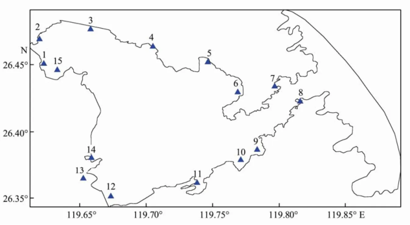
Fig.7 Distribution of water quality control points in LB.
4 Simulation Results
4.1 Simulation of COD Concentrations Distributed in LBThe observed distributions of the spatial and temporal concentrations of COD in LB on July 2007 are illustrated in Fig.8 (upper). The average concentration of COD in LB was 0.16 mg L-1, which is below the Grade II seawater quality standard (3 mg L-1), as defined by the seawater quality standards in China. The spatial distribution of the COD concentrations was higher in the northern regions than in southern regions; the highest values were obtained from the northeast area of LB.
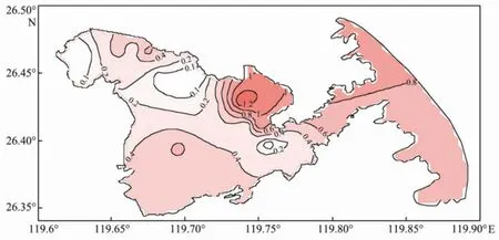
Fig.8 simulation results of COD (mg L-1) in LB on July 2007.
The simulation results of the COD concentration distribution in LB based on the model are shown in the lower portion of Fig.8. The spatial and temporal distribution patterns of COD match the observed results (Fig.5). The concentration values in the eastern and northern regions were relatively higher. The COD concentration in the coastal water column is higher and gradually decreases toward the interior water column. The COD concentration value does not exceed the Grade I seawater quality standard (2 mg L-1) in most of the study area.
4.2 Capacity Allocation and TPLC
The 3D hydrodynamic transport-transformation model was applied to calculate the environmental capacity of COD in LB under a specified grade of the seawater quality standards. The first step was to obtain the individual response fields of pollution sources, and the next step was to calculate the allowed maximum loadings for each source using the linear programming model. The sum of the allowed maximum loadings was designated as theenvironmental capacity of COD.
4.2.1 Responding fields of COD
The water quality of an area is the sum of the individual response fields of all pollutant sources. Therefore, the concentrations of COD in the individual discharge (1 g s-1) from 15 pollutant sources (1 to 15) were respectively simulated. The response field between the open sea (as a source) and the water quality control section was likewise simulated. These simulation results of the COD response fields were based on the assumption that the relationship of the factors with non-seasonal characteristics (phytoplankton and other) and the main transport and transformation processes of COD would not significantly change with seasons. Therefore, the average simulation results were taken as the response coefficient. The response fields of the 16 pollutant sources are shown in Fig.9.
The results showed that given the individual discharge of each pollutant source, the response fields of the concentration of COD are higher in the wastewater outfall and estuary, which decrease gradually towards the surrounding seawaters. The concentration of response field 14 was the highest, whereas that of response field 7 was the lowest. The response fields of the open sea, had concentrations higher than 0.02 mg L-1throughout the bay. The response concentrations close to the discharge from sources 7 and 8 had the highest concentrations, which reached 0.1 mg L-1.


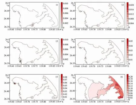
Fig.9 COD (mg L-1) response fields of the 16 wastewater outfalls.
4.2.2 Capacity allocation
The allocation of environmental capacity is one of the most important parts of TPLC and is a precondition for designing TPLC schemes. The above-mentioned linear programming model was used to calculate the environmental capacity and the allowed maximum loadings of 12 discharge units in LB (Table 4). According to the marine functional zoning standards, the results indicated that the environmental capacity of COD in LB is 11×104t year-1. The highest maximum loadings were allowed for discharge unit 5, which accounted for roughly 15.3%; it was followed by discharge unit 3, which accounted for approximately 13.1%. By contrast, discharge unit 11 accounted for only 3.6%.
4.3 TPLC in LB
The targeted reduction of discharge loadings should be established. The remaining excess environmental capacity can be obtained by subtracting the COD results of each actual discharge unit in 2008 from the allowed maximumloads. The calculation results (Table 5) showed that a positive value indicates an available environmental ca-pacity, whereas a negative value implies no environmental capacity being remaining. All discharge units had a positive environmental capacity based on the marine functional zoning standards, except for discharge units 1 and 11, where it is required to reduce their discharge amounts to 996 and 3236 t year-1, respectively.

Table 4 Environmental capacity and allowed maximum load of COD for 12 discharge units in LB under marine functional zoning standards
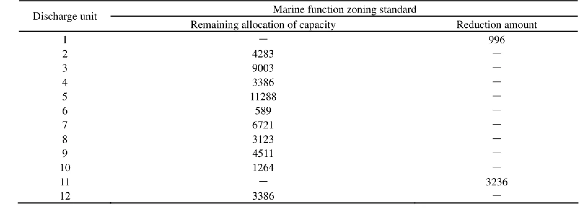
Table 5 Remaining allocation of environmental capacity and required reduction of COD for 12 discharge units in LB
5 Conclusions
A coupled 3D hydrodynamic transport-transformation model was used to calculate the environmental capacity and allowed maximum loads in LB. The model predictions for the spatial and temporal distributions of COD matched the observed results. The environmental capacity and allowed maximum loadings of each discharge unit were obtained, according to the calculated response fields. The environmental capacity of COD in LB was approximately 11×104t year-1. Given that the sea source COD is the main source in LB, mariculture- and domestic-based COD loads should be reduced to meet the targeted water quality criteria. Based on the marine functional zoning standards, discharge loads from discharge units 1 and 11 should be reduced to 996 and 3236 t year-1, respectively.
Acknowledgements
The authors would like to thank Dr. Xianwen Bao for providing the hydrodynamic model (FVCOM) for LB, and Dr. Dehai Song for his assistance in modelling. This work is supported by the Science Fund Projects of Shandong Province (ZR2010DM005), the State Ocean Administration of China ‘908’ Foundation (908-02-02-03), and the Science and Technology Development Plan of Qingdao (11-2-3-66-nsh and 11-2-1-18-hy).
Appan, A., 1989. Water quality management in unprotected catchments-the total approach. Environmental Software, 4: 168-178.
Chen, C., Liu, H., and Beardsley, R. C., 2003. An unstructured, finite-volume, three-dimensional, primitive equation ocean model: Application to coastal ocean and estuaries. Journal of Atmospheric and Oceanic Technology, 20: 159-186.
Chen, C., Huang, H., Beardsley, R. C., Liu, H., Xu, Q., and Cowles, G., 2007. A finite-volume numerical approach for coastal ocean circulation studies: Comparisons with finite-difference models. Journal Geophysics Research, 112, C03018, DOI: 10.1029/2006JC003485.
Dmitry, S. D., and Steven, L. M., 2011. Simulation of the Hurricane Dennis storm surge and considerations for vertical resolution. Natural Hazards, 58: 511-540.
Duka, G. G., Goryacheva, N. V., and Romanchuk, L. S., 1996. Investigation of natural water self-purification capacity under simulated conditions. Water Resource, 23 (6): 619-622.
Erturk, A., Ekdal, A., Gurel, M., Yuceil, K., and Tanik, A., 2004. Using of mathematical models to estimate the effect of nutrient loadings on small streams. Fresenius Environmental Bulletin, 13 (11b): 1350-1359.
European Union, 2000. Directive 2000/60/EC of the European parliament and of the council of 23 October 2000 establishing a framework for community action in the field of water policy. CELEX-EUR official Journal, 12: 1-72.
Ge, J. Z., Chen, C. S., Qi, J. H., Ding, P. X., and Robert, C. B., 2012. A dike-groyne algorithm in a terrain-following coordinate ocean model (FVCOM): Development, validation and application. Ocean Modelling, 47: 26-40.
GESAMP (Joint Group of Experts on the Scientific Aspects of Marine Pollution), 1986. Environmental capacity, an approach to marine pollution prevention. GESAMP Reports and Studies No.30.
Haralambides, L., and Sakellariadou, F. L., 2008. A pollutant dispersion model for the Piraeus, Lavrio and Rafina ports and the Elefsis Gulf. Fresenius Environmental Bulletin, 17 (10a): 1607-1614.
Ji, M., Sun, Z. W., Wang Z. L., and Tao, J. H., 1999. A simulation experiment of the biodegradation process of COD from ocean outfall discharge in Bohai Bay. Oceanologia et Limnologia Sinica, 30 (6): 731-736 (in Chinese with English abstract).
Kim, D. M., Nakada, N., Horiguchi, T., Takada, H., Shirashi, H., and Nakasugi, O., 2004. Numerical simulation of organic chemicals in a marine environment using a coupled 3D hydrodynamic and ecotoxicological model. Marine Pollution Bulletin, 48: 671-678.
Li, K. Q., Su, Y., Ying, J., Wang, X. L., and Mu, J. B., 2013. Environmental capacity of petroleum hydrocarbon pollutants in Jiaozhou Bay, China: Modeling and calculation. Journal of Ocean University of China, 12 (1): 70-76.
Li, S. Y., Li, Y. C., Chen, B. L., and Wu, Q. H., 1999. A new approach to determining environmental capacity of coastal waters. Environmental Science, 20 (4): 96-99 (in Chinese).
Liang, B., and Wang, X. Y., 2005. The current situation and expectation of our country water environment contamination gross control. Journal of Capital Normal University, 26 (1): 93-98.
Lin, Z. L., Yu, X. G., and Liu, X., 2006. Estimation of COD discharge from non-point pollution into Luoyuan Bay. Journal of Oceanography in Taiwan Strait, 25 (2): 209-213.
Meng, W., Zhang, N., Zhang, Y., and Zheng, B. H., 2007. The study on technique of basin water quality target management I: Pollutant total amount control technique in control unit. Research of Environmental Sciences, 20 (4): 1-8.
Nilsson J., and Grennfelt, P., 1988. Critical loads for sulphur and nitrogen. UNECE/Nordic Council workshop report, Skokloster, Sweden, 1-14.
USEPA (United States Environmental Protection Agency), 2008. Total maximum daily loads (TMDLs): A watershed planning tool for counties, DOI: http://www.epa.gov/owow/tmdl.
Wang, J. H., Shen, Y. M., Zhen, H., Feng, Y., Wang, Z. X., and Yang, X., 2011. Three-dimensional numerical modelling of water quality in Dahuofang Reservoir in China. Science China Physics, Mechanics and Astronomy, 54 (7): 1328-1341.
Wang, X. L., Li, K. Q., and Shi, X. Y., 2006. The Marine Environmental Capacity of Major Pollutants in Jiaozhou Bay. Science Press, Beijing, 293pp.
Wu, S. L. Y., Chen, C. S., Gao, P. F., Shi, M. C., Qi, J. H., and Ge, J. Z., 2011. A FVCOM-based unstructured grid wave, current, sediment transport model, I. Model description and validation. Journal of Ocean University of China, 10 (1): 1-8.
Xun, F. F., Ge, Y. J., and Ma, J. Y., 2009. Application the linear programme to calculate water environmental capacity. Journal of Water Resources and Water Engineering, 20 (5): 180-182.
Yang L., and Wang, X. Y., 2008. Control system for total amount of pollutants in waste water. The Administration and Technique of Environmental Monitoring, 20 (3): 16-19.
Yang, Z., and Khangaonkar, T., 2009. Modeling tidal circulation and strati fi cation in Skagit River Estuary using an unstructured grid ocean model. Ocean Modelling, 28: 34-49, DOI: 10.1016/ j.ocemod.2008.07.004.
Yu, X. G., Chen, B., and Wang, J. K., 2010. Study of Gulf Environmental Capacity and Environmental Protection: A Case of Luoyuan Bay. Ocean Press, Beijing, 132pp (in Chinese).
Zhang, G. Z., 2007. Linear Programming. Wuhan University Press, Wuhan, 370pp (in Chinese).
Zhao, L., Chen, C., and Cowles, G., 2006. Tidal fl ushing and eddy formation in Mount Hope Bay and Narragansett Bay: An application of FVCOM. Journal of Geophysical Research, 111, C10015, DOI: 10.1029/2005JC003135.
Zheng, L., Chen, C., and Liu, H., 2003. A 3-D modeling study of the Satilla River Estuarine System. Part I: Simulation of fl ooding/drying processes, Estuaries, 26 (3): 651-669.
(Edited by Ji Dechun)
(Received April 18, 2013; revised November 1, 2013; accepted May 14, 2014)
© Ocean University of China, Science Press and Springer-Verlag Berlin Heidelberg 2014
* Corresponding author. Tel: 0086-532-66786355
E-mail: likeqiang@ouc.edu.cn
杂志排行
Journal of Ocean University of China的其它文章
- Numerieal Prediction of Storm Surge in the Qingdao Area Under the Impact of Climate Change
- Warmer-Get-Wetter or Wet-Get-Wetter? A Criterion to Classify Oceanic Precipitation
- Modeling Seasonal Variations of Subsurface Chlorophyll Maximum in South China Sea
- Assimilation of High Frequency Radar Data into a Shelf Sea Circulation Model
- A Physics-Based Dual-Frequency Approach for Altimeter Wind Speed Retrieval
- CFD-Based Numerical Analysis of a Variable Cross-Section Cylinder
