Study on dynamic changes of land desertification in the circum-lake zone of the Qinghai Lake in the past 30 years supported by Remote Sensing and Geographical Information System
2014-03-31MengJunHuWenLiZhangAiLiYangLiHuiTianDengShanZhang
MengJun Hu, WenLi Zhang, AiLi Yang, LiHui Tian, DengShan Zhang
1. College of Geography and Environment Science, Northwest Normal University, Lanzhou, Gansu 730070, China
2. Ministry of Education Key Laboratory of Environmental Change and Natural Disaster, Beijing Normal University, Beijing 100875, China
Study on dynamic changes of land desertification in the circum-lake zone of the Qinghai Lake in the past 30 years supported by Remote Sensing and Geographical Information System
MengJun Hu1*, WenLi Zhang1, AiLi Yang1, LiHui Tian2, DengShan Zhang2
1. College of Geography and Environment Science, Northwest Normal University, Lanzhou, Gansu 730070, China
2. Ministry of Education Key Laboratory of Environmental Change and Natural Disaster, Beijing Normal University, Beijing 100875, China
The circum-lake zone of the Qinghai Lake is one of the most serious regions of desertification on the Qinghai-Tibetan Plateau. Based on Remote Sensing (RS) and Geographical Information System (GIS) techniques, the four sets of remote sensing images acquired in 1976, 1987, 1995, and 2006 were selected to conduct thematic information extraction in 14,300 km2of land in the circum-lake zone using the Earth Resource Data Analysis System (ERDAS) image and information processing function. In the meantime the off-site interpretation and filed check-correction methods were used to reconstruct the temporal-spatial dynamic changes and differentiation patterns of land desertification in the circum-lake zone in the past 30 years, and based on this, the developmental trend of land desertification in the next 20 years was predicted. The results of the study show that in the past 30 years land desertification in the region experienced a continuous fluctuation between rapid- and slow-development processes in time, while in space it exhibited a few small patchy distributions or sporadic distributions in many places while at the same time, four large sand-dominated distributions stood out and evolved into a circum-lake belt differentiation pattern with a lakeside dike as the connecting line. Due to the integrated effects of climate changes, human activities and artificial rehabilitation, land desertification area in the region in the next 20 years will exhibit an increasing trend in the first 15 years and then increase at a slower rate, and afterward occur in a reverse, decreasing trend.
Qinghai Lake; land desertification; dynamic change; RS; GIS
1 Introduction
Qinghai Lake is the largest plateau, inland salt-water lake of China. In the past 30 years, with regional climate changes and increasingly aggravating human activities, land desertification in the circum-lake zone of the Qinghai Lake has expanded rapidly, exhibiting a ring-belt spread around the lake and forming four large area of sand zones,i.e., the Ganzihe sand zones to the east and northeast of thelake, the Bird Island sand zone at the northwest shore of the lake, and the Langmashegang sandy area in the circum-lake zone, where desertification was first initiated in the early 1960s (Lanzhou Institute of Geology, 1979; Zhenet al., 1985). Beginning in the 1980s many scholars adopted field investigation, fixed site observation and experimental methods to generally analyze and study the cause, status and damage degree of aeolian sand deposition at the east shore of the Qinghai Lake and land desertification on the outskirt of the lake (Xu and Xu, 1983; Heet al., 1993; Zhang, 1993; Zhaoet al., 1993). In the 1990s researchers used remote sensing techniques to study the ecological environment, grassland resources, lake changes, stratification of the lake body, land use and land desertification in the region (Yu and Chen, 2002; Xu and Hou, 2005; Jianet al., 2006; Zhou, 2007; Shaet al., 2010). Rapid extension expansion of land desertification severely weakens the functions of the Qinghai Lake, in enriching the biodiversity of the Qinghai-Tibetan Plateau, regulating the climate in Northwest China, conserving water resources and maintaining ecological balance (Zhanget al., 2009). The four sets of remote sensing images acquired in 1976, 1987, 1995 and 2006 were selected to use the ERDAS-supported spectral classification method and ArcGIS-provided intersection superimposition method to analyze and reconstruct the temporal-spatial variation processes of land desertification in the circum-lake zone in the past 30 years. Based on this, the developmental trend of land desertification of the region in the next 20 years was predicted, so as to provide some basic data and rehabilitation guidance for the eco-environmental reconstruction and protection of the Qinghai Lake and its surrounding region.
2 Natural conditions of the circum-lake zone
The circum-lake zone of the Qinghai Lake (36°28′N-38°25′N, 97°53′E-101°13′E) is located at the northeast corner of the Qinghai-Tibetan Plateau, including parts of villages of Haiyan county and Gangcha county of the Haibei Tibet Autonomous Prefecture, and parts of Gonghe county of the Hainan Tibet Autonomous Prefecture. About 120 km wide from south to north and 160 km long from east to west, the zone contains the Qinghai Lake, covering a total area of 14,271.9 km2(Figure 1). The circum-lake zone borders the Qinghai South Mountain to the south, Riyue Mountain to the east, Amniniku Mountain to the west (the east border of Tianjun county is the west limit of the study area), and Datong Mountain to the north, creating a relief that is high in the northwest and low in the southeast, to form an isolated and closed intermontane inland basin. Located in the interior of the Eurasia, at the junction of the east monsoon zone and the Qinghai-Tibetan Plateau monsoon region, the region forms an alpine frost semiarid steppe climate with sparse precipitation, perennial Westerlies, frequent dry wind, intense solar radiation and large annual air temperature range, and is affected by topography, altitude and atmospheric circulation. Due to complex and variable topography and habitat conditions, vegetation types in the lake region are diverse, with temperate vegetation and alpine frost vegetation coexisting. The lake basin is dominated by steppe vegetation while the mountains are covered by various alpine frost vegetation. The landscape of vegetation in the lake region on the whole exhibits an evolutionary trend towards alpine frost desertification (Zhenet al., 1985).
3 Study methods
3.1 Formulation of classification indicators of land desertification in the circum-lake zone of the Qinghai Lake
Land desertification degrees are classified according to the remote sensing survey criteria of land desertification formulated in the "National Desertification and Sandification Monitoring Technical Specification" published by National Forestry Bureau in 2004 (Zhanget al., 2003) in combination with the observed condition in the circum-lake zone. Land desertification degrees are divided into very severe, severe, moderate and slight desertification. The remote sensing survey classification system of land desertification is shown in table 1.
3.2 Data selection and processing
According to the research target of the temporal-spatial evolutions of land desertification in the monitoring circum-lake zone of the Qinghai Lake, two scenes, each of four intervals, of Landsat images of the Qinghai Lake of orbital number 133/34 and 133/35 were selected, to obtain the remote sensing images of the Qinghai Lake Basin by using ERDAS-supported "multiband data combination" and "image montage" techniques. Furthermore, a 1:50,000 topographic map of Guinan county and 90m×90m grid data were used to delimit the study range and cut out the remote sensing images of the circum-lake zone. The selection of the seasonal phase of TM images can significantly affect how land desertification is monitored. June-September is the season with best vegetation cover of the Qinghai Lake region. With the presence of crops in cultivated fields helping to circumvent the overestimation of land desertification in the season of sparse vegetation. Additionally, the deserti-fied land, cultivated land, forest land and grassland can be easily distinguished on images. Therefore, the remote sensing images acquired in August were selected as the data source.
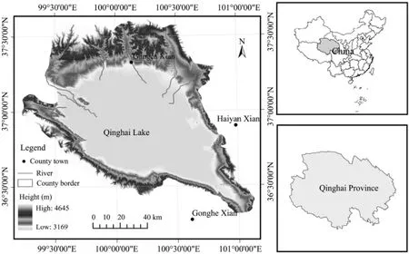
Figure 1 Location of the study region
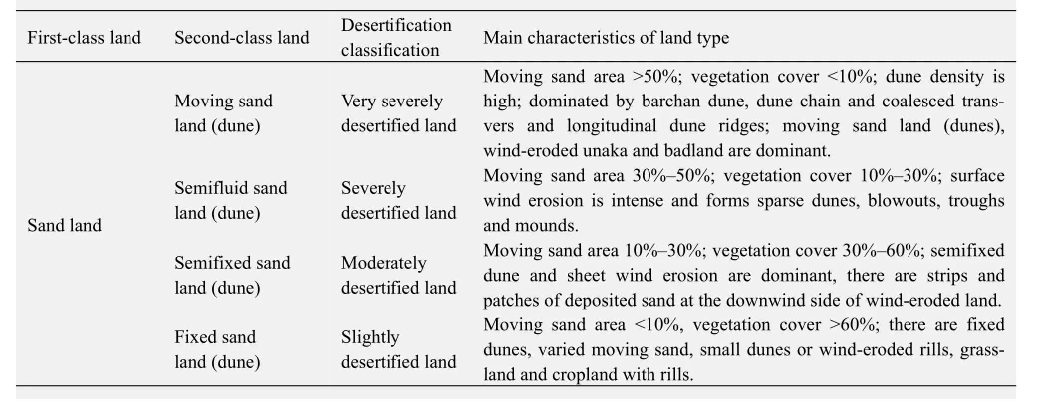
Table 1 Classification indicators of land desertification in the circum-lake zone of Qinghai Lake
3.3 Establishment of interpretation marks of land desertification in the circum-lake zone
Interpretation marks refer to the image characteristic of remote sensing images used to reflect or judge ground objects or phenomena. In this study the interpretation elements, image types, season, scale, geographic zone, study object, andetc.are integrated to establish the following interpretation marks of land desertification in the circum-lake zone (Table 3).
3.4 Geographical analysis of GIS and land transfer analysis
Supported by ERDAS and combined with field surveys and other written information, the direct spectral classification method was used to extract the dynamic variation information of land desertification in the study region through visual interpretation of various periods of remote sensing images in accordance with the classification criteria in table 3.
The ArcGIS-offered INTERSECT (intersection) superimposition method was used to produce data statistics based on the superimposed analyses of four sets of vectoring image data, thus obtaining transfer data of various land types over the four intervals of the past 30 years and subsequently establishing the transfer matrix of land types. Based on this, the transfer amount and transfer direction of land desertification in the circum-lake zone of the Qinghai Lake in the past 30 years were analyzed to reconstruct the temporal-spatial development and the evolutionary processes of land desertification.
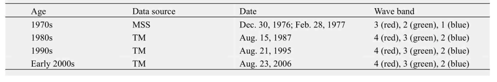
Table 2 Multiphase database of monitoring land desertification in circum-lake zone of the Qinghai Lake
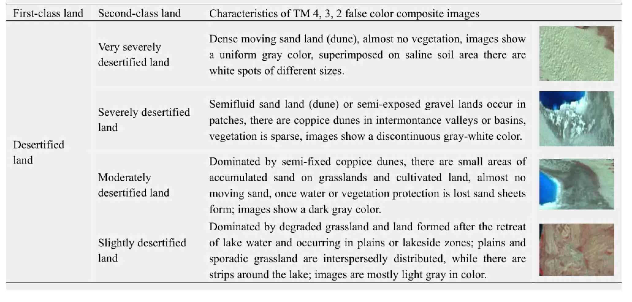
Table 3 Interpretation marks of TM images (RGB=band 4, 3, 2) for land desertification in the circum-lake zone of Qinghai Lake
4 Analysis of results
The above-mentioned methods and classification criteria were used to interpret the four intervals of images in the circum-lake zone and establish the temporal-spatial variation database of different land-use types (Figure 2). Based on this the dynamic changes of land desertification in the circum-lake zone were analyzed and discussed.
4.1 Temporal-spatial variations of land desertification in the circum-lake zone in the past 30 years
4.1.1 Status of land desertification
In total, there were 1,358.02 km2of desertified land in the circum-lake zone in 2006, accounting for 9.52% of the total area of the circum-lake zone, of which very severely, severely, moderately and slightly desertified lands occupied 18.16%, 14.90%, 23.28% and 43.66% respectively of the total area of desertified land. There is 55.45% of desertified land occurred in Haiyan county, another 22.43% and 21.65% of desertified land occurred in Gangcha county and Gonghe county. These desertified areas exhibited a ring-belt spread around the Qinghai Lake and were distributed in a concentrated pattern to form a large area of sand to the east of the lake, the Ganzihe sand zone to the northeast of the lake, the Bird Island sand zone at the northwest shore of the lake and the Langmashegang sand zone at the southeast edge of the lake.
4.1.2 Temporal variations in land desertification area
Four intervals of land desertification maps were used to reconstruct the temporal-spatial evolution of land desertification in the circum-lake zone in the past 30 years (Table 4, Figure 2). The total areas of land desertification in the circum-lake zone of the Qinghai Lake in 1976, 1987, 1995 and 2006 were 738.58, 962.59, 1,044.07 and 1,358.02 km2respectively, accounting for 5.18%, 6.74%, 7.32% and 9.52% of the area of the circum-lake zone respectively. The annual mean increased area of land desertification showed that land desertification expansion in the past 30 years experienced a fluctuating process of rapid increase of desertification to slow increase to rapid increase once again. During the 1976-1987 period the desertification area in the circum-lake zone showed a net increase of 224.01 km2, with the annual expansion rate at 2.76%. So far as the different degrees of land desertification are concerned, the area of very severely desertified land stayed relatively constant, while the severely, moderately and slightly desertified lands increased to different degree, expanding by 7.07, 0.58 and 205.73 km2respectively. This shows that during this period land desertification in the circum-lake zone expanded rapidly, with a severe desertification phenomenon, dominated by the expansion of slight desertification. During the 1987-1995 period the area of land desertification in the circum-lake zone increased by 81.48 km2, while its annual mean expansion rate significantly slowed compared to the previous 10 years, with only a 1.06% increase. Very severely desertified land exhibited a reversal of desertification as its area decreased by 3.38 km2, while the areas of severely, moderately and slightly desertified lands increased by 13.45, 15.93 and 55.49 km2respectively. As compared to previous stages, the expansion rate of land desertification decelerated. However, the severe and moderate desertification expanded rapidly, although the rate of expansion of slightly desertified land significantly decreased. During the 1995-2006 period the expanded area of land desertification in the circum-lake zone reached 313.95 km2and its annual mean expansion rate significantly accelerated compared to previous stage, reaching 2.73%. In this period the area of severely desertified land decreased by 2.91 km2but the areas of very severely, moderately and slightly desertified lands increased by 0.47, 78.73 and 237.65 km2, respectively. The expansion of land desertification was dominated by moderate to slight degrees of desertification, but the situation was still quite serious. In summary, during the 30-year period from 1976 to 2006 land desertification in the circum-lake zone exhibited a continuous expansion trend.
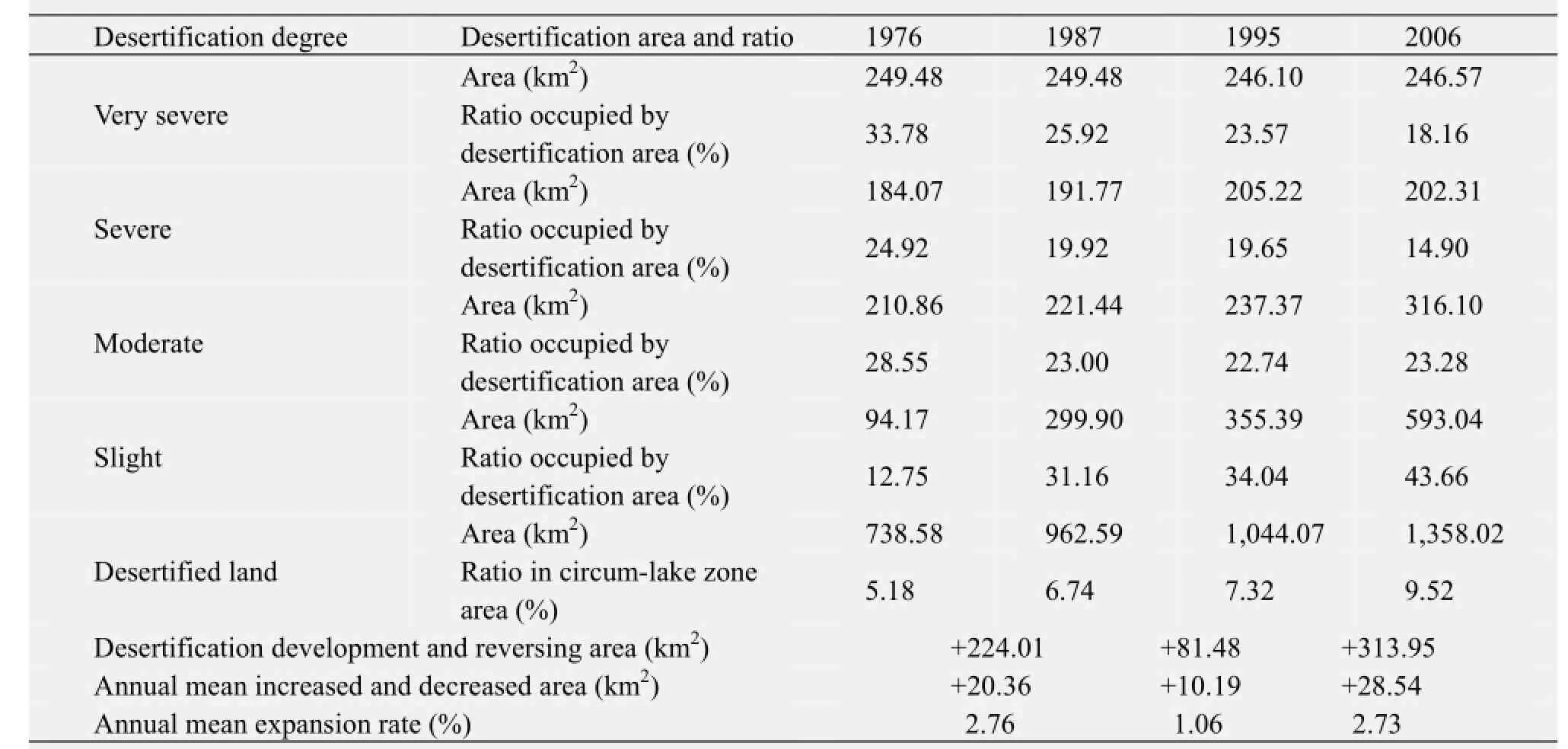
Table 4 Variations in area and degree of land desertification in the circum-lake zone in the past 30 years
4.1.3 Spatial changes of land desertification and regional differentiation
As viewed from nearly 30 years of formation and evolution, land desertification in the circum-lake zone of the Qinghai Lake mainly occurred in three counties, Haiyan, Gangcha, and Gonghe, and formed four large areas of sand zones,i.e., the sand zone to east of thelake, the Ganhezi sand zone to the northeast of the lake, the Bird Island sand zone at the northwest shore of the lake and the Langmashegang sand zone at the southeast edge of the lake basin. The distribution pattern of land desertification rapidly turned from a discontinuous distribution in 1976 into a ring-belt spread around the Qinghai Lake over time (Figure 2). In 1976 there was only one large area of desertified land located to the east of the lake, while in other zones there were small areas of sandy mosaic patches on the grassland in the circum-lake zone. Additionally, the Haiyanwan Lake in the east of the Qinghai was still an open lake. In 1987 the area of slightly desertified land to the east and northeast of the lake expanded rapidly, the Haiyanwan lake was enclosed by sand dike to form sublakes, and in the southwestern part of the Shadao Lake a large sand dike formed. In the Ganzihe sand zone to the east of the lake a large patch of slightly desertified land was observed. In 1995 the area of the Ganzihe sand zone further expanded and exhibited a continuous distribution, while the land desertification in the delta of the Shaliu River and Buha River of the Shadao Lake spread towards the center of the lake. In 2006 the typical ring-belt distribution pattern formed around the lake, dominated by four large sand zones with the lakeside sand dike as the connecting line, of which the Langmashegang sand zone became one of the newest sand zones that rapidly expanded in the past 30 years. The water surface of the Shadao Lake significantly decreased compared to its previous state, and there was a trend to form new sublakes of the Qinghai Lake between the Shadao Lake and the Haiyanwan Lake. Very severely desertified land was concentrated in the sand zone to the east of the lake, while severely desertified land mainly appeared in the Bird Island sand zone at the northwest shore of the lake and in the Ganzihe sand zone to the northeast of the lake. Slightly desertified land expanded rapidly in the last 30 years and became the main class of other sand zones, except the sand zone to the east of the lake.
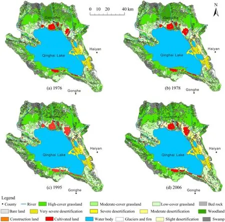
Figure 2 Temporal-spatial changes of land desertification in the circum-lake zone of the Qinghai Lake in the past 30 years

Table 5 Changes in land desertification area in various counties in the circum-lake zone in the past 30 years
The bulk of land desertification in the circum-lake zone occurs in the Haiyan county, while Gangcha county and Gonghe county have a relatively small area of desertified land. During the 1976-2006 period desertified land area in various counties exhibited a continuous increasing trend but the rate of increase in different years was slightly variable. Therefore, the percentage of desertified land area in the region of the circum-lake zone underwent significant change (Table 5). As a whole, the percentage of land desertification in Haiyan county and Gonghe county in the circum-lake zone slightly decreased, but, on the other hand, it significantly increased in Gangcha county of the circum-lake zone.
To precisely reflect the regional differences of land desertification, the concept of relative variation is introduced (Desertification Control Office of Forestry Ministry of China, 1996; Zhu and Li, 2003):

whereKris the relative variation rate of land desertification;K1andKaare the dynamic degree of local and all land desertification respectively;UaandUbare the local desertified land areas at the beginning and end of this study, respectively;CaandCbare the desertified land area in the whole study region at the beginning and end of this study, respectively.
From the calculation, the relative variation rates of desertification in Haiyan, Gangcha and Gonghe counties in the past 30 years were obtained, of which the relative variation rate of land desertification in Gangcha county was the largest, reaching 2.51, suggesting that the regional variability of land desertification was highest here. The relative variation rate of land desertification in Haiyan county was 0.84 and its regional variability was the second highest; the relative variation rate of land desertification in Gonghe county was 0.58 and its regional variability was the lowest in the cirum-lake zone of the Qinghai Lake.
4.2 Transfer analysis of land desertification
A transfer matrix can comprehensively and concretely describe the structural characteristics of regional landuse changes and the direction of transfer of various landuse types. It is convenient to understand and study the direction of lossing land of various landuse types at the beginning and the source and composition of various landuse types in the later period (Wang and Bao, 1999; Chen, 2002; Liu and He, 2002; Zenget al., 2003; Zhu and Li, 2003; Han and Chang, 2004; Zheng, 2006). Based on the four intervals of the map of landuse type and attribute table, the ArcGIS was used to generate INTESECT calculations to obtain the transfer matrix between desertified land and other land type in the three intervals, 1976-1987, 1987-1995 and 1995-2006, in the circum-lake zone (Table 6).
4.2.1 Transfer of different classes of desertified land
During the 1976-1987 period very severely desertified land did not convert to other desertified land types, 1.74% of severely desertified land became moderately desertified land, 1.45% converted to slightly desertified land, and 4.53% of moderately desertified land became severely desertified land (Table 6). It can be seen that the speed of development of moderate desertification was greater than the speed of reversal of severe desertification, and that land desertification exhibited an expansion trend. During the 1987-1995 period 1.69% of very severely desertified land transformed into moderately desertified land, 1.53% of severely desertified land transformed into moderately desertified land, 0.06% of moderately desertified land became very severely desertified land and 5.05% transformed into severely desertified land, and 0.86% of slightly desertified land became moderately desertified land (Table 6). This shows that in this period the development of desertification was pronounced. During the 1995-2006 period very severe desertification showed no change, 0.28% severely desertified land became very severely desertified land and 1.36% became moderately desertified land, 1.90% of moderately desertified land became severely desertified land, 30.40% of slightly desertified land became moderately desertified land and 0.23% became severely desertified land (Table 6). This showsthat the development of desertified land was faster in this stage than in the previous stage.
4.2.2 Inter-transfer between desertified land and other land type
During the 1976-1987 period 6.45% of desertified land transformed into different land types, with a converted area of 47.71 km2; 10.07% of other land types became desertified land, with a converted area of 1,361.44 km2. This was 28.54 times that of other land types transformed from desertified land, as in this period the developmental trend of land desertification was far larger than renewed area of reversed desertification. During the 1987-1995 period 7.55% of desertified land transformed into other land types, with a converted area of 72.67 km2; 4.74% of other land types became desertified land, with a converted area of 631.33 km2, and the expanded area of desertification was 8.69 times that of the renewed area of reversed desertification. It can be seen that in this stage the speed of desertification was reduced compared to previous stage. During the 1995-2006 period 39.71% of desertified land transformed into other land types, with a converted area of 414.60 km2; 33.50% of other land types transformed into desertified land, with a converted area of 4,428.43 km2. The desertified land area was 10.68 times that of the non-desertified area, showing that in this stage land desertification accelerated again.

Table 6 Inter-transfer of different classes of desertified land and other land types in the circum-lake zone in the past 30 years
The above analyzed results show that land desertification in the circum-lake zone in the past 30 years experienced a fluctuating variation process of rapid-slow-rapid development. The conversion processes were dominated by the desertification of surrounding land types, accompanied by the inter-conversion of different classes of desertified lands.
4.3 Dynamic degree of land desertification variation in the past 30 years
Dynamic degrees reflect the area variation amplitude and variation rate of different landuse types in units of time, as well as indicating the difference in type of regional landuse variation (Wang and Bao, 1999; Chen, 2002; Liu and He, 2002; Zenget al., 2003). Desertified land is a land type; its dynamic degree can reflect the variation degree of desertified land in the study period, and its model formula is as follows:
Kis the dynamic degree of a type of desertified land in a region,Uais the area of desertified land at the beginning of the study,Ubis the area of desertified land at the end of the study, andtis the duration of study time. The area data of the four intervals of land desertification variation in the circum-lake zone were substituted into the formula of the dynanmic degree to obtain the general and varied classes of dynamic degree of land desertification in various periods (Figure 3).
Figure 3 shows that during the 1976-1987 period, the dynamic degree of land desertification was 2.76%, while the dynamic degrees of moderate, severe and slight land desertification were 0.38%, 0.46% and 19.81% respectively. This shows that the slight land desertification played a principal role in the land desertification conversion in the period. During the 1987-1995 period, the dynamic degree of land desertification was 1.01%, of which the dynamic degree of very severe land desertification was −0.17%. This shows that very severe desertification showed a trend of reversal in this stage, while the dynamic degrees of moderate, severe and slight land desertification were 0.88%, 0.90% and 2.31%, respectively. This indicates that the leading trend of land desertification in this stage was, from least to greatest, moderate desertification, severe desertification and slight desertification; furthermore, the speed of development of moderate desertification was faster than that of previous stage, while the speed of slight desertification was reduced to a slow rate, and the dynamic degree of land desertification declined. During the 1995-2006 period the general dynamic degree of land desertification rose to 2.73%, of which the dynamic degree of very severe land desertification was 0.02%, in other words its rate of increase was very slow. The dynamic degrees of moderate and severe land desertification were −0.13% and 3.02% respectively, and the dynamic degree of slight land desertification was 6.08%. This shows that moderate land desertification in this stage was reversed while the severe and slight land desertification rose.
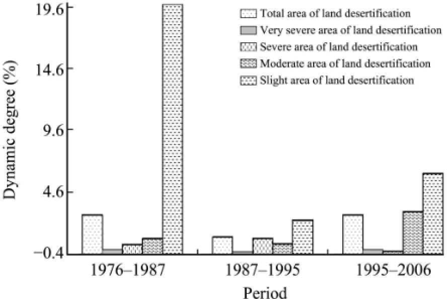
Figure 3 Variations in dynamic degree of land desertification in the circum-lake zone of the Qinghai Lake in the past 30 years
From the calculation and analysis of the dynamic degree of land desertification in the circum-lake zone of the Qinghai Lake, it can be seen that during the 1976-2006 period, the area of land desertification in the zone exhibited an increasing trend. The increasing speed of desertification appeared as a rapidslow-rapid fluctuation trend, of which very severe land desertification showed an unchanging state to reversed desertification to a slowly increasing trend, severe land desertification occurred as a trend of a slow increase in desertification to a rapid increase to a reversal of desertification, moderate land desertification occurred as a trend of slow increase to rapid increase to exceedingly rapid increase of moderately desertified land, and slight land desertification appeared as a trend of extremely rapid increase to slow increase to rapid increase of slightly desertified land.
5 Prediction of the developmental trend of land desertification in the circum-lake zone in the next 20 years
Considerable amounts of the study data (Wanget al., 2003; Sunet al., 2007; Wang and Wang, 2007; Xuet al., 2007; Liet al., 2008; Chenet al., 2009; Liet al., 2010) show that annual mean air temperature in the circum-lake zone of the Qinghai Lake exhibited a fluctuating but rising trend in the past 30-40 years, with about a 0.79 °C increase each decade. This was significantly higher than the 0.44 °C temperature increase each decade in the Qinghai Province, the 0.37 °C increase each decade on the Qinghai-Tibetan Plateau and the 0.35 °C increase each decade in the entire country. In winter, especially, the temperature rise was most evident, and the tendency of temperature variation each decade reached 0.53 °C. Although the annual mean precipitation slightly increased, the number of days without precipitation increased, and the annual mean evaporation exhibited a rising trend. However, due to the combined effects of a number of factors the climate still exhibited a warm-desiccation trend. It is predicted that under the background effects of global warming the climatic pattern and aridity variation in the circum-lake zone of Qinghai Lake will not change greatly in the future, although due to the superimposed effects of human activities, land desertification in the circum-lake zone of Qinghai Lake will exhibit a continuous expansion trend. One can make a directional prediction using the formula (Zhuet al., 1989):
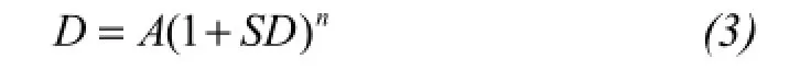
whereDis the area of land desertification in the final year,Ais the area of land desertification in the initial year of the prediction,SDis the dynamic degree (annual increase rate) of land desertification, andnis the predicted years.
Due to the combined effects of natural factors such as air temperature, precipitation, and evaporation (W1), human factors (W2), and control measures (W3), theSDshould be corrected at the time of the prediction. The corrected formula is as follows (Liet al., 2009):
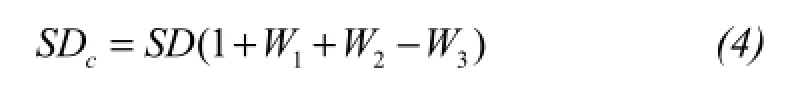
Effect of the natural factor (W1): study data show that the mean air temperature of the Qinghai-Tibetan Plateau rose by −0.8 °C in 2010, the natural cooling effect was followed by a human warming effect and the temperature afterward slowing rose; by 2030 the mean air temperature of Plateau will increase by 0.8-1.2 °C, and by 2050 it will reach 2.2-2.7 °C (Liet al., 2009). Although the precipitation may decrease or increase in the future 20 years, it cannot alter the basic situation of an arid and semiarid climate of the Qinghai-Tibetan Plateau. Therefore, in the prediction of the desertification development trend in the circum-lake zone of the Qinghai Lake in the future 20 years, a 0.02 weighted value of a natural factor is used, introduced in the prediction of land desertification of Tibet (Liet al., 2009).
Effect of human activities (W2): Assuming that the population growth rate of Qinghai Province is 11.1‰(the average of the country), the weighed value is 0.03. But at the present stage, the population growth rate of Qinghai Province is 8.32‰, then the weighed value is 0.0227; assuming that as the GDP increase rate is 5%, the weighed value is 0.03. The 10-year GDP mean increase rate, 12.35%, of Qinghai Province is used as the GDP increase rate of the region in 2006-2007 period, so the weighed value is 0.0741. Hence, the weighed value of human activities is 0.0968.
Effect of control measures (W3): The main measures to control land desertification include regional ecological construction, desertification control projects, grassland management and development management, andetc.. According to survey, the rehabilitation effect of desertification in the circum-lake zone of the Qinghai Lake in recent years is quite remarkable, so the set weight with the largest influence in the calculation is 0.5.
Therefore, the weights representing the effects of natural factors, human activities and control measures onSDvalue are 0.02, 0.0968, and 0.50, respectively. According to the annual dynamic degree, during the 1995-2006 period the annual mean expansion rate of land desertification was 2.73%. Accordingly, the correctedSDvalue was used to predict the land desertification development variation in the circum-lake zone of Qinghai Lake in the next 20 years.
The predicted results show that desertification areas in the circum-lake zone of the Qinghai Lake in 2011, 2016, 2021 and 2026 are 1,476.27, 1,604.82, 1,744.56 and 1,370.55 km2respectively, an increase of 188.25, 246.80, 368.54 and 12.54 km2respectively compared to 2006. The annual mean expansion area of desertification is 19.15 km2, which corresponds to 0.60% of the annual mean expansion area of land desertification in the country. It can be concluded from the predicted results that the area of land desertification in the circum-lake of Qinghai Lake in the 15-year period from 2006 to 2021 exhibits a rapid increase trend, but after the year 2021 its increased area decreases sharply. As viewed on the regional scale, through rehabilitation the land desertification in Haiyan and Gonghe counties approaches a roughly stable state, but on the other hand, Gangcha County remains the key site of land desertification in the circum-lake zone, as its expansion area occupies 74.4% of the total expansion area of the circum-lake zone.
6 Conclusion and discussion
The study results show that in the past 30 years land desertification in the circum-lake zone of Qinghai Lake rapidly expanded, and its desertification degree exhibited a fluctuating by exacerbating trend. From 1976 to 2006 the land desertification area increased by 83.87%, with an annual mean increase rate of 2.73%. Its development processes exhibited a rapid-slow-rapid development feature, so that the desertified land is dominated by the desertification of the surrounding land types, accompanied by the inter-transformation of different classes of desertified lands. As viewed from the spatial distribution, the main body of land desertification in the circum-lake zone is in the Haiyan county, but the regional variability is most obvious in the Gangcha county, and in the next 30 years land desertification area may increase by 210.52%.
Under the effects of global warming and superimposed human activities, it is predicted that the land desertification area in the circum-lake zone of the Qinghai Lake will continuously increase in the next 20 years. However, with the further implement of desertification control measures in the circum-lake zone, land desertification will tend to decrease after 2021, showing that the use of artificial measures to control desertification has a certain lag effect.
Studies show that in North China and in the Qinghai Province land desertification has always exhibited an accelerating expansion trend from 1950 to 2000, and starting from the beginning of 21st century land desertification began to be reversed (Wanget al., 2004; Wang, 2008, 2009; Liet al., 2011; Wanget al., 2011). However, there is somewhat of a departure between the studied result and reported data, the reason for this is that, besides the difference in the limit of the study region, there is an inconsistent study interval. During the 1990-2000 period the expansion rate of desertification (3,600 km2/a in North China, 243.7 km2/a in Qinghai Province) was far higher than the decreasing rate at the beginning of 21st century. The conclusion obtained in this study is that deserti-fication in the circum-lake zone was in a state of expansion during the 1995-2006 period, which is consistent with the situation that on the whole, the area of desertification decreases, but on a local scale its area may expand.
Acknowledgments:
The authors are very thankful to reviewers and Professor Sen Li for proposing good suggestions. This study is supported by National Natural Science Foundations of China (Grant Nos. 40761026 and 41161036) and the grant of the Outstanding Youth Foundation Project Program of the Northwest Normal University (No. NWNU-LKON-10-34).
Chen BM, 2002. Establishment and evaluation of the index system frame of regional land sustainable use. Progress in Geographical Science, 21(3): 204-215.
Chen XG, Li L, Zhu XD,et al., 2009. Study of regional difference and cause of climate on the Qinghai-Tibetan Plateau. Progress in Study of Climate Changes, 5(5): 249-254.
Desertification Control Office of Forestry Ministry of China, 1996. The UN Convention to Combat Serious Drought and Desertification in Related Countries Especially in Africa. China Forestry Press, Beijing, China.
Han WQ, Chang Y, 2004. Study of Markor model of landscape dynamics-the case of Changbei: Mountain Nature Reserve. Acta Ecological Sinica, 24(9): 1958-1965.
He DN, Zhao HB, Zhang DS,et al., 1993. Sandy land characteristics and aeolian desertification trend in Qinghai Lake basin. Geographic Science, 13(4): 383-388.
Jian J, Li HJ, Dai XA, 2006, Remote sensing geoscientific analysis of land desertification in Qinghai Lake region. Earth Information Science, 8(2): 116-118.
Lanzhou Institute of Geology, Chinese Academy of Science, 1979. Comprehensive Investigation Report of Qinghai Lake. Science Press, Beijing, China, pp. 1-5.
Li FX, Fu Y, Yang Q,et al., 2008. Climate changes and environmental effect in surrounding region of the Qinghai Lake. Resource Science, 30(3): 348-353.
Li L, Chen XG, Wang ZY,et al., 2010. Study of regional climate changes and difference on the Qinghai-Tibetan Plateau. Progress in Study of Climate Changes, 6(3): 181-186.
Li S, Yang P, Dong YX,et al., 2009. Land Desertification and Its Control in Tibet. Science Press, Beijing, China, pp. 199-218.
Liu SH, He SJ, 2002. Spatial analysis and calculation model of landuse dynamic changes. Journal of Natural Resources, 21(3): 204-215.
Sha ZJ, Li LQ, Shi YF,et al., 2010. Study of contemporary processes of land desertification in the surrounding region of the Qinghai Lake. Qinghai Normal University, Xining, China.
Sun YL, Li XY, Xu HY, 2007. Day-to-day precipitation and air temperature variation features in the Qinghai Lake basin in recent 40 years. Journal of Arid Meteorology, 25(1): 7-13.
Wang JB, Wang ZG, 2007. Study of the characteristics of air temperature changes of northeastern slope of the Qinghai-Tibetan Plateau. Agricultural Research in Arid Areas, 25(1): 176-180.
Wang T, 2008. Thinking of the development of desertification science in China. Journal of Desert Research, 28(1): 1-7.
Wang T, 2009. Progress in desertification research. Bulletin of Chinese Academy of Science, (3): 290-296.
Wang T, Song X, Yan CZ,et al., 2011. Remote sensing analysis of land desertification trend in north China in recent 35 years. Journal of Desert Research, 31(6): 1351-1356.
Wang T, Wu W, Xue X,et al., 2004. Spatial-temporal changes of land desertification in north China in recent 50 years. Acta Geographica Sinica, 59(2): 203-212.
Wang XL, Bao YH, 1999. Discussion on the study method of landuse dynamic changes. Progress in Geographical Science, 18(1): 81-87.
Wang YJ, Zhou XL, Ni SX,et al., 2003. Analysis of climate changes in Qinghai Lake region in recent 40 years. Journal of Nanjing Meteorological College, 26(2): 228-235.
Xu CJ, Hou GL, 2005. Study of sandy land around Qinghai Lake using remote sensing geographical information system. Journal of Qinghai University (Natural Science), 23(3): 63-66.
Xu HY, Li XY, Sun YL, 2007. Analysis of climate changes in Qinghai Lake basin in recent 47 years. Journal of Arid Meteorology, 25(6): 50-54.
Xu SY, Xu DF, 1983. Aeolian sand deposition on the east shore of Qinghai Lake. Journal of Desert Research, 3(3): 11-17.
Yu WG, Chen KL, 2002. Study of remote sensing dynamic degree of land desertification in the circum-lake zone of Qinghai Lake. Study of Salt Lake, 10(4): 48-51.
Zeng H, Gao LY, Xia J,et al., 2003. Study of city landscape dynamics based on corrected transfer probability—the case of Nanchang. Acta Ecological Sinica, 23(11): 2201-2209.
Zhang DS, 1993. Land desertification and its control ways in Qinghai Province. Agricultural and Forest Science and Techniques of Qinghai Province, (4): 52-55.
Zhang DS, Gao SY, Shi MY,et al., 2009. Land Desertification and Its Control in Qinghai-Tibetan Plateau. Science Press, Beijing, China, pp. 106-107.
Zhang DS, Wu JW, Lu RJ,et al., 2003. Study of comprehensive control planning of desertification around the Qinghai Lake. Arid Zone Study, 20(4): 307-311.
Zhao HB, Zhang DS, Zheng SX,et al., 1993. Shallow analysis of land desertification causes in the Qinghai Lake basin. Qinghai Environment, 3(2): 72-74.
Zhen D, Yang QY, Liu YH, 1985. Qinghai-Tibetan Plateau of China. Science Press, Beijing, pp. 19.
Zheng YH, 2006. Study of the dynamic variation of land desertification in western part of Hainan Island in recent 50 years supported by RS and GIS. South China Normal University, Guangzhou, China.
Zhou YJ, 2007. Remote sensing dynamic analysis of desertification evolution in the Qinghai Lake region. China Geology University, Beijing.
Zhu HY, Li XB, 2003. Discussion on exponential model method of regional landuse variation. Acta Geography Sinica, 58(5): 643-650.
Zhu ZD, Liu S, Di XM, 1989. Desertification and Its Control in Chain. Science Press, Beijing, China, pp. 100-108.
: Hu MJ, Zhang WL, Yang AL,et al., 2014. Study on dynamic changes of land desertification in the circum-lake zone of the Qinghai Lake in the past 30 years supported by Remote Sensing and Geographical Information System. Sciences in Cold and Arid Regions, 6(6): 0566-0576.
10.3724/SP.J.1226.2014.00566.
Received: April 23, 2014 Accepted: July 21, 2014
*Correspondence to: Dr. MengJun Hu, Vice Professor of College of Geography and Environment Science, Northwest Normal University. No. 967, East Anning Road, Lanzhou, Gansu 730070, China. Tel: 13893154658; E-mail: lele200466@163.com
杂志排行
Sciences in Cold and Arid Regions的其它文章
- A discussion on improving typhoon observation through radar by scanning the negative elevation angle
- The effects of the identity of shrub species on the distribution and diversity of ground arthropods in a sandy desert ecosystem of northwestern China
- An analysis on ecological civilization construction in Gansu based on a quantified SWOT framework
- The effects of the identity of shrub species on the distribution and diversity of ground arthropods in a sandy desert ecosystem of northwestern China
- An estimation of groundwater storage variations from GRACE gravity satellites in the Heihe River Basin, northwestern China
- Impacts of reduced wind speed on physiology and ecosystem carbon flux of a semi-arid steppe ecosystem