基于时空矩阵图析土地覆盖演变
——以中国珠江三角洲为例
2023-11-30丹尼艾勒坎纳特拉李佳琪蔡佳秀
著:(意)丹尼艾勒·坎纳特拉 译:李佳琪 校:蔡佳秀
在快速城市化地区,理解土地覆盖和土地利用变化的内涵是评估空间政策影响、应对自然灾害风险和气候变化的负面影响、制定实现可持续城市发展战略的关键任务,特别是受快速城市化和气候变化影响的地区,比如城市三角洲地区需要采取连贯的、有根据的、系统性的适应和缓解行动。气候变化与土地覆盖情况存在相互影响的关系。土地利用/土地覆盖演变(land use/land cover change, LULC)对全球气候的影响体现在大气中CO2的排放上,而气候变化影响土地利用和土地管理战略,需要采取缓解和适应对策,以应对气候变化的负面影响[1]。此外,土地覆盖演变和土地相关建设是全球气候变化的主要因素之一,这改变了土地利用率和可利用水资源量、生态系统服务和水文过程[2]。人类活动造成的土地侵蚀可能对水和土壤等重要自然资源的完整性和质量产生重大影响。城市化和人类活动可以影响生态系统的分布及相关的能量和物质流动,从而影响其生态容量。土地利用实践与气候变化在决定流域水文性能的质量方面共同发挥着关键作用[3]。在三角洲地区,洪水易发区域的城市化增加了人类生命财产遭受自然灾害的风险,由此导致不透水表面不受控制地增加,削弱了洪泛区水渗入土壤的能力[4],同时改变了径流方向并增大了峰值流量。土地利用也会影响城市水分蒸发、地下径流和水流排放等基本过程[5],从而影响城市水循环的正常进行。这些变化对城市系统抵御洪水、山体滑坡、风暴和干旱等的韧性产生了直接影响[6],因为城市水务工程基础设施并不是为了应对降水模式改变造成的压力增长而设计的。土地利用的变化对水量和水质有负面影响。作物需要的高营养素增加,并且作物的种植面积扩大,这将导致地表水中沉积物、硝酸盐和磷的增加[7-8]。农业扩张、工业活动和城市化,将进一步消耗地下水供应,加剧水的供需失衡[9]。
因此,对土地覆盖进行历时性图析(mapping)是从空间和定量角度研究城市系统演变内涵的重要工作。图析作为一种方法,是对正处于城市化进程的三角洲地区的景观进行系统研究的有力工具[10]。使用基于地理信息系统(geographic information systems, GIS)的空间分析方法和工具,可以通过参考土地覆盖地图的指标,对有关城市景观的构成进行量化。比较一个区域内城市景观格局的演变,可以从时间维度更深刻地理解空间演进过程中的相似性与差异性。此外,它有助于分析土地利用政策随着时间的推移对该地区的影响,从而制定旨在实现城市可持续发展的规划。
此类分析可利用全球各个国家不同尺度和不同空间分辨率的LULC数据。LULC数据是基于遥感的重要资源,它们提供了全球和区域植被覆盖的信息,被广泛用于各种大规模气候、生态和水文模型[11]。
本研究以世界上城市化速度最快的三角洲地区——珠江三角洲(简称珠三角)①为例进行研究。在以珠三角LULC为研究对象的领域中,已经开展了多项针对不同研究目的的项目。例如,Seto等[12]使用Landsat TM卫星遥感影像,结合社会经济因素,对珠江三角洲部分地区随时间演变的土地利用情况进行分析。一些学者专注于预测该区域未来的土地利用情况[13],将规划政策纳入土地利用模拟模型进行预测[14],或尝试探寻不同LULC状况形成的因素[15]。其他研究侧重于量化LULC对生态系统服务的影响[16-17]。这些分析关注整个珠三角地区,研究时间区间3~10年不等。然而,这些研究忽略了珠三角不同地区的土地利用情况演化和变化强度的差异性。
本研究的目的有2个方面。一方面,以1年作为时间颗粒度研究珠三角各城市土地覆盖演变的不同时空格局,以了解土地利用政策对该地区的空间影响。另一方面,本研究提出了一种完全基于开源数据的区域尺度土地覆盖时空演变的研究方法。该方法利用欧洲航天局气候变化倡议(European Space Agency Land Cover Climate Change Initiative Project, ESA CCI)土地覆盖图②和美国地质勘探局(United States Geological Survey, USGS)高程地图作为基础数据,明确了低海拔海岸带(low elevation coastal zone, LECZ)的年度土地覆盖变化强度,并与该地区其他区域进行比较。LECZ特别容易受到海平面上升、风暴潮、湿地退化、地面沉降和洪水淹没的影响,十分脆弱。ESA CCI数据集涵盖1992—2015年间以年为单位的数据。
1 材料与方法
1.1 珠江三角洲
珠江三角洲位于中国东南部(图1)。从地貌角度来看,珠三角是一个冲积平原,由西江、北江和东江3条主要支流组成。这3条河流在三角洲的中部汇合,然后流入中国南海。
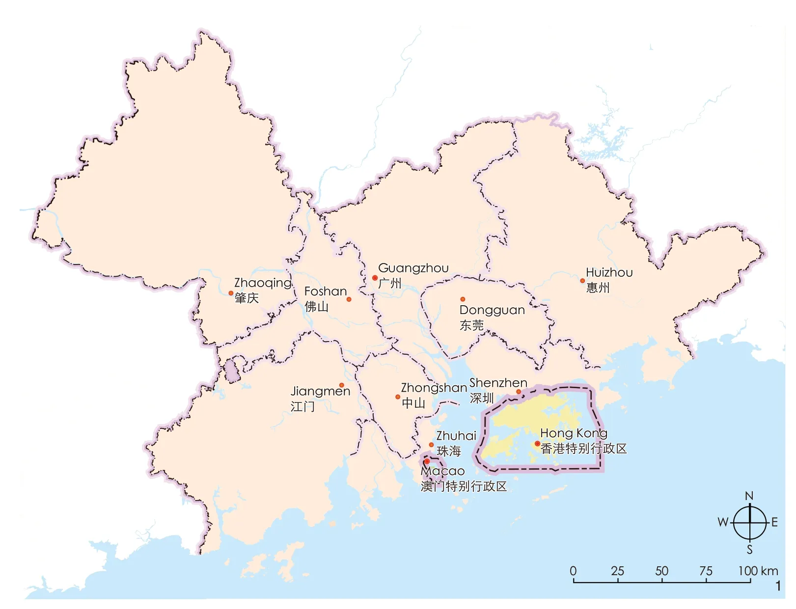
1 珠江三角洲城市群Pearl River Delta cities
珠三角是由广州、东莞、佛山、惠州、江门、深圳、肇庆、中山、珠海9个地级市和香港、澳门2个特别行政区组成的密集城市网络,总面积超过5.5万km2(表1)。
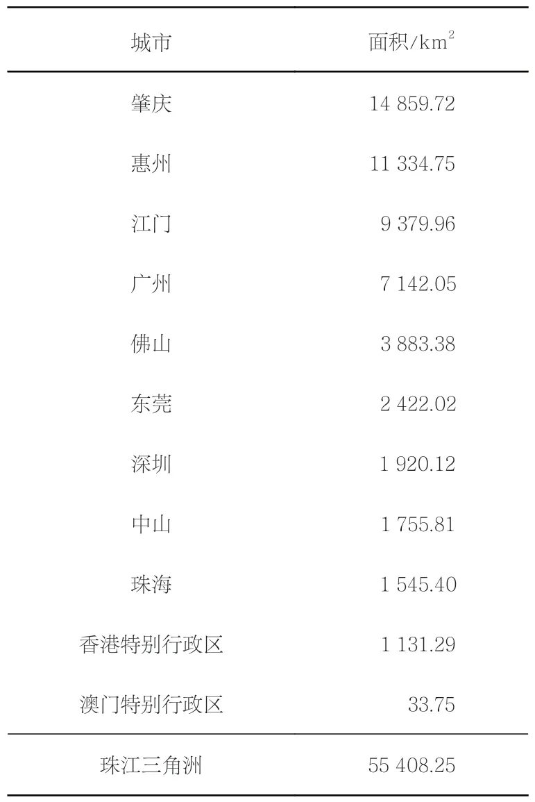
表1 珠江三角洲的城市(按面积排序)Tab.1 The cities of the Pearl River Delta (PRD), ranked by area
1979年改革开放后,珠江三角洲城市群迅速成为中国乃至世界最具经济活力的地区之一。在经济改革实施不到10年的时间里,珠江三角洲的GDP总量占全国的7.35%[18]。经济发展良好,2016年GDP总量占全国的9.1%[19]。
在经济增长的同时,该地区也经历了巨大的人口增长,在2014年超过东京成为世界上面积和人口最大的城市圈[20],在2016年人口已近7 200万。
经济快速发展与空间结构的剧烈转变同时发生,工业生产大幅增加,农业生产份额急剧下降,直到如今城市化进程才开始放缓。
快速城市化、高强度的人类活动以及气候变化带来的影响,正在破坏珠三角地区的微妙平衡,威胁着其可持续发展,使其面临多重挑战。
一方面,洪水多发地带的城市化问题、海平面上升以及极端台风和风暴导致珠三角地区面临的洪水风险越来越大。另一方面,灰色基础设施的无序扩张会导致自然系统的破碎化,以及随之而来的相关生态系统服务的崩塌[21]。农业和工业活动对水量和水质也有负面影响,分别占需水量的33%和37%,并造成地表水系统的污染。事实上,在2015年,珠三角39%的河水被认为是“不适合人类接触的”[22]。
珠三角的城市化进程在时间和空间上是不均衡的。1978年以农业发展为主的阶段结束后,珠三角的发展又经历了3个阶段[23]:工业化阶段(1978—2000年);城市化和大都市化阶段(2000—2008年);城市化背景下的农村快速转型阶段(2008年至今)。每个阶段的政策不同,这些政策随着时间推移对土地覆盖产生了不同的影响。此外,城市化最密集的地区主要分布在珠三角东岸的轴线上,从广州到香港,途经东莞和深圳。相反,珠三角西岸相对欠发达,除广佛都市圈外,其他城市区域均散布在洪泛区。
1.2 数据和软件
珠三角的土地覆盖演变分析使用了覆盖全球的开源数据集。使用开源数据主要基于2个原因:1)为了测试可用的免费土地覆盖数据在精细时间颗粒度上对区域尺度土地覆盖演变分析中的潜力;2)为这种方法在全球其他三角洲地区应用的普适性奠定基础。
因此,本研究使用了关于土地覆盖、海拔和行政单位的3个主要数据集(表2)。

表2 用于土地覆盖演变分析的源数据集Tab.2 Source datasets used in the analysis of land cover change
ESA CCI是在欧洲航天局气候变化倡议土地覆盖项目框架内提供的全球开放土地覆盖地图。这些地图覆盖全球,空间分辨率为300 m,1992—2015年地图每年更新一次。在光栅数据集中,每个像素值代表一个特定的土地覆盖类型(表3)。
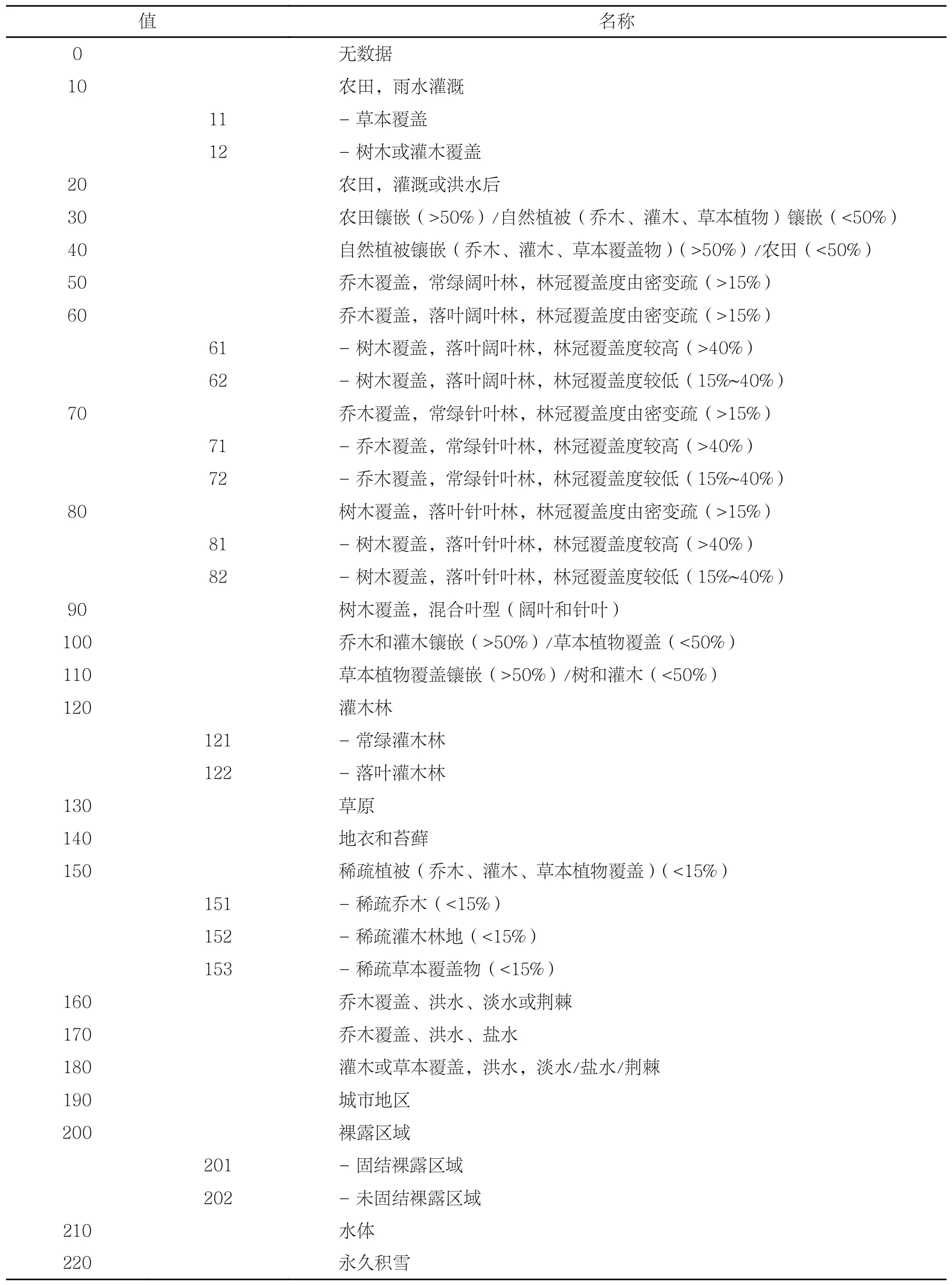
表3 欧洲航天局气候变化倡议土地覆盖类型Tab.3 ESA CCI Land Cover Classification
高程数据来自美国地质勘探局负责的航天雷达地形勘测任务。航天飞机雷达地形勘测任务是美国国家航空航天局和美国国家图像和测绘局的联合项目,旨在绘制高水平的地球陆地表面的三维地图。美国领土之外的可用数据包括3"数据,相当于90 m。本研究使用了地理参考标记图像文件(georeferenced tagged image files, GeoTIFFs)。
最后,使用行政区划边界③来裁剪光栅数据集。通过R Studio软件④对空间数据进行重新投影、预处理和细化。最终输出一个自动执行整个过程的脚本,该脚本之后会公开发表。
1.3 数据预处理
在开始分析之前,先将23张ESA CCI光栅图和高程光栅图裁剪到珠江三角洲地区的行政区划边界内。裁剪后每个土地覆盖地图都由632 213个单元格组成,原始分辨率为300 m。随后将这些单元转换为地理坐标,并与高程光栅图叠加,以确定其中哪些位于LECZ。为了确保其参考性,本研究将LECZ定义为海平面以上、海拔10 m以下的连续的沿海地区[24]。这些地区特别容易受到海平面上升、强风暴和气候变化引发的其他灾害的影响,因此与其他高地势地区相比更加脆弱。此外,这些地区的城市化是对沿海和三角洲生态系统的一种伤害,导致为城市住区提供保护功能的生态系统受到侵蚀,从而放大了与气候相关的风险。最后,将生成的点网格与行政边界图层进行空间叠加,以确定珠三角每个城市的LECZ包含多少单元(表4,图2),以及1992—2015年每年的土地覆盖类型和占比。

表4 不同城市海拔10 m以上/下的单元格数及占比Tab.4 Number and percentage of cells above or below 10 meters above sea level by city
从中可以清楚地看出:三角洲的西翼包含大量LECZ,尤其是中山市超过3/4的区域位于潜在的脆弱地区,其次是佛山市(67.70%)和珠海市(61.59%);在珠三角东部,东莞是LECZ占比最高的城市(44.13%)。
1.4 土地覆盖重新分类
裁剪土地覆盖地图后,对ESA CCI中的土地利用类型进行重新分类和汇总。重新分类是考虑到与水有关的农业和植被的广泛存在,例如整个三角洲地区的基塘系统。因此,确定了7个土地覆盖大类(表5):森林、农业(农田)、农业(灌溉)、森林(水)、草地、灌木林、稀疏植被、裸露地区、城市化地区和水。

表5 1992年和2015年用于分析的土地覆盖大类和各小类的单元格数量Tab.5 Proposed Aggregated Land Cover Classes for the analysis and number of cells for each class in 1992 and 2015
1.5 时空矩阵
最后一步是在R Studio中开发程序来创建时空矩阵。在矩阵中,每一行对应一个点,该点信息包括坐标(经度和纬度)、海拔(在重新分类中为海拔10 m以上/下)、城市、编码1~7对应的土地覆盖大类(表5)。最终时空矩阵包括坐标(显示为x和y)、城市、海拔以及每年土地覆盖值的信息,即 1992—2015 年按年份划分的土地覆盖类型(表6)。
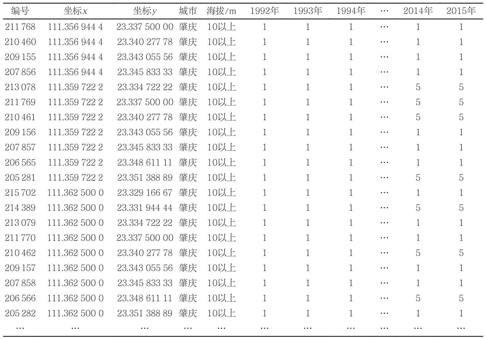
表6 时空矩阵样本Tab.6 Sample of the final spatio-temporal matrix
时空矩阵是土地覆盖演变模式分析的起点。矩阵的相关数值是生成分析的关键。纵向数据展示了按年份划分的每一类土地覆盖类型,可按城市和海拔进行分组。横向数据可以逐年逐点对照土地覆盖演变的强度和差异,或按城市、海拔高度汇总。
此外,这种结构可以很容易地确定每个城市LECZ内外最容易发生变化的土地覆盖类型。下面将介绍其中一些分析结果。
2 分析结果
对比1992年和2015年的土地利用地图,发现23年间整个珠三角地区的城市面积增加了3.5倍以上,从约2 050 km2增加到约6 380 km2(图3)。而农业地区(-3.71%)和其他地区(包括灌木林、草原和裸露地区,-2.97%)的土地覆盖率有所下降。灌溉农业面积也大幅减少,从11 252.91 km2减少到10 508.95 km2(-1.34%)。其他土地利用类型基本保持不变。水域面积减少(尽管幅度不大)可能表明,随着时间推移一些水域已被填埋造陆。
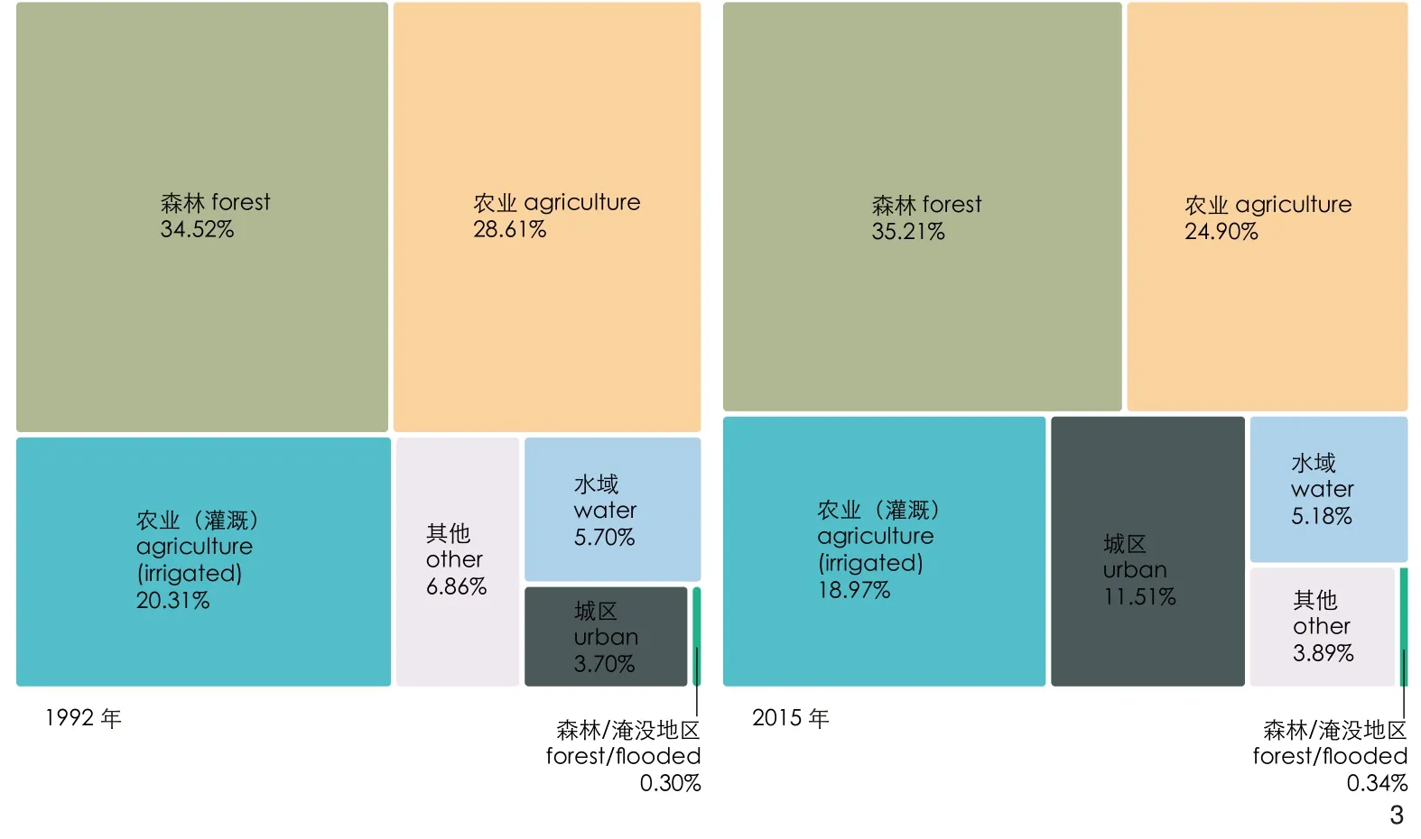
3 珠江三角洲土地覆盖总体变化(1992—2015年)Total land cover change in the PRD (years 1992-2015)
除了定量方面之外,土地覆盖图(图4)清楚地显示了该地区城市化的空间格局。对比1992年和2015年的2幅图,可以看出珠三角的城市化进程并不均衡,且可以确定3个主要演变趋势。1)随着时间推移,沿入海口东岸和广港航线地区的建成区与海岸线相接,形成LECZ。东莞和深圳经历了名副其实的爆炸式城市化发展,只是受其领土地形的限制。2)西部轴线从广州延伸到澳门,广州和佛山相互融合,城区总体上发展更加集中。3)在三角洲地区更为边缘的地带,城市化主要发生在更集中的城市中心和发展主轴的沿线。
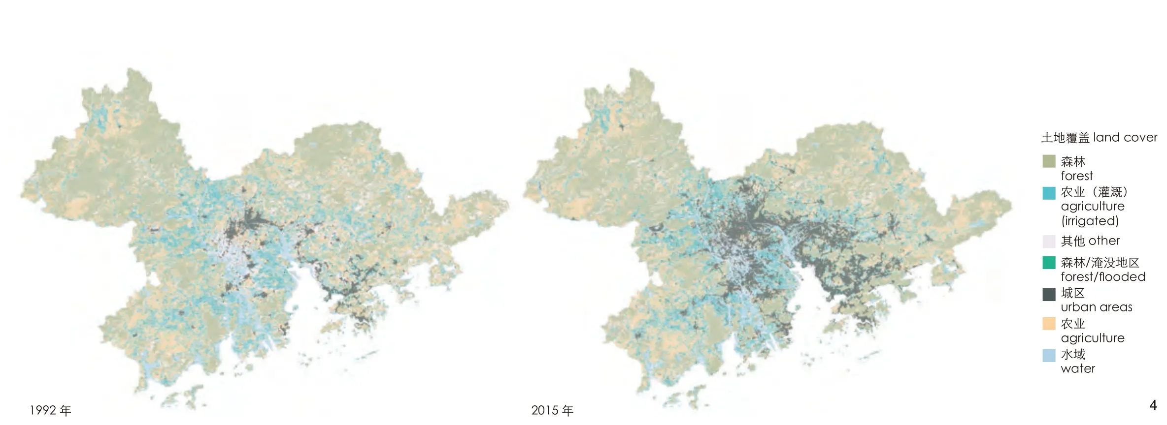
4 基于ESA CCI的珠江三角洲土地覆盖地图(1992—2015年)Land cover maps of the PRD, based on ESA CCI (years 1992-2015)
接下来对多年来土地覆盖演变的程度和地点进行分析。在图5中,蓝色条表示LECZ的变化,深灰色条表示海拔10 m以上区域的变化。包含所有土地覆盖类型的土地覆盖演变强度在空间上并不均匀。事实上,这种空间分布不均主要发生在LECZ,在三角洲内有2个明显不同的趋势。1)从空间维度来看,深圳和东莞是中国农用地转变为城市建成区最显著的城市,2001年和2002年分别达到16.6%和16.5%的峰值;位于珠三角中心地区的其他沿海城市紧随其后;江门和肇庆排在后面。2)从时间维度来看,1995年是珠三角所有城市土地覆盖演变首次均匀增加的一年。2001—2002年是演变增幅最大的时期,尤其是在深圳和东莞。然而,从2005年开始可以观察到下降的趋势,尤其是在发展更成熟的城市。
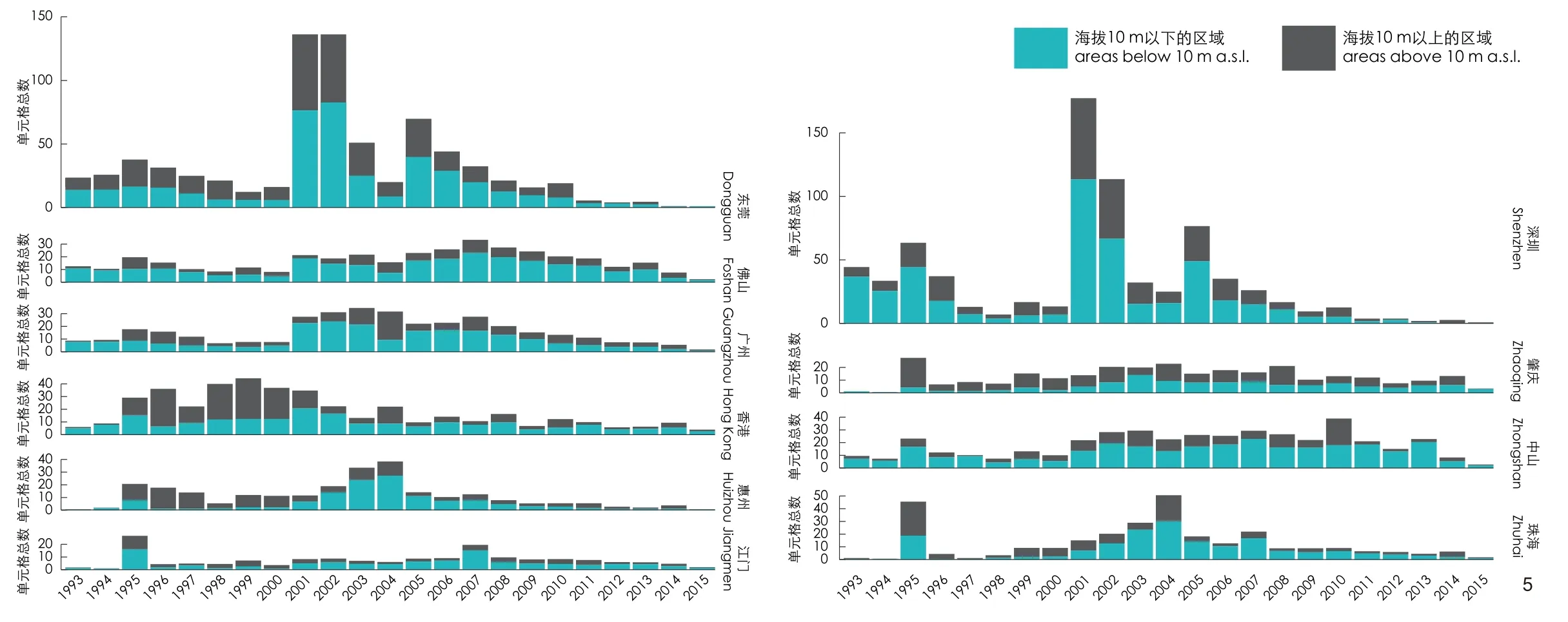
5 各城市低海拔海岸带的土地覆盖逐年变化Land Cover Change in LECZ by year, per municipality
3 讨论
对1992—2015年珠江三角洲土地覆盖演变的分析结果表明,存在2个变化速度和强度明显不同的区域:一个是位于珠三角核心区的沿海城市;另一个是珠三角外围的城市,如江门和惠州。特别是在经济改革实施初期,位于入海口东侧的深圳和东莞土地覆盖演变速度较快。从图5可以清楚地看到,这2个城市的土地覆盖演变先行发生,而且强度较大,这主要是由城市化和农村向工业区转型而推动的。其他在历史上占重要地位的城市如广州、香港,其土地覆盖演变强度较低也更稳定。
总的来说,土地覆盖演变的强度在很大程度上取决于发生在三角洲这一地区的城市化进程。这主要是由于深圳被划定为经济特区,特别是在经济改革实施后的前几十年里,极大地促进了城市化。
珠海经济特区的情况似乎有所不同。数据分析表明,在20世纪90年代初,土地覆盖几乎没有变化,只在1995年达到峰值。这一趋势在20世纪90年代末发生了变化,在2004年达到峰值,然后再次下降。在位于珠三角西轴的城市中,佛山和中山的土地利用发生了最显著的变化。相反,珠江三角洲边缘城市的土地覆盖演变速度较慢。
通过比较各个发展阶段中不同城市的变化趋势,可以得出2个结论。
1)如上所述,有一些城市在各个阶段率先转型,还有一些城市紧随其后。深圳和东莞是在三角洲工业化阶段以及城市化和大都市化阶段土地覆盖演变迅速的城市。同样,从2008年开始,这两座城市的土地覆盖演变速度放缓,届时珠三角进入对已城市化地区的再开发阶段,并更加重视环境保护,这点在发展更成熟的城市中尤为突出。这一趋势与珠江三角洲的西部地区略有不同,那里的土地覆盖演变大体保持不变,尤其是在LECZ,以中山市尤为突出。
2)与其他地区相比,LECZ的土地覆盖演变强度更高,同时也更脆弱。城市化的快速进程导致人口、重要基础设施、服务和经济资产的问题迅速暴露。
我们需要在珠江三角洲的不同地区采取有针对性的措施,以遏制土地覆盖演变的趋势,从而减少与气候相关的风险。在土地消耗减缓、致力于更新城市化地区的城市,应优先考虑实施适应建筑环境的干预措施。
这意味着要恢复沿海红树林等关键生态系统空间,特别是在入海口东岸,恢复其作为抵御猛烈风暴潮和洪水的自然屏障的能力。此外,在正在重建的地区,应尽可能多地推广基于自然的解决方案(nature-based solutions),以更好地管理地表径流并改善水质。还应系统地提高城市地区的土壤渗透能力,并进行植被重建,以恢复洪泛区管理地表径流的自然能力并改善其质量。
在入海口西岸应采用不同的策略。例如中山,或更小尺度的江门和珠海,仍然受到相对较大的土地覆盖演变的影响,我们首先需要明确城市化如何导致土地覆盖演变。我们应采取控制城市扩张的政策,以避免西江沿岸具有重要文化和生产价值的农业水产养殖景观进一步破碎化。
4 结论
图析三角洲地区土地覆盖随时间的变化图,可以揭示其演变的主要模式,辅助识别稳定性特征,并保护维持其韧性的要素。本研究提出了一种基于ESA CCI土地覆盖图、使用时空矩阵来量化珠三角城市的土地覆盖演变模式的方法。该数据集涵盖了1992—2015年的年度数据。这种精细的时间颗粒度能够以非常高的精度界定土地覆盖演变规律,从而更容易识别城市区域内经济政策随时间的空间溢出效应。
围绕该数据集构建的时空矩阵,有助于了解土地覆盖演变趋势如何在像珠江三角洲这样有活力的地区分布,从而比较整个地区随时间变化的土地覆盖演变强度的不同。
使用这种全球开源数据集的优势有2个:一方面,它以精细时间颗粒度为单位提供系统化的信息,使定量研究空间演进模式成为可能,比如变化发生在何时何地,什么类型的土地覆盖受影响最大,以及变化的主要驱动因素是什么;另一方面,这些数据在全球范围内可用,这意味着研究者可比较世界各地不同三角洲地区的土地覆盖演变情况,而且在那些国家或地区层面的信息不存在或不可用的地区,这些数据依然适用。
当然,此数据集也有一定局限性。比如,当涉及区域层面的分析时,这个数据集被证明是非常充分的。即使是在城市区域内,300 m的空间分辨率也足以分析土地覆盖演变趋势。然而,当缩小规模或分析更紧凑的地区时,例如澳门,这些数据可能失去其空间意义。因此,澳门不在本研究范围内,因为土地覆盖数据缺乏一致性。
该数据集的另一个局限是,虽然它对森林和农业地区的分类足够全面,但对建成区却不能这样分析。这说明,在分析建成环境密度变化方面,此数据集并不具备显著性。然而,这个问题可以通过交叉使用其他来源的数据来克服,例如通过遥感图像的监督分类等方法。特别是在珠三角地区,几十年来的城市化进程一直是由农业地区的工业化推动的,农业也是转型政策的主要目标之一,因此有必要对相关程度最高的工业地区进行分类,以使其在区域规模上与城市地区区分开。
本研究在时间维度上,通过量化区域尺度土地覆盖演变来评估并解读珠江三角洲的转型。未来可在3个方面展开进一步研究。1)将这种定量分析与着眼于土地覆盖空间组构的相关分析相结合。这类分析考量了景观空间,包括但不限于通过景观生态学领域的指标来测度。在珠三角的研究背景下,意味着要了解珠三角各城市之间的空间组构关系,不同景观类型是如何破碎的,以及三角洲不同城市是如何发展的。2)可将这类分析与生态系统服务分析相结合,来衡量后者随时间推移的变化及受到人类活动的影响。3)开发预测模型,利用时空土地覆盖演变图预测未来的变化和土地利用政策的影响。
注释:
① 本文中的珠江三角洲是指大珠江三角洲,包括珠三角和香港、澳门2个特别行政区。
② www.esa-landcover-cci.org。
③ 采用全球行政区域数据库的行政边界(gadm.org/download_v4.html),该数据库为学术和非商业用途提供免费可用的空间数据。
④ R Studio是一款免费的数据科学开源软件(www.rstudio.com)。它使用了R语言——一种用于统计计算的编程语言。
图表来源:
文中图表均由作者使用表2中的地理空间数据绘制,图1审图号GS(2019)4342号。
(编辑 / 王一兰)
著者简介:
(意)丹尼艾勒·坎纳特拉 / 男 / 博士 / 代尔夫特理工大学建筑与建成环境学院助理教授 / 研究方向为复杂适应系统理论、区域设计、气候变化应对战略
译者简介:
李佳琪 / 女 / 哈尔滨工业大学(深圳)建筑学院在读硕士研究生 / 研究方向为图析与城市设计
校者简介:
蔡佳秀 / 女 / 博士 / 香港中文大学建筑学院助理教授 / 本刊特约编辑 / 研究方向为城市设计理论与方法、城市形态学、建筑模式语言、设计思维与设计过程
CANNATELLA D.Mapping Land Cover Change Through the Implementation of a Spatio-Temporal Matrix: The Case of the Pearl River Delta (China)[J].Landscape Architecture, 2023, 30(11): 70-86.DOI: 10.12409/j.fjyl.202208170491.
Mapping Land Cover Change Through the Implementation of a Spatio-Temporal Matrix: The Case of the Pearl River Delta (China)
Author:(ITA) Daniele Cannatella Translator: LI Jiaqi Proofreader: CAI Jiaxiu
Abstract:[Objective] In rapidly urbanizing deltas, the impacts of climate change and land cover transformation are highly interconnected.Therefore, mapping land cover change (LCC) over time is a relevant research objective to investigate both the impacts of human activities on these urban systems and to assess their degree of vulnerability to natural disasters.[Methods] This paper presents a systematic analysis of LCC patterns in the Pearl River Delta (PRD) in both space and time to shed light on spatial impacts of land-use policies on this deltaic megaregion and map out recommendations for responses to climate change mitigation and sustainable urban development.[Results] This paper presents a methodology for mapping LCC at the regional scale over time using R Studio and entirely based on open data, through the implementation of a spatiotemporal matrix.It uses ESA CCI land cover maps and USGS elevation maps to analyze patterns of change in the PRD, one of the fastest urbanizing regions in the world, over years 1992-2015.Through the quantification of LCC patterns at a fine temporal grain, the study reveals how the stages of development in PRD correspond to different trends in the intensity of change in different areas of the delta.In addition, LCC rates are higher in the low elevation coastal zone (LECZ), particularly prone to sea-level rise, stronger storms and other hazards induced by climate change.[Conclusion] The proposed matrix can help decision makers to better understand the spatial and temporal variation of LCC across deltaic regions, that can aid in the formulation of targeted planning strategies to increase resilience in vulnerable coastal areas.
Keywords:land cover change; open-source data; mapping; deltaic regions;Pearl River Delta; ESA CCI land cover maps; R
©BeijingLandscape ArchitectureJournal Periodical Office Co., Ltd.Published byLandscape ArchitectureJournal.This is an open access article under the CC BY-NC-ND license.
In fast urbanising areas, understanding the implication of change in land cover and land use is a crucial task to assess the impact of spatial policies, respond to risks posed by natural disasters,deal with the negative impacts of climate change and develop strategies aiming for sustainable urban development.This is especially relevant for regions where growing urbanisation and the new climate regime have a greater impact, and therefore coherent, informed and systemic adaptation and mitigation actions are needed, as in the case of urban deltas.Climate change and land cover are connoted by a deep and mutual relationship, in which one affects the other.The impacts of land use/land cover change (LULC) on global climate reveal themselves in the flux of CO2in the atmosphere, whereas climate change affects land use and land management strategies, and calls for mitigation and adaptation responses to tackle the negative effects of climate change[1].Furthermore,land cover change and related use are one of the main drivers of global change, altering land and water resources availability, ecosystem services, and hydrological processes[2].Land erosion as a consequence of human activities can have major impacts on the integrity and quality of vital natural resources, such as water and soil.Urbanisation and anthropogenic action can alter the distribution of ecosystems and their associated fluxes of energy and matter, affecting their capacity to support and sustain humans and other living beings.Land use practices, in conjunction with climate change, play a key role in determining the quality of the hydrological performance of watersheds[3].In deltaic areas, urbanisation in flood-prone areas increases the exposure of human lives and assets to natural disasters, and the resulting uncontrolled increase of impervious surfaces affects the capacity of floodplains to attenuate water infiltration into soils[4], while simultaneously redirecting water runoff and magnifying peak discharges.Fundamental processes such as evapotranspiration,groundwater flow and stream discharge regime are also affected by land use[5], influencing the correct functioning of the water cycle in urban areas.These alterations generate direct consequences on the vulnerability of urban systems to floods[6],landslides, storms and droughts among others, as the engineered infrastructure for water management is not designed to deal with the growing stress caused by the altered patterns of precipitation.Changes in land use have negative impacts on water quantity and quality.The expansions of crop areas requiring high inputs of nutrients can lead to higher sediments, nitrates and phosphorus loads in surface waters[7-8].Agricultural expansion, together with industrial activities and urbanisation, will further deplete groundwater supplies, leading to growing imbalances between water supply and demand[9].
Mapping the change in land cover over time is therefore a key activity to investigate the implications of the evolution of urban systems both from a spatial and a quantitative point of view.Mapping as a method is a powerful tool for carrying out a systematic study of deltaic landscapes undergoing urbanisation[10].In particular, using spatial analysis methods and tools based on geographic information systems (GIS)can support the quantification of certain aspects regarding the composition and the configuration of the urban landscape through the development or use of metrics that refer to land cover maps.Comparing the evolution of urban landscape patterns within a region can help to provide more insightful information on the similarities and dissimilarities of processes of spatial transformation from a temporal perspective.Moreover, it assists in analysing the impact of land use policies on the territory over time, and consequently formulate planning choices aimed at sustainable urban development.
To carry out this type of analysis, it is possible to make use of numerous LULC products that are produced at different scales, from global to national, and different spatial resolution.LULC is a significant resource based on remote sensing that provides information on global and regional vegetation cover, and is widely used in various largescale climatic, ecological, and hydrological models[11].
This research makes use of the Pearl River Delta (PRD)①, the fastest urbanizing deltaic region in the world, as a case study.Several studies with different purposes have been conducted to analyse LULC in the PRD.For example, Seto et al.[12]estimated land-use change over time for a part of the PRD incorporating the estimates in a socioeconomic analysis of the factors influencing such change using Landsat TM imagery.Some scholars focused on the prediction of future land-use in the region[13], incorporating planning policies into a land-use simulation model[14]or identifying the contribution of different LULC driving factors[15].Other studies focus on the quantification of LULC impacts on ecosystem services[16-17].These analyses focus mainly on the PRD region as a whole, and are characterised by timeframe ranging from three years to ten years.Furthermore, they overlook the diversity of intensity and variation of transformation in different parts of this megaregion.
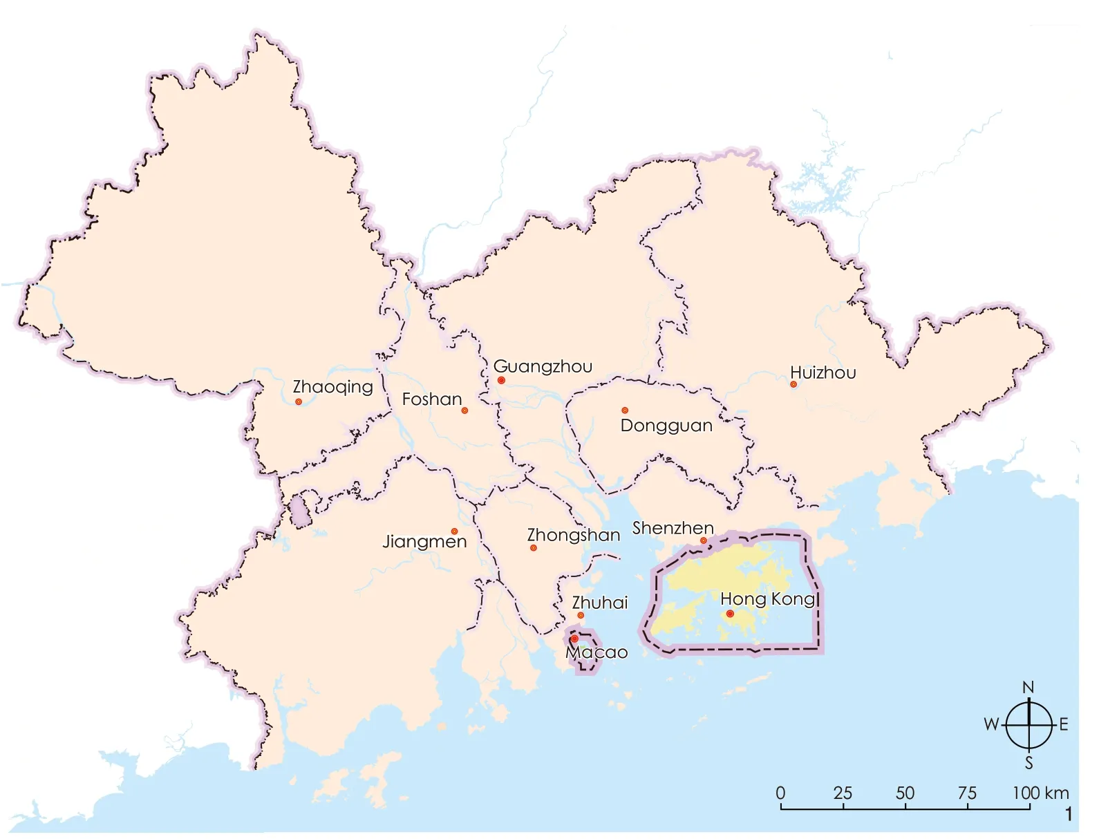
1 Pearl River Delta cities
The aim of this paper is twofold.On the one hand, it investigates the different spatial and temporal patterns of land cover change (LCC)across PRD’s cities at a fine temporal grain (1 year)to understand the spatial impacts of land-use policies on the region.On the other hand, it proposes a methodology for the spatio-temporal mapping of land cover change at the regional scale based entirely on open-source data.It utilises ESA CCI (European Space Agency Land Cover Climate Change Initiative Project)②land cover maps and USGS elevation maps as base data, to define the intensity of annual land cover variation in the low elevation coastal zone (LECZ), comparing it with the rest of the region.The LECZ is used as a proxy to identify vulnerable areas, particularly prone to inundation from sea level rise, storm surge, wetland degradation, land subsidence and flooding.The ESA CCI dataset covers the period 1992-2015 with maps produced on a yearly base.
1 Materials and Methods
1.1 The Pearl River Delta
The Pearl River Delta is located in the south-eastern part of China (Fig.1).From a geomorphological perspective, the PRD is an alluvial plain formed by three main tributaries, the Xi Jiang (West River), Bei Jiang (North River), and Dong Jiang (East River).The three rivers converge in the central part of the delta before flowing into the South China Sea.
The PRD is home to a thick network of cities formed by nine prefectures located on the mainland — namely, Guangzhou, Dongguan,Foshan, Huizhou, Jiangmen, Shenzhen, Zhaoqing,Zhongshan, and Zhuhai — and the two Special Administrative Regions of Hong Kong and Macao.Altogether, the nine prefectures and the two Special Administrative Regions cover a total area of over 55 thousand square kilometres (Tab.1).
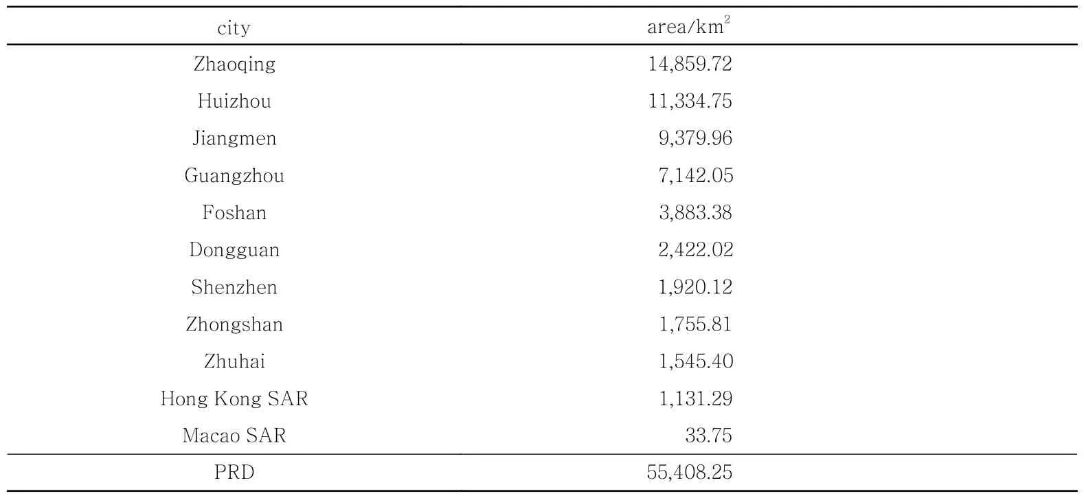
Tab.1 The cities of the Pearl River Delta (PRD), ranked by area
After the launch of the open door policy in 1979, the PRD rapidly became one of the most economically dynamic regions in China and the world.In less than ten years since the implementation of the economic reforms, the PRD’s total GDP accounted for 7.35% of the country’s total[18].This trend has never suffered any major setbacks, reaching 9.1% of China in 2016[19].
Concurrently with this economic growth, the region has experienced tremendous demographicgrowth, surpassing Tokyo to be the world’s largest urban area in both size and population in 2014[20],and reaching a population of nearly 72 million inhabitants in 2016.
This abrupt economic development coincided with a dramatic structural and spatial transformation that saw a large increase in industrial production and a simultaneous drastic decline in the share of agricultural production, but also a process of urbanisation that only today seems to be slowing down.
Relentless urbanisation and uncontrolled anthropogenic activities, together with the impacts generated by climate change, have been undermining the delicate balance of this deltaic region, threatening its sustainable development and confronting it with multiple challenges.
On the one hand, the region is exposed to growing flood risks, due to urbanisation in floodprone areas, rising sea levels, and extreme typhoons and storms.On the other hand, increasing soil sealing contributes to the fragmentation of natural systems and the subsequent erosion of related ecosystem services[21].Agriculture and industry also have a negative influence on water quantity and quality, representing respectively 33% and 37% of water demand and contributing to the pollution of the surface water system.In fact, in 2015, 39% of its river waters were considered “unfit for human touch”[22].
The urbanisation process in the PRD has been uneven in space and time.After a phase characterised mainly by agricultural development,which ended in 1978, the development of the PRD went through three further stages[23]: the industrialisation stage (1978-2000); the urbanisation and metropolitanism stage(2000-2008); and the rapid rural transformation under urbanisation stage (2008-present).Each of these stages is characterised by different policies which in turn have had equally different impacts on land cover over time.In addition, the most intense urbanisation has occurred mainly along the eastern axis of the delta, which runs from Guangzhou to Shenzhen, and continues to Hong Kong, and through Dongguan and Shenzhen.Conversely, the western axis is relatively less developed, with a metropolitan cluster consisting of the conurbation of Guanzhou and Foshan, and more compact urban areas dotting the floodplain.
1.2 Data and Software
The LCC analysis of the PRD was carried out using open-source datasets with global coverage.The choice of employing open-source data is due to two main reasons.Firstly, to test the potential of available free datasets on land cover having a finegrained temporal resolution in LCC analysis at the regional scale.Secondly, to set the basis for its replicability in other deltaic regions around the globe.
For this reason, three main datasets on land cover, elevation, and administrative units were used(Tab.2).

Tab.2 Source datasets used in the analysis of land cover change
The ESA CCI Land Cover Maps are openaccess Global Land Cover maps provided within the framework of the European Space Agency(ESA) Land Cover Climate Change Initiative Project.The maps have global coverage and are available at 300 m spatial resolution.In addition,they are produced on a yearly base, covering the years from 1992 to 2015.In the raster dataset, each pixel value represents a specific land cover class(Tab.3).
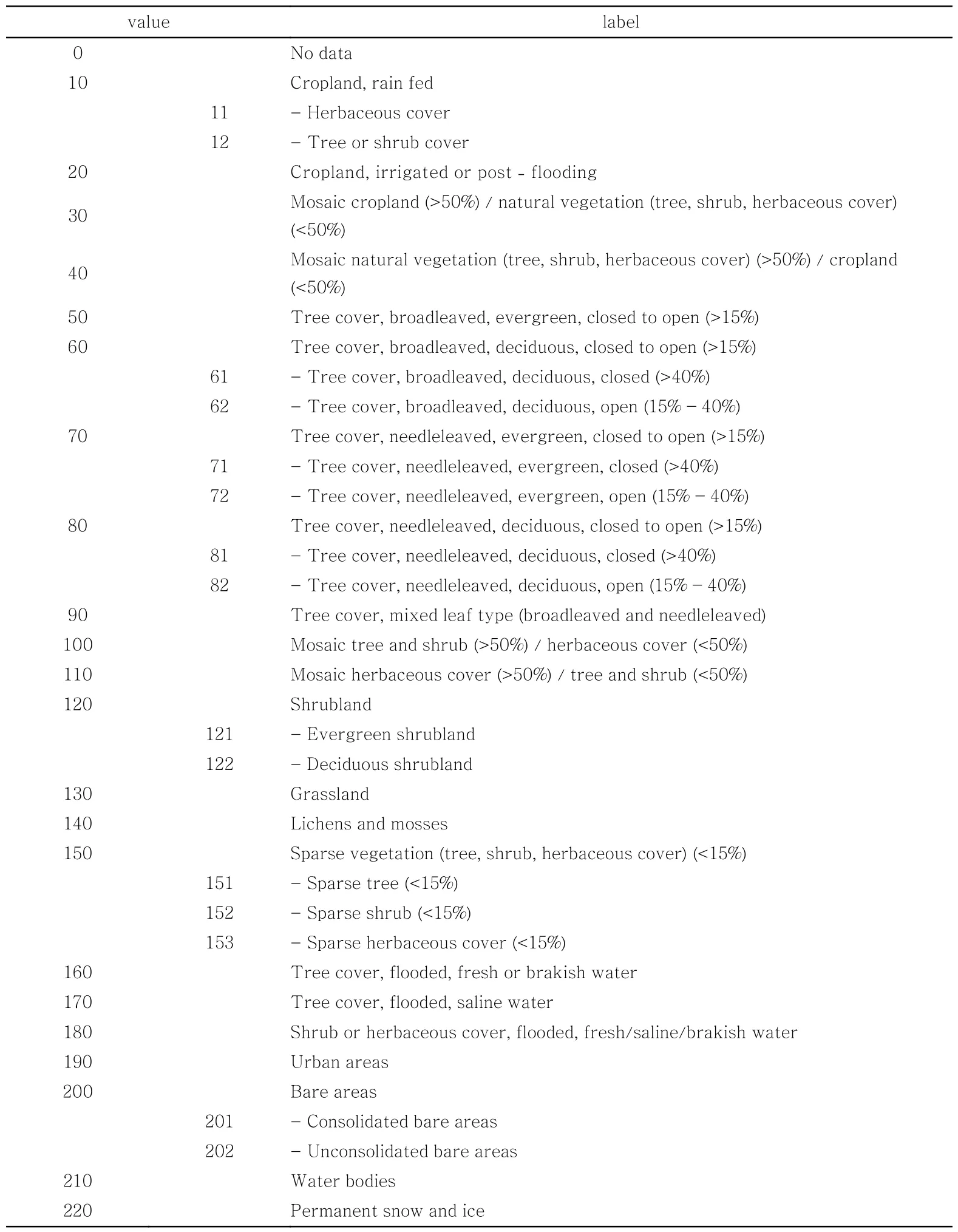
Tab.3 ESA CCI Land Cover Classification
Data on elevation was derived from the USGS SRTM (Shuttle Radar Topography Mission).The SRTM is a joint project between NASA and NIMA aiming at mapping the planet’s land surface in three dimensions at a high level of detail.Data available over non-U.S.territory include 3-arcsecond data, corresponding to approximately 90 m.For this analysis, georeferenced tagged image files(GeoTIFFs) were used.
Lastly, administrative boundaries③were used to clip the raster datasets.Spatial data were reprojected, preprocessed, and elaborated through R Studio software④.The final output is a script that automates the entire process, which will later be made publicly available.
1.3 Data Preprocessing
Before starting the analysis, it was necessary to clip the 23 ESA CCI raster maps and the elevation raster map to the administrative limits of the PRD.Each of the resulting land cover maps iscomposed of a total of 632,213 cells, having the original resolution of 300 m.The cells were subsequently converted into georeferenced points and cross-referenced with the elevation raster to determine which of them were located in the LECZ.For the sake of reproducibility of this study in other contexts, The LECZ is defined in this study as the contiguous areas along the coast that is less than 10 metres above sea level[24].These areas are particularly prone to sea-level rise, stronger storms and other hazards induced by climate change, and therefore more vulnerable than other areas lying on higher ground.Furthermore,urbanisation in these areas represents a treat to coastal and deltaic ecosystems, contributing to the erosion of ecosystem services delivering protection functions for urban settlements, thus amplifying climate-related risk.Lastly, the next step was the spatial intersection of the resulting point grid with the municipal boundaries layer.This made it possible to determine how many cells were located in the LECZ for each city in the PRD (Tab.4, Fig.2), and what type and share of land cover characterised them year by year, from 1992 to 2015.

Tab.4 Number and percentage of cells above or below 10 meters above sea level by city
From the map, it is clear that the western wing of the delta is characterized by a large presence of LECZ.In particular, more than threequarters of the territory of Zhongshan is located in potentially vulnerable areas, followed by Foshan(67.70%) and Zhuhai (61.59%).On the eastern side of the PRD, Dongguan is the city with the highest percentage of territory in the LECZ (44.13%).
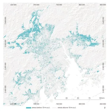
2 Map of areas in the LECZ
1.4 Land Cover Reclassification
After land cover maps were clipped, the next step entailed the reclassification and aggregation of land use classes proposed by the ESA CCI.The reclassification was made keeping in mind the widespread presence of water-related agriculture and vegetation, such as the dyke-pond system that characterises the whole deltaic region.For this reason, seven aggregate land cover classes were identified (Tab.5).These classes are: forest;agriculture (cropland); agriculture (irrigated); forest(water); grassland, shrubland, sparse vegetation and bare areas; urbanized areas; and water.

Tab.5 Proposed Aggregated Land Cover Classes for the analysis and number of cells for each class in 1992 and 2015
1.5 Spatio-Temporal Matrix
The final step involved the creation of a spatio-temporal matrix by developing a script in R Studio environment.In the matrix, each row corresponds to a point marked by coordinates(longitude and latitude), elevation (reclassified as above/below 10 m above sea level), city, and finally, a series of numerical values from 1 to 7,corresponding to the land cover categories per as described in Tab.5.Tab.6 shows a sample of the final matrix, including information on coordinates(displayed asxandy), city, elevation, and land cover values per year.The latter represent the land cover categories by year, from 1992 to 2015.Tab.6 shows a sample of the matrix containing the first 20 rows.
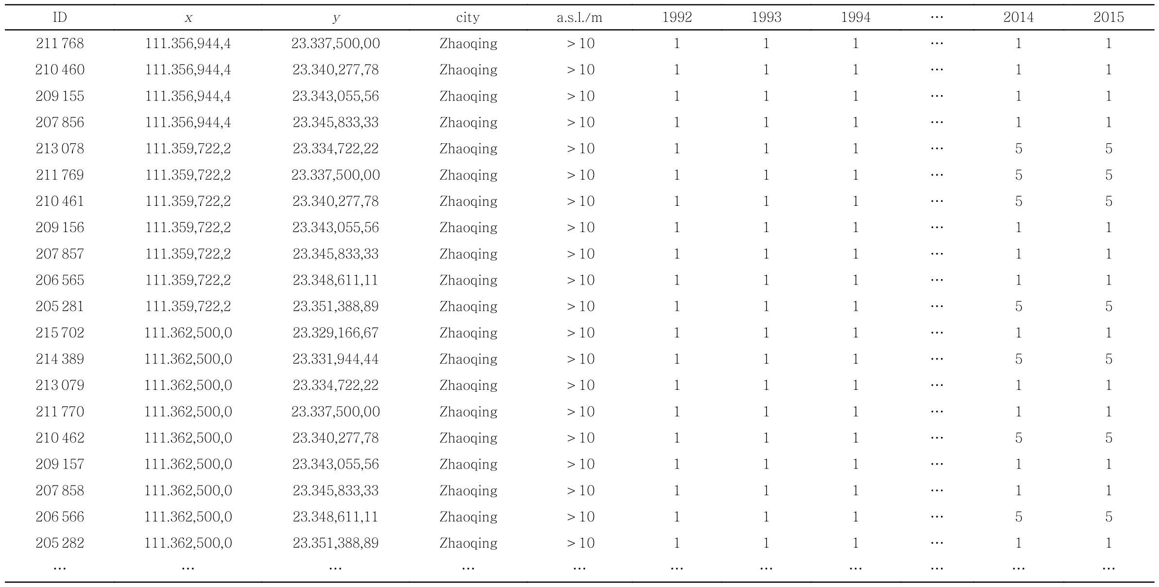
Tab.6 Sample of the final spatio-temporal matrix
The spatio-temporal matrix is the starting point for the land cover change pattern analysis.The relevant aspect of this matrix is that it yields several keys to interpretation.A “vertical” reading provides quantification of each aggregate class of land cover by year, groupable by city and elevation.A “horizontal” reading, on the other hand, returns the intensity and variability of land cover change year by year by point, or aggregated by city and/or elevation.
In addition, this structure makes it easy to identify the land cover categories most subject to transformation, inside or outside the LECZ, for each city.The next section presents the results of some of these analyses.
2 Results
Comparing land use maps from 1992 and 2015, we see that throughout the whole PRD region, in the span of twenty-three years, urban areas have increased more than three and half times, from about 2,050 km2to about 6,380 km2(Fig.3).On the other hand, a decrease in land cover is found in agricultural areas (-3.71%) and those classified as others (including shrublands,grasslands, and bare areas, -2.97%).Irrigated agricultural areas also decreased significantly, from11,252.91 km2to 10,508.95 km2(-1.34%).Other land use types remained essentially unchanged.The decrease in areas classified as water, however not substantial, may indicate that some areas have been reclaimed over time.
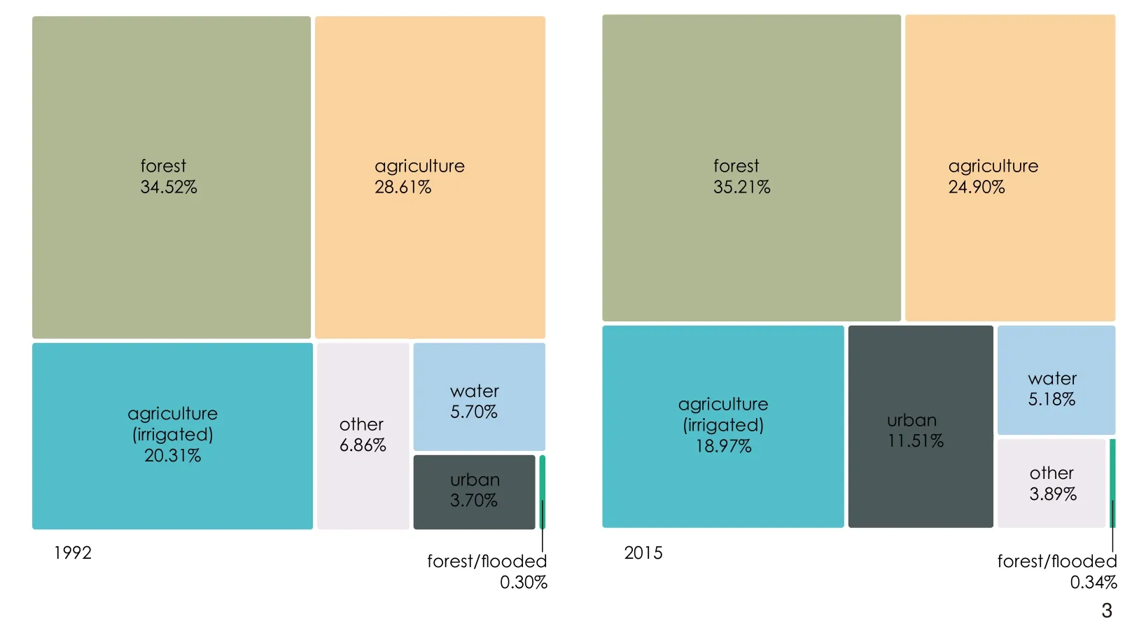
3 Total land cover change in the PRD (years 1992-2015)
Beyond the quantitative aspects, the land cover maps in Fig.4 clearly show the spatial patterns of urbanization in the region.A comparison of the two maps in 1992 and 2015 shows how urbanization in the PRD has not happened at all evenly.On the contrary, it is possible to identify three major trends.1) The first is along the east coast of the estuary, along the Guangzhou - Hong Kong route.In this area, builtup areas have welded together along the coast over time, thickening right into the LECZ belt.In addition, Dongguan and Shenzhen have witnessed a veritable explosion of urbanization, limited only by the topographical conformation of their territories.2) The western axis, running from Guangzhou to Macao, saw the merging of the cities of Guangzhou and Foshan and generally a more concentric development of urban settlements.3) In the more peripheral areas of the delta, urbanization took place mainly around the more consolidated urban centres, and along the main connecting axes.
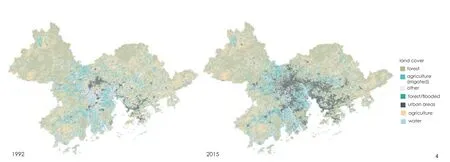
4 Land cover maps of the PRD, based on ESA CCI (years 1992-2015)
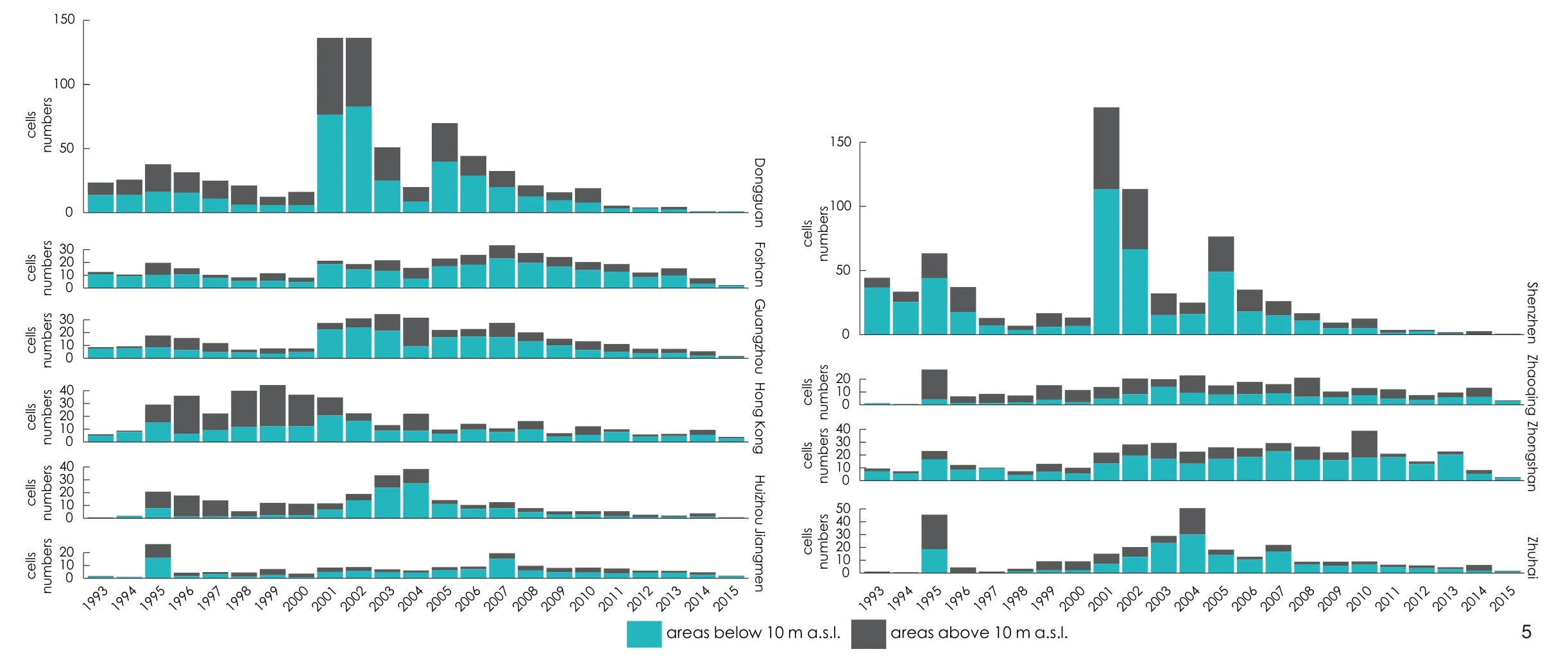
5 Land Cover Change in LECZ by year, per municipality
The second part of the analysis investigates how much and where land cover change has occurred over the years.In Fig.5, the blue bars indicate the change in the LECZs, and the dark grey bars express the change in the areas above 10 m a.s.l.The first thing that stands out is that the intensity of land cover change, which here takes into account all land cover categories, does not happen uniformly in space.In fact, it occurs mainly in the LECZ, and has two clearly distinct paces across the Delta.1) Looking at the temporal dimension, Shenzhen and Dongguan are the municipalities where the conversion of land to urban areas ihas occurred most significantly, with peaks of 16.6% in 2001 and 16.5% in 2002 respectively.Other cities along the coast follow,located in the central area of the delta.Jiangmen and Zhaoqing take the back seat.2) Looking at the temporal dimension, 1995 is the year in which the first increase in land cover change is recorded in all cities homogeneously.The 2001-2002 period is the one in which the largest increases in change are recorded, especially in Shenzhen and Dongguan.From 2005 onwards, however, a decline in transformation can be observed, especially in more mature cities.
3 Discussion
The results on the analyses conducted on land cover change in the PRD over the years 1992-2015 show the existence of two distinct geographies, each characterised by very different pace and intensity of transformation.The first is represented by the cities located in the PRD core area, along the coast; The second is the outermost cities, such as Jiangmen and Huizhou.In particular,Shenzhen and Dongguan, located on the eastern side of the estuary, are characterized by a high rate of land cover change, especially in the early stages of the implementation of economic reforms.When looking at Fig.5, it becomes clear that it is these two cities where land cover change occurs first and with greater intensity, driven primarily by urbanization and the transformation of the countryside into industrial areas.Other major and historically more important cities such as Guangzhou and Hong Kong have significantly lower, but also steadier, transformation intensities.
In general, the intensity of land cover change is largely determined by urbanization processes that mainly have been taking place in this part of the delta.This is mainly due to Shenzhen’s designation as a Special Economic Zone (SEZ), which has given an incredible boost to urbanization especially in the first decades since the implementation of economic reforms.
For Zhuhai’s SEZ, the situation seems to be different.Data analysis shows that in the early 1990s LCC was almost absent, except for a peak in 1995.This trend changes towards the end of the 1990s, with a steady increase culminating in a peak in 2004, before declining again.Of the cities located along the western axis of the delta, Foshan and Zhongshan are those whose territory has undergone the most significant transformation.The more peripheral cities in the PRD are the ones that have slower LCC rates instead.
When looking at temporal patterns, two relevant aspects emerge from comparing trends by city.
The first is that, as mentioned above, there are some cities that lead the transformation tendencies at various stages, and others that follow.Again, Shenzhen and Dongguan are the cities where it is possible to detect an acceleration in LCC in the industrialization stage of the delta, as well as in the urbanization and metropolitanism stage.Similarly, these are the first cities where there is a dramatic slowdown in LCC from 2008 onward,when the PRD enters a further phase characterized by the redevelopment of already urbanized areas and an increased focus on environmental protection, especially in more mature cities.This trend is slightly different for the western delta zone, particularly for Zhongshan, where the LCC still remains constant, especially in the LECZ.
Lastly, when comparing LCC intensity in LECZ and other areas, it is striking to see that it happened mostly in the former, which coincides with the most vulnerable areas.As urbanisation is the main driver of change, this resulted in a dramatic increase of exposure of people, critical infrastructure, services and economic assets.
This is clearly a trend that needs to be curbed to avoid increasing climate-related risk in the PRD by taking targeted action in its different parts.In cities where land consumption has slowed and efforts are devoted to regeneration of already urbanized areas, interventions dedicated to adapting the built environment should be prioritized.
This means identifying spatial opportunities to reinstate key ecosystems such as mangrove forests along the coasts, and restore their capacity to act as natural barriers against violent storm surges and floods, especially along the eastern side of the estuary.In addition, in areas undergoing redevelopment, nature-based solutions should be promoted more wherever possible to be able to better manage excess water and improve its quality.In addition, nature-based solutions should be promoted more in areas undergoing redevelopment, where possible.Systemic soil permeabilization and revegetation interventions in urban areas should also be encouraged, to restore the natural ability of floodplain to manage excess water and improve its quality.
A different logic should apply to the western side of the estuary.As Zhongshan, and to a lesser extent Jiangmen and Zhuhai, are still subject relatively high LCC trends, the question that needs to be asked is how this transformation should take place, especially with regard to urbanization.Policies to curb urban sprawl should be pursued to avoid further fragmentation of the agri-aquacultural landscape along the Xi Jiang, which is of great cultural as well as productive value.
4 Conclusions
Mapping deltaic regions’ land cover change over time can shed light on the main patterns that characterise their evolution, supporting the identification of those traits that resist modification as well as those that must be preserved to safeguard resilience.This paper proposed a methodology based on the use of ESA CCI land cover maps to quantify patterns of land cover change in the PRD cities through the use of a spatiotemporal matrix.This dataset covers the period from 1992 to 2015, on an annual basis.This fine temporal grain makes it possible to detect LCC rhythms at a very high level of accuracy,which in turn can more easily identify spatial spillovers over time of economic policies within an urban region.
Structuring the spatiotemporal matrix around this dataset also helps to understand how LCC trends are distributed in a region as dynamic as the PRD, making it possible to compare LCC intensities and temporal variations across the region.
The advantage of using such global open dataset is twofold: on the one hand, it allows to systematize information produced at a fine temporal grain to quantitatively investigate these patterns — where and when these changes occurred, what types of land cover are most affected, and what are the major drivers of change).On the other, this data is available at a global coverage, which means that it makes it easy to compare different deltaic regions across the world,but also that it can be used in areas where information at the national or local level is not present or not available.
This methodology has some limitations.When it comes to conducting a regional-level analysis, this dataset proves to be extremely adequate.A spatial resolution of 300 m is more than enough to analyze LCC trends even within an urban region.However, when scaling down or working on more limited areas, as in the case of Macao, these data may lose their spatial significance.For this reason, Macao was kept out in this study because there was little consistency in the LCC data.
Another limitation of this dataset is that while the classification it proposes on forest and agricultural areas is sufficiently broad, the same cannot be said for built-up areas.this implies that it is not significant when it comes to analysing the variation in density of the built environment.However, this problem can be overcome by crossreferencing it with other sources, for example by using methods such as supervised classification of remote sensing images.In the case of the PRD, in particular, where the urbanization process for decades has been driven by the industrialization of agricultural areas with the same being one of the main objects of transformation policy, a categorization becomes necessary to diversify the most relevant industrial areas from urban ones at the regional scale.
This study focuses on quantifying land cover change at the regional scale through a temporal assessment of the transformative dynamics that have occurred in the PRD.this type of study represents an essential preliminary analysis for subsequent analyses, which can be developed in three different directions.The first is the coupling of this quantitative analysis with an analysis that instead looks at aspects related to the spatial configuration of land cover.This type of analysis allows the exquisitely spatial aspects of the landscape to be taken into account, including by measuring them through metrics such as those belonging to the field of Landscape Ecology.Applied in the context of the PRD, this means understanding what kind of spatial configuration is emerging in the various cities of the PRD, how different landscape types are actually fragmenting,and how urban development is taking place in the different municipalities of the delta.The second aspect is the integration of this type of analysis with that on ecosystem services, to measure how the latter vary over time and are impacted by human activities.The third is related to the development of predictive models that make use of spatiotemporal land cover change maps to forecast future transformations and the impacts of land-use policies.
Notes:
① PRD in this paper refers to the Greater Pearl River Delta,which include PRD and the two Special Administrative Regions of Hong Kong and Macao.
② www.esa-landcover-cci.org.
③ Administrative boundaries from GADM (gadm.org/download_v4.html), which provides freely available spatial data for academic and non-commercial use, were employed.
④ R studio is a free and open-source software for data science (www.rstudio.com).It makes use of R, a programming language used for statistical computing.
Sources of Figures and Tables:
All maps and tables are made by the author, using the geospatial data mentioned in Tab.2, approval number of Fig.1 is No.GS(2019)4342.
(Editor / WANG Yilan)
Author:
(ITA) Daniele Cannatella, Ph.D., is an assistant professor at the Faculty of Architecture and the Built Environment, Delft University of Technology.His research focuses on complex adaptive systems theory, regional design, and adaptation strategies to climate change.
Translator:
LI Jiaqi is a master student in the School of Architecture,Harbin Institute of Technology, Shenzhen.Her research focuses on mapping and urban design.
Proofreader:
CAI Jiaxiu, Ph.D., is an assistant professor in the School of Architecture, The Chinese University of Hong Kong, and a contributing editor of this journal.Her research focuses on urban design theory and methods, urban morphology,pattern languages, and design thinking and design process.
