Improvement of reservoir quality of ultra-deep tight sandstones by tectonism and fluid: A case study of Keshen gas field in Tarim Basin,western China
2023-08-30JunpengWangHongyanWangRonghuZhangLiDongKeWangZhiyuanZhang
Junpeng Wang ,Hongyan Wang ,Ronghu Zhang ,Li Dong ,Ke Wang ,Zhiyuan Zhang
a China University of Petroleum,Beijing,China
b PetroChina Hangzhou Research Institute of Geology,Zhejiang,China
c Research Institute of Petroleum Exploration & Development,CNPC,Beijing,China
d Petroleum Exploration and Production Research Institute,SINOPEC,Beijing,China
Keywords:Reservoir quality Fluid interaction Tectonism Diagenesis Deep gas
ABSTRACT The Keshen gas field is one of the most important natural gas supply sources in the Tarim basin,western China.The main gas producing interval there is the Lower Cretaceous Bashijiqike Formation(K1bs),it is an ultra-deep tight reservoir whose buried depth exceeds 6000 m,and it shows a low matrix porosity(<10%) and extremely low matrix permeability (<0.1mD).However,this reservoir can supply extremely high and stable gas production due to improvement of reservoir quality by tectonism and fluid.Based on tectonic evolution analysis by plenty of lab data of core plugs or thin sections,the enhancement models of tectonism and fluid are built,evidence suggests both tectonism and fluid improve the reservoir quality greatly.Tectonic evolution produces lots of natural fractures in 3stages which promote the ultra-deep tight reservoir permeability 10-200 times,then,testing results of new boreholes without fracturing show reservoir permeability underground can reach 20 mD.Furthermore,fluid dissolution increases reservoir porosity 1-2 times,the main dissolved mineral is feldspar,all fluid dissolution came from the unconformity controlling the dissolution distance.Tectonism and fluid interact on each other: Tectonism controls fracture distribution and types of diagenic fluid in reservoir,but fluids influence fracture cements and dissolution.Both tectonic folding and the fluid flow control the sweet point reservoir located in upper 150 m formation.
1.Introduction
With the increasing demand for clean energy and the continuous progress of technology,ultra-deep natural gas reservoirs have become an important energy target.People in different countries and regions define the “deep reservoir” in different ways,Russia researchers suggest explorations deeper than 4000 m could be defined as“deep exploration”,otherwise,it could be 4500 m in the United States[1,2].In China,reservoirs,whose buried depth is more than 6000 m,is defined as “ultra-deep reservoir” [3,4].As an industry standard of“tight reservoir”,it shows matrix permeability as less than 0.1 × 10⁻³μm2[5].The deep tight sandstone gas in the foreland thrust belt of the Alberta Basin,Canada,is the earliest studied deep-basin gas in the world [6,7],by contrast,the Lower Cretaceous Bashijiqike Formation(K1bs),whose buried depth exceeds 6000 m and has a low matrix porosity(<10%)and low matrix permeability(<0.1×10⁻³μm2),is the main gas producing interval in Keshen gas field of Tarim Basin,so K1bs is ultra-deep tight reservoir.
Tectonization plays an important role in reservoir evolution,leading to natural fractures and faults which could be highways for fluids and hydrocarbon accumulations [8-10].Moreover,tectonization can lead to deformation bands or shear-enhanced compaction bands which play an important role in fluid migration[11,12].To demonstrate tectonic control to reservoir development,many researchers have acquired lots of evidences about fractures and diagenetic [13-15].Regional tectonic movements could produce different structural anticline which are traps for hydrocarbon accumulation,then different fracture types are developed in the fault related folds [16-20].Moreover,many scholars have been trying to find distribution patterns of fractures in different tectonic settings through various numerical modeling methods [21-25].However,fluids lead to different diagenesis in reservoir during the whole tectonic evolution,such as cementation,dissolution replacement and mineral precipitation.Researchers have made a common sense to diagenesis role in reservoir,cements or mineral precipitation usually be a barrier to fluid flow[26],but dissolution can make an enhancement of reservoir porosity [27-29].More significantly,however,more and more evidences have been found that cementation or dissolution change the rock mechanical property which could influence tectonic evolution [9,30],fracture cement bridges can keep fractures open [26,30],dissolution could make more reservoir space but also change rock properties[31].In a word,fluids are interacted with tectonism in the whole evolution.For tight sandstone reservoir,it shows extremely low matrix permeability and porosity,and the grains are closer to each other,pore and throat are more sensitive to diagenesis [32,33],so tectonism and fluid improvements could be more important for reservoir quality.Although some research has been done,mechanism of structure and diagenesis on tight reservoir is still unable to reach a conclusion due to the constraints of scales,methods,and its extreme complexity [34-37],hence,more new research or now ideas are needed to approach the real spatial distributions of high quality reservoir.
As an ultra-deep tight reservoir,Bashijiqike Formation in Keshen gas field of Tarim Basin shows a low matrix porosity and low matrix permeability[38,39],but it has been found lots of natural fractures are developed in the reservoir [40,41],so testing results of boreholes without fracturing show extremely high of gas production(one million cubic meters of gas per day).However,this type reservoir shows strong heterogeneity in space,mechanism of high quality reservoir is still the challenge for the further exploration and development.We start by describing the special characteristics of reservoir and then discusses the impacts of tectonism and fluid reconstruction to it.Not only all of the research could show reference value for similar type reservoir,but also it suggests mechanism of ultra-deep high quality reservoir.
2.Geological settings
2.1.Location and structure
The Lower Cretaceous Bashijiqike Formation(K1bs) of Keshen gas field is ultra-deep tight sandstone reservoir,it is located in the center of Kuqa thrust belt which is in the north of Tarim Basin,northwest China (Fig.1).Kuqa thrust belt,located in the south of Tianshan Mountains,born from Tianshan orogenic belt.According to the tectonic evaluation history of Tarim basin,Kuqa thrust belt has been developed by continuous thrusting since Yanshan tectonic movement and experienced strongest tectonic compression in Late Himalayan movement [42].For regional tectonic thrusting,some faults in parallel arrangement have divided the whole gas field to some blocks which are gas accumulation traps,they are named as ks5,ks10,ks6,ks24,ks2,ks8,ks9,ks12,ks13 from north to south.Each block is approximately 10 km long and 4 km width.However,all of the blocks are identified from 3D seismic data as different folds in the whole thrust belt(Fig.1)which is initially developed in the Late Permian of the Late Hercynian on the margin of the Paleozoic passive continent that experienced multiple superposed phases of tectonic movement [43].Besides,the northern blocks,developed in early stage,show higher anticline dip,lots of wells have been drilled in these folds,especially,showing strong heterogeneity of reservoir (see Fig.2).

Fig.1.Geographic location of the Keshen gas field in Tarim Basin,structural cross section,stratigraphy.Geographic location showing location of Kuqa thrust belt in Tarim Basin and location of study area in Kuqa thrust belt.Structural cross section showing the presence of fault-related folds,Bottom map showing fracture strikes in ks2 block.Map in the right showing thickness of the formations and petroleum system.
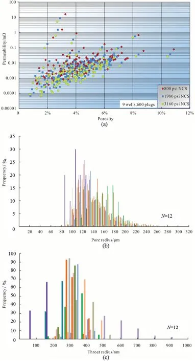
Fig.2.Main reservoir characteristics of Keshen gas field.(a)Pictures showing reservoir matrix porosity and matrix permeability in different pressure,NCS=net confining stress.(b) Histogram of reservoir matrix pore radius based on constant-rate mercury injection.(c) Histogram of reservoir matrix throat radius based on constant-rate mercury injection.
2.2.Stratigraphy and sedimentary facies
The total sedimentary rocks could reach 12,000 m thick in the Keshen gas field,and most of them are terrestrial clastic deposits[44].The Mesozoic and Cenozoic strata are also fully developed in Kuqa thrust belt [45].The Lower Cretaceous,constituted main Cretaceous in this field,is composed of the Bashijiqike Formation,Baxigai Formation,Shushanhe Formation and the Yageliemu Formation (Fig.1).However,sedimentation in the Kuqa thrust belt occurred dominantly in an oxic,shallow lacustrine setting,with a relatively arid climatic condition during the whole Early Cretaceous.As the river mouths were frequently blocked with sediments,rivers are forced to change their channels repeatedly,and deltas were often connected laterally as a result,shaping a delta apron in the mountain front[40].The depositional environment of the Keshen gas field is recognized as a fan-braided deltaic prograding setting,where clastic rocks of fan delta and braided river facies were well developed,with an abundant supply of detritus from the paleo Tianshan which located in north of Keshen gas field.The deposited sandstone has a large thickness,stable distribution,lateral continuity,and high sand ratio [46].
2.3.Petroleum systems
The Upper Triassic lacustrine mudstones and coal seams and the Lower-Middle Jurassic are the main hydrocarbon source rocks of Keshen gas field (Jin et al.,2015;Zeng et al.,2010).Besides,according to drilling evidences,the main reservoir is Bashijiqike Formation (K1bs),the upper part of K1bs was eroded to be an unconformity with the overlying gypsum mud rock of Paleogene Kumugeliemu Formation (E1-2km) which act as a regional seal for vertical gas migration[47,48](Fig.1).Anticlines related to faults are the main structural traps in the petroleum systems.Faults developed in the reservoir but not went through the cap rock played important roles for the hydrocarbon migration and accumulation[49].However,faulting and unconformity could provide pathways for gas to charge the reservoirs and has contributed to the formation of the giant gas field [50].
3.Materials and methods
In order to characterize the flow capacity(permeability)and the storage capacity (porosity) of the reservoir,rock properties measurements were performed on 600 samples of 1-inch diameter core plugs from nine wells by Core Lab in Houston using CMS-300 conventional plug analysis.To identify pore and throat radius,we choose 12 core plugs for analysis based on constant-rate mercury injection.16 core plugs are selected to identify fracture influence on permeability.Besides,1081 casting thin section samples are used to identify reservoir pore types in the petroleum geology laboratory of PetroChina Exploration and Development Research Institute in China.Then,lithology characteristics of the Bashijiqike sandstones were determined by 300 standard thin-sections grinding to a standard 30 μm thickness by microscope.Point-count analysis was performed with respect to detrital framework grains,matrix,cement,interstitial minerals,and porosity,as well as the textural modal grain size and sorting parameters using 300 points per sample.The SEM analysis was conducted on the freshly broken surface of some samples to identify pore characteristics and types of pore-filling constituents.153.3 m long core with natural fractures are observed in detail to calculate the filled fracture percentage.Electron micro probe analyzer(EMPA)is used to identify dissolution minerals,both CT scanning and Confocal Laser scanning are used to show micro fracture and pores connection,and stable isotope analyses (carbon and oxygen) were performed on 22 samples from core fracture cements to show the temperature they were formed.24 hydrocarbon &saline inclusions are tested for homogenization temperature to identify hydrocarbon accumulation time in different blocks.
4.Results
4.1.Reservoir space characteristics
According to the results of core plug testing in different pressures,the ultra-deep reservoir shows low matrix porosity and low matrix permeability,principal value of porosity data is between 2%~8%,but most premeability values are below 0.1 mD,and all of these data show a good correlation in linear(Fig.2).Then,in order to demonstrate the reservoir pore scale and throat scale,we used constant-rate mercury injection to core plugs whose porosity data are 4%~8%,all of the evidence show that pores are in micron scale,matrix throats are in nanometer scale,90% of pore radius data are between 100 μm-200 μm,majority of throat radius data are between 200 nm-500 nm(Fig.2).In a word,these data are consistent with the notion that the ultra-deep sandstone reservoir is tight and in lower matrix space.
4.2.Characteristics and distribution of high quality reservoir
High quality reservoirs are located in upper formation.As more and more drillings have been done,more cores are picked up from the K1bs,and evidence from core plug porosity data show reservoirs with higher porosity are located in upper formation (Fig.3).According to the distance to the top of K1bs,reservoir in the first 150 m show highest porosity which could reach 9%,importantly,the pores there show higher surface porosity and great connection to each other(Fig.5),and then,porosity goes down to 4%sharply in next 100 m,lower surface porosity has been found,at last,porosity goes down to 2% slowly in last 50 m,and it is hard to find the effective pores from the casting thin section (Fig.3).
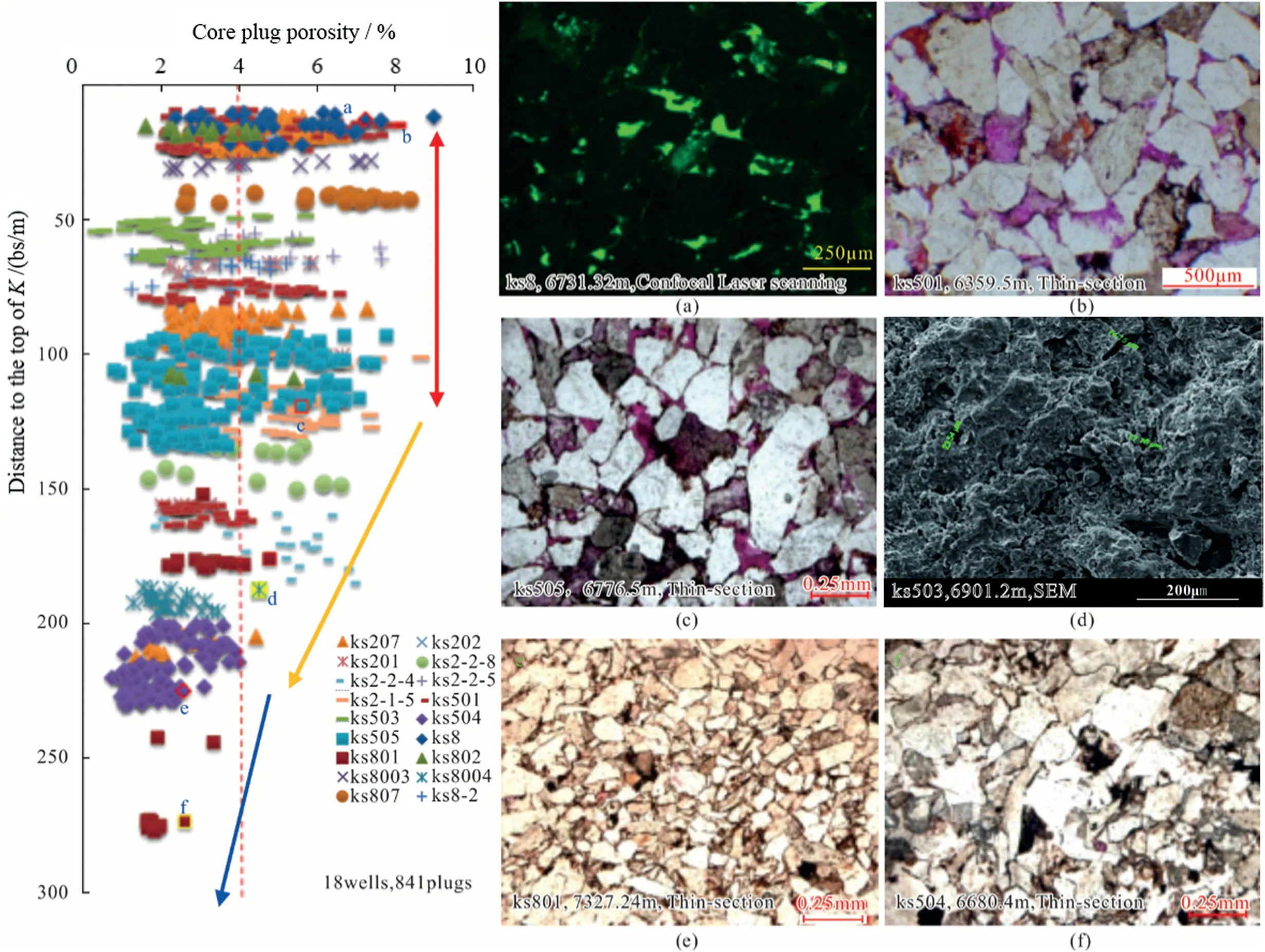
Fig.3.Core plug porosity changes with distance to the top of K1bs.6 images(a,b,c,d,e,f)showing pore morphology and face porosity,the pores in images are shown as green color in image a,dark color in image d,pink color in image b,c,e and f.
Great enhancement has been made to reservoir permeability by effective fractures.We have noticed some evidence has been found that fractures could improve the reservoir permeability greatly in Keshen gas field,but fracture porosity only make less than 0.5% in the matrix porosity[5],and reservoirs with high production always show good fracture development.However,we still want to make a quantitative analysis of fracture enhancement to high quality reservoir,so some samples with similar condition (similar depth,similar matrix porosity) are chosen to make a contrastive study.Thus,at current time,we have evidence that fractures increase reservoir permeability approximately 3 times~60 times (Fig.4a),importantly,testing results from boreholes without fracturing show fractures could increase reservoir permeability 200 times.Furthermore,even fractures filled by minerals show good connections to pores and throats(Fig.4(b),(c),(d)),some secondary micro fractures(Fig.4(e)and(f)),located around the main micro fracture,play an important role to increase permeability of high quality reservoir in Keshen gas field.
Dissolution significantly increases porosity.Researchers have find evidences about the dissolution in reservoir of Keshen gas field[39,40],but quantitative analysis of dissolution still has been a challenge.Then,1081 casting thin-sections are made from core plug covering 36 wells to show percentage of dissolved pores.As shown in Fig.5(a),reservoir spaces are divided into four types:original pore between grains,dissolved pore between grains,dissolved pore in grains and micro-fractures.However,all dissolved pores take 65.7%of the whole thin-section porosity,dissolved pores between grains take 43.4%and dissolved pores in grains take 22.3%,furthermore,there is a clear linear positive correlation between thin section porosity and core plug porosity (Fig.5(b)),so dissolution could significantly increase reservoir porosity.Moreover,evidences from Electron micro probe analyzer(EMPA) show most dissolution of the minerals is caused by feldspar(Fig.5(c),(d),(e)).
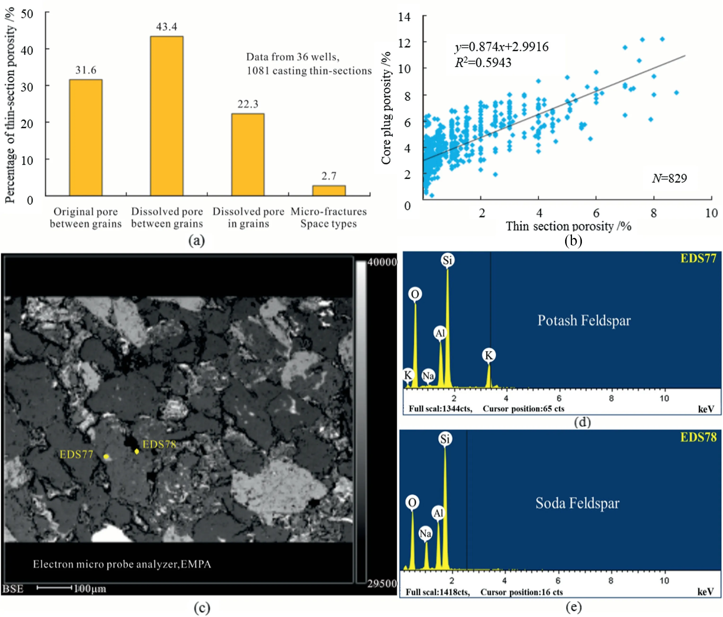
Fig.5.Dissolved pore types and dissolved minerals.(a)Histogram of pore types.(b)Electron micro probe analyzer(EMPA)image showing dissolved pore(dark color)and analysis points locations.(c)Result of dissolved mineral in EDS77 point.(d) Result of dissolved mineral in EDS78 point.
4.3.Fluids influence dissolution distance and fracture cements
We have mentioned feldspar is the main dissolved mineral above (Fig.5),then results from the thin-sections show more dissolved pores located on the upper reservoir which means stronger dissolution were developed there (Fig.6),dissolution turns to weaker with the depth,importantly,it is changed with the mounts of remaining feldspars,both of them show a very good positive correlation (Fig.6).Besides,the dissolved porosity indicates three waves with the depth,and the whole thickness of dissolution could be approximate 150 m.

Fig.6.Correlations between rock mineral changes and thin-section porosity of dissolved pore,less remaining feldspars indicate stronger dissolution and more dissolved pores.
The details of core fracture observation suggest that fractures near the unconformity show higher percentage of cements,it indicates the gypsum (gap rock) fluid with influence on the upper fractures of K1bs,and the average cement percentage is approximate 80%,the cement distance is approximate 50 m(Fig.7)which indicates limited range of fluid activity in confined-space.Besides,according to the comparative analysis of filled fractures in water zone and gas zone,fractures in water zone show higher percentage of cements which indicates stronger dissolution in gas zone and stronger cementation in water zone,and the average cement percentage is approximate 60% (Fig.7).
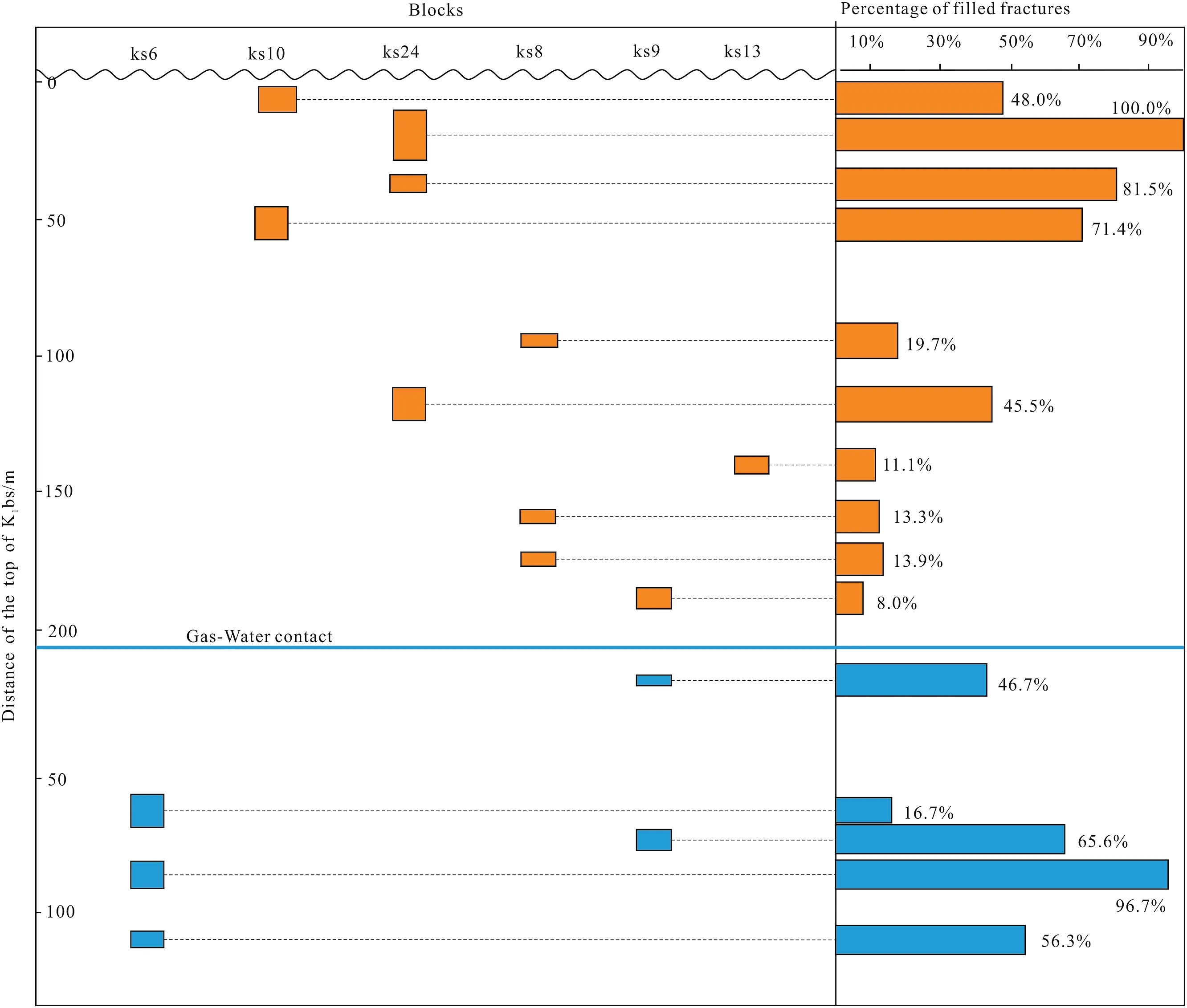
Fig.7.Map showing natural fractures of cores in depth,showing percentage of the filled fractures between gas zone and water zone.
5.Discussion
5.1.Evolution stages of enhancement
In fact,whole reconstruction evolution is a continuous process for the reservoir,but it could be identified by some typical characteristics:fracture evolution could be divided into different stages due to tectonic evolution characteristic;furthermore,it is a stable and convenient way to test the carbon and oxygen isotope compositions of the carbonate [51-53].According to observation of core fractures,lots of fractures are filled with carbonate(most of the fillings are calcites) [36,54].42 samples from fracture fillings covered different blocks are tested to identify carbon (δ13) and oxygen (δ18) isotopes,some of them are shown in Table 1.
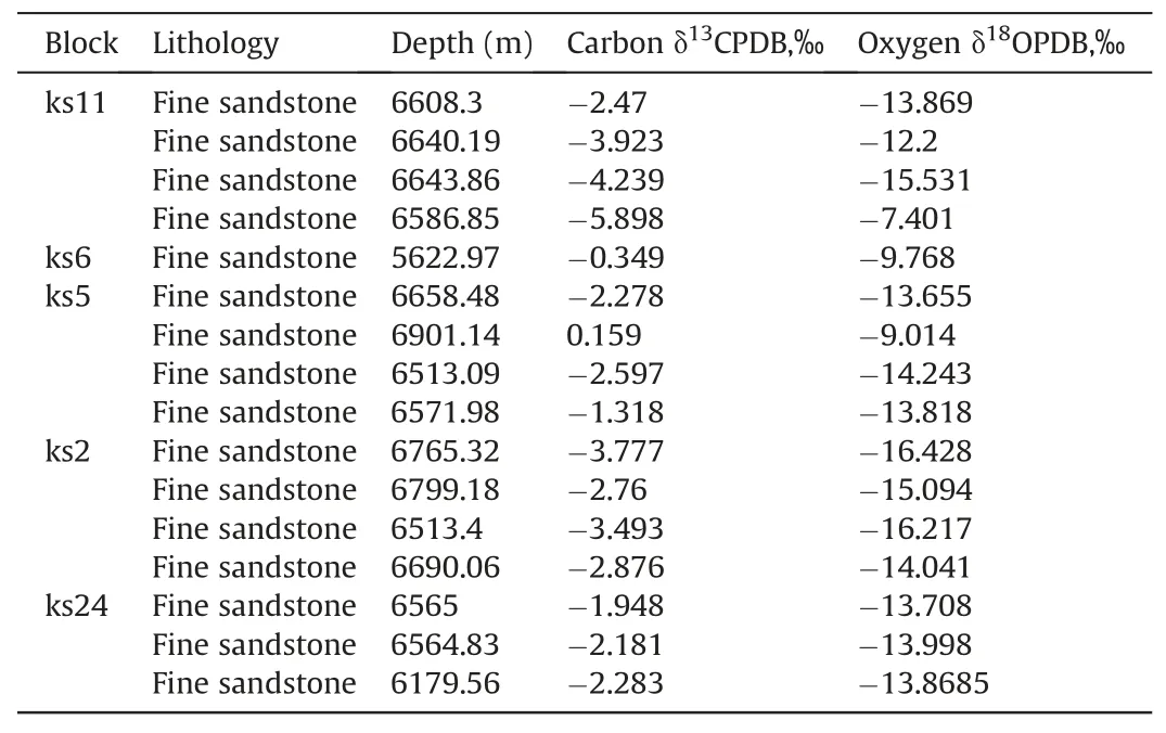
Table 1 Some data of carbon and oxygen isotopes of fracture fillings.
However,we can calculate the paleo geothermal by theformula(T=31.9-5.55(δ18O-δ18Ow)+0.7(δ18O-δ18Ow)2) proved by Epstein(1953),T in the formula means paleo geothermal when the fracture cement were formed,δ18Owmeans oxygen isotope of the underground water when the fracture cement were formed.Then,according to sediment environment of K1bs,we select the value of δ18Owas-8‰.All results of the geothermal are consistent with the hydrocarbon accumulation time: there are no fracture cement developed after hydrocarbon accumulation in the reservoir(Fig.8),and different blocks show different hydrocarbon accumulation time,blocks (block 13) in the south show later hydrocarbon accumulation time.There are 3 stages of fracture development due to the regional tectonic evolution [5,39]: from 65 Ma to 23.3 Ma,because smaller paleo-stress,there are just some N-S fractures were developed,and then,from 23.3 Ma to 4.5 Ma,with larger paleo-stress,more and more N-S fractures were developed and some W-E fracture could be developed during folding,at last,with largest paleo-stress,both most N-S fractures and most W-E fracture were developed in fold(Fig.8).The angle of internal friction of K1bs is 28°,so all shear fractures are shown in smaller included angle.Besides,dissolution porosity data from thin section analysis show that dissolution continue to contribute to reservoir after hydrocarbon accumulation,and dissolution could offer approximate 4% porosity to reservoir totally.
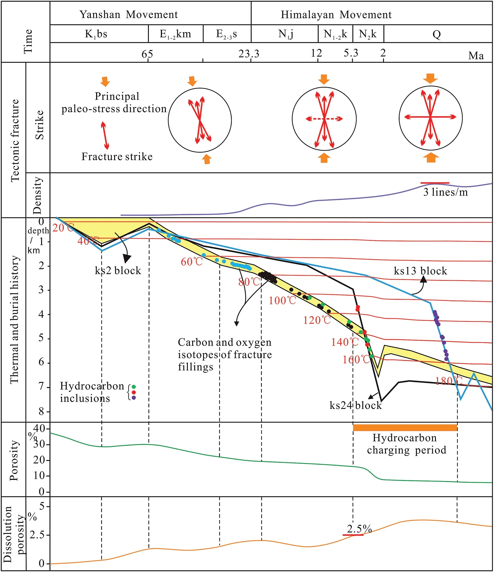
Fig.8.Evolution map of paleo-stress,fractures' strikes,and fracture density in the folds&thermal history,burial history and porosity in Keshen gas field(Modified from Wang,2018),dissolution porosity data comes from thin section analysis.
5.2.Tectonism controls fracture evolution and guides fluid flow
It has been found thrusting comes from Tianshan Mountain located in north Tarim Basin [42,43],so there has been tectonic framework of high in the north and low in the South,this framework controls the direction of fluid flow (Fig.9) and types of diagenetic fluids.More evidences have been found there are different diagenetic fluids in different blocks of Keshen gas field[36,55] which control fracture filling types.However,the matrix cements and fractures cements are important chemistry evidence for fluids activity[9,30].Most of fracture fillings from north blocks(ks5,ks6,ks10,ks2,ks24 and some parts of ks8)are calcites which indicate fresh water or weak alkaline diagenetic fluids,but the dolomite and anhydrite fracture fillings in the south blocks (ks9,ks13) indicate strong alkaline diagenetic fluids.Tectonism guides the fluid which control the dissolution strength and dissolution distance.
According to restoration of sections across Keshen gas field(Fig.9) and reservoir evolution map(Fig.8),fracture development of folds could be divided into 3 stages: all folds were thrusted slowly at that time,so only few shear fractures were developed randomly in some parts of the fold in stage 1,K1bs stays in a low depth for a long time due to the slow thrusting in the earlier time,and there were just minority of fractures were developed;however,dissolution is important to enhance reservoir prosity [30,35],in stage 1,most fluid went down from the unconformity of the top of K1bs to make the dissolution which was developed on surface of some grains (feldspar) by plenty of near-surface terrestrial water,then,with buried depth larger,temperature was increasing,nearsurface terrestrial water dissolution turned weak and dissolution in grains was strengthen.Furthermore,stage2 and stage3 are very important,the total thrust replacement reaches 5.6 km,all folds were formed with a large number of shear fractures and extensional fractures due to sharply thrusting and folding in a very short time.At the same time,hydrocarbon fluid accumulated in the reservoir by faults and fractures,both grains surface dissolution and grains inside dissolution were develop heavily.
Thrusting offers powerful energy for hydrocarbon accumulation highway,especially to tight sandstone[34,56].The source rocks are mudstones or coal zones from Jurassic formation and Triassic formation (Fig.1),strong thrusting in source rock offer powerful energy to the gas migration,plenty of gas were pumped into the K1bs reservoir by guiding of the faults and fractures (Fig.10).However,the north blocks (ks10,ks6 and ks2) are formed before the gas accumulation,so cements could be developed in some zones and gas accumulation needs more energy,and the south blocks (ks9,ks13)are formed after the gas accumulation,but the middle blocks(ks8,ks24)are formed when the gas accumulation,recoil fault and fractures could offer stronger highway for gas migration,so there is no water has been found from these blocks.

Fig.10.Strains lead to the different hydrocarbon accumulation(A)Model of hydrocarbon accumulation of Keshen gas field.(B)Strain model of original formations and hydrocarbon migration.
5.3.Model of the sweet point reservoir
Tectonism make lots of fractures which improve the permeability ultra-deep tight gas sandstones reservoir,but the fractures also could be highways for different diagenetic fluids [54,56].However,there were less shear fractures were developed in the folds in the earlier time (stage1 and stage2),but some cement layers could be formed in some parts of the fold(Fig.11),and most fluid which came from the top unconformity went down to dissolve some grains,it enhanced the reservoir porosity greatly.More importantly,plenty of fractures were developed in later time when the gas accumulation,fractures located in upper layers show larger aperture and longer length in space,all these characters help gas migrate in upper reservoir,at the same time,fractures in lower layers show smaller aperture and higher density,then,with thrusting stronger,so they are easier to be cemented by calcium rich ionic fluid from the lower mudstone layers(Fig.11),hence,the calcareous cemented layer are formed by unite effect of fractures and fluid.At last,when gas accumulated in the upper layers,dissolution continued there,but cementation in lower layers where water stays.
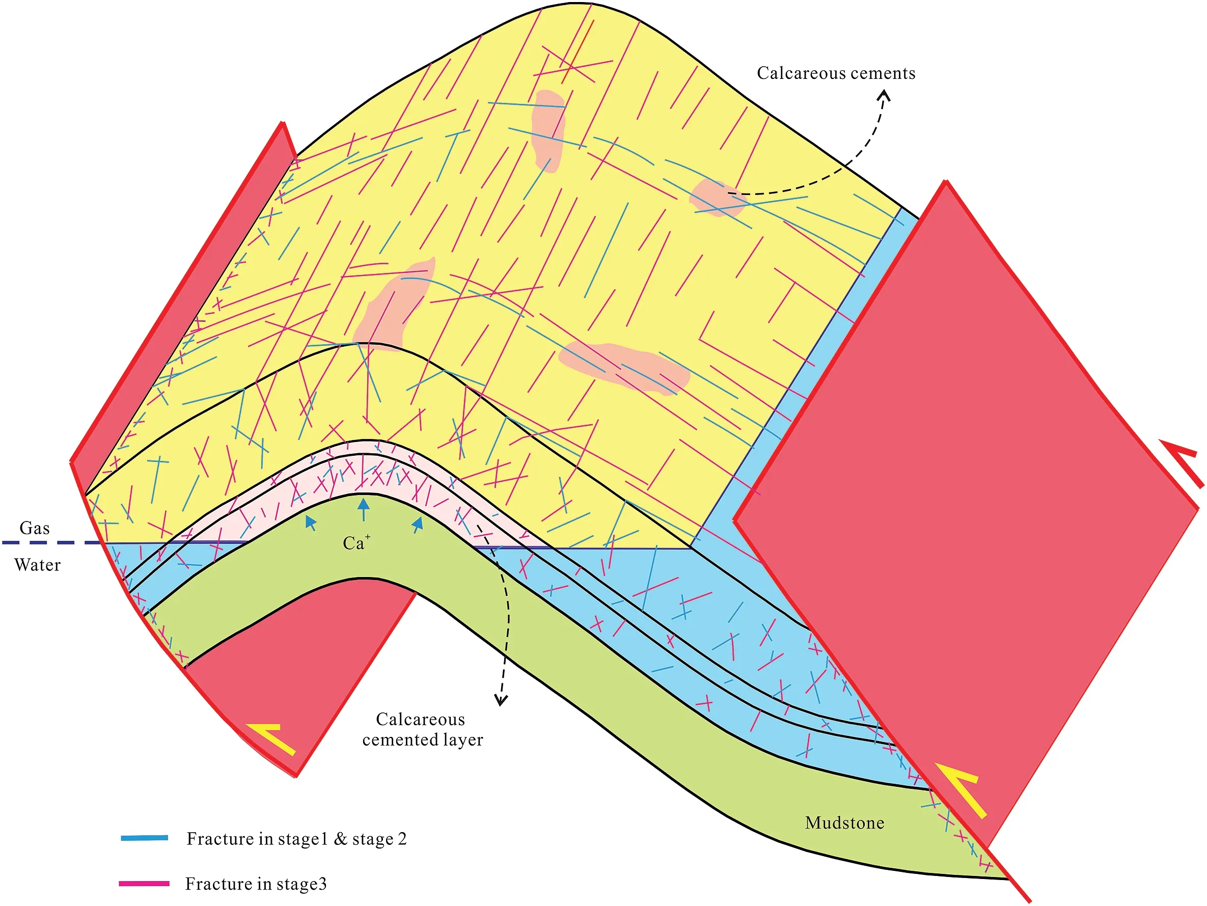
Fig.11.Fracture distribution and fluid diagenesis model to high quality reservoir.
6.Conclusions
The ultra-deep tight gas sandstone reservoir of Tarim basin shows micron scale pores and nanometer scale throat.The majority of pore radius are between 100 μm-200 μm,throat radius is between 200 nm-500 nm.Higher quality reservoirs are located in upper formation whose thickness reaches approximate 150 m.
Both tectonism and fluid enhance the reservoir quality greatly in 3 stages.Tectonism produces lots of fractures in stage 3,these fractures make the ultra-deep tight reservoir permeability increase 10-200 times (reaching 20 mD),main fluid dissolutions are developed in stage 1,raising this tight reservoir porosity 1-2 times(reaching 12%).
Tectonism and fluid interacts on each other to control the dissolution strength and dissolution distance.On one hand,tectonism controls fracture evolutions and types of diagenic fluid,on the other hand,fluids produce fracture cements and dissolution.For this ultra-deep tight reservoir,sweet point locates in upper layers,it develops fractures with larger aperture and longer length,moreover,it shows higher porosity with stronger dissolution.
Declaration of competing interest
The authors declare that they have no known competing financial interests or personal relationships that could have appeared to influence the work reported in this paper
Acknowledgement
The authors greatly acknowledge the PetroChina Tarim Oilfield Company for providing information and other support.We are thankful for Stephen Ernest Laubach,Bo Ren and Qiqi Wang from Bureau of Economic Geology,for providing constructive comments and suggestions,which improve our manuscript significantly.This work was supported by the reservoir research project of PetroChina(No.2021DJ0302).
杂志排行
Petroleum的其它文章
- Super gas wet and gas wet rock surface: State of the art evaluation through contact angle analysis
- Petroleum system analysis-conjoined 3D-static reservoir modeling in a 3-way and 4-way dip closure setting: Insights into petroleum geology of fluvio-marine deposits at BED-2 Field (Western Desert,Egypt)
- Development and performance evaluation of a high temperature resistant,internal rigid,and external flexible plugging agent for waterbased drilling fluids
- Anti-drilling ability of Ziliujing conglomerate formation in Western Sichuan Basin of China
- Production optimization under waterflooding with long short-term memory and metaheuristic algorithm
- Investigation of replacing tracer flooding analysis by capacitance resistance model to estimate interwell connectivity
