Current Status and Main Application Achievements of Ocean Satellites
2022-08-18LINMingsenZHANGYouguang
LIN Mingsen ZHANG Youguang
(National Satellite Ocean Application Service, Beijing 100081)
Abstract Ocean satellites have realized multi-satellite networked operation.The HY-1D satellite launched in June 2020 realized networked with HY-1C satellite,and completed the construction of ocean color satellite constellation.The HY-2D satellite launched in May 2021 is networked with the on orbit HY-2B and HY-2C satellites to complete the construction of marine dynamic environment satellite constellation.The 1mC-SAR satellite 01 launched in November 2021 is networked with GF-3,which initially forms the marine monitoring satellite constellation.This year,the networking of 1mC-SAR satellite 02 with satellite 01 and GF-3 is realized,and the construction of marine monitoring satellite constellation is completed.At present,the ocean satellites have the operational application capabilities of remote sensing investigation,monitoring,evaluation and supervision of marine ecology,marine disaster prevention and reduction,global oceans and Polar Regions,Sea Islands,rights and interests maintenance.
Key words Ocean color satellite,Ocean dynamic environment satellite,Ocean monitoring satellite,Satellite networking
1 Introduction
Since the launch of the first ocean satellite on 15 May 2002,10 ocean satellites have been launched,including HY-1A/1B/1C/1D,HY-2A/2B/2C/2D,CFOSAT,GF-3 and C-SAR satellites.At present,HY-1A/1B have stopped working,HY-2A has degraded,and the rest of the satellites work normally in orbit,as shown inFig.1.
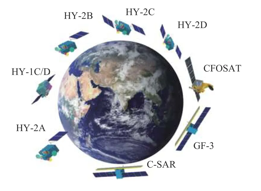
Fig.1 Ocean satellites currently in orbit
The ocean satellite has realized networking operation of multiple satellites.The HY-1D satellite launched in June 2020 realized networked with HY-1Csatellite,and completed the construction of ocean color satellite constellation.The HY-2D satellite launched in May 2021 realized networked with the on orbit HY-2B and HY-2C satellites,and completed the construction of ocean dynamic environment satellite constellation.In November 2021,1 mC-SAR satellite 01 was launched to form a network with GF-3,initially forming an ocean monitoring satellite constellation.This year,the networking of 1 mC-SAR satellite 01,02 and GF-3 was completed,and the construction of ocean monitoring satellite constellation was completed.At the same time,the quality of ocean satellite data products has also been steadily improved.Among them,the quality of sea surface height data of HY-2 series satellites has also been fully recognized by foreign scientific research institutions.After many evaluations,scientists of the CNES believe that the sea surface height data obtained by HY-2 series satellites has high precision,at the same precision level as that of satellites in Europe and America.The numerical prediction products provided by Eumetsat to users around the world are recognized as the highest quality marine and atmospheric data products,in which the initial information required for model operation is contributed by the sea surface wind field data of HY-2 series satellites[1–3].
In addition,a new generation of polar orbit ocean dynamic environment satellite,salinity satellite,high orbit ocean and coastal zone environment monitoring satellite,a new generation of ocean color satellite and HY-2E/F satellite will be launched to further enrich and improve the ocean satellite observation system.
2 Function of on Orbit Ocean Satellite
Ocean satellites are designed according to the detection technical capabilities and characteristics of different elements,time and space resolution,coverage and monitoring frequency requirements.They are divided into three categories according to their uses,including ocean color environment,ocean dynamic environment and marine monitoring series.
HY-1 series satellites are used for ocean color,ocean temperature and coastal zone observation.HY-1A/1B are experimental satellites,equipped with ocean water color and water temperature scanner and coastal zone imager.HY-1C/1D is an operational satellite,equipped with ocean color and temperature scanner,coastal zone imager,ultraviolet imager,calibration spectrometer and ship automatic identification system.They are networked for land and sea observations in the morning and afternoon sectors.The payloads have the advantages of multiple spatial resolution,high signal-to-noise ratio,high dynamic range and wide swath.
HY-2 series satellites are used to monitor various marine dynamic environmental parameters such as allweather global sea surface wind field,wave height,sea surface height and sea surface temperature,directly provide measured data for early warning and prediction of disastrous sea conditions,and provide support services for marine disaster prevention and reduction,maintenance of marine rights and interests,development of marine resources,marine environmental protection,marine scientific research and national defense,The payloads are radar altimeter,microwave scatterometer,microwave radiometer,dual frequency global positioning system,ship automatic identification system,data collection system,two-way data communication,etc.HY-2A is the experimental satellite,and HY-2B/2C/2D have realized operational networked observation.
Marine Surveillance and monitoring series satellites are used for all-weather monitoring of the global marine and land information.The payload is a C-band multipolar synthetic aperture radar.They are used in many fields such as marine,disaster reduction,water conservancy and meteorology.They are an important technical support for China’s implementation of marine development,land environmental resources monitoring and emergency disaster prevention and reduction.The experimental satellite is GF-3 satellite,one follow-up satellite,1 m C-SAR-02,to be networked with GF-3 and 1 m C-SAR-01 satellite,will be launched in 2022.
International cooperative experimental satellite:CFOSAT is a scientific research experimental satellite cooperated by China and France.China provides a scatterometer and France provides an ocean spectrometer.Its main task is to obtain global sea surface wave spectrum,sea surface wind field and polar sea ice information,and further strengthen the scientific understanding of the rules of marine dynamic environmental change;to improve the accuracy and timeliness of forecasting catastrophic sea conditions such as huge waves,marine tropical storms and storm surges;at the same time,to obtain the relevant data of polar ice sheet to provide basic information for the study of global climate change.
2.1 Satellite Payload Configuration,Orbit and Working Mode
The satellite payloads are configured according to mission requirements,detection means and constraints.The configured payloads include ocean color and temperature scanner,coastal zone imager,ultraviolet imager,calibration spectrometer,radar altimeter,microwave scatterometer,microwave radiometer,correction radiometer,synthetic aperture radar,ocean spectrometer,global positioning system,ship automatic identification system,etc.The detection means cover ultraviolet,visible light,near infrared,infrared and active and passive microwave remote sensing.There are many varieties to achieve high quantitative accuracy.
The on orbit ocean satellites HY-1C/1D,HY-2B,CFOSAT and GF-3 are in solar synchronous orbits.The local time for global exploration is basically the same every day.They pass through China’s sea areas in the early morning and evening.Each satellite works 24 h a day and flies 14 or 15 times around the north and south poles every day.HY-2C/2D satellite is in Non solar synchronous orbit and is networked with HY-2B to improve the observation timeliness of marine dynamic environmental parameters.
All satellites work 24 h,and most of the payloads have the capabilities to realize the detection of the world,north and south poles,coastal zones and islands.The coverage width of each payload is 10–3000 km,and the coverage period is 1–3 days.The coverage period of a remote sensing payload with large scanning width is short,while the coverage period of a remote sensing payload with small scanning width is long.The widest coverage is the ocean color and ocean temperature scanner,with a scanning width of 3000 km.It covers the whole world every day and night.The scatterometer has a width of 1300–1750 km,and it observes once in the morning and evening to realize the observation of the whole world once every two days.
2.2 Ocean Satellite Can Also Be Used for Large-scale Land Monitoring
Ocean satellites can not only monitor the ocean,but also obtain rich information when passing through the land.GF-3 satellite itself is a satellite for both land and sea,which can monitor water and land surface all day.HY-1C/1D satellite has large payload scanning width and short data acquisition cycle.It is designed for water body,with a large dynamic range,high signal-to-noise ratio and good radiation performance.It is also a powerful tool for a general survey of land natural resources,ecological environment,flood disaster and forest fire monitoring.
2.3 Integrated Management of Satellite Ground System,Fast Data Acquisition
The operation of ocean satellites is under the unified responsibility of the national satellite ocean application service,which is responsible for the whole process of satellite exploration planning and control,real-time data reception of multiple ground stations,data communication transmission,standard product production,data calibration and product validation,product archiving and distribution.The multi-satellite operational production chain is complete.The integrated satellite ground operation system of the ocean satellites is becoming more and more perfect,and the operational capability of ocean satellite network is basically formed.In the process of ocean satellite processing,for the domestic detection data,the product production shall be completed within one hour after receiving the data;overseas data is processed through delayed playback,with a delay of between 2 h and 12 h.
3 Typical Application Results
3.1 Seas Surface Fields and Significant Wave Height Networked Observation
3.1.1 Radar Altimeter Networking
HY-2B,HY-2C and HY-2D radar altimeters have realized three-satellite networked observation,and the spatial coverage and timeliness have been synchronously improved.Figs.2–3show the joint observation of significant wave height and sea surface wind speed by HY-2D and its joint HY-2B and HY-2C radar altimeters during typhoon IN-FA on 24 July 2021.In the figure,it can see the local area with extreme value of wind and wave caused by typhoon in Northeast Taiwan.
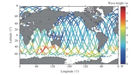
Fig.2 Significant wave height by HY-2B,HY-2C and HY-2D altimeters on 24 July 2021
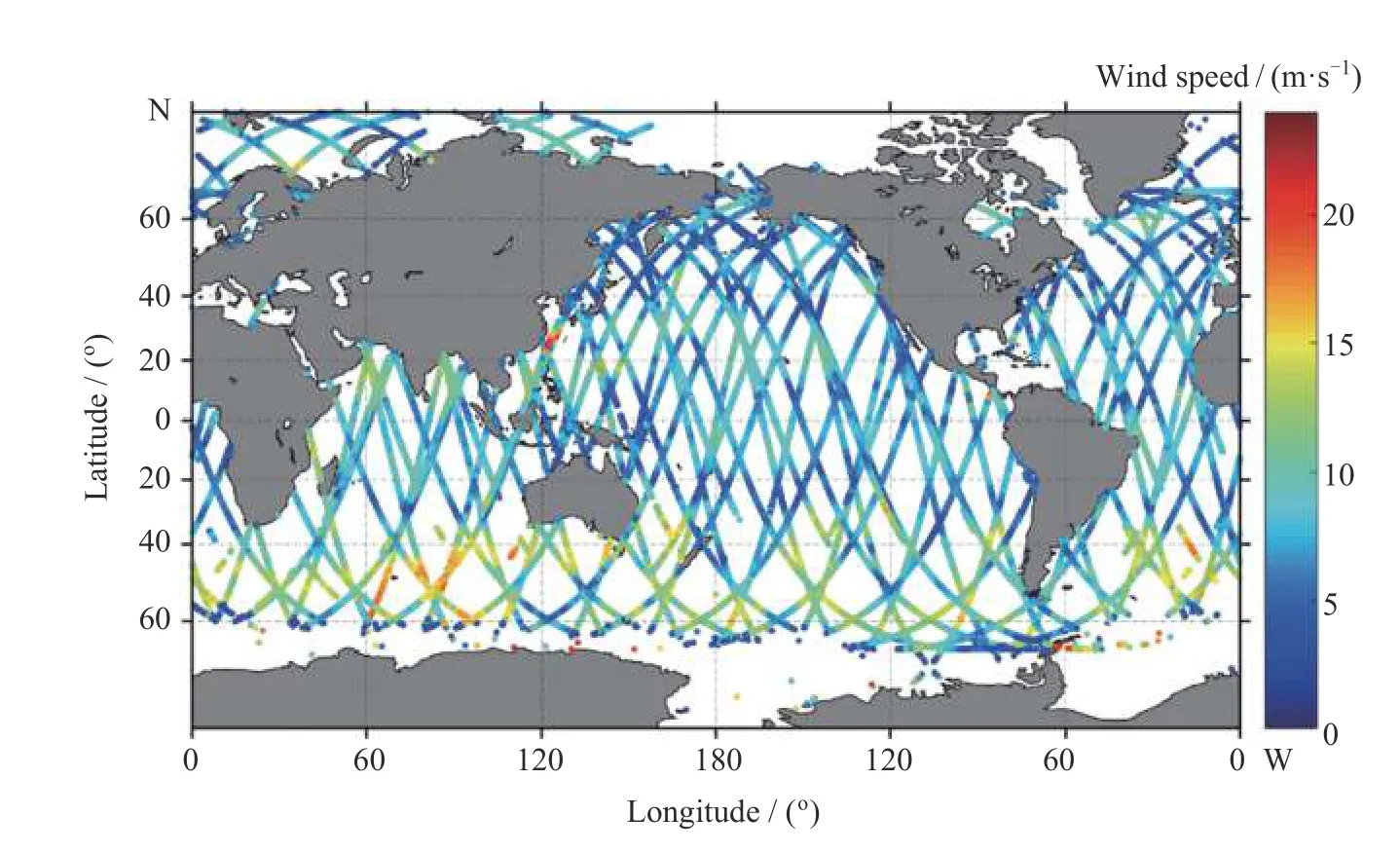
Fig.3 Sea surface wind speed by HY-2B,HY-2C and HY-2D altimeters on 24 July 2021
3.1.2 Microwave Scatterometer Networking
The microwave scatterometer of HY-2B,HY-2C and HY-2D satellites realizes networked observation.The average observation area of each satellite is 1500 km.In typhoon observation,it has the advantage of a larger observation area than similar satellites (e.g.MetOp Series).This network can cover 80% of the globe in 6 h,as shown inFigs.4–7.It should be pointed out that the microwave scatterometers carried on HY-2C and HY-2D are the only non-solar synchronization satellite scatterometers in orbit in the world.which make complementary observations together with HY-2B satellite scatterometer in the polar orbit,conducive to calibration and validation.
3.2 Polar Observation
Ocean satellite is one of the effective tools for polar monitoring and research.Since the launch of HY-1C/D satellite into orbit,13694 images with a spatial resolution of 50 meters between 66.5° and 86.0° north latitude in the Arctic Circle have been obtained,each with an image size of 1000 km×360 km.Among them,HY-1C satellite has 9341 images and HY-1D satellite has 4353 images,which are used to recognize,discover and study the landform,ice sheet,glacier,sea ice,iceberg,and river.The distribution and daily,monthly and seasonal variation of characteristic parameters such as ocean color,snow cover and cloud system provide a new data source.In some areas,the annual variation characteristics of some parameters in recent three years can also be analyzed.
Measured from the obtained ocean satellite remote sensing images,the actual area of the young pioneer island is about 1535 square kilometers and the circumference is about 219 kilometers.As can be seen from the image on 1 August 2020 inFig.8,except for the glacier on the young pioneers Island,all the land ice and snow on the island have melted,and the frozen soil layer is exposed.Its shape and color are similar to that of a copper carving board inlaid with a piece of jewelry or a piece of chocolate,or a large oil cake superimposed with a fried egg.The sea ice around the young pioneers island is gradually decreasing.In mid and late August,the surrounding sea ice almost completely melted,and some land began to be covered with snow in late September.The image of April 2021 shows that the whole island is white and covered with snow.The ice cap on the island is raised.The frozen soil layer begins to appear in June,and the snow continues to decrease in July.By 3 August 2021,some ice and snow on the land will melt,but the snow area of the ice cap on the island has not decreased compared with last year.
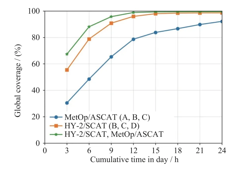
Fig.4 Observation coverage of HY-2 satellite and MetOp satellite scatterometer
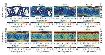
Fig.5 Observation coverage area of HY-2B/C/D scatterometer in different periods
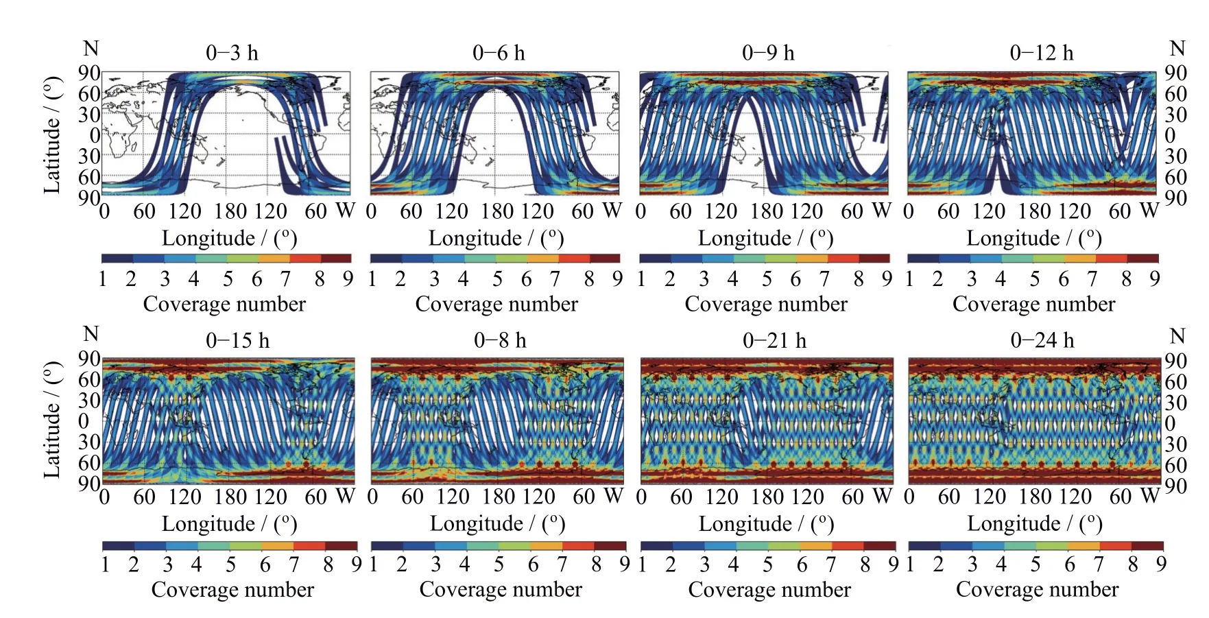
Fig.6 Observation coverage area of MetOp ASCAT-A/B/C/scatterometer in different periods
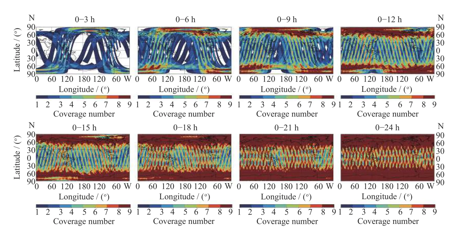
Fig.7 Observation coverage area of HY-2B/C/D and MetOp ASCAT-A/B/C scatterometer in different periods

Fig.8 Remote sensing images of young pioneer island observed by HY-1C and HY-1D satellites
3.3 Typhoon Observation
The visible light,near infrared,thermal infrared channels and ultraviolet channels of the HY-1C/D satellite ocean color water temperature scanner can obtain the global distribution of surface vegetation and clouds.The multi-satellite network can obtain the typhoon wind field,cloud rainfall distribution,change state,influence range and moving path many times a day.At 01:25 LT on 22 July 2021,the Typhoon In-Fa was observed by the thermal infrared channel of ocean color and water temperature scanner of HY-1D satellite,the typhoon eye is very clear,and the typhoon intensity reaches level 14 inFig.9.

Fig.9 Typhoon In-Fa thermal infrared cloud image of ocean color water temperature scanner
3.4 Hurricane Observation
Ocean satellites can also observe hurricanes at high frequencies.On 29 August 2021,hurricane Ida landed in Louisiana in the southern United States,with a maximum wind speed of about 240 km·h–1.HY-2B/2C/2D network continuously observed the hurricane landing process and corresponding wind field information from 28th to 29th.From 28 to 29 August,HY-2B/2C/2D observed 8 times in total,including 3 times of HY-2B,2 times of HY-2C and 3 times of HY-2D,as shown inFig.10.

Fig.10 HY-2B/2C/2D joint observation of Hurricane Ida
3.5 Land Water Monitoring
During the period from 29 March to 31 May 2012,the HY-1C/D Satellite coastal zone imager took 42 photos of Poyang Lake area in Jiangxi Province inFig.11(left).Three times were sunny on 9 April,30 April and 1 May,with a clear sky accounting for less than 10%,and more than 90% of the time was cloudy and rainy.After being included in GF-3 satellite,two times of all-weather and all-time Synthetic Aperture Radar (SAR) data were obtained inFig.11(right).HY-1C/D satellite,GF-3 satellite remote sensing thematic map and relevant data provide a strong basis for rapid response to floods.
Fig.11 Multi-satellite monitoring of water changes in Poyang Lake
3.6 Marine Ecological Environment Monitoring
Land-based pollution emissions,marine production and operation activities,oil exploitation and transportation have led to changes in the marine ecological environment,and some endanger the marine ecological security.The impact can be continuously observed by multiple marine satellites.
3.6.1 Red tide Monitoring
Red tide is a marine ecosystem anomaly that occurs frequently in China’s offshore waters.The explosive and rapid reproduction of plankton in the ocean causes the sea water to show different colors such as yellow,green,brown and red.In recent years,HY-1C and HY-1D satellites have been used to monitor many red tide events in the Bohai Sea,Yellow Sea,East China Sea and South China Sea,and their locations and the area of influence and other important information shall be provided to relevant application departments.An example of red tide pbservation in Beibu Gulf is shown inFig.12.
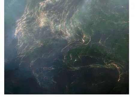
Fig.12 Red tide in Beibu Gulf
3.6.2 Green Tide Monitoring
Since the outbreak of green tide in Qingdao in 2008,green tide monitoring has become an operational monitoring work.The information of green tides in the Yellow Sea and the East China Sea has been extracted by a variety of satellite data such as HY-1/B/C/D,MODIS and GF series satellites,which has realized the early detection and whole process tracking and monitoring of green tide disasters,and provided accurate and timely information services for the prediction of green tide drift path and disaster prevention and reduction.An example of multi-satellite monitoring of green tide in Daqiao Bay is shown inFig.13.
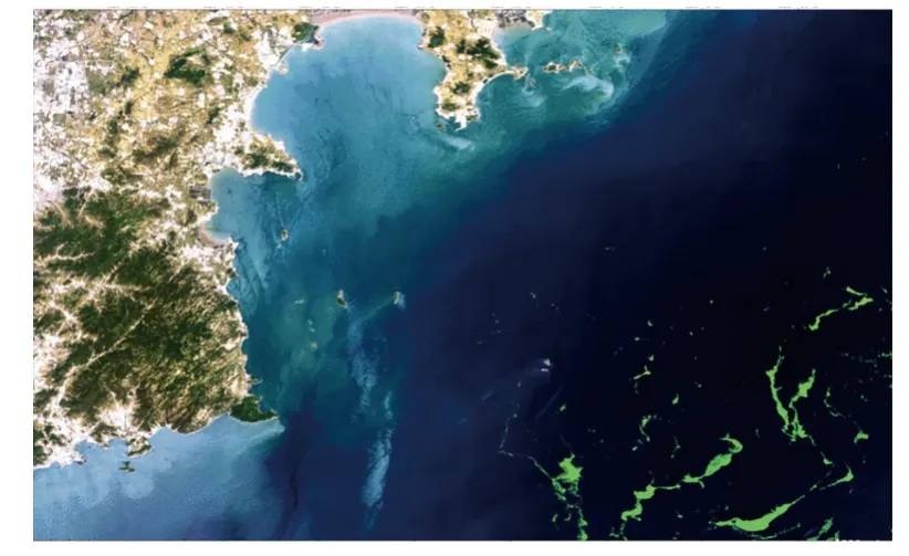
Fig.13 Multi-satellite green tide monitoring
3.6.3 Oil Spill Pollution Monitoring
Oil spill pollution does great harm to the marine environment,marine ecology and human economic life.Marine oil spill can be detected by microwave sensing,optical remote sensing,thermal infrared,ultraviolet and other remote sensors.The 50 m coastal zone imager of HY-1C and HY-1D satellites and GF-3 satellite were used to monitor multiple oil spills in the Bohai Sea,the South China Sea and the East China Sea.An example of HY-1C satellite monitoring of oil spill in offshore Indonesia is shown inFig.14.
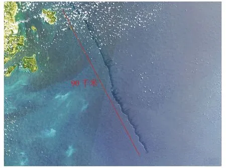
Fig.14 HY-1C-satellite monitoring of oil spill pollution
3.7 Forest Fire Monitoring
Taking advantage of the short revisit period of HY-1C/D Satellite and the high signal-to-noise ratio of coastal zone imager,effective monitoring and analysis have been carried out on forest fires in Russia,Australia,Brazil,the United States,Myanmar,Ukraine,India,Indonesia and many other countries.In China,such as Shandong,Shanxi,Guangdong,Sichuan,Yunnan,Jiangxi and Beijing,the thematic map of fire was obtained by analyzing the vegetation change and smoke direction of multi-time images during and after the disaster,and was pushed to the Emergency Management Department and the front headquarters of relevant provinces at the first time,providing effective and powerful services for emergency relief.An example of HY-1C satellite forest fire monitoring of Laojun Mountain in Lijiang is shown inFig.15.
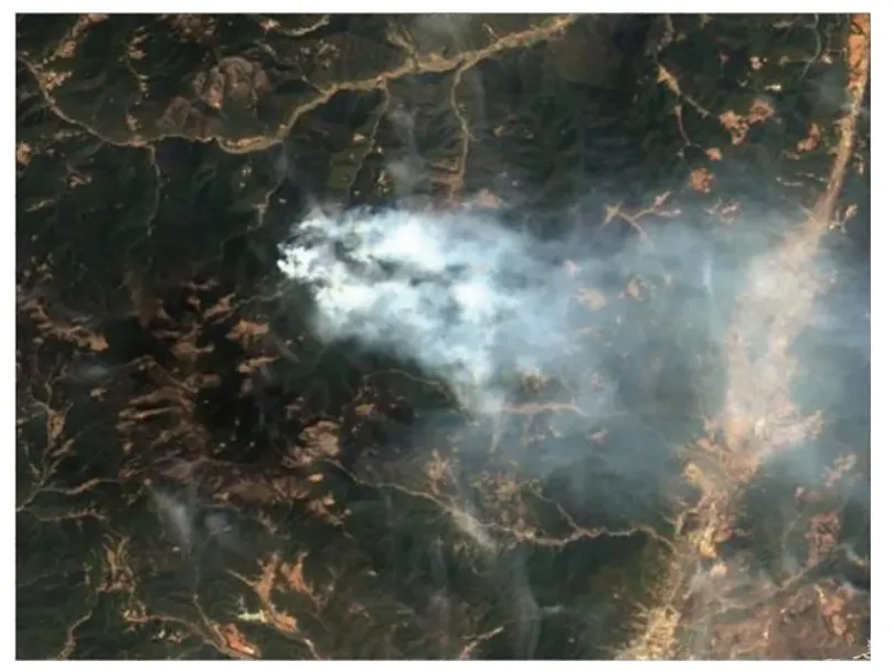
Fig.15 HY-1C satellite forest fire monitoring
3.8 Volcano Monitoring
From the image of HY-1C/D Satellite coastal zone imager on 28 February 2022 inFig.16,it is found that the volcano of Suwanosejima in Japan erupted.From the comparative analysis of the image,there are no obvious changes in the islands themselves,but the volcanic ash cloud is clearly visible.The volcanic ash cloud emitted from Suwanosejima has obvious characteristics,showing white and striped cloud system,from dense to sparse distribution,the length of volcanic ash cloud is more than 100 km.From the comparative analysis of the time series images in the morning and afternoon,the volcanic ash cloud drifts towards the southeast,and a small amount of floating objects can be seen on the sea surface,but it is not sure whether it is pumice.
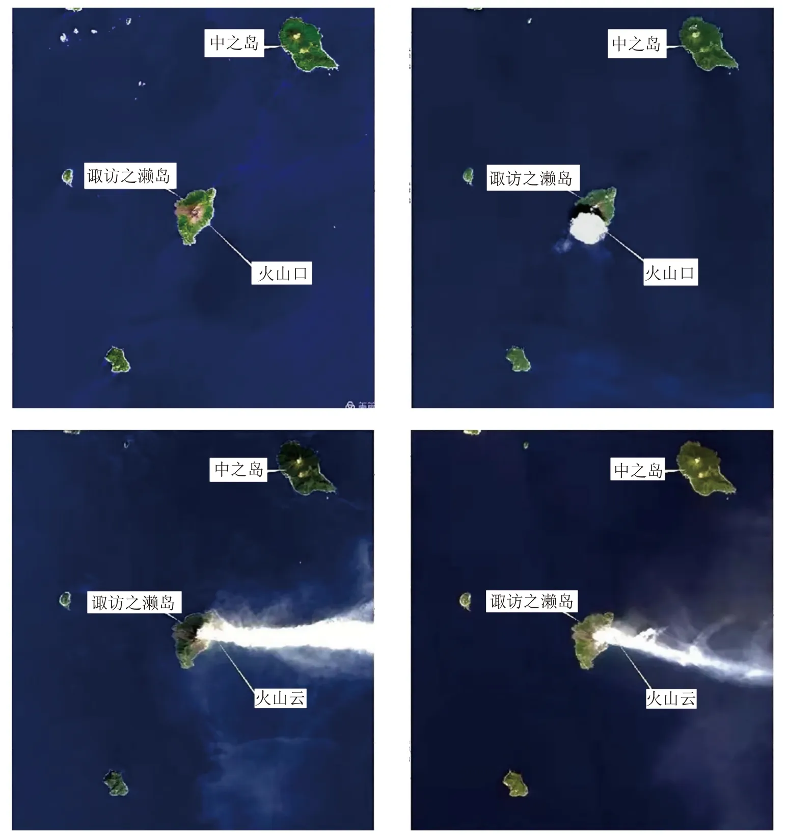
Fig.16 HY-1C/D satellite volcano monitoring
4 Conclusion
Ocean satellites have realized multi-satellite networked operation.The HY-1D satellite launched in June 2020 realized networked with HY-1C satellite,and completed the construction of ocean color satellite constellation.The HY-2D satellite launched in May 2021 is networked with the on orbit HY-2B and HY-2C satellites to complete the construction of marine dynamic environment satellite constellation.The 1 m C-SAR satellite 01 launched in November 2021 is networked with GF-3,which initially forms the marine monitoring satellite constellation.This year,the networking of 1 m C-SAR satellite 02 with satellite 01 and GF-3 is realized,and the construction of marine monitoring satellite constellation is completed.At present,ocean satellite has the operational application capabilities of satellite remote sensing investigation,monitoring,evaluation and supervision of marine ecology,marine disaster prevention and reduction,global oceans and Polar Regions,Sea Islands and rights and interests maintenance.
In the follow-up development of ocean satellites,while providing services in many fields,it is also necessary to continue to improve the monitoring capacity and expand the application service capacity in terms of satellite observation accuracy,spatial resolution and timeliness.Build a complete space-based ocean observation system with high and low orbit coordination,solar and non-solar synchronous satellites,and low,medium and high-resolution observation capabilities,so as to realize the synchronous acquisition of large,medium and smallscale marine environment information and the synchronous observation capability of the marine surface,subsurface and seafloor.
杂志排行
空间科学学报的其它文章
- Advances in China Space Medical Experiment Research
- Progress of Planetary Science in China*
- Advances in the Researches of the Middle and Upper Atmosphere in China in 2020–2022
- Magnetospheric Physics in China:2020–2021
- Space Solar Physics in China:2020–2022*
- Research Advances of the Chinese Meridian Project in 2020–2021