Subseasonal and Synoptic Variabilities of Precipitation over the Yangtze River Basin in the Summer of 2020※
2021-12-13LiudanDINGTimLIandYingSUN
Liudan DING, Tim LI*2,, and Ying SUN
1Key Laboratory of Meteorological Disaster, Ministry of Education (KLME) / Collaborative Innovation Center on Forecast and Evaluation of Meteorological Disasters (CIC-FEMD), Nanjing University of Information Science and Technology, Nanjing 210044, China
2International Pacific Research Center and Department of Atmospheric Sciences, School of Ocean and Earth Science and Technology, University of Hawaii at Manoa, Honolulu, Hawaii 96822, USA
3National Climate Center, Beijing 100081, China
ABSTRACT
Summer precipitation over the Yangtze River basin (YRB) in 2020 experienced a strong subseasonal and synoptic fluctuation in addition to contributing to an exceptionally large seasonal mean precipitation.The cause of this higherfrequency fluctuation is examined based on observational analyses.Apart from the continuous northward movement of the climatological mei-yu rainband, the mei-yu rainbelt in the summer of 2020 experienced multiple northward and southward swings.The cause of the swings was attributed to the subseasonal variability of southerly winds to the south and northeasterly winds to the north of the YRB.In addition, synoptic-scale variability, characterized by the eastward propagation of low-level cyclonic vorticity and precipitation anomalies, was also commonplace in the summer of 2020.While the strengthening of both the subseasonal and synoptic variabilities in the summer of 2020 was attributed to the increase of the background mean moisture, the synoptic variability was greatly affected by the subseasonal rainfall variability.As a result, both the synoptic-scale and subseasonal variabilities contributed to the north-south swings of the rainbelt.The large-scale modulations by both the seasonal mean and subseasonal anomalies provide insight regarding the optimization of issuing accurate, extended-range forecasts of extreme weather events.
Key words: Yangtze River precipitation, synoptic and subseasonal variabilities, meridional swings of a rainbelt, large-scale modulation of high-frequency variability
1.Introduction
The most notable meteorological feature in East Asia in boreal summer is the mei-yu front.Climatologically, the mei-yu rainband appears over the Yangtze River basin(YRB) from mid-June to mid-July, which is part of the East Asian summer monsoon system (EASM; Ding, 1994; Ding and Wang, 2008).The mei-yu front usually presents itself as a long strip-like shape elongated in a quasi-zonal direction along 30°N from eastern China through to southern Japan (Li and Wang, 2005; Si et al., 2009).It accounts for about 45% of the local summer precipitation which is consistent with the fact that the mei-yu is often accompanied by extended periods of rainfall (Wang and Lin, 2002; He et al.,2007a; Boos and Kuang, 2013).Floods associated with persistent heavy mei-yu rainfall anomalies have caused great economic loss and casualties (Zhai et al., 2005; Zhou et al.,2009; Cen et al., 2015).Due to its narrow zone and temporal fluctuations, determining the precise location of the mei-yu rainband is recognized as a challenge in operational weather and climate forecasting (Li, 2010).Thus, exploring the observed features and physical mechanisms of summer precipitation variabilities over the YRB is of great importance.
The onset of the mei-yu season over the YRB signifies the northward shift of the EASM (Li and Wang, 2005;Sampe and Xie, 2010; Luo et al., 2013), which is associated with the evolution of large-scale atmospheric circulations such as the western Pacific subtropical high (Tao and Chen, 1987; He et al., 2007b), the upper-tropospheric westerly jet stream (Yang et al., 2004; Xuan et al., 2011), and the low-level southerly winds (Wu, 2017).The interannual variability of the EASM is affected by various factors(Wang and Chen, 2012), including land-sea thermal contrast (Wu et al., 2007; Zhang et al., 2017) and moisture transport (Webster, 1983).The mei-yu rainband is characterized by a quasi-stationary, zonally-oriented pattern with sharp moisture gradients but relatively weak temperature gradients (Ding and Chan, 2005; Sampe and Xie, 2010).Pronounced southerly flows to the south transport moist and warm air to meet relatively dry and cold air from the north(Chen et al., 2010, 2017).
The average period of the mei-yu rainfall over the YRB is about three weeks (Ding, 1992), but there are large interannual fluctuations (Chang et al., 2000a, b; Lu et al., 2001;Wang et al., 2003).A wave train along the “Silk-Road” may be conducive to the developments of the subtropical front(Hong et al., 2018).The Pacific-Japan pattern may affect the mei-yu in East Asia through the modulation of the intensity and position of the subtropical westerly jet, the western Pacific subtropical high, and the South Asia high (e.g.,Chen and Zhai, 2015; Shang et al., 2020).In addition, the mei-yu rainfall period also experienced an interdecadal variation.For example, Ding et al.(2008) pointed out that a climate shift of the EASM happened in the early 1990s, accompanied by a large-scale atmospheric circulation change.Zhu et al.(2011, 2015) attributed a decadal change of summer precipitation in the Huang-Huai River and the Yangtze River regions around 2000 to the phase shift of the Pacific Decadal Oscillation.
A marked diurnal variation occurs in the mei-yu rainfall period (Chen et al., 2010, 2017; Bao et al., 2011; Xu and Zipser, 2011).While frequent nocturnal long-duration rainfall events contributed to an early-morning rainfall maximum over the YRB, deep convection produced an afternoon peak (Chen et al., 2010; Xu and Zipser, 2011).The summer rainfall along the YRB also experiences great subseasonal variability, as the local precipitation anomalies are often highly correlated with atmospheric intraseasonal oscillations (ISOs) in the tropics and subtropics (Li et al., 2015; Qi et al., 2016; Ding et al., 2020; Yang et al., 2020).
The mei-yu in the summer of 2020 produced a recordbreaking rainfall amount over the YRB relative to the past 60 years.The average precipitation amount over the middle and lower reaches of the Yangtze River during the period(from June 8 to July 21) was 435.1 mm, which is the largest since 1961 (Cui et al., 2021).The precipitation anomaly was accompanied by persistent low-level southerly (northerly) anomalies to the south (north) of the mei-yu front in June-July 2020 (Wang, 2020; Pan et al., 2021).
The objective of the present study is to reveal the higher-frequency (subseasonal and synoptic-scale) variations regarding the characteristics of the precipitation over the YRB in the summer of 2020 and to determine physical mechanisms responsible for the higher-frequency variability.It is anticipated that the investigation of the higher-frequency mei-yu rainfall variability will benefit the improved skill of extended-range forecasts of extreme weather events.
The remaining part of this paper is organized as follows.In section 2, we provide a brief review of the data and methods used in this study.In section 3 we describe the observational characteristics of the atmospheric circulation anomalies associated with the Yangtze River flood in June-July 2020 with a particular focus on the high-frequency, northsouth swings of the mei-yu rainband.A detailed comparison of subseasonal and synoptic rainfall variabilities along the YRB between the climatology and the summer of 2020 is given in section 4.In section 5 we discuss the relative contributions of the subseasonal and synoptic variabilities to the high-frequency swings of the rainband and the modulation of the synoptic-scale mode by the subseasonal variability.Finally, a conclusion and discussion are given in the last section.
2.Data and methods
The primary dataset used for the current study is the European Center for Medium-Range Weather Forecasts(ECMWF) Re-Analysis 5 (ERA5; Hersbach et al., 2019)with a horizontal resolution of 0.25° × 0.25°.This dataset includes hourly precipitation, specific humidity, temperature, geopotential height, vertical velocity, and wind fields covering 1979 to 2020.The daily average datasets are interpolated into a 1° × 1° resolution grid via bilinear interpolation.The anomaly fields are defined as the departure from the long-term (1979—2019) climatology.All the analyses are conducted in the June-July period.
A power spectrum analysis is applied to reveal the dominant periods in the precipitation time series.The spectrum analysis breaks the sample variance of a time series into discrete components, each of which is associated with a particular frequency.
The precipitation and circulation anomalies are separ-ated into different time-scale components via Fourier decomposition (Duchon, 1979) by using the Lanczos temporal filtering method.Following the power spectrum analysis, all variables are decomposed into a subseasonal (10—50 days) and a synoptic-scale (2—10 days) component, respectively.
3.High-frequency swings of the mei-yu rainband in June-July 2020
Before examining the high-frequency variability of the mei-yu rainband, we first examined the average precipitation and circulation anomalies in June-July 2020 (Fig.1a).A narrow zonally oriented precipitation belt appears over the YRB along 30°N.The blue box (29.5°—31.5°N, 105°—122°E) in Fig.1a represents the key mei-yu activity region in eastern China.Note that to the south of the quasi-stationary rainband is a low-level large-scale anticyclone.Its center is located in the tropical western North Pacific (WNP).Southerly wind anomalies to the west of the anticyclone transported warm and moist air from the tropical ocean into the key region.To the north of the rainband is another anomalous low-level anticyclone (with its center located in Northeast Asia near 45°N, 125°E).This northern anticyclone provided anomalous northeasterly winds that advected relatively cold and dry air southwestward into the key mei-yu activity region.It is the combination of the two opposing flows, during the two-month period, that led to the abnormal precipitation along the mei-yu front.

Fig.1.June-July mean (a) anomalous precipitation (shading; mm d—1), 500 hPa geopotential height (brown line;gpm) and 850 hPa wind (vector; m s—1) fields, (b) advection of the mean specific humidity by anomalous wind at 925 hPa [shading; ×10-6 g (kg s)—1] and (c) advection of the mean air temperature by anomalous wind at 925 hPa(shading; ×10-5 °C s—1) in 2020.(b) and (c) are overlaid by 925 hPa wind anomaly (vector; m s—1).Symbols “A”denote the anomalous anticyclone centers in the WNP and Northeast Asia.The blue box (29.5°-31.5°N, 105°—122°E) denotes the YRB region.The red (32°—40°—50°N, 108°—127°—134°E) and purple (24°—29°N, 106°—116°E)boxes denote the pronounced anomalous wind fields of the northeasterly and southerly regions, respectively.
The effect of the northeasterly wind anomalies to the north and the southerly wind anomalies to the south of the mei-yu front may be detected from the low-level anomalous temperature and moisture advection fields shown in Figs.1b and 1c.There were marked positive temperature and moisture advection anomalies to the south, while cold and dry advection anomalies appeared to the north.
Although the June-July mean fields above show a quasi-stationary feature, a further examination of their detailed temporal evolutions illustrates a high-frequency variation.Figures 2a and 2b illustrate the meridional progression of zonal mean precipitation averaged over 105°—122°E for the long-term (41-yr) climatology and the summer of 2020 respectively.The climatological rainband shows a steady northward movement from South China to North China.The average rainfall amount over the YRB is about 12 mm d.The typical onset time of the mei-yu rainband over the YRB (around 30°N) is in the middle of June and the mei-yu rainfall may remain in the region for 3-4 weeks(Fig.2a).In contrast to the climatological features, the onset of the mei-yu rainfall in the summer of 2020 started earlier and ended later.The magnitude of the precipitation intensity is also much greater, with a maximum zonal mean rainfall amount of 21.5 mm d.This implies an 80% increase relative to climatology.The most noted feature of the mei-yu precipitation in the summer of 2020 is the high-frequency,north-south swing of the rainband (Fig.2b).The maximum rainbelt moves back and forth several times during the entire two-month period.

Fig.2.Latitude-time sections of daily precipitation (shading; mm d-1) fields averaged over 105°—122°E during June-July in (a) the long-term (1979—2019) climatology and (b) 2020.The red lines indicate 30°N where the YRB is located.Red shadings represent the extreme phases of northernmost and southernmost rainfall locations.
To examine the detailed features of the meridional swing, six phases are selected according to the maximum rainbelt locations north or south of 30°N.Phases 1—6 indicate the periods of June 5—9, June 14—17, June 23—25, June 27—29, July 8—10, and July 21—23, respectively.
To understand the physical mechanisms that are responsible for the north-south swings, we examined the differences of the precipitation and wind fields between each phase (Figs.3a—e).Figures 3a, 3c, and 3e show the precipitation and wind difference fields associated with the northward shift of the mei-yu rainbelt, whereas Figs.3b and 3d represent those associated with the southward movement.For the former, a positive precipitation anomaly is located to the north of the seasonal mean position, whereas for the latter a positive precipitation anomaly is located to the south of the seasonal mean position.
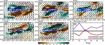
Fig.3.The horizontal patterns of differences in anomalous 850 hPa wind (vector; m s-1) and precipitation (shading; mm d-1)between (a) Phase 2 and 1, (b) Phase 3 and 2, (c) Phase 4 and 3, (d) Phase 5 and 4, and (e) Phase 6 and 5.(f) Phase evolution of 850 hPa meridional wind anomaly averaged in the red and purple boxes shown in Fig.1a.The blue box denotes the YRB region (same as in Fig.1a).
It is speculated that the north-south swing of the rainbelt resulted from the high-frequency wind variability to the north and south of the YRB.For example, a strengthening of the southerly wind anomaly to the south, together with a weakening of the northeasterly anomaly to the north, would push the rainband northward, and vise versa.The strengthening of the southerly wind anomaly is clearly seen in Figs.3a,3c, and 3e.Accompanied by the strengthening of the southerly anomaly was the enhancement of the WNP anticyclone.As the rainbelt moved northward, the anomalous southerly winds appear over the YRB region.The strengthening of the northeasterly anomaly is observed in Figs.3b and 3d.As the rainbelt moved southward, the northeasterly anomaly also shifted southward and appeared over the YRB region.
To quantitatively measure the high-frequency wind variability, we define the following two wind indexes.A southerly index is defined as the average meridional wind anomaly at 850 hPa in the southern box (the purple box shown in Fig.1a).A northerly index is defined as the average meridional wind anomaly at 850 hPa in the northern box (the irregular red box shown in Fig.1a).Figure 3f illustrates the phase evolution of the two wind indexes in the summer of 2020.Both indexes show a clear higher-frequency fluctuation, and the wind change is closely associated with the rainfall fluctuation shown in Fig.2b.
The number of the meridional swings each year during the past 42 years (1979—2020) were examined.It is found that in some years the precipitation anomalies appear scattered and did not move systematically.To quantitatively describe the swings, we counted the number of northward and southward swings from 28°N to 32°N each year.One swing is counted when the precipitation anomaly continues across 30°N from south to north or from north to south.Figure 4 shows the results.While the average number of swings for 1979—2020 is 1.5, the maximum number (5)occurred in 2020.This number is consistent with the six phases shown in Fig.2b.Meanwhile, we also calculated an area-average (28°—32°N, 105°—122°E) precipitation index in June-July to estimate the intensity or duration of the meiyu over the region each year.The correlation coefficient between the precipitation index and the swing number is 0.61, exceeding a 99% confidence level.It implies that the larger the swing number is, the greater the precipitation index is.
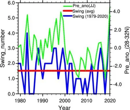
Fig.4.Numbers of northward and southward swings (blue) of the zonal mean precipitation anomaly averaged over 105°—122°E from 28°N to 32°N and the area-averaged (28°—32°N,105°—122°E) precipitation anomaly index (green, mm d—1) in June-July during 1979—2020.The red line represents the average swing number during the period.
To quantitatively measure how strong the higher-frequency rainfall variability in 2020 is in comparison with the climatological counterparts, we calculated the standard deviation of the precipitation anomaly field for the months of June-July over 1979—2019 and 2020 respectively, and the result is displayed in Figs.5a and 5b.For the long-term climatology, a large standard deviation center appears over the YRB region, and the average value in the region is 14.9 mm d.In comparison, the rainfall variability tends to increase over the entire East Asia region in 2020.The maximum increase appears in the green dot region (115°E, 30.25°N), where the standard deviation increases to 32 mm d(twice the climatological value).

Fig.5.The horizontal distributions of standard deviation(shading; mm) of daily precipitation anomaly fields during June-July in (a) the long-term (1979—2019) climatology and(b) 2020.(c) The percentage increase of the precipitation standard deviation in 2020 is relative to climatology.The blue box is the same as in Fig.1a.The green dot indicates the location of maximum rainfall variability in the summer of 2020.
The percentage increase of the rainfall standard deviation is shown in Fig.5c.Over the YRB region, the average increase of the standard deviation in 2020 is about 30%.A maximum increase of 107% appeared in the aforementioned green dot region.Therefore, a prominent feature of the summer of 2020 was a marked increase of high-frequency variability of precipitation over East Asia.
To illustrate the dominant periods of the high-frequency precipitation variability over the YRB, we conducted a power spectrum analysis of daily precipitation for the entire period of 1979—2020.The result shows that there are two separate spectrum bands, with one at the synoptic-scale period (2—10 days) and the other at the intraseasonal period(10—50 days) (Fig.6).Therefore, in the following section,we will decompose the rainfall and circulation fields into the two temporal-scale components and examine physical processes that caused the synoptic (with a period of fewer than 10 days) and subseasonal (10—50 days) variabilities over the region.
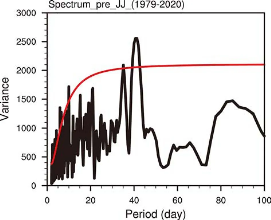
Fig.6.Power spectrum of anomalous precipitation in June-July for the entire period of 1979—2020.Red lines are the threshold of the 95% confidence level.
4.Synoptic and subseasonal variabilities in the summer of 2020
In this section, we intend to reveal special features associated with the synoptic and subseasonal precipitation variability in the summer of 2020 over the YRB region.Figures 7a—c illustrate the zonal distributions of the standard deviation of the daily precipitation anomaly and its synoptic and subseasonal components.Note that in the YRB longitudinal zone (105°—122°E), the rainfall variabilities in 2020 are remarkably larger than those in the long-term climatology in all three panels.The result is consistent with the high-resolution fluctuation of the mei-yu rainband shown in Fig.2b.The intensity of the synoptic variability made a larger contribution to the total rainfall variability compared with the intraseasonal variability.The combined synoptic and subseasonal components explain most of the high-frequency precipitation variability.
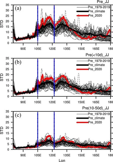
Fig.7.The zonal distributions of the standard deviation (mm) of (a) the daily precipitation anomaly in June-July, (b) its synoptic component, and (c) its subseasonal component averaged from 29.5°N to 31.5°N.Thin black curves denote the standard deviation for the individual years during 1979—2019, and the thick black curve is the long-term (1979—2019)average.Red curves denote the standard deviation in 2020.Blue dashed lines indicate the YRB region.
Figure 8a shows the standard deviation of the synopticscale rainfall variability during the summer of 2020.As expected, a maximum center appears over the YRB region,along with other variability centers in higher latitudes.A pronounced feature of the synoptic-scale variability along the mei-yu front is the eastward propagation of the precipitation and vorticity anomalies.Such a feature is clearly evident in the regressed rainfall pattern (contour of Fig.8b).Here, the regression is done based on a reference point(shown by the green dot in Fig.8a).Compared with the feature of the long-term climatology, the eastward-propagating, synoptic-scale variability appears larger in the summer of 2020 (color of Fig.8b), especially to the west of 118°E.

Fig.8.(a) The horizontal distribution of precipitation standard deviation (shading; mm) on the synoptic-scale in June-July 2020 and (b) the lead-lag regression map of synoptic precipitation anomalies in the long-term climatology(contour; mm d-1) and the difference of the synoptic precipitation anomalies between 2020 and the long-term climatology (shading; mm d-1).The blue box denotes the YRB region.The green dot denotes the location of maximum synoptic variability over the YRB.
The left panel of Fig.9 exhibits the horizontal patterns of the synoptic precipitation and 850 hPa wind fields from day —2 to day +1 derived from the long-term climatology.On day —2, the precipitation anomaly is weak and located in western China near 105°E.Then, the precipitation anomaly is strengthened as it moves eastward along the YRB.It reaches a maximum at day 0 when the precipitation center is located at 115°E.Accompanied by the precipitation anomaly is the low-level cyclonic circulation.The right panel of Fig.9 shows the zonal, vertical cross-section of the regressed vertical velocity, specific humidity, and wind fields from the long-term climatology.Consistent with the eastward propagation of the synoptic-scale rainbelt, the moisture anomaly field (mostly confined to the lower troposphere) also propagates eastward.The moisture anomaly center in the lower troposphere is in phase with the precipitation and the maximum vertical velocity anomaly in the mid-troposphere (Fig.9b).The specific humidity anomaly in the planetary boundary layer (PBL; below 850 hPa), on the other hand, leads the precipitation center, especially between day —2 and day 0.This implies a slightly tilted vertical structure of the moisture field.The zonal wind anomaly is characterized by a first baroclinic mode vertical structure in the free atmosphere, with the maximum westerly (easterly) anomalies at 700 hPa (200 hPa) being in phase with the precipitation center.

Fig.9.The regression maps of horizontal patterns of (a—d) synoptic-scale precipitation (shading; mm d—1) and 850 hPa wind (vector; m s—1) anomaly fields and (e—h) zonal-vertical cross-sections of synoptic-scale vertical velocity (contour; hPa s—1), specific humidity (shading; kg kg—1) and zonal wind (vector; m s—1) anomaly fields averaged over 29.5°—31.5°N from Day —2 to Day +1 in the long-term climatology.The gray shading represents the regions that exceed the 95% confidence level.
Figure 10 illustrates the same horizontal and vertical distributions of the synoptic-scale fields as in Fig.9 but for the summer of 2020.A similar eastward propagation characteristic is observed, but the amplitudes of all the fields are greater than climatology.A notable difference is the lowlevel, wind-precipitation relationship.While a low-level cyclone is in phase with the precipitation center in the climatology (Fig.9c), in the summer of 2020, the precipitation center is in phase with the convergence of northerly winds to its north and southerly winds to its south (Fig.10c).
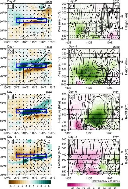
Fig.10.Same as Fig.9 but for June-July 2020.
Next, we examined subseasonal precipitation and circulation variabilities over the YRB.Figure 11 shows the horizontal distribution of the standard deviation of the subseasonal rainfall variability in the summer of 2020.A maximum center is located in the YRB region.To understand the origin of the intraseasonal variability over the YRB, we conducted a regression analysis based on a reference point(a green dot in Fig.11) in the YRB.Figure 12a shows the horizontal patterns of the regressed subseasonal precipitation and low-level wind fields in the long-term climatology from day —8 to day +4.The climatological intraseasonal precipitation anomaly over the YRB is caused by the northwestward propagation of an anomalous anticyclone in the WNP.The center of the anomalous anticyclone is located slightly south of 20°N at day —4 and moves north of 20°N at day 0.Accompanied with the anticyclone is a negative precipitation anomaly.Southerly anomalies to the west of the anticyclone transport warm and moist air northward into the YRB region, leading to enhanced precipitation there.Such a precipitation evolutionary feature is also evident in the anomalous moisture and vertical velocity fields (Fig.12b).

Fig.11.The horizontal distribution of the standard deviation(shading; mm d—1) of the subseasonal precipitation variability in June-July 2020.The blue box denotes the YRB region.The green dot denotes the location of maximum subseasonal variability.
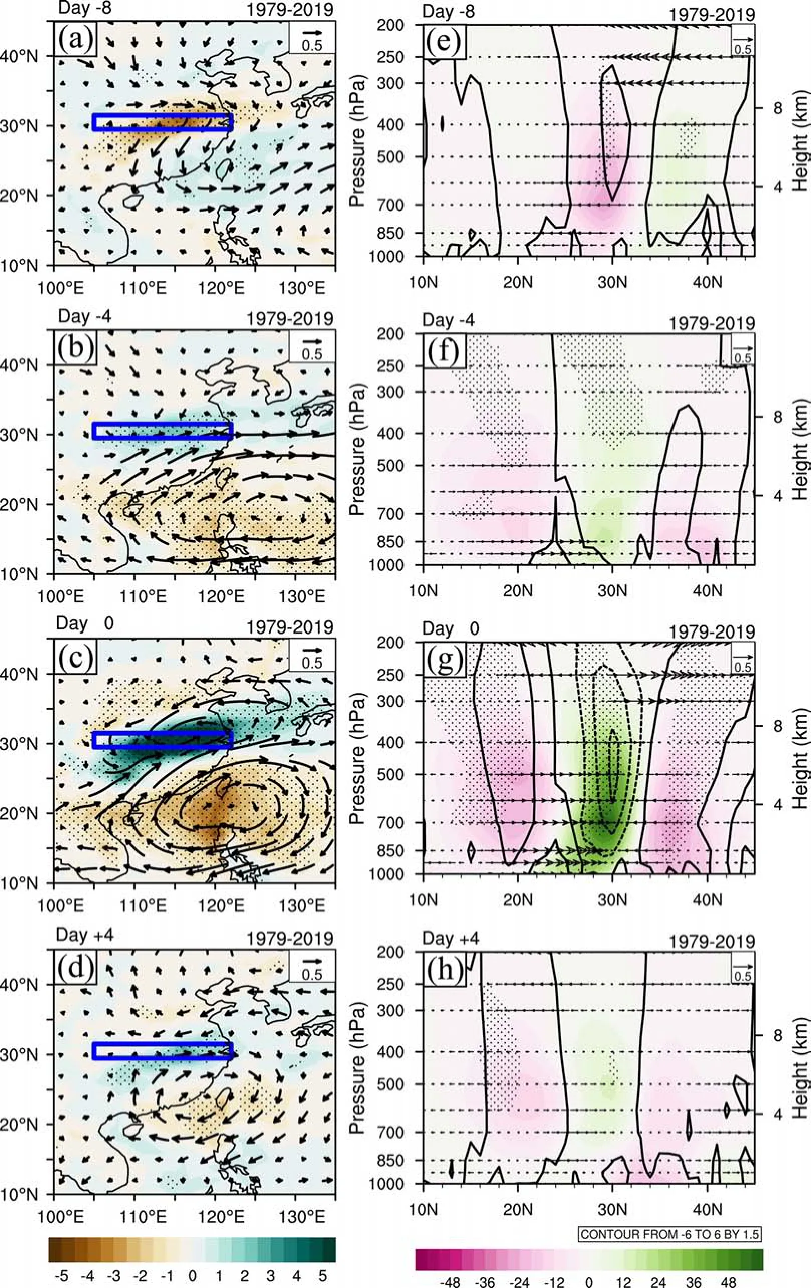
Fig.12.The regression maps of horizontal patterns of (a—d) subseasonal precipitation (shading; mm d-1)and 850 hPa wind anomaly fields (vector; m s—1) and (e—h) zonal-vertical cross sections of subseasonal vertical velocity (contour; hPa s—1), specific humidity (shading; kg kg—1) and zonal wind anomaly fields(vector; m s—1) averaged over 105°—122°E from day —8 to day +4 in the long-term climatology.The gray shading represents the regions that exceed the 95% confidence level.
Figure 13 shows the counterpart fields for the summer of 2020.There is a marked difference between the longterm climatology and the summer of 2020.A cyclonic anomaly with enhanced precipitation was located in the WNP(south of 15°N) at day — 8, while a negative precipitation anomaly appeared in the YRB (Fig.13a).The cyclonic center moved northward and was located near 20°N at day —4(Fig.13b).The cyclonic flow and positive precipitation anomalies continued moving northward and reached the YRB at day 0, causing enhanced rainfall there (Fig.13c).The northward movement is more clearly detectable in the anomalous moisture and vertical velocity fields (Figs.13e—h).
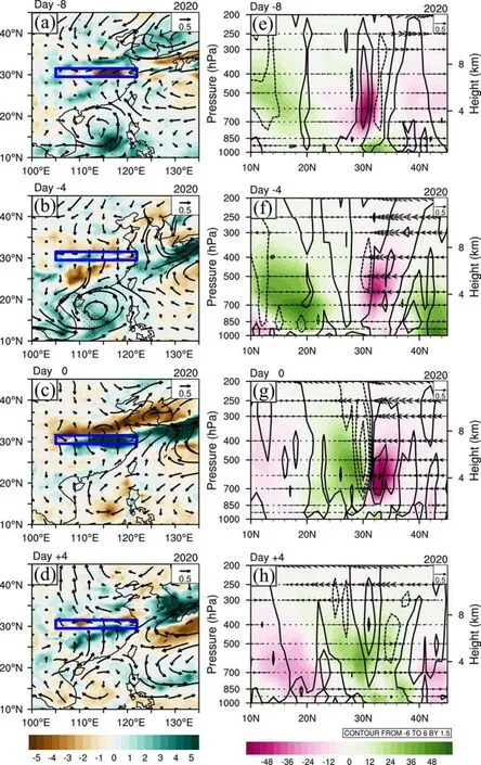
Fig.13.Same as Fig.12 but for the summer of 2020.
To sum up, the YRB in the summer of 2020 experienced exceptionally large synoptic and subseasonal variabilities in the precipitation and wind fields in comparison with the long-term climatology.The temporal evolution of the synoptic variability shows a pronounced eastward propagation, similar to the climatology.The subseasonal rainfall variability in the YRB, on the other hand, differs greatly from the long-term climatology.While a northwestward-propagating anticyclone in the WNP is a dominant precursor signal,a cyclonic anomaly within WNP precedes a positive rainfall anomaly in the YRB.The cyclonic flow continued moving northward from the WNP monsoon trough region all the way to the YRB, leading to strengthened precipitation there.
5.Modulation of synoptic variability by the subseasonal component
It is of interest to diagnose the cause of the high-frequency, north-south swings of the Meiyu rainband in the summer of 2020.As shown in Section 4, the high-frequency variability consists of the subseasonal and synoptic-scale components.In this section, we further link the rainband movement to the two timescale variabilities.
Figure 14 shows the meridional-time cross sections of the zonal-mean precipitation anomaly averaged over 105°—122°E and the corresponding synoptic and subseasonal components in June-July 2020.Figure 14a is essentially the same as that shown in Fig.2b, except the summer mean anomaly is removed.The six extreme phases shown in Fig.2b are well-reflected in Figure 14a.It is also interesting to note that the patterns shown in Figs.14b and 14c closely resemble Fig.14a.To quantitatively measure the similarity, a pattern correlation analysis is applied.The result shows that the correlation coefficient between Figs.14a and 14b is 0.7, whereas the correlation coefficient between Figs.14a and 14c is 0.6.Both of the pattern correlations exceed the 99% confidence level.

Fig.14.(a) Latitude-time section of the zonal-mean(105°—122°E) precipitation anomaly (shading; mm d-1) during June-July 2020.(b—c) Same as (a) but for the synoptic and subseasonal components.
The significant pattern correlations between the daily anomaly pattern and those from the synoptic and subseasonal components imply that the north-south swing of the zonal-mean rainband was likely attributed to the combined impacts of the synoptic and subseasonal variability over the mei-yu frontal region.Thus, it is important to predict the synoptic and subseasonal variabilities in the mei-yu precipitation region in addition to forecasting the seasonal mean anomaly.
An important feature implied from Fig.14 is the modulation of the strength of the synoptic-scale variability by the intraseasonal component.Note that maximum synoptic variabilities often occur in the region where the subseasonal rainfall is strengthened.For example, in Phase 1, maximum synoptic variability appears to the south of 30°N, while in Phase 2 it shifts north of 30°N.Physically, it is argued that the subseasonal rainfall variability can modulate the higherfrequency synoptic variability through the modulation of the background moisture and vorticity fields (Zhou and Li,2010).A greater background moisture field (due to upward transport of the mean moisture) is favorable for the enhanced development of synoptic-scale motions (e.g., Li and Zhou, 2013; Crosbie and Serra, 2014; Lee et al., 2018;Zhao and Li, 2019).
The in-phase relationship between the intensity of the synoptic-scale variability and the subseasonal mode is further demonstrated in Fig.15.The top panel of Fig.15 shows the latitudinal distributions of the degree of the synoptic-scale variability from Phase 1 to Phase 6.Here the synoptic-scale variability intensity is measured by its standard deviation in a 5-day running window.Note that maximum synoptic variability centers (filled circles in Fig.15a) shift back and forth, closely following the location of the maximum subseasonal rainbelt.

Fig.15.(a) Evolution of a latitudinal profile of the synopticscale precipitation standard deviation (mm) from Phase 1 to Phase 6 and (b) latitude-time section of standard deviation(shading; mm) of the synoptic-scale precipitation anomaly calculated based on a 5-day running window in June-July 2020.The filled circles in (a) denote the locations of the maximum standard deviation center for each phase.
The lower panel of Fig.15 illustrates the latitude-time cross section of the so-calculated synoptic-scale variability intensity as in Fig.15a.While the standard deviation is always positive, the maximum centers consistently follow the subseasonal rainfall maximum shown in Fig.14c.The pattern correlation coefficient between Fig.15b and Fig.14c is 0.5, which is significant at the 99% confidence level.
The strong modulation of the ISO on synoptic variability was pointed out by several previous studies (e.g., Zhou and Li, 2010; Hsu et al., 2011; Zhu et al., 2019).However,most of these previous works focused on the WNP and Maritime continent regions.In this study, we show observational evidence (e.g., Fig.15), over the subtropical mei-yu front region, that the intensity of the synoptic variability is greatly modulated by the ISO.Strong synoptic rainfall variability tends to occur in the region of the maximum intraseasonal rainbelt.Physically, we argue that the ISO may affect the synoptic activity through the modulation of the background moisture and vertical motion fields.
The background summer mean state over the region of interest is generally convectively unstable.During the active phase of the ISO, the background condition contains more moisture, and with stronger ascending motion the atmosphere becomes more convectively unstable.Given the same initial synoptic perturbation, the perturbation would grow faster under the active ISO phase than the inactive ISO phase.The favorable background moisture condition during the active phase of the ISO would induce positive feedback between synoptic-scale heating and circulation.On the one hand, an enhanced heating anomaly due to the favorable background moisture condition would induce stronger synoptic wind activities; on the other hand, the enhanced winds would further strengthen the heating.The increase in the background moisture field under an active ISO phase is a result of enhanced ascending motion (via vertical moisture advection) associated with the subseasonal rainfall variability.Given the strong modulation of the synoptic-scale activity by the subseasonal rainbelt variation, we conclude that the observed meridional swing of the mei-yu rainband in 2020 (shown in Fig.2b) was ultimately controlled by the subseasonal rainfall variability.
6.Conclusion and discussion
While the climatological mei-yu rainbelt moves steadily across the Yangtze River basin (YRB), the mei-yu rainbelt experienced multiple northward and southward swings in June-July 2020.Accompanied by the meridional swings of the rainbelt was a change in the strength of southerly wind anomalies to the south, associated with an anomalous anticyclone in the tropical western North Pacific, and a change in the northeasterly wind anomalies to the north, associated with an anomalous anticyclone in Northeast Asia.It was the alternating strengthening and weakening of the two opposing anomalous flows that led to the north-south swings of the mei-yu rainband over the YRB.
In addition to the exceptionally strong seasonal mean precipitation, daily rainfall in the summer of 2020 experienced stronger than normal high-frequency variability over the YRB.The calculation of the standard deviation of daily precipitation shows that the largest variability was centered over the YRB in June-July 2020, while climatologically the maximum variability center is typically located in Taiwan and the western Pacific.Maximum rainfall variability in the YRB region in the summer of 2020 increased by 80%.
By decomposing the daily precipitation field into a synoptic-scale (with a period of less than 10 days) and a subseasonal (with a period of 10—50 days) component, we can further examine the relative contribution of the two components.It is found that while both the components are remarkably enhanced in the summer of 2020, the strengthening of synoptic-scale variability appears to be greater over the YRB.The cause of the stronger synoptic and subseasonal variabilities is likely attributed to the increase of the background mean moisture field due to the exceptionally strong seasonal mean precipitation and ascending motion.
Consistent with this climatological feature, the synoptic-scale component along the mei-yu front in the summer of 2020 exhibits a clear eastward propagation.Associated with the maximum precipitation is the low-level cyclone, oriented in a northeast-southwest direction.The zonal-vertical structure of the specific humidity and vertical velocity fields show an in-phase relationship with the precipitation anomaly, propagating eastward along the mei-yu front.The zonal wind field, on the other hand, shows a first baroclinic mode structure over the rainfall center, with maximum westerly(easterly) winds being located in the lower (upper) troposphere.
The evolutionary feature of the subseasonal variability appears markedly different in the summer of 2020 compared with the long-term climatology.Climatologically, an enhanced subseasonal rainfall in the YRB is preceded by an anomalous anticyclone in the WNP.With the northwestward progression of the anticyclone, southerly anomalies to the west of the anticyclone advect wetter and warmer air into the YRB region, leading to a positive rainfall anomaly.The subseasonal variability in the summer of 2020 appeared quite different.A low-level cyclonic anomaly in the WNP preceded the variability, and the anomalous cyclone continued moving northward into the YRB, leading to enhanced precipitation there.The northward movement of the subseasonal system is also detected from the moisture and vertical velocity fields.
It is found that the synoptic and subseasonal precipitation components have a similar meridional-time evolution pattern, both of which resemble the total precipitation anomaly field (Fig.14).This implies that the meridional swings of the mei-yu rainbelt in the summer of 2020 resulted from the combined effect of the synoptic and subseasonal variabilities.It is further noted that the strength of the synoptic-scale variability was greatly modulated by the subseasonal rainfall variation, that is, the maximum synoptic-scale rainfall variability appeared in the region where the subseasonal rainfall anomaly is positive.Such a strong subseasonal modulation of the synoptic variability implies that the meridional swings of the mei-yu rainbelt are essentially controlled by the subseasonal mode.
It is worth mentioning that the meridional swing of the mei-yu rainband also happened in other years.For example,summer precipitation in 1983 exhibited clear northward and southward swings, and the mei-yu rainbelt moved back and forth several times during June and July of 1983 while the mean locations of the rainfall center were located in the Yangtze River basin.A further examination of the spatiotemporal structures of rainfall in 1983 revealed that while the synoptic-scale precipitation and wind fields had pronounced eastward propagation, the subseasonal precipitation and wind fields were dominated by northward propagation, which originated from the tropical WNP.Again there was a clear ISO modulation of the synoptic variability in 1983 over the YRB region.
Given the important role of the synoptic and subseasonal modes in affecting the meridional swings of the mei-yu rainbelt, it is conceivable that accurately predicting the higher-frequency modes is critical in improving the extended-range forecast of extreme weather events.The current finding of the close linkage between the strength of the synoptic variability and the phase of the subseasonal mode may provide an additional avenue for predicting the statistical behavior of strength of the synoptic variability.In other words, by using the observed statistical relationship between the ISO phase and the probability of the extreme synoptic events, one may provide forecast outlooks for potential extreme weather events.To further understand the scale interaction between the synoptic and subseasonal variability, it is desirable to conduct idealized numerical model experiments, which will be done in future endeavors.
Acknowledgements.This work was jointly supported by China National Key R&D Program 2018YFA0605604, NSFC grants (Grant No.42088101, 41875069), NSF AGS-2006553, and NOAA NA18OAR4310298.This is SOEST contribution number 11413, IPRC contribution number 1541, and ESMC number 357.
杂志排行
Advances in Atmospheric Sciences的其它文章
- The Seasonal Prediction of the Exceptional Yangtze River Rainfall in Summer 2020※
- Electronic Supplementary Material to:The Anomalous Mei-yu Rainfall of Summer 2020 from a Circulation Clustering Perspective: Current and Possible Future Prevalence*
- The Extreme Mei-yu Season in 2020: Role of the Madden-Julian Oscillation and the Cooperative Influence of the Pacific and Indian Oceans※
- The Record-breaking Mei-yu in 2020 and Associated Atmospheric Circulation and Tropical SST Anomalies※
- Cause of Extreme Heavy and Persistent Rainfall over Yangtze River in Summer 2020※
- The Anomalous Mei-yu Rainfall of Summer 2020 from a Circulation Clustering Perspective: Current and Possible Future Prevalence※
