Regional Differences and Optimal Allocation of Cultivated Land Utilization Benefits Based on Improved TOPSIS Method: A Case Study of Guangxi
2021-09-24ChuchuSUNNingGENGMengyaoWANG
Chuchu SUN, Ning GENG, Mengyao WANG
School of Public Administration, Shandong Normal University, Jinan 250014, China
Abstract Taking 14 prefecture-level cities in Guangxi as an object, this paper explored the difference of cultivated land utilization efficiency in Guangxi, comprehensively evaluated the economic, social, and ecological aspects, and analyzed the regional differences in cultivated land use efficiency in Guangxi from 2005 to 2018 based on the improved TOPSIS method. By studying the quantitative change trends and spatial differences of the utilization benefit of cultivated land resources in Guangxi, it came up with recommendations for optimizing the allocation of cultivated land from the quantity and quality of cultivated land. It is intended to provide a scientific and theoretical reference for improving the use efficiency of cultivated land in Guangxi.
Key words Efficiency of cultivated land use, Improved TOPSIS method, Regional difference, Optimal allocation, Guangxi
1 Introduction
Cultivated land, as a vital place for human beings’ agricultural production, is the rarest land resource and a solid foundation for guaranteeing the social and economic development of a country. On the one hand, the rational use of cultivated land is crucial to the healthy development of the ecological environment; on the other hand, it concerns the sustainable development of the economy and society. While maintaining the quantity of cultivated land, the quality of cultivated land is even more significant. In the course of social development, the destruction and abuse of cultivated land result in the loss of high-quality cultivated land and the decline of its quality. In accordance with theNational
Land
Plan
(2016-2030
), we must adhere to the "three-in-one" protection strategy of cultivated land, adjust the agricultural planting structure, and strengthen the protection of basic farmland. The benefits of cultivated land use can embody the level of sustainable use of cultivated land, and can provide a significant reference for safeguarding food production and transforming land management model. The research on the comprehensive benefits of cultivated land use mainly focuses on the following aspects. The first is utilization benefits. Using indicators such as output benefits of cultivated land, consumption returns, pollution substitution, intensification of farmland use,etc.
, it is able to measure and calculate the farmland use efficiency. Accordingly, it can draw a conclusion that the improvement of efficiency of farmland use is related to economies of scale, the increased government’s investment in agricultural scientific research, and the increased investment in rural education. The second is the measurement and calculation of comprehensive economic, social and ecological benefits. Through establishing a coordination degree model and the use of entropy weight method, Zhang Wenqiet
al.
made a quantitative evaluation of the coordination degree of the cultivated land use benefit system in Harbin of Heilongjiang Province; scholars have carried out many practices selecting multinomial factors from provinces and cities, fully studied and evaluated the change characteristics and regional differences of impact factors, and used the entropy method to evaluate and calculate the cultivated land in the calculated area, then used the measured values of economic, social, ecological benefits to study spatial characteristics.Regarding the research on the method of optimal allocation of cultivated land, it mainly focuses on the following two kinds: one is to use different methods such as linear programming, system dynamics, particle swarm algorithm to optimize the coupling quantity of regional land use results. In addition, simulated annealing and multifunctional genetic algorithm are used to solve the optimization problem of spatial layout. The other is to improve the ant colony algorithm. On this basis, it is coupled with GIS to establish a multi-objective ant colony algorithm. Based on this model, we optimized the configuration of land use, to realize the application of the model in a real world scenario. Compared with traditional methods, the superiority of multi-objective ant colony algorithm in the optimal allocation of land use was obtained.
2 Overview of the study area
Guangxi Zhuang Autonomous Region is located in low latitudes, with subtropical monsoon climate and tropical monsoon climate; the climate is warm, with plenty of light, and the average annual precipitation is 841-3 388 mm. More than 986 rivers in Guangxi collect more than 50 kmof rain water, with a total length of 34 000 km, and the density of the rivers is 144 m/km. Soil types include brick red soil, latosolic red soil, yellow soil, lime (rock) soil, and coastal saline soil. At the end of 2018, the region’s GDP was 2 035.3 billion yuan, 6.8% over the previous year. The primary industry grew by 5.6%, the secondary industry grew by 4.3%, and the tertiary industry grew by 9.4%. According to the permanent population, the annual per capita GDP was 41 489 yuan, an increase of 5.8% over last year. By the end of 2018, the area of cultivated land in Guangxi was 4.388 4 million ha, of which 2.429 1 million ha is dry land, accounting for 55.35% of the cultivated land area.
3 Data source and evaluation method
3.1 Data source
The data in this study were selected fromGuangxi
Statistical
Yearbook
, China Statistics Information Network, Chinese Academy of Sciences Resource and Environmental Science Data Center, EPS Global Statistics/Analysis Platform, official website data, government work reports,etc.
3.2 Evaluation method of cultivated land utilization benefit
3.2.1
Selection and description of the evaluation indicator system for cultivated land utilization. The evaluation of cultivated land utilization benefit needs to be coupled with economic, social and ecological aspects. We integrated three criteria of independence and representativeness, operability and comparability, and the integration of economic, social and ecological benefits, combined with the characteristics of cultivated land use in Guangxi. With reference to the results of relevant scholars, we established the target layer, namely, the benefit of cultivated land, and the three criterion levels are economic benefit, social benefit and ecological benefit. We selected 14 evaluation factors from economic, social and ecological factors to form the index layer, and established a comprehensive indicator system for evaluating the benefit of cultivated land use in Guangxi.
Then, we determined the indicator weight:
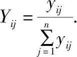

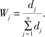
(iv) Using the entropy weight method, we calculated the weight of each indicator, as shown in Table 2.
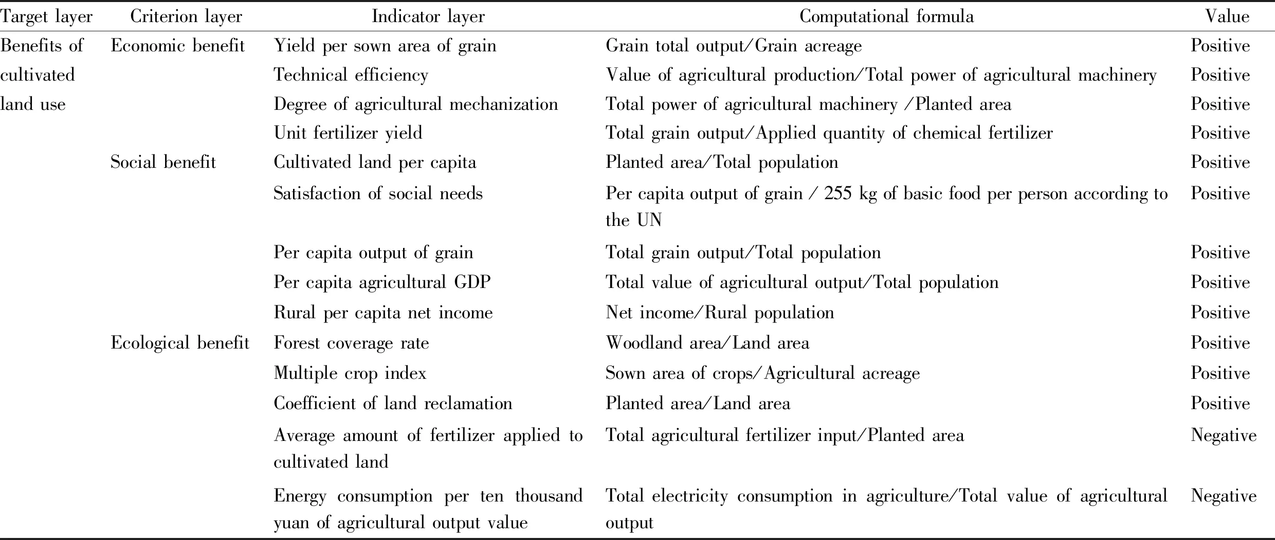
Table 1 Cultivated land use benefit evaluation indicator system
3.3 Improved TOPSIS Method
The specific algorithm steps of the improved TOPSIS method are as follows:(i) The canonical decision matrixb
is obtained by vector normalization method (that is, the normalized matrixy
in the entropy weight method).(ii) Form a weighted gauge matrixC
=(c
)×. Assume that the weight vector of each attribute given by the decision-maker is the weight of each indicator calculated in the entropy weight method, and isw
=[w
,w
, …,w
], thenc
=w
·b
,i
=1, 2, …,m
;j
=1, 2, …,n
.
(iv) Calculate the distance from each scheme to positive and negative ideal solutions.


(v) Calculate the queuing index values of each scheme (that is the comprehensive evaluation index)


4 Evaluation result of cultivated land use benefit
4.1 Economic benefit evaluation results
The scores and rankings of the economic benefits of cultivated land use in the 14 cities from 2005 to 2018: the top two in 2005 were: Hezhou City > Wuzhou City, and the second two were: Laibin City > Chongzuo City; the top two in 2018 were: Hezhou City > Wuzhou City, and the bottom two were: Hechi City > Chongzuo City. The average economic benefits of cultivated land use in 2005, 2010, 2015 and 2018 were 0.759 8, 0.771 8, 0.815 2, and 0.835 5, respectively. On the whole, the economic benefits of cultivated land use were on the rise (Table 3).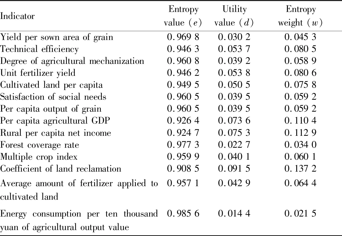
Table 2 Indicator weight
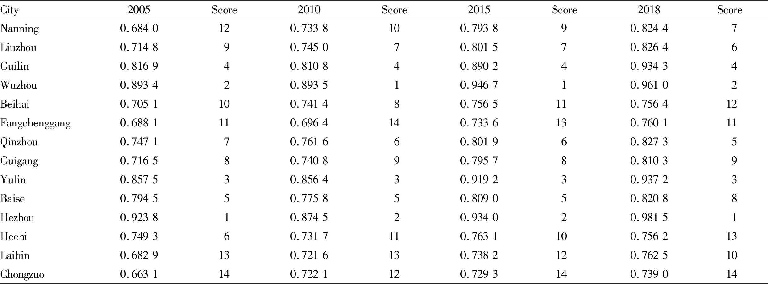
Table 3 Evaluation value of economic benefits of 14 cities in Guangxi from 2005 to 2018
4.2 Social benefit evaluation results
The scores and rankings of the social benefits of cultivated land use in the 14 cities from 2005 to 2018: the top two cities in 2005 were: Chongzuo City > Laibin City, and the second two were: Liuzhou City > Wuzhou City. In 2018, the top two rankings were: Guilin City > Chongzuo City, and the bottom two were: Wuzhou City > Hechi City. The average values of the social benefits of cultivated land use in 2005, 2010, 2015 and 2018 were 0.675 0, 0.714 6, 0.801 8, and 0.860 1, respectively. The social benefits of cultivated land use in each city were on the rise (Table 4).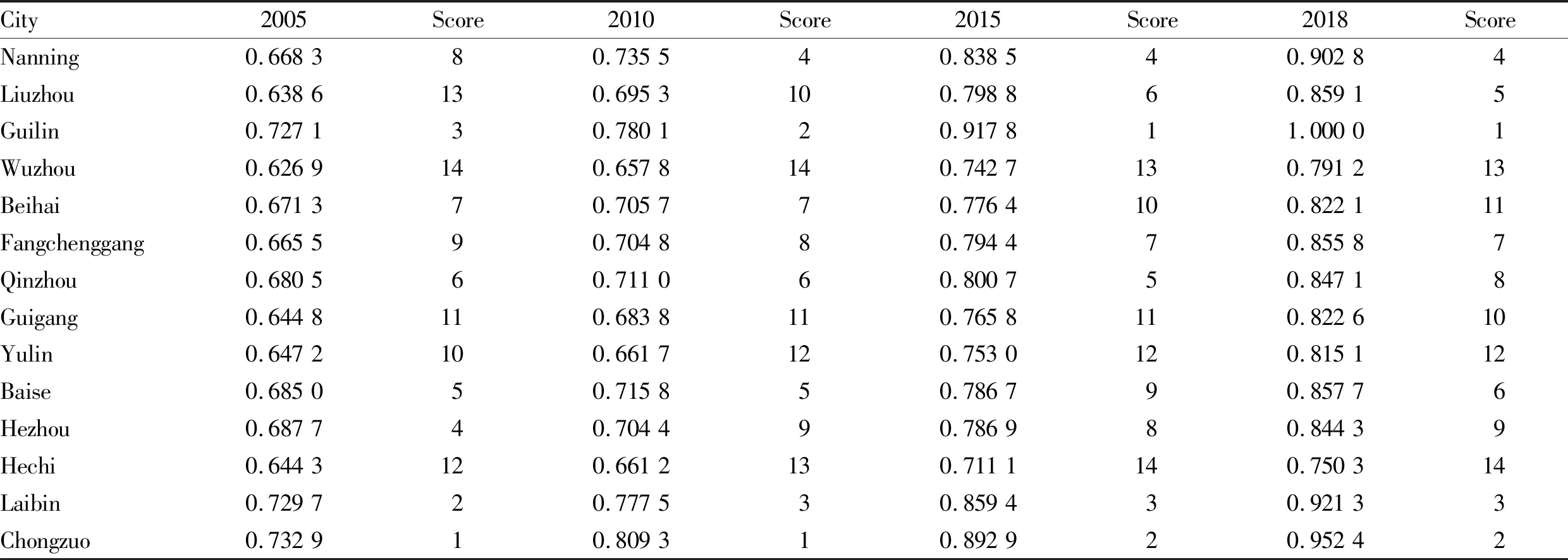
Table 4 Evaluation value of social benefits of 14 cities in Guangxi from 2005 to 2018
4.3 Ecological benefit evaluation results
The scores and rankings of the ecological benefits of cultivated land use in 14 cities from 2005 to 2018. The top two cities in 2005 were: Beihai City > Guigang City, and the bottom two were: Hechi City > Fangchenggang City. By 2018, the top two rankings were Beihai City > Guigang City, and the bottom two rankings were Hechi City > Fangchenggang City. The average values of the ecological benefits of cultivated land use in 2005, 2010, 2015 and 2018 were 0.735 8, 0.718 1, 0.717 7, 0.711 6, respectively. The ecological benefits of cultivated land use in each city showed a trend of overall decline, but the range was small (Table 5).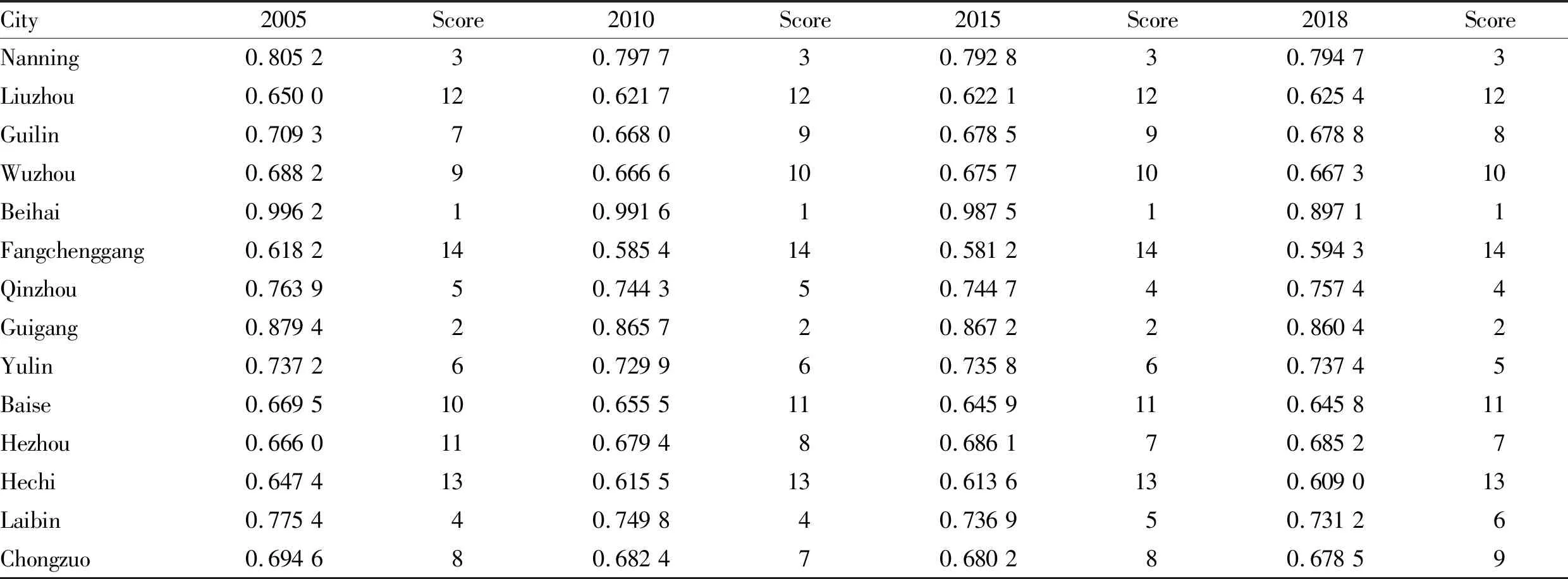
Table 5 Evaluation value of ecological benefits of 14 cities in Guangxi from 2005 to 2018
5 Analysis of regional differences in cultivated land utilization benefits in Guangxi
5.1 Analysis of time changes in cultivated land utilization benefits regional differences
Due to the different policies of each city, the quality and utilization of cultivated land are also different. We studied the difference in time of cultivated land use benefits to better understand and study the characteristics of cultivated land use benefits in each city.5.1.1
Time change analysis of regional differences in economic benefits. From Fig.1, we can see that from 2005 to 2018, the economic benefits of cultivated land use in 14 cities have been on the rise.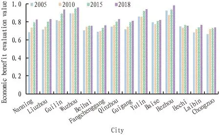
Fig.1 Time change of economical benefit of cultivated land use in 14 cities in Guangxi
The specific performance is as follows: the increase from 2005 to 2010 was smaller than the increase from 2010 to 2015, with the largest increase from 2005 to 2010. the increase in 2015-2018 was smaller than that in 2005-2010, showing a slight increase or maintaining a relatively stable state. The highest point of the economic benefit evaluation value of cultivated land utilization was 0.981 5 in Hezhou City in 2018, reaching the best point.
5.1.2
Time change analysis of regional differences in social benefits. As can be seen from Fig.2, the social benefits of cultivated land use in the 14 prefecture-level cities in Guangxi from 2005 to 2018 showed an overall upward trend, and the upward trend was roughly the same, mainly as follows: 2005- In 2010, the social benefit increased slightly, and the increase in 2010-2015 was larger than the increase in the previous five years. In 2015-2018, there was a small increase but the increase was slightly larger than the increase in 2005-2010. The highest point of social benefit of cultivated land utilization was 1 in Guilin City in 2018, reaching the best.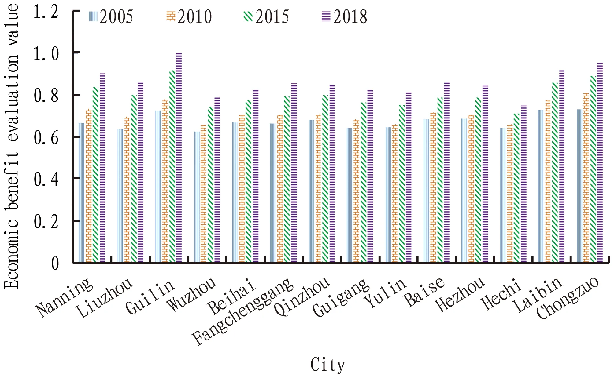
Fig.2 Time change of social benefit of cultivated land use in 14 cities in Guangxi
5.1.3
Time change analysis of regional differences in ecological benefits. From Fig.3, it can be seen that the regional changes trend of ecological benefits of cultivated land use were gentle, and it was in a state of slow decline overall. Most of the 14 cities are in 2005, the ecological benefit score was relatively high, and not much different from 2018. The ecological benefit score of Beihai was the highest, which may be due to the high land reclamation coefficient of Beihai. The ecological benefit of cultivated land use in Fangchenggang was the lowest, which might be due to the larger average amount of fertilizer applied to cultivated land and the larger consumption of agricultural output value of ten thousand yuan.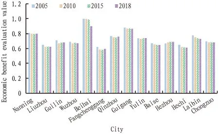
Fig.3 Time changes of ecological benefit of cultivated land use in 14 cities in Guangxi
5.2 Analysis of spatial changes of regional differences in cultivated land use benefits
Using ARCGIS spatial analysis technology and the natural breakpoint classification method, we classified the four research periods in 2005, 2010, 2015, and 2018. The point divided the scores of social, economic, and ecological benefits of cultivated land use in 14 cities into three sections to compare and analyze the regional differences of cultivated land use benefits in Guangxi.Among them: dark red is recorded as high value area, peach red is recorded as medium value area, and light pink is recorded as low value area.
5.2.1
Analysis of spatial change of regional difference of economic benefit. As can be seen from Fig. 4A-D, the economic benefit scores of cultivated land use in 2018 are ranked in order of magnitude. Among them, the high-value areas are: Guilin, Yulin, Wuzhou, and Hezhou; the middle-value areas are: Baise, Liuzhou, Nanning, Qinzhou, Guigang; the low-value areas are: Beihai, Fangchenggang, Laibin, Chongzuo, Hechi. The average score of economic benefit in 2018 was 0.835 5, the highest score was 0.981 5 in Hezhou, and the lowest score was 0.739 in Chongzuo, a difference of 0.242 5. Comparing the spatial differentiation map of the economic benefits of cultivated land use in 14 cities in Guangxi from 2005 to 2018, it can be seen that the segmented value of the economic benefits of cultivated land use is increasing every year. The data shows that the regional characteristics of its economic benefits are obvious, and the economic benefits of cultivated land use in each city have large differences.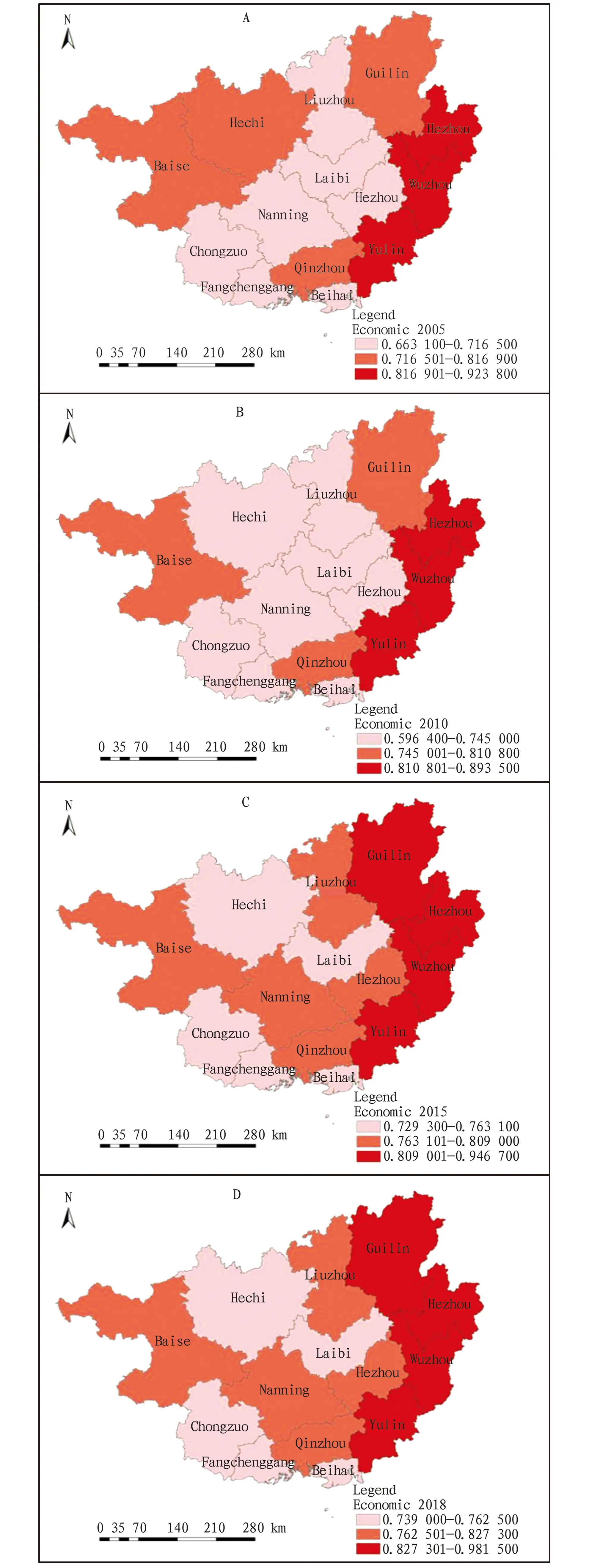
Fig.4 Divergence of economic performance in 2005, 2010, 2015, 2018
5.2.2
Analysis of spatial change of regional difference of social benefit. From Fig.5A-D, it can be seen that in 2018, the 14 prefecture-level cities in Guangxi’s social benefit scores of cultivated land use are ranked in order of magnitude. Among them, the high-value areas are: Guilin, Laibin, Nanning and Chongzuo, and the middle-value areas are: Liuzhou, Fangchenggang, Qinzhou, Baise, Hezhou, Beihai, Guigang and Yulin. The low-value areas are: Wuzhou and Hechi. Comparing the spatial differentiation map of the social benefits of cultivated land use in 14 cities from 2005 to 2018, it can be seen that the segmented value of the social benefits of cultivated land use is increasing every year. The average score of social benefits in 2018 was 0.860 1, the highest score was 1 in Guilin, and the lowest score was 0.750 3 in Hechi, a difference of 0.249 7. The data shows that the regional characteristics of its social benefits are obvious, and the social benefits of cultivated land use in each city have large differences.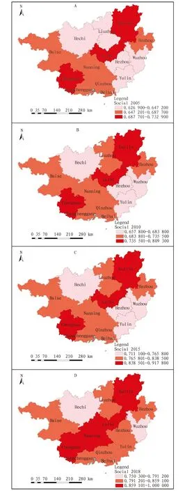
Fig.5 Divergence of social performance in 2005, 2010, 2015, 2018
5.2.3
Analysis of spatial change of regional difference of ecological benefit. From Fig.6A-D, it can be seen that the ecological benefit scores of cultivated land use in 2018 are ranked in order of magnitude. Among them, the high-value areas are: Nanning, Beihai and Guigang. Located in the middle value area are: Guilin, Hezhou, Laibin, Wuzhou, Yulin, Qinzhou and Chongzuo. Located in low-value areas are: Liuzhou, Fangchenggang, Baise and Hechi. Comparing the spatial differentiation map of the ecological benefits of cultivated land use in 14 cities in Guangxi from 2005 to 2018 shows that the segmented value of ecological benefits of cultivated land use is declining every year. In 2018, the average score of ecological benefits was 0.711 6, the highest score was 0.860 4 in Guigang, and the lowest score was 0.594 3 in Fangchenggang, a difference of 0.266 1. The data shows that the regional characteristics of its ecological benefits are obvious, and the ecological benefits of cultivated land use in each city are quite different.
Fig.6 Divergence of ecological performance in 2005, 2010, 2015, 2018
6 Recommendations
In terms of optimizing the amount of cultivated land use, it is recommended to integrate the fragmented land and continue to tap the potential of cultivated land. Guangxi is located in the southern part of China. Its topography is complex and diverse, and the complete land can be divided into scattered land by hills. Therefore, it is necessary to integrate scattered cultivated land, sort out the scattered features, field trails, abandoned cultivated land and other related information, and filter out good quality. The cultivated land in the 14 cities will be integrated using technical methods to increase the area of cultivated land and expand the per capita cultivated land area of 14 cities. At the same time, it is necessary to make plan for the development of cultivated land in detail and protect the reserve resources of cultivated land. Taking theGeneral
Plan
for
National
Land
Use
andLand
Consolidation
Plan
as the prerequisite, guided by the spatial planning of 14 cities, and required by the urban master plan and major functional zone planning, every city must further prepare more detailed special plans for the macro control of development, arrangement, and reclamation of reserve resources of cultivated land in accordance with planning requirements and standards. The implementation should be targeted and feasible. Strict management and control of cultivated land reserve resources must be carried out to realize the sustainable use of cultivated land reserve resources.In terms of optimizing the quality of cultivated land use, using organic fertilizer can increase the production potential of cultivated land. Traditional pesticides and chemical fertilizers have great damage to cultivated land, which not only causes environmental pollution and increases the pressure on the ecological environment, but also reduces soil quality and reduces the productivity of cultivated land; however, organic fertilizers increase the productivity of cultivated land while maintaining the fertility of cultivated land. Therefore, it is recommended to vigorously promote organic fertilizer. Relevant departments and organizations should provide channels for farmers purchasing organic fertilizers, provide agricultural subsidies to them, and reduce the price of organic fertilizers. It is recommended to train farmers to use organic fertilizers scientifically and correctly, which will not only protect the environment, but also reduce the acidification of the soil, increase the output, and protect the ecology and the cultivated land. In addition, it is necessary to improve the construction of agricultural infrastructure, improve the level of mechanization, and strengthen the construction of agricultural infrastructure.
The government should increase subsidized investment in agricultural infrastructure. When promoting the government’s special financial funds, agricultural technology departments should actively stimulate farmers’ enthusiasm for production, provide training to farmers in areas that are of interest, and improve the level of local agricultural mechanization. Besides, it is recommended to establish and improve the monitoring system of cultivated land use, to promptly know the cultivated land use. Finally, it is recommended to take advantage of remote sensing (RS), geographic information systems (GIS), and global positioning systems (GPS) technologies (collectively referred to as “3S” technologies) to monitor the cultivated land use, train relevant technical and management personnel to form a professional team, ensure the accuracy and current situation of basic cultivated land use data, and grasp the cultivated land use changes in real time, so as to improve the proper and scientific use and management of cultivated land.
杂志排行
Asian Agricultural Research的其它文章
- Efficiency Comparison and Influencing Factor Analysis of Dairy Farms over/at Different Scales: Based on the Survey Data of 263 Scale Farms in 22 Provinces of China
- Characteristics of Fallen Seed Distribution by Domestic and Imported Aerial Seeding Equipment
- Thoughts on Present Situation of Development of Rural Animal Husbandry and Its Relationship with Construction of Ecological Agriculture and Revitalization of Rural Industry
- Implementation Path and Development Trend of Green Buildings Based on Life Cycle Management
- Hot Spot Analysis and Development Trend of Intelligent Roof Parking Lot: Bibliometric Analysis Based on CiteSpace Visualization Software
- Biological Evaluation of Water Quality for Benthos in Typical Rivers of Eastern Jilin Province
