Early glaciological and Quaternary Geology cooperation
2021-08-19HarryZILLIACUS
Harry ZILLIACUS
University of Helsinki Faculty of Science, Finland
Abstract The article depicts the author’s experiences of Glaciology and Quaternary Geology research between Finland and the People’s Republic of China. The focus is on a visit to a glaciological station in Tianshan in 1988. The climate is continental displaying warming-up and increased precipitation since the end of the 1980’s. The data collected here is of utmost importance when analysing the future development of the glaciers. Some associations to the historic Silk Roads are made having implications on the Belt and Road strategy launched by the Chinese. As to problems of sea and lake ice, Finland and the P. R. China have found issues of mutual interest resulting in continuing cooperation in the Arctic and in ice-covered areas of China. New forms of bilateral collaboration such as university education and training have evolved encompassing coming generations.
Keywords glaciers, geomorphology, Tianshan, climate change, the Belt and Road
1 Introduction
A glaciological station and an ice camp were established in the Tianshan Mountains in northwestern China in 1959 as a base for sustainable fieldwork. In this area southwest of the regional capital Urumqi, there is a large number of alpine glaciers affecting the water management of the population of the altitudinal strips between the Taklamakan and Junggar deserts in the south and in the north. The geographical settings in the area are very different from those of Finland.
As a young post-doc researcher I got the opportunity to visit the People’s Republic of China. Personally, this developed into a rewarding experience ending up in fields such as Glaciology, Quaternary Geology and Geomorphology, later also within applied environmental research and research & educational work across many sectors.
2 Visiting China in 1988 for glacier studies
The initial visit to China, its northern parts at the Yellow River (Huanghe) and the mountain chains of Central Asia and their glaciers, was carried out in 1988. The Academy of Finland and Chinese Academy of Sciences decided to exchange researchers in Natural Science. For me, this evolved into a life-long interest into China affairs of all kinds. Later this led to support for additional trips and to fieldwork with Chinese colleagues, in addition to teaching and lecturing in various parts of the country.
At the end of the 1980’s, I often felt that I was the first Finnish guest to visit these research institutes and universities. Firstly, the Finns had to be placed somewhere between the Soviet Union/Russia and Sweden before we could really talk business. For geographers, this was usually quite easily done, and it was noted that our country was among the first to officially acknowledge the People’s Republic of China and thereby to establish diplomatic relationships with her.
This was a good foundation for future cooperational work between Finland and China. And to be quite honest,my knowledge of China was perhaps even more limited than that of my students about Finland, as I sat on the west-bound train from Beijing on my way to the 9000 Tianshan glaciers and ice camp some 3600 m a.s.l. I then visited the same spot some 15 years later and could e.g.note how the warming climate was in the process of eagerly consuming large volumes of the glaciers.
Calculating the number of glaciers in a certain area might be a misleading criterion, though: Glacier nr 1 (43°N,86°E) was early on ramified in two parts, but split up in 1993 in two entirely separate glaciers as a result of the rapid recession of the ice margin (Figures 1-2). The absolute number of separate ice masses may thus increase as the total volume decreases. It has to be noted that the Tianshan glaciers are relatively small and, as a consequence, may disappear fairly quickly.
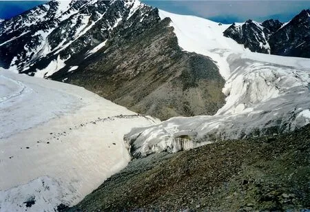
Figure 1 Glacier nr 1 (June 1988), the main objective of research at the station. Western branch (right) still connected to eastern branch(left). A tunnel was dug at 3850 m a.s.l. into the western ice tongue but collapsed at this point due to recession of the ice margin.
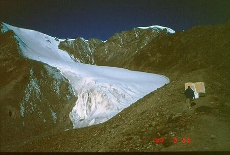
Figure 2 Glacier nr 1 (Sept 2003), western branch clearly separated from eastern branch since 1993. Glaciers 2-5 on other sides of the Urumqi River headwaters were all in a phase of recession.
For local people on both sides of the mountain range the melt-waters mean everything for irrigation in the narrow altitudinal zones between the subalpine zone and the extremely dry Taklamakan and Junggar Deserts on the south and north sides, respectively. In the Shenglidaban Pass at 4010 m a.s.l. there were even higher snow and ice capped peaks in all directions of the compass. At that time,the snowline was to be found approximately at the level of the pass.
Standing in the Shenglidaban Pass, it was quite dizzying to think that the enormous deserts and the Silk Roads really lay down there, and that the Finn C. G.Mannerheim, our future president, in 1907 travelled here and actually led his expedition from one side of the mountains to the other. He did this in the service of the Russian Tsar Nikolay II, but he was also an explorer and made detailed observations of the environment he was passing through.
The above ride on horseback by Mannerheim was in fact the very beginning of the contacts between Finland and China, and still a good point of departure for observations about snow and ice in the alpine areas of northwestern China. In addition, there were lots of observations made about the peoples and their living conditions. Barely one hundred years later, that was for me too an extension of my focus in China.
Soon, the constitutions of either states, Russia and China, were to be altered. The great change of the Physical Geography conditions, however, followed from the 1980’s with the contemporary and global climate change. In the long run, the melt-waters will thus be strongly reduced and have a great impact on the living conditions especially in the Uygur Autonomous Region of Xinjiang.
The development over the last 35 years has thus been somewhat misleading as there has been a positive trend in the water management, which has eased conditions between the desert and the steep mountains slopes. Here, despite rising population densities, cattle breeding and some agricultural activities were made possible by a temporary increase in water resources. This is also seen in infrastructure projects such as railways and roads.
For the People’s Republic of China, international cooperation was of outstanding importance in times when the surge caused by the Cultural Revolution started to calm down. Modern China wished to make herself a name in a world that for long had made great progress on all fronts.Ever since 1959, the glacial station and its camp in Tianshan proved to be of great value for sustainable fieldwork, for scholars as well as for students wishing to engage themselves in Glaciology and Geocryology (Figure 3).
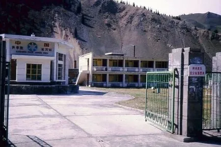
Figure 3 The base camp of the Tianshan Glaciological Station, Urumqi River valley (2100 m a.s.l.), Xinjiang (May 1988).
At the headwaters of the Urumqi River and its drainage area a large number of glaciers and cirques spread out to be admired by anyone making his or her way up from the all-year-round base camp itself (2100 m a.s.l.).Elaborate observations of the movements of ice mass and balance have been made here, including monitoring of the melt-water amounts and the geomorphological imprint.
At the time of my first visit to Glacier nr 1 the focus was on observing the movements of ice tunnel markers reflecting the ice mass flow, which was made inside a 90 m tunnel dug into the western tip of the glacial tongue.Unfortunately, too rapid melt-down made observations impossible to resume and soon the tunnel disappeared altogether. In 2003, at the time of my second visit to the site,this particular area had turned into periglacial terrain with end and lateral moraines left behind by the 140 m thick glacier (Figure 2). Lower down lay the landforms deposited by the Little Ice Age.
The Urumqi River provides the large and growing city of Urumqi with water for drinking and irrigation, and thus forms a testing region for how China will solve its problems of melting glaciers and dropping ground waters. At the same time, the population numbers are steadily increasing.The Cultural Revolution caused a break of some 10 years in the collection of monitoring data, which in 1979 simply was filled in by interpolating values earlier collected. Quite soon,the Chinese established satellite stations for remote sensing data concerted with the Americans.
From 1987 onwards, a considerable increase in melt-water was registered in Tianshan, and largely elsewhere in western China. Climate change swept into the country from the west, bringing even higher temperatures than before and increased precipitation. This was also noted at the spectacular Tianchi Lake on the northern side of the mountains in the vicinity of Bogda Feng (5445 m a.s.l.), the highest peak in the eastern end of the mountain range.
Over a period of several weeks spent with Chinese researchers in tents and stations in the area, the foundation of Finnish-Chinese cooperative work was laid (Figure 4),later extended to encompass other institutes and teams. In particular, I would like to mention Academician Shi Yafeng(Lanzhou, Nanjing), the director of the Lanzhou Institute of Glaciology and Geocryology, Chinese Academy of Sciences(CAS), and Prof. Li Zhijun (Dalian), originally a master student at the Lanzhou Institute. Other geographical areas and themes were also included.
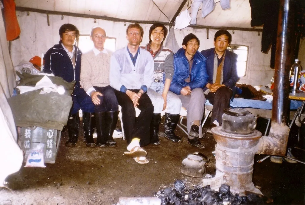
Figure 4 Tent life at the Glaciological station (May 1988). The author surrounded by Chinese personnel and a visitor from Switzerland,Professor E Schanda. The tents were smaller by the other site at the Tianchi Lake.
I met with Prof. Shi Yafeng at the INQUA Congress in Ottawa, Canada, in summer 1987. The encounter was decisive for my future visits to China and for my life-long interest in the country, its nature and culture. He was, among other things,one of the two writers of Guide to the Tianshan Glaciological Station of China (Shi and Zhang, 1984), where the work and preliminary results at the station were introduced. In 1988, this booklet proved very useful when learning about the problems and methods dealt with here over many decades.
The level of the Finnish Glacial Morphology research proved good enough and was here adapted to an entirely different alpine environment. As a result of the first visit to the station, I was asked to summarise Finnish geomorphology in an article which later was published in China (Zilliacus, 1990). In addition, some work was carried out on the correlations of glacial deposits and loess in the Gansu Province (Shen et al., 1989). Despite considerable differences between the two countries, e.g. in size and Quaternary Geology, this has not hindered fruitful exchange of concepts on glaciations and deglaciation.
3 Collaboration expands
Dalian University of Technology in Liaoning Province turned into a true base for collaboration between P. R. China and Finland. Here, the technology on traffic and oil discharge in ice-covered sea areas such as Bohai Bay in northeastern China and the Baltic Sea in northern Europe have been subject to intensive and fruitful cooperation. The activity has led to mutual visits to both countries and exchange of experience and education on navigation and sustainable operations in Arctic areas.
In the 1980’s, the Chinese did not have any stations of their own in Antarctica and participated in, e.g., Australian expeditions. Later, several Chinese stations were established and contributions were made to the global collection of data in the Antarctic. In 2019, I provided some teaching at the university summer course on Arctic navigation in Dalian (Figure 5). Next year, Prof. Li Zhijun summarised progress made in the field and the current status in a Finland-China Society lecture. Both countries do also run activities in Svalbard in Norway, in addition to other signature countries of the Svalbard Treaty on peaceful collaboration in this unique Arctic area.
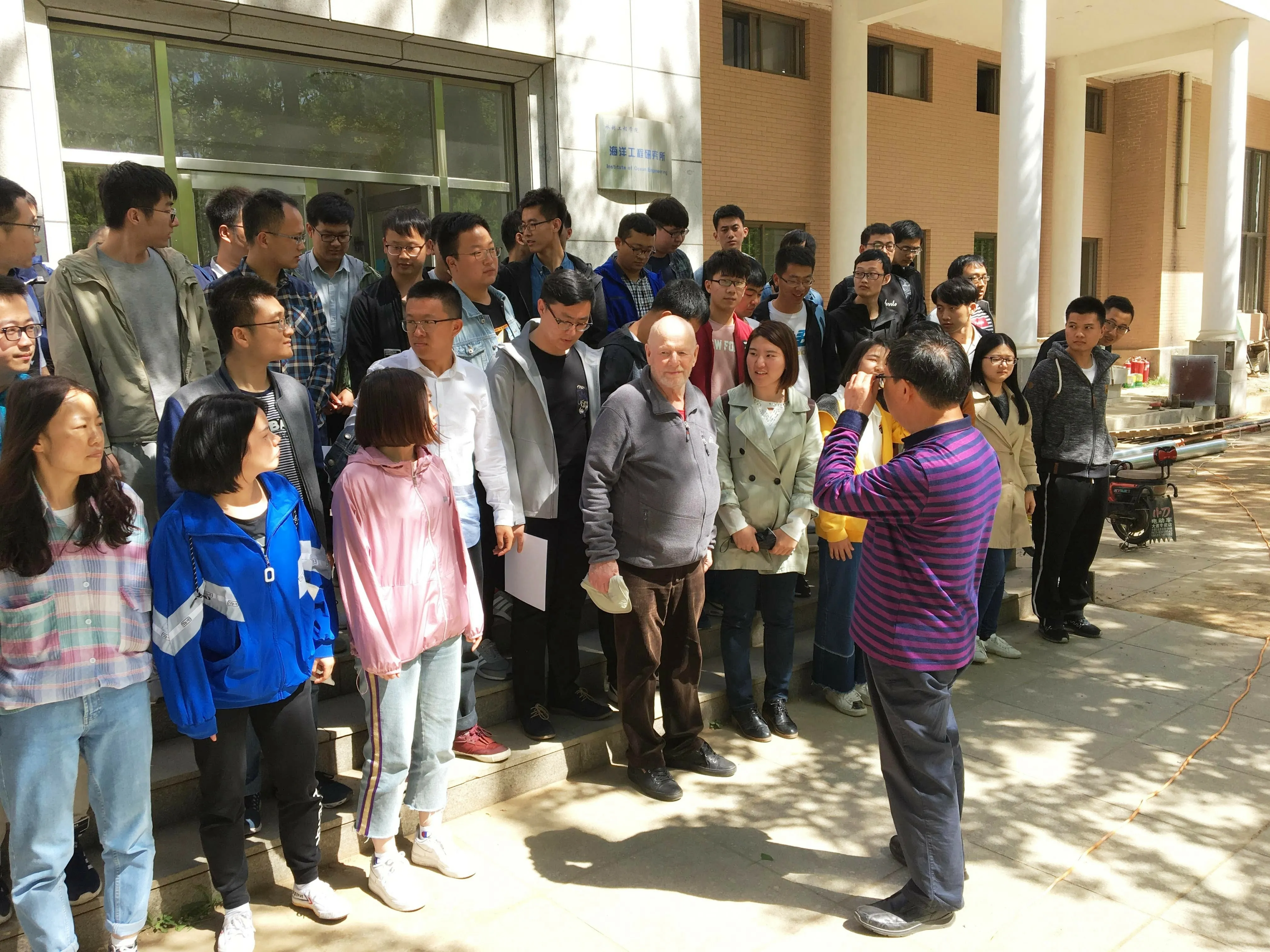
Figure 5 Summer course on Arctic navigation for postgraduate students under professor Li Zhijun, Dalian University of Technology,Liaoning Province (May 2019). Among the teachers were professor Matti Leppäranta (front row) and the author, both University of Helsinki.
It has been interesting to note how the Finnish-Chinese cooperation started on a pragmatic level and how it then ramified both geographically and thematically to include many different sectors. The precondition was largely the agreements between the Academies, which enabled trips,visits to research institutes and universities, and finally broad collaboration. This may be described as a bottom-up process, as individual scholars have been able to define the most significant themes to dig deeper in.
I have often in contexts like these found myself thinking about the Silk Roads and noted how the history of those roads or routes - on the seas as well as on land - still stands as a good example of global networking. The modern version of the Silk Road, the Belt and Road Initiative, was initiated by China’s President Xi Jinping in 2013 as an ambitious plan extending all the way to the Arctic Ocean and the new waterways in the Arctic thus circumventing the huge Eurasian continent. In these Arctic areas, global trade,the polar areas and environmental affairs will definitely stay in the focus for many decades to come.
International collaboration, ever since the Silk Roads took their first steps some 2200 years ago, has evolved into a complicated interplay. On a global scale, Finland is a relatively minor partner, but our country has ever since the People’s Republic of China was announced more than 70 years ago had a reputation of being a reliable partner.And we do have many interests in common.
In a Nordic context in conjunction with Denmark,Iceland, Norway and Sweden - all Arctic nations - we have been able to provide a larger volume and Nordic know-how besides a favourable win-win situation. Under the Nordic governmental cooperation (Nordic Council of Ministers,NordForsk), in the sectors of environment and others, I have had the pleasure to invite Chinese experts to originally Nordic projects and thus maintained the contact to innovation and modern technology carried out in the P. R.China.
In 1995 Finland became a member of European collaboration and has ever since participated in diversified cooperation between the European Union and P. R. China.We have laid out Arctic strategies both nationally and internationally guiding us in the near future, when wide focus will be directed towards Arctic, polar and subpolar areas. These areas of water, snow and ice are particularly sensitive for environmental impact, which definitely will form a surface of interaction where many interests will meet.
As investments inevitably will increase and problems get more complex, the Finnish part in some sectors of collaboration might become slightly smaller, but at the same time we might find new and significant forms of cooperation, e.g. in education and training. This is where the VTT Technical Research Centre of Finland and Aalto University in the Helsinki region have established themselves as strong actors, and where attractive opportunities have opened up for large numbers of students from China.
Finland and China do not possess vast areas in the north, and have therefore at times met in circumstances of other actors. Research on sea ice is a good example of a line of research which no doubt will be intensified in Arctic fairways in the years to come. Sea ice and lake ice may be studied on low latitudes in China, for example in the Bohai Sea in the northeast as well as on the Tibet Plateau with its numerous lakes, in the southwest. In Tibet there is deep permafrost and naturally a huge number of glaciers and their periglacial areas, which will provide scholars with invaluable data on climate change and associated impacts on living conditions in this enormous,elevated area.
4 Final remarks
On May 31st, 1988, a young researcher from Finland wrote some comments on the slides he had taken the same day:Walk on Glacier nr 1, view towards valley, ice margin, ice wall, measuring snow depth and density, velocity (flags),lateral margin, Glacier nr 1 (E-branch) and, finally, Beijing Jeep 212 (up on the road). He was overwhelmed by the surrounding five glaciers on all sides of the military tent,the base for rest and sleep for him and his Chinese colleagues.
He had learned that the 9000 glaciers only made up for some 15% of all the ice masses in China and drew his conclusion: It is here you should study ice and its consequences on landscape and people! He is not young any more, the slides have turned digital and the French morphometric method he brought from Europe may not be the cutting edge to assess how the glacial material was shaped and transported to the spot of its final deposition. At that time, though, everything was extremely exciting, and he is now more than grateful for the experience of contributing to the Finnish-Chinese adventure that unfolded.And the trip is still ongoing.
Acknowledgements
I would like to thank two anonymous reviewers,and Guest Editor Dr. Bin Cheng for their valuable suggestions and comments that improved this article.杂志排行
Advances in Polar Science的其它文章
- The rise of sea ice research collaboration between China and Finland
- Physics of Arctic landfast sea ice and implications on the cryosphere: an overview
- An overview of Antarctic polynyas: sea ice production,forcing mechanisms, temporal variability and water mass formation
- Observation and modelling of snow and sea ice mass balance and its sensitivity to atmospheric forcing during spring and summer 2007 in the Central Arctic
- An observational study of precipitation types in the Alaskan Arctic
- Variation of Antarctic marginal ice zone extent(1989-2019)
