Soil Physical Properties of Different Land Use Types in Loess Hilly Region
2021-07-21TingtingMENGJinboLIU
Tingting MENG, Jinbo LIU
Shaanxi Provincial Land Engineering Construction Group Co., Ltd., Xi’an 710075, China; Institute of Land Engineering and Technology, Shaanxi Provincial Land Engineering Construction Group Co., Ltd., Xi’an 710075, China; Key Laboratory of Degraded and Unused Land Consolidation Engineering, Ministry of Natural Resources, Xi’an 710075, China; Shaanxi Provincial Land Consolidation Engineering Technology Research Center, Xi’an 710075, China; Land Engineering Technology Innovation Center, Ministry of Natural Resources, Xi’an 710075, China
Abstract [Objectives] To explore the impact of land use changes on physical properties of soil in loess hilly region. [Methods] The methods of field sampling and indoor analysis were adopted. Farmland in a small watershed in the middle of the Loess Plateau, grassland that had been abandoned for 7 years, grassland that had been abandoned for 30 years, jujube orchard and ditch were sampled, and the particle composition (clay, silt and sand) and moisture changes of the soil in the top 0-100 cm were studied. [Results] In the small watershed, the top 0-100 cm of the soil was composed of 14% clay, 70% silt and 16% sand. The contents of clay, silt and sand in the grassland that had been abandoned for 30 years varied greatly, while varied little in the land of other use types. The soil moisture content of grassland that had been abandoned for 30 years, jujube orchard, grassland that had been abandoned for 7 years, farmland and ditch increased with the increase of depth, with means of 10.29%, 11.66%, 10.08%, 11.43% and 11.34%, respectively. [Conclusions] This study provides a theoretical basis for the growth of crops of different land use types in the loess hilly region.
Key words Loess hilly region, Land use type, Particle composition, Soil moisture
1 Introduction
After the implementation of the project of returning farmland to forest (grassland) in 1999, vegetation on the Loess Plateau has been well restored, and land use types have been diversified. The change of land use type is highly valued by scholars at home and abroad, due to its potential impact on the global carbon cycle, soil quality, land management and regional economic development. In the Loess Plateau of China, after returning farmland to forest and grassland, the organic carbon and total nitrogen contents of the top 0-100 cm soil of grassland, woodland and shrub land increased compared with those in the original farmland. Soil physical properties are one of the main factors affecting soil nutrients and crop growth. Changes in land use types will also directly affect the physical properties of the soil. The composition of soil particles affects the hydraulic characteristics and fertility of the soil. It is directly related to soil erosion and degradation, and is one of the important soil physical characteristics.
In this paper, taking the typical small watershed of the loess hilly region as a unit, the changes in the particle composition and moisture content of the top soil (1-100 cm) of different land use types were studied, in order to provide a scientific basis for the management of land and soil resources and the sustainable development of returning farmland to forest (grassland) project in small watersheds in the loess hilly region.
2 Materials and methods
2.1 Overview of the study area
The study area is located in a small watershed in the middle of the Loess Plateau. The terrain of the small watershed is complex. The higher part is steep hilly slopes, most of which have a slope greater than 20°, and the lower part is heavily eroded gully. The study area has a typical semi-arid climate. The annual precipitation is about 505 mm, and 70% of the precipitation is concentrated in July, August and September. The annual average temperature is 8.6 ℃, with lowest temperature (-6.5 ℃) in January and highest temperature (22.8 ℃) in July. Except for the bottom of the ditch, the entire small watershed is covered by a deep loess layer and the groundwater depth may be below 50 m. The main types of land use in the watershed are farmland, abandoned grassland for 7 years, and abandoned grassland for 30 years and jujube orchard.2.2 Test design
In August, 2016, a total of 53 sampling points were randomly selected in the watershed, including 17 for farmland, 10 for grassland that had been abandoned for 30 years, 11 for grassland that had been abandoned for 7 years, 17 for jujube orchard, and 28 for ditch. The soil was sampled with a soil drill with a diameter of 40 mm. For each sampling point, the soil at three different positions was sampled and mixed. The soil was divided into 5 layers, 20 cm for each layer. The soil of each layer was sampled and mixed evenly. After removing miscellaneous things, part of each soil sample (300-400 g) was put into a ziplock bag and brought back to the laboratory for determination of soil particle composition (sand, 2-0.02 mm; silt, 0.02-0.002 mm; and clay, <0.002 mm) using Malvern laser particle size analyzer. The remaining part of each soil sample (30-40 g) was packed into an aluminum box with a diameter of 50 mm and brought back to the laboratory for the determination of moisture content.2.3 Data analysis
Data processing was performed using Excel 2010, and drawing was completed using oringe 2018.3 Results and analysis
3.1 Soil particle composition
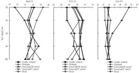
In grassland that had been abandoned for 30 years, the contents of clay, silt and sand were 11.7%, 68.75% and 19.52%, respectively; in jujube orchard, the contents of clay, silt and sand were 13.58%, 70.89% and 15.58%, respectively; in farmland, the contents of clay, silt and sand were 12.94%, 70.22% and 16.83%, respectively; in grassland that had been abandoned for 7 years, the contents of clay, silt and sand were 13.63%, 70.39% and 15.81%, respectively; and in ditch, the contents of clay, silt and sand were 13.88%, 70.90% and 15.22%, respectively (Fig.1). Among different land use types, the content of clay was lower in grassland that had been abandoned for 30 years and higher in ditch, and the content of sand was higher in grassland that had been abandoned for 30 years and lower in ditch. The main reason for the high sand content and low clay content of 30-year-old abandoned grassland and farmland may be that the two are often affected by human farming activities, resulting in loose surface soil, so that the fine soil particles are lost due to external forces such as runoff and monsoon. The main reason for the high clay content of ditch may be that there is less interference from human activities. In the soil of different use types, the contents of silt and clay both decreased with the increase of depth. This is because that fertilization application in farmland and jujube orchard significantly increases the content of fine particles in the surface layer of 0.1-0.2 mm, and dung from sheep grazing also increases the content of surface clay.
Fig.1 Vertical distribution of soil texture fractions in the land of different use types
3.2 Soil moisture content
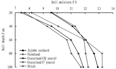
In the land of four use types (farmland, 7-year-old abandoned grassland, 30-year-old abandoned grassland and jujube orchard), the soil moisture content increased with the increase of depth. The soil moisture contents of 30-year-old abandoned grassland, jujube orchard, 7-year-old abandoned grassland, farmland and ditch were 10.29%, 11.66%, 10.08%, 11.43% and 11.34%, respectively. Jujube orchard and farmland showed high moisture content, while 7-year-old abandoned orchard and 30-year-old abandoned grassland showed low moisture content. This difference is related to farming patterns and more vegetation cover on farmland, which reduces ground water evaporation. In the soil layer of 0-60 cm, the soil moisture contents of different land use types were in the order farmland>jujube orchard>ditch>30-year-old abandoned grassland>7-year-old abandoned grassland; and in the soil below 60 cm, the soil moisture contents of different land use types ranked as ditch>jujube orchard>farmland>30-year-old abandoned grassland>7-year-old abandoned grassland (Fig.2). The higher moisture content of jujube orchard than that of farmland in the soil below 60 cm is related to the root system of jujube trees.
Fig.2 Vertical distribution of soil moisture in the land of different use types
4 Conclusions
In the soil layer of 0-100 cm of the entire small watershed, the contents of clay, silt and sand were about 14%, 70% and 16%, respectively. The contents of sand, silt and clay varied more greatly in the grassland that had been abandoned for 30 years, while changed little in the other land use types. In farmland, jujube orchard, 30-year-old abandoned grassland, 7-year-old abandoned grassland and ditch, the soil moisture content increased with the increase of depth. The average moisture contents of 30-year-old abandoned grassland, jujube orchard, 7-year-old abandoned grassland, farmland and ditch were 10.29%, 11.66%, 10.08%, 11.43% and 11.34%, respectively. The average bulk densities of the soil layers of 0-20, 20-40, 40-60, 60-80 and 80-100 cm were 1.26, 1.29, 1.31, 1.35 and 1.34 g/cm, respectively. The average bulk density of the soil layer of 0-40 cm was lower.
杂志排行
Asian Agricultural Research的其它文章
- Implications from Park Public-Private Partnership (PPP) Initiatives in China and Japan
- Impact of Coal Mining Subsidence on Sandy Geomorphology and Vegetation Habitat in Sandy Area
- Dynamic Control System of Automatic Monitoring Equipment for Waste Gas Pollution Source
- Study on Change Rules and Influencing Factors of Soil Moisture in Huaibei Plain
- Threats and Avoidance Measures of Frost Damage of ‘Shushanggan’ Apricot in the Ili River Valley
- Effect of Different Afforestation Treatments on Growth of Salix microstachya
