Evaluation of All-Sky Assimilation of FY-3C/MWHS-2 on Mei-yu Precipitation Forecasts over the Yangtze-Huaihe River Basin
2021-07-08YuLIKeyiCHENandZhipengXIAN
Yu LI, Keyi CHEN*, and Zhipeng XIAN
1School of Atmospheric Sciences, Chengdu University of Information Technology, Chengdu 610025, China
2International Center for Climate and Environment Sciences, Institute of Atmospheric Physics,Chinese Academy of Sciences, Beijing 100029, China
3University of Chinese Academy of Sciences, Beijing 100049, China
ABSTRACT All-sky (i.e., clear, cloudy, and precipitating conditions) assimilation of microwave observations shows potentially positive impacts on the improvement of the forecasts of cloud-associated weather processes.In this study, a typical mei-yu heavy precipitation event that occurred in 2017 was investigated, and the Weather Research and Forecasting data assimilation (WRFDA) as well as its 3D-Var assimilation scheme (excluding cloud and precipitation control variables)were applied to assimilate the Fengyun-3C (FY-3C) Microwave Humidity Sounder-2 (MWHS-2) observations under clearsky (excluding the observations that are strongly affected by ice clouds and precipitation) and all-sky conditions.Three experiments including a control experiment without assimilating any observations, clear-sky, and all-sky experiments with only FY-3C/MWHS-2 observations assimilated were carried out.The results show that the all-sky assimilation approach that provides more cloud and precipitation information and increased more than 10% of the satellite data usage than the clear-sky experiment.Meanwhile, as compared with the control experiment, the all-sky assimilation reduced nearly 0.5% of the root mean square errors in the humidity fields, leading to more accurate forecast performances regarding the distribution and intensity of heavy rainfall; but it exhibited a neutral to negative impacts on the wind and temperature.Although the system used to conduct all-sky assimilation is only able to adjust control variables for moisture-, wind-, and temperaturerelated variables in the presence of cloud and does not benefit directly from cloud or precipitation information, the positive effects on heavy rainfall forecasts achieved in this study indicate a potential future benefit regarding disaster prevention and mitigation.
Key words: all-sky assimilation, FY-3C, MWHS-2, mei-yu rainfall
1.Introduction
Mei-yu frontal rainstorms occur in the summer (i.e.,June and July) and cause severe flood disasters and massive damage to people’s lives and property.The suddenness and locality of the mei-yu frontal rainstorms increase the difficulty of predictions (Hu and Ding, 2010; Sun et al., 2019),making the accurate forecasting of mei-yu frontal rainfall an urgent and challenging issue.
With the rapid development of advanced techniques in numerical weather prediction (NWP), assimilation of radar and conventional observations has already shown varying improvements in precipitation predictions (Xu et al., 2006;Wang et al., 2012; Liu et al., 2016; Li et al., 2018; Lai et al.,2020).However, the coverage of conventional observations is relatively uneven (i.e., weather stations are sparse in the ocean, desert, or depopulated zones), and the duration of thepositive effect of radar observations on forecasts may be as short as six hours (Fan et al., 2013).Therefore, these data could hardly offer adequate high-resolution information for the NWP initial fields.Satellite observations are ideal for the improvement of initial fields due to their high resolution, quasi-continuity, and tremendous coverage.Qi et al.(2005) assessed the influence of assimilation on mei-yu frontal rainfall simulation by directly and indirectly assimilating the Advanced Television InfraRed Observation Satellite Operational Vertical Sounder (ATOVS) radiance data,showing that the best simulation among the three experiments was the direct assimilation, which can describe the main features of the observations.Direct assimilation of satellite observations has extensive prospects in rainstorm prediction.Guo et al.(2010) suggested that ATOVS observations could cover the shortage of conventional data in a barren area, and a more exact simulation of precipitation would be produced when the ATOVS data were continuously assimilated.For the rainfall over the Yangtze River basin, a similar result was also achieved in the study carried out by Zhang et al.(2016), who employed the Weather Research and Forecasting (WRF) model and its data assimilation system (WRFDA) to examine the performances of forecasts with different types of satellite data being assimilated [i.e.,ATOVS and the Infrared Atmospheric Sounding Interferometer (IASI)].
These previous studies assimilated only cloud-free radiance data, that is, clear-sky observations.However, many high-impact weather processes (e.g., mei-yu frontal heavy rainfall and tropical cyclones) are largely associated with clouds and precipitation, and making good use of cloud-contaminated radiance data is crucial to improve weather forecasts.Due to the poor knowledge regarding the nonlinearity of moisture physical processes, assimilating cloud- and rain-affected radiances will lead to highly non-Gaussian behavior (Geer and Bauer, 2010, 2011), thereby failing to meet the requirement of data assimilation and making it difficult to extract the values of cloud and rain information.With good knowledge of the observational errors related to cloud- and rain-affected radiances, Geer and Bauer (2010,2011) proposed a new scheme to assign observational errors to cloud- and rain-contaminated radiances, leading to a transition in the satellite data assimilation method from a clearsky approach to an all-sky approach in many operational weather forecast centers, such as the European Centre for Medium-Range Weather Forecasts (ECMWF) (Bauer et al.,2010), and the Japan Meteorological Agency’s Global NWP system (Kazumori and Kadowaki, 2017).Positive impacts have been shown with all-sky schemes employed in these operational centers, and efforts have started to focus on assimilating cloud-affected infrared radiances (Geer et al., 2018).On the other hand, all-sky assimilation has also been employed in regional models to improve weather forecasts,especially for tropical cyclones, such as assimilating the Advanced Microwave Scanning Radiometer 2 radiances with the WRF model and Community Radiative Transfer Model (Yang et al., 2016) and assimilating the FengYun-3C Microwave Humidity Sounder-2 (FY-3C/MWHS-2) with the WRF model and the all-sky component of the Radiative Transfer Model for Television Infrared Observation Satellite Operational Vertical Sounder (RTTOV-SCATT) to improve the forecast performance on binary typhoons (Xian et al., 2019).
Surface emissivity, one of the important parameters for calculating the brightness temperatures in data assimilation,is difficult to retrieve with accuracy because of the presence of clouds and precipitation (Baordo et al., 2012, 2013).There are three main methods to estimate surface emissivity: a surface emissivity model, an emissivity atlas, and dynamic emissivity.A surface emissivity model requires several input factors (i.e., vegetation coverage, snow depth,etc.) that cannot always be accurately derived from the NWP model, and it may produce an unacceptable result (Prigent et al., 2006; Qian et al., 2016).A monthly mean emissivity atlas derived from satellites (Aires et al., 2011) has become one of the mainstream methods in most NWP centers.Among these methods, dynamic emissivity retrieved from microwave window channels (Karbou et al., 2010a, b)seems to be an effective approach to indicate realistic changes in surface conditions.The dynamic emissivity method employed in Karbou et al.(2010a, b) improves the accuracy of the simulated brightness temperature.Karbou et al.(2010a, b) assessed the impact of this method, and the results showed that dynamic surface emissivity could reduce the standard deviation of the first guess departures.Chen et al.(2018) demonstrated that using the FengYun-3B/Microwave Humidity Sounder (FY-3B/MWHS) window channel to retrieve surface emissivity significantly increased the usage of assimilated data over land, especially over snow-covered areas, and the impacts on forecasts were slightly improved over the first five days.However, Chen et al.(2018) applied a global model at a low spatial resolution to assimilate the observations only in the clear and lightly clouded area.Xian et al.(2019) retrieved surface emissivity in a regional model that was closer in scale to the observations to assimilate the observations contaminated by the clouds and precipitation, producing a better prediction of heavy rainfall.However, the process was mainly conducted over the ocean, where the surface is simpler and more unified.Since unphysically-based emissivity retrievals can also occur under strong scattering conditions(Baordo and Geer, 2016), how the retrieved emissivity over land impacts the weather forecasts of a regional model is worthy of interest, and it will be evaluated in this study.
FY-3C is the first operational satellite of the second-generation polar-orbiting meteorological satellites of China.Since microwaves have a great ability to penetrate nonprecipitating clouds, the onboard MWHS-2, which has window channels and 118 GHz and 183 GHz channels, can offer vertical profile information of temperature and humidity simultaneously compared with visible and infrared wavelengths.These features can compensate for the uneven coverage of conventional observations and the low accuracy of detection in the middle and upper troposphere.Note that this isthe first time 118 GHz has been used on a polar-orbiting satellite worldwide.A series of studies has been carried out to evaluate the quality of FY-3C/MWHS-2 observations(Lawrence et al., 2015,2018; Lu et al., 2015, Carminati et al., 2018), which demonstrates that assimilating FY-3C/MWHS-2 observations has a considerable positive effect on weather forecasts.Based on these evaluations,Xian et al.(2019) indicated that assimilation of FY-3C/MWHS-2 under all-sky conditions improved the forecasts of wind, temperature, and humidity and accurately captured the features of the core structures of two typhoons.Jiang et al.(2020) pointed out that FY-3C/MWHS-2 improved the 6-hour prediction and reduced the standard deviation of absolute humidity observation errors by 0.55%—1%.To evaluate the impacts of the all-sky assimilation of MWHS-2 on the prediction of heavy rainfall caused by the mei-yu front over land, a typical mei-yu frontal rainstorm process (from 1200 UTC 27 June 2017 to 1200 UTC 3 July 2017) was selected in this study.
The structure of this paper is as follows: an introduction to mei-yu rainfall is described in section 2 before a series of methods applied in this study are provided in section 3.Section 4 illustrates the assimilation and forecast impacts,and the conclusion and discussion are given in section 5.
2.Brief introduction to the mei-yu rainfall case
The heavy rainfall event over the middle and lower reaches of the Yangtze River lasted from 28 June to 3 July 2017 was selected to evaluate the impact of the all-sky assimilation of FY-3C/MWHS-2 on heavy rainfall prediction..It began to rain early on 28 June, and heavy rainfall occurred on 30 June.The rain process did not terminate until 3 July due to the existence of the quasi-stationary front.During the rainfall period, the base of the trough was located in eastern China.In the Jianghuai area, there was obvious divergence at 200 hPa.This situation enhanced the pumping effect,which was conducive to the development of southerly and northerly wind shear and low-level convergence.In addition, the western Pacific subtropical high (WPSH) extended to 110°E, which promoted the transport of water vapor from both the South China Sea (SCS) and the Bay of Bengal.Overall, abundant moisture and the accumulation of instability triggered this rainstorm over the Yangtze-Huaihe River Basin.This persistent rainfall process triggered severe flooding of the Xiangshui, Zishui, and Yuanshui Rivers, causing over 11 million individuals to suffer in 11 provinces, including Guangdong, Zhejiang, and Anhui Provinces.
3.Data and methodology
3.1.FY-3C/MWHS-2
The FY-3C satellite was launched at the Taiyuan Satellite Launch Center on 23 September 2013 and is polar-orbiting with an equatorial crossing time of 0215UTC.The onboard MWHS-2 has 15 channels, including two window channels at 89 and 150 GHz used for background microwave radiation detection, precipitation detection, and surface emissivity retrieval; five channels sample the 183 GHz water vapor absorption line, and eight channels sample the 118 GHz atmospheric oxygen absorption line.Moreover, as mentioned in section 1, the 118 GHz channels are being flown in a microwave sounder for the first time, and they are sensitive to both humidity and temperature.The fields of view (FOVs) for channels 1—9 and 10—15 are 32 km and 16 km, respectively.Each scan line has 98 FOVs.Lawrence et al.(2015) demonstrated that the best information layers for channels 1 and 7—10 are the surface,for channels 2—4 are the stratosphere and for channels 11—14 are the upper, middle, and lower troposphere.Such channel characteristics can compensate for the limitations of conventional observations with their uneven coverage and poor accuracy of humidity detection in the middle and upper troposphere.
3.2.WRFDA
The WRFDA system (version 3.6) includes the threedimensional variational (3D-VAR), four-dimensional variational (4D-VAR), and hybrid data assimilation schemes.A 3D-VAR assimilation scheme was adopted in this study to obtain an optimal analysis through iterative minimization of the cost function.The cost function is described as follows:

y
represents the observation, andH
represents the observation operator that transforms the model variables into the observation variables.The RTTOV-SCATT(version 12.0) package, which was developed and maintained by the European Organisation for the Exploitation of Meteorological Satellites (EUMETSAT) Satellite Application Facility on Numerical Weather Prediction (NWP SAF)(Bauer et al., 2006), was used as the observation operator in this study.However, since the official version of the WRFDA can only carry out clear-sky assimilation with the clear-sky component of RTTOV implemented, Xian et al.(2019) has developed the WRFDA system with RTTOVSCATT employed to achieve all-sky assimilation.B and R represent background and observation error covariance matrices, respectively.The background error covariance matrix B is one of the important components to obtain an optimal analysis through a variational assimilation scheme.In this study, the default control variables (CV option five),including the stream function, unbalanced velocity potential, unbalanced temperature, unbalanced surface pressure,and pseudo relative humidity, were employed, and the National Meteorological Center (NMC) method (Parrishand Derber, 1992) was adopted to calculate the background error covariance.B can be calculated by the difference of valid forecasts at the same time.For example, the difference between the 24-hour forecast and the 12-hour forecast is as follows:
X
represents the forecast result of 24-hour integration at the initial time of t = 24, whileX
represents the forecast result of 12-hour integration at the initial time of t = 12.3.3.Observation errors
Under all-sky conditions, the first guess (FG) simulated by the RTTOV-SCATT is inconsistent with the observations in the displacement of clouds and rain, causing a highly non-Gaussian behavior of the first guess departure(observation minus first guess, OMB).However, the OMB is required to be unbiased and to satisfy a Gaussian distribution in the framework of assimilation theory.Therefore, it is necessary to correct the non-Gaussian observation errors to satisfy the requirements.The symmetric error model proposed by Geer and Bauer (2010, 2011) has the ability to assign suitable observation errors to the highly non-Gaussian behavior of OMBs.It can be expressed as follows:

g
andg
represent the observation errors in clearsky and all-sky conditions, respectively.C
andC
represent the minimum of the symmetric predictor and the maximum of the symmetric predictor, respectively.Descriptions of the observation error model for FY-3C/MWHS-2 can be found in Xian et al.(2019).Figure 1 (Xian et al.,2019) shows the standard deviations of the MWHS-2 statistical first guess departures (dashed lines) and the standard deviations of observation errors calculated by the symmetric error model (solid lines) in channels 5—9 (Figs.1a, b) and 11—15 (Figs.1c, d).3.4.Surface emissivity
Surface emissivity (i.e., the ratio of radiant energy emit-ted from the surface to that from an ideal blackbody at the same temperature) is a measure of the inherent efficiency of the surface in converting heat energy into radiant energy above the surface (Sobrino et al., 2001).It is a crucial parameter in radiative transfer models, land surface remote sensing, and satellite data assimilation.The surface emissivity not only depends on the frequency, polarization mode, and incidence angle but is also influenced by the features of the surface, such as soil particle size, mineral contents, surface roughness, and vegetation properties (Prabhakara and Dalu,1976; Salisbury and D’Aria 1992; Wilber et al., 1999; Prigent et al., 2000; Zhou et al., 2008).Due to the complexity and variability of surfaces, it is difficult to accurately simulate the radiation from land surfaces.A more accurate estimation of surface emissivity is important for the simulation of the brightness temperature and the assimilation process.Therefore, it is necessary to estimate the surface emissivity precisely.
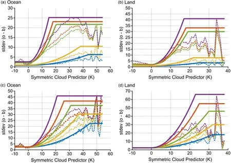
Fig.1.The standard deviations in the Microwave Humidity Sounder-2 first guess departures (dashed lines) as functions of the symmetric cloud predictors for channels 5—9 (top; blue: channel 5; yellow: channel 6; green: channel 7; red: channel 8;and purple: channel 9) and 11—15 (bottom; blue: channel 11; yellow: channel 12; green: channel 13; red: channel 14; and purple: channel 15) over the ocean (a, c) and land (b, d) along with the applied observation errors (solid lines).The statistics are based on a sample of 1 043 893 observations without quality control (Xian et al., 2019).
In this study, we adopt two methods to estimate surface emissivity: the one is directly using the Tool to Estimate Land Surface Emissivity at Microwaves and Millimeter waves atlas (TELSEM) (Aires et al., 2011), which is the average monthly surface emissivity data.The other is the surface emissivity retrieved from the microwave window channel (i.e., 89 GHz).The surface emissivity can be derived by the equation of brightness temperature (Baordo et al.,2012):

Therefore, the algorithm of surface emissivity is as follows:


4.Assimilation experiment
4.1.Experimental settings
Three experiments, including a control experiment (CONTROL) without any data assimilation, a clear-sky experiment (CLEARSKY) assimilating FY-3C/MWHS-2 observations under clear-sky conditions, and an all-sky experiment(ALLSKY) assimilating clear and cloud-contaminated radiances under all-sky conditions, were carried out to assess the impact of all-sky assimilation on mei-yu rainfall forecasts.The Advanced Research WRF system (version 3.9)(Skamarock et al., 2008) was applied.The model configurations include the Lambert projection, 300 × 261 grids, and a horizontal resolution of 15 km.The center of the model domain is located at (35.1°N, 111.2°E) with 41 eta levels in the vertical direction, and the model top is 10 hPa.The time step is 60 s.The main physical parameterization schemes, similar to Yang et al.(2016) and Xian et al.(2019), are as follows.The Lin scheme (Lin et al., 1983) is chosen as the microphysics scheme, and the Tiedtke scheme (Tiedtke,1989) is selected as the cumulus convection scheme.The Noah land surface scheme (Tewari et al., 2004), the Mellor-Yamada-Janjic boundary layer scheme (Janjić, 1994), and the Rapid Radiative Transfer Model for General Circulation Models radiation scheme (Iacono et al., 2008) are employed in this study.RTTOV-SCATT, a fast radiative transfer model that can simulate the radiances in all-sky conditions, is selected as an observation operator, as mentioned in section 3.3.For channel selection, Lawrence et al.(2015)pointed out that the standard deviations of the first guess departures for channels 13 and 14 are 2 K and 3 K, respectively, which are greater than those for other channels at 0.2—0.3 K.Thus, this study applied the same channel scheme as ECMWF (i.e., channels 2—7, 11, 12, 15 were assimilated).The model integration time is from 0000 UTC 28 June 2017 to 0012 UTC 3 July 2017 in the three experiments.The 12-hour cycles of assimilation experiments are carried out under both clear-sky and all-sky conditions.The background of the first analysis is the 12-hour forecast initiated from 1200 UTC 27 June 2017 using the National Center for Environmental Prediction (NCEP) Global Data Assimilation System (GDAS) analysis data, and the background for the following analysis is provided by the 12-hour forecast initialized from the previous cycle’s analysis.The analyses are generated every 12 hours, and the lateral boundaries are updated by the GDAS forecasts at 6-hour intervals.
4.2.Quality control and bias correction
Before assimilation, we need to eliminate the large errors caused by instruments and other reasons to ensure the quality of observations.A quality control scheme (Liu et al.,2012; Xian et al., 2019) including an extreme value check(to remove the data with brightness temperatures greaterthan 550 K or lower than 50 K), a surface type check (to remove data over the mixed surface types), a scanning angle check [to remove the first five scan angles in each swath edge (Lawrence et al., 2015)], an elevation check (to remove the data over 1500 m in channel 11, 1000 m in channels 12 and 13, and 800 m in channels 14-15), an edge check (to remove observations with latitudes greater than 60° in channels 14-15), and an absolute departure check (to remove observations whose OMB was greater than three timesg
(C
) after bias correction) was adopted.Moreover, in the clear-sky assimilation, we need to remove the observations with cloud liquid water paths (CLWPs)greater than 0.2 and OMBs for channel 10 greater than 5 K over the ocean and 3 K over the land (Chen et al., 2015).To weed out the systematic errors between the simulated brightness temperatures and the observed brightness temperatures,the WRFDA variational bias correction scheme (Harris and Kelly, 2001; Dee, 2004; Auligné et al., 2007) was utilized for the bias correction of FY-3C/MWHS-2.4.3.Assimilation impact
As discussed in section 3.4, before the observations are assimilated in all-sky conditions, the non-Gaussian behavior of observation errors must be effectively addressed by the situationally dependent symmetric error model so that the quality of the analysis can be guaranteed.The statisticsg
were used as the observation errors in CLEARSKY,while the observation errors in ALLSKY can be calculated by the symmetric error model, which assigns observation errors that vary as a function of the cloud amount to these radiances (Geer et al., 2010).Figure 2 shows the probability distribution function (PDF) of the absolute and normalized first guess departures before quality control in ALLSKY.The PDFs of the absolute first guess departures for channels 6, 7, 12, and 15 are displayed in Figs.2a—d.Note that there are positive biases in the absolute OMBs for channels 7, 12, and 15, indicating that the observation and model disagree in terms of clouds or precipitation amount.According to an evaluation of FY-3C/MWHS-2 carried by Lawrence et al.(2015), channels 12 and 15 are sensitive to humidity, and channel 7 is sensitive to not only temperature but to water vapor, as the weighting function peak is low enough (channels 2—4 peak is too high to be sensitive to clouds and water vapor, channels 5—6 have a weak sensitivity to water vapor).In the presence of cloud and precipitation, the accuracy of the simulated radiances for those channels sensitive to water vapor is relatively lower, which may lead to positive biases.The large absolute value of OMBs means that the observations and models are inconsistent in cloud and rain judgment.Compared with Figs.2e—h, the absolute first guess departures exhibited highly non-Gaussian behavior with large departures before being normalized(e.g., for channel 15 as much as 60 K, and the skewness and kurtosis of PDF were —3.016 and 17.887, respectively),which is similar to the results from Geer and Bauer (2010)who evaluated the performance of the Special Sensor Microwave/Imager (SSMI) in the all-sky assimilation.The distribution of normalized departures approximately conformed to a Gaussian distribution after the application of the symmetric error model, which satisfied the basic assumption of the assimilation theory.For example, for channel 15 normalized departures with magnitudes greater than 4 were infrequent, and the skewness and kurtosis of PDF decreased to 0.286 and 1.750, respectively.Only when the two statistic variables were close to zero was the distribution of OMBs close to a Gaussian distribution.Additionally, Geer and Bauer (2010) demonstrated that the quality control process of cloud- and rain-contaminated radiances will perform best when OMBs are normalized.The number of assimilated FY-3C/MWHS-2 observations was different between ALLSKY and CLEARSKY, as displayed in Fig.3.The background image was the FY-2G satellite Black Body Temperature product at 0000 UTC 30 June 2017, which can be found at the National Satellite Meteorological Center.The cloud belt of the mei-yu front was mainly concentrated in the Yangtze-Huaihe River Basin,which was consistent with the precipitation area.The green dots in Figs.3a, b represent the coverage of observations,and this distribution revealed that the number of observations assimilated in ALLSKY was much greater than that in CLEARSKY, for example, the usage rates (the number of the used pixels divided by all observed pixels) of FY-3C/MWHS-2 observations for channel 11 over the whole assimilation period are 52.67% and 67.06% in CLEARSKY and ALLSKY, respectively.The extra observations were mainly located in the thick cloud area, which was beneficial to mei-yu rainfall prediction.As for the surface emissivity, the retrieved emissivity does display bigger variations over clear areas (i.e., the area along the coastline of the Chinese mainland and Taiwan island) compared to the emissivity atlas (Figs.3c—e).According to Baordo and Geer(2016), the depressed brightness temperatures affected by the strong scattering of thick clouds would lead to unphysically justified lower emissivity retrievals, and this problem affects the CLEARSKY and ALLSKY emissivity retrievals equally.However, the dynamic emissivity in ALLSKY exhibited smaller variations than that in CLEARSKY, and more detailed surface variations presented in CLEARSKY (Fig.3d) were clouds instead of the true variations in the surface while this fake surface variation in ALLSKY (Fig.3e) was minor.These differences may be down to the tighter quality control of emissivity retrievals in ALLSKY as compared with CLEARSKY as mentioned in section 3.4.It is interesting to investigate whether the accuracy of the retrieved emissivities in CLEARSKY would be improved by applying the same criteria for quality control of emissivity retrievals as in ALLSKY in future work.
Figure 4 shows the spatial distribution of the observations minus analyses (OMAs) and OMBs of assimilated observations at 1200 UTC 30 June 2017 after space thinning of 60 km, quality control, and bias correction.The dots represent the MWHS-2 observation pixels, and their colors represent the values of the brightness temperatures of OMAs and OMBs.Figure 4a displays the distribution of OMBs in CLEARSKY.The number of assimilated pixels was 2059,with a data utilization of 56.1%.The number of pixels used was 2458 in ALLSKY, with a usage of 70.0% (Fig.4c).This confirmed that the all-sky approach could significantly increase the utilization of satellite data.Moreover,since the yellow dots indicate small departures and the red and blue dots indicate large departures, compared with the values of the OMBs, the values of the OMAs are much smaller, meaning that the analysis field (Figs.4b, d) was closer to the observations than the background (Figs.4a, c).
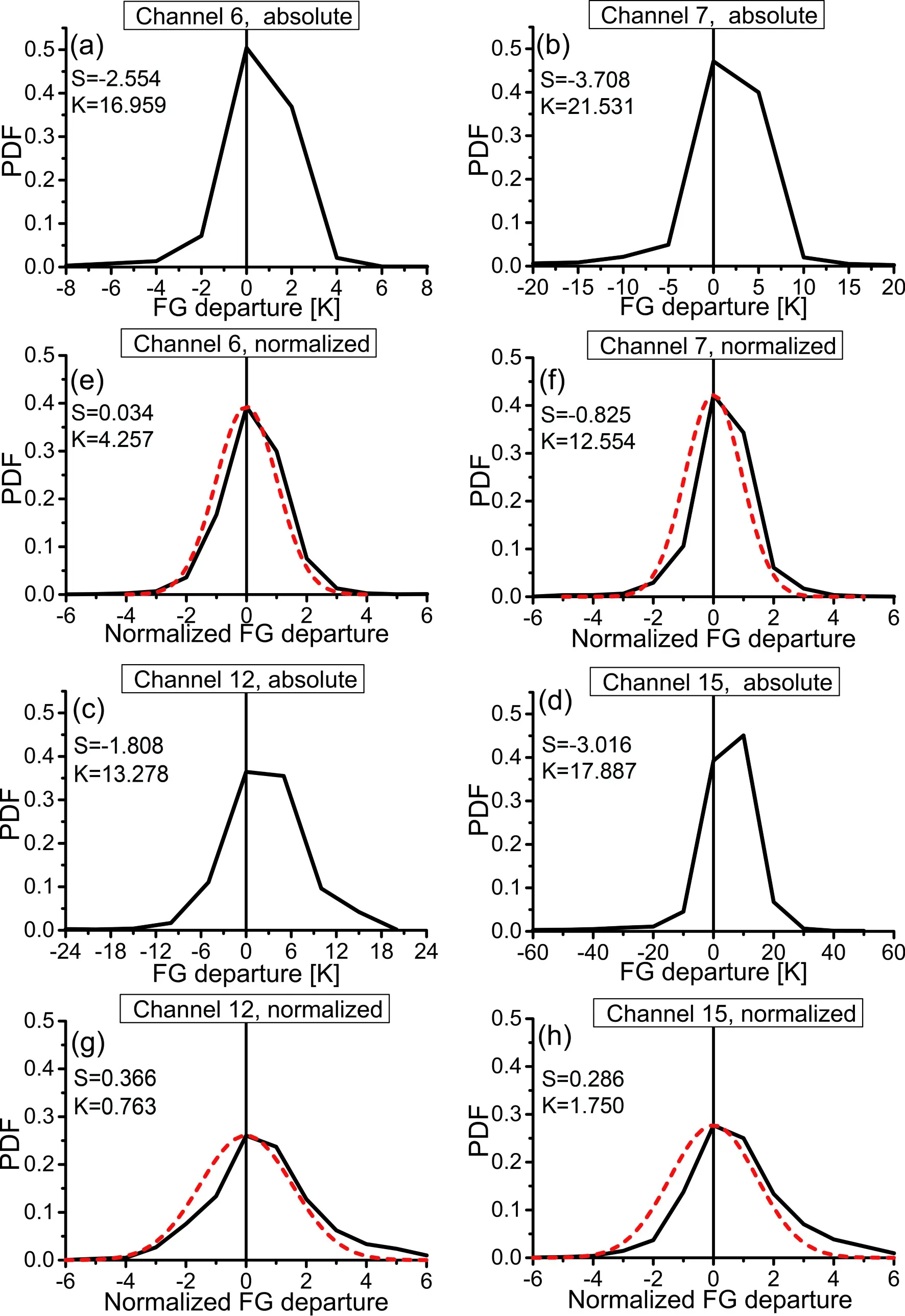
Fig.2.The PDFs of the first guess departures in terms of the absolute brightness temperature (a—d) and normalized by the observation error model (e—h) in ALLSKY for channels 6, 7, 12, and 15 of FY-3C/MWHS-2 (the black line represents the distribution of the sample observations; the red line represents a roughly fitted Gaussian line; S represents the skewness of the PDFs, K represents kurtosis of the PDFs.
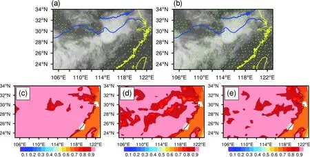
Fig.3.Top: The coverage of the FY-3C/MWHS-2 observations for channel 15 in clear-sky assimilation (a) and all-sky assimilation (b) (blue lines represent the Yangtze-Huaihe River Basin).The background is the FY-2G satellite black body temperature product at 0000 UTC 30 June 2017.Bottom: The emissivity from the atlas (c), clear-sky emissivity retrievals(d), and all-sky emissivity retrievals (e) for MWHS-2 channel 15 after quality control at 0000 UTC 30 June 2017.
To further understand the characteristics of the OMAs and OMBs, the time series of OMAs (red line) and OMBs(black line) for channel 11 as an example from 0000 UTC 28 June 2017 to 0000 UTC 3 July 2017 are presented in Fig.5.The average OMB was —1.21 K at 0000 UTC 2 July 2017 in CLEARSKY, while the average OMA was —0.10 K.The average OMA was closer to zero than the average OMB,meaning that the analysis field was a better fit to observations after assimilation.Similar results can be reflected over the entire time series.Comparing the average OMB in CLEARSKY and ALLSKY (Figs.5a, b), the average first guess departure in ALLSKY was generally smaller than that in CLEARSKY.Figures 5c and 5d show the standard deviations of OMAs and OMBs, which represent the dispersion degree of samples based on the average values.The standard deviation of OMBs in CLEARSKY (black line in Fig.5c) was smaller than that in ALLSKY (black line in Fig.5d)since the background was obtained from RTTOV-SCATT was inconsistent with the observations in the rain judgment.The standard deviations of OMAs in CLEARSKY and ALLSKY were both close to one, and both average OMAs were close to zero, indicating that the analysis was closely fitted to the observations in both experiments, and the assimilation schemes both did well.
4.4.Forecast impact
Figure 6 displays the root mean square errors (RMSEs)of the relative humidity, temperature, and wind forecasts in the CONTROL (red line), CLEARSKY (blue line), and ALLSKY (green line) experiments, setting the ECMWF operational forecasts with a nominal grid point spacing of 9 km(approximately 0.08 degrees) as a reference.At the beginning (Figs.6a—f), CLEARSKY and ALLSKY showed positive impacts on the forecasts for humidity and temperature in the middle-upper levels (700—200 hPa) as compared with CONTROL.For the wind field, ALLSKY was better than CONTROL and CLEARSKY, especially on 29 June 2017(Fig.6f).However, compared with CONTROL and CLEARSKY, the errors in ALLSKY started to increase on 30 June 2017, indicating that ALLSKY showed negative impacts on the forecasts of temperature (Figs.6h, k, n) and wind (Figs.6i, l, o).While for CLEARSKY, the values of RMSEs were close to that in CONTROL, meaning that neutral impacts were achieved.Note that ALLSKY showed apparent negative impacts on the humidity, temperature, and wind evidenced by the RMSEs of those physical variables being relatively larger than that in CONTROL and CLEARSKY on 2 July 2017.Figures 6p—r show averaged RMSEs over the whole experimental period.Overall,CLEARSKY showed slightly positive impacts on humidity(4.95% error reduction in RMSEs) and temperature (5.26%error reduction in RMSEs) as compared with CONTROL,and ALLSKY which showed slightly positive impacts onhumidity at middle-upper levels but negative impacts on temperature and neutral to slightly negative impacts on wind(Figs.6p—r).
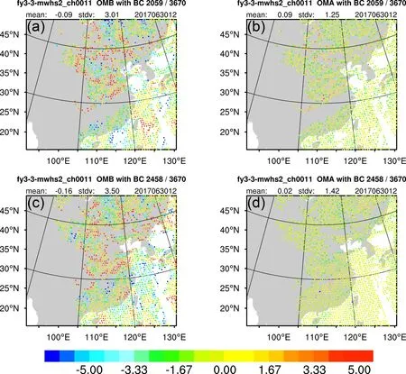
Fig.4.The spatial distributions of OMBs (a, c) and OMAs (b, d) of assimilated observations for channel 11 at 1200 UTC 30 June 2017.The colors of dots represent the values of the OMAs and OMBs (units: K) in CLEARSKY (a, b)and ALLSKY (c, d).
Water vapor transport is essential for large-scale heavy rainfall.Figure 7 shows the 850 hPa water vapor flux distribution pattern at 0000 UTC 30 June 2017 in the fifth generation of ECMWF atmospheric reanalyses of the global climate (ERA5) data, for CONTROL, CLEARSKY, and ALLSKY.As shown in Fig.7a, impacted by the location of the WPSH (red line in Fig.8), water vapor was primarily transported from the South China Sea and the Bay of Bengal to the Yangtze-Huaihe River Basin along the northwest edge of the WPSH.The second vapor branch, from the western Pacific to the Yangtze-Huaihe River Basin, was weaker.Figure 7 shows that there were areas with negative water vapor flux.These areas represent the location of maximum water vapor flux convergence which is known to be favorable for heavy rainfall generation.Figure 7a shows that there were two negative centers of water vapor flux, that is, southeastern Hubei Province and midwestern Guizhou Province.The entire convergence zone of water vapor flux was distributed in a northeast-southwest belt, and CONTROL did not simulate this pattern.On the contrary, CLEARSKY did simulate this northeast-southwest trend without two negative centers.ALLSKY was quite consistent with the ERA5 data,and the trends of the water vapor flux convergence belt and two negative centers were roughly similar (i.e., the simulated negative center position in Hubei Province shifted slightly to the northeast).The convergence of low-level water vapor flux was conducive to rainstorm generation and maintenance, and the area with the maximum negative values was roughly consistent with the location of the maximum precipitation area, as shown in Fig.9c.
The subtropical high is one of the favorable factors for maintaining the mei-yu front (Bi et al., 2004).The intensity and position of the subtropical high greatly affect water vapor transport.The red lines in Figs.8d—f represent the position of the 588-dagpm (the area of the subtropical high) linein the ERA5 data.At the beginning of this precipitation event (Fig.8a; on 28 June 2017), the west-extending point of the subtropical high was located at approximately 110°E,which provided favorable conditions to transport water vapor to the Yangtze-Huaihe River Basin through southwestery winds on the west side of the subtropical high.At the moment of strongest precipitation (Fig.8c; on 30 June 2017), the 588-dagpm line retreated slightly eastward, and the accumulated water vapor reached a maximum.At the end of this precipitation event (Figs.8e, k), the subtropical high retreated to the southeast, deteriorating the favorable water vapor transport conditions.As shown in Figs.8a—c,there was no significant difference in the simulated subtropical high between CONTROL and CLEARSKY.However,positive impacts were gradually achieved in ALLSKY with the 588-dagpm and 152-dagpm lines corresponding to the boundary of the subtropical high and were close to the ERA5 data (Figs.8e, k).Figure 8i represents the 152-dagpm line that characterizes the western Pacific subtropical high at 850 hPa on 30 June 2017, and the wind field is shown in Fig.7.These two figures show that water vapor was transported along the north-western part of the subtropical high.The farther west the subtropical high extended,the more water vapor entered the continent.The water vapor is mainly concentrated at 850 hPa, and a good simulation of the subtropical high helps to accurately simulate water vapor transportation.The subtropical high with the 152-dagpm line in CLEARSKY was the closest to the ERA5 data (yellow line), however, the subtropical high in ALLSKY was far from the ERA5 data.As the integration time increased, ALLSKY performed better in the simulation of subtropical high (Figs.6j—k).Figures 8f and 8l represent the averaged position of the subtropical high with 588-dagpm and 152-dagpm lines over the whole 120 h integration time.In general, there was no significant difference in the simulated position of the subtropical high among CONTROL, CLEARSKY, and ALLSKY, but CLEARSKY performed slightly better than CONTROL and ALLSKY, especially at 850 hPa (Fig.8l).Sufficient water vapor transport and water vapor convergence are the major requirements that caused this precipitation process.

Fig.5.The time series of OMAs (red line) and OMBs (black line) for channel 11 from 0000 UTC 28 June 2017 to 0000 UTC 3 July 2017 in CLEARSKY and ALLSKY (a-b: mean; c-d: standard deviation).
The 24-hour accumulated (from 0000 UTC 28 June 2017 to 0000 UTC 3 July 2017) rainfall distributions calculated from the hourly rain gauges from surface meteorological stations in China are displayed in Fig.9a-e(based on the national meteorological stations from the China Meteorological Administration).Heavy rainfall started to occur on 30 June, with an east-west oriented narrow band of heavy rain (>100 mm) over the middle and lower reaches of the Yangtze River, and the three experiments simulated the increase in rainfall.However, not all the distributions and intensities of the simulated rainfall were close to the observa-tions.The 24-hour accumulated precipitation patterns from 0000 UTC 29 June 2017 to 0000 UTC 30 June 2017 are displayed in Figs.9b (observation), 9g (CONTROL), 9i(CLEARSKY), and 9q (ALLSKY).The rainbands in CONTROL and CLEARSKY were narrower than those in the observations, with less precipitation than the observations to the east and north of the convective line.A broader rain region was achieved in ALLSKY than in the other two experiments, and the distribution of rainbands in ALLSKY was similar to that in the observations.Although these assimilation experiments overestimated the maxima of accumulated precipitation in the southwest part of the rainfall belt, ALLSKY(Figs.9p—s) showed great advantages in rainfall simulation over the first four days by providing precipitation forecasts that were generally consistent with the observations.The trend of the rain belt was northeast-southwest in the observations, but the rain belts in CONTROL (Fig.9h) and CLEARSKY (Fig.9m) were nearly north-south, while the distribution of the rain belt was eastward in ALLSKY (Fig.9r).Although ALLSKY did not capture the stage when rainfall began to weaken on 2 July, which was also reflected in the neutral to negative impacts on the forecast performances of temperature and wind as mentioned above (Figs.6n—o), this experiment produced a positive influence on the simulation of the precipitation process in general.
To quantitatively measure the effectiveness of the rainfall simulation, equitable threat scores (ETS), false alarm rate (FAR), and probability of detection (POD) were calculated.The algorithms are as follows:

N
represents the number of all stations,N
,N
andN
are explained in Fig.10a.There are five days in this precipitation process, the 120-hour rainfall can be divided into five grades: 0—10 mm,10—25 mm, 25—50 mm, 50—100 mm, and 100—250 mm.The ETSs, FARs, and PODs were given for each grade in Fig.10.All scores were calculated for the area that included the whole rainy belt (105°E—123°E, 23°N—34°N).Figure 10ashows the ETSs in CONTROL (the first column),CLEARSKY (the second column), and ALLSKY (the third column).The numbers in boxes represent the scores of ETSs, and the color of the boxes represents the quality ofthese simulations.The higher the ETS score, the more accurate the forecast performance.For the 25—50 mm grade, the ETSs in ALLSKY were 0.35, greater than those in CLEARSKY and CONTROL.Note that for the accumulated precipitation over 25 mm, the ETS in ALLSKY was higher than those in CLEARSKY and CONTROL.Figure 10b shows the FARs in the three experiments.Different from Fig.10a, the higher the FAR score is, the worse the forecast performance.The scores in the third column were higher than those in the first and second columns, indicating that ALLSKY is beneficial for lowering the FAR.Figure 10c is similar to Fig.10a but represents the PODs in the three experiments and illustrates that the PODs in ALLSKY were greatest among the three experiments.These results suggest that the all-sky assimilation approach is better than the clear-sky assimilation and no-assimilation approaches in precipitation forecasting.

Fig.6.The vertical mean RMSEs of relative humidity (a, d, g, j, m, p; units: %), temperature (b, e, h, k, n, q; units: K)and wind (c, f, I, l, o, r; units: m s-1) forecasts versus the ECMWF IFS CY41r2 High-Resolution Operational Forecasts in the CONTROL (red line), CLEARSKY (blue line) and ALLSKY (green line) experiments (a—c: 28 June 2017; d—f: 29 June 2017; g—i: 30 June 2017; j—l: 1 July 2017; m—o: 2 July 2017; p—r: averaged RMSEs over the 120 h integration time).
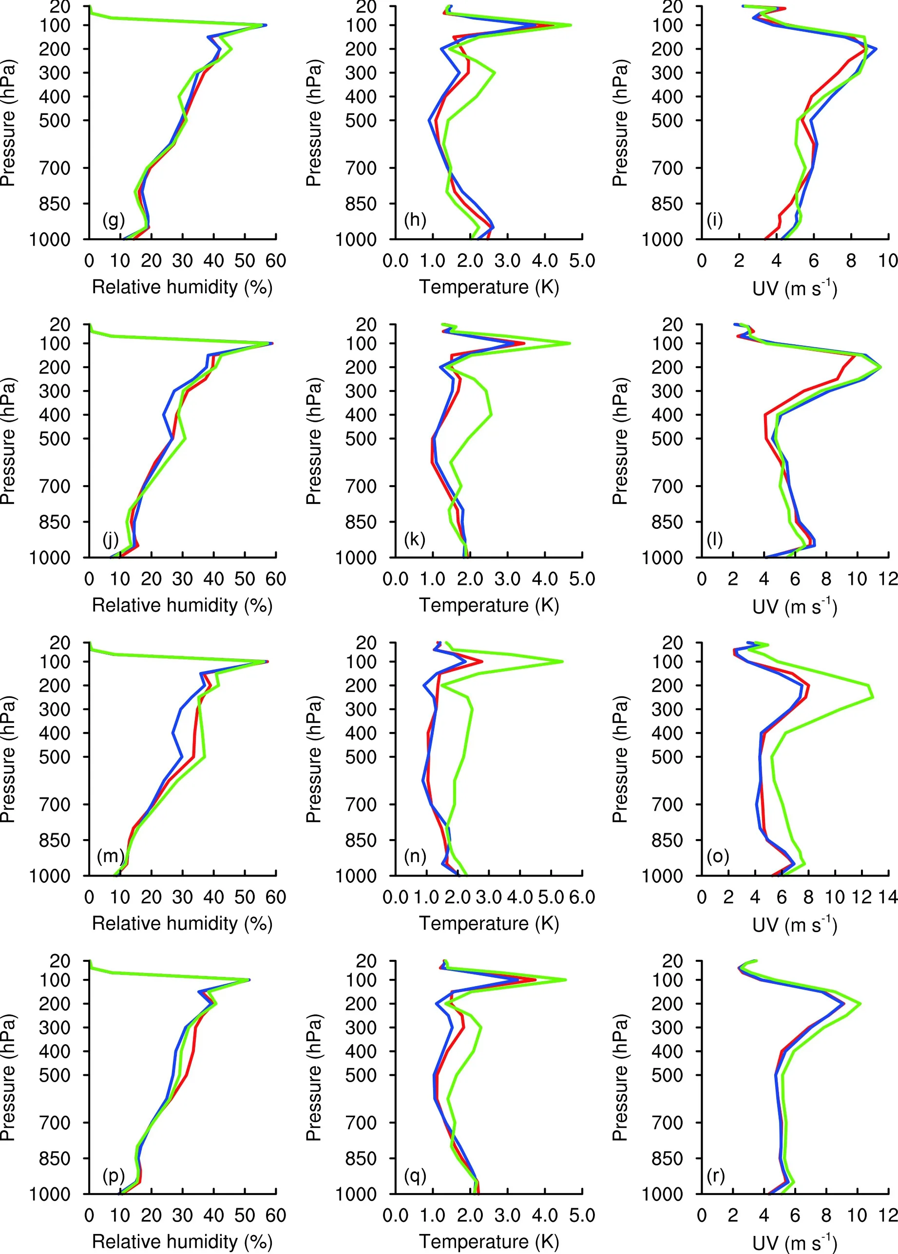
Fig.6.(Continued).

Fig.7.The 850 hPa water vapor flux (units: kg hPa-1 m s-1) and the wind vector (units: m s-1) at 0000 UTC 30 June 2017 in the ERA5 data (a), CONTROL (b), CLEARSKY (c), and ALLSKY (d).
5.Conclusion and discussion
Utilizing microwave data that are sensitive to clouds and rain under all-sky conditions can maximize satellite data usage and improve the quality of initial fields in NWP.Three experiments including a control experiment without assimilating any observations, a clear-sky assimilation, and an all-sky assimilation experiment with only FY-3C/MWHS-2 observations assimilated were set to evaluate the impacts of the all-sky assimilation of FY-3C MWHS-2 on mei-yu rainfall forecasts.Before assimilation, the symmetric error model proposed by Geer and Bauer (2010, 2011)was applied to model the observation error variation with cloud amount, and the PDF of OMBs became a Gaussian distribution, which satisfies the assumption of assimilation theory.Both CLEARSKY and ALLSKY use the microwave window channel (i.e., 89 GHz) to dynamically retrieve the surface emissivity, and the retrieved emissivity shows fewer errors in the area covered by the thick clouds in ALLSKY.The employment of the surface emissivity retrieval in the all-sky approach shows potential in regional models over land.
Over the whole experimental period, the usage rate of FY-3C/MWHS-2 in ALLSKY was higher than that in CLEARSKY (e.g., an extra 14.39% of observations were assimilated in ALLSKY for channel 11), and the extra data were mainly located in thick cloudy areas with abundant clouds and rain.The assimilated ALLSKY with cloud- and rain-contaminated observations had a positive impact on the forecast performance of humidity in the middle-upper troposphere (700—200 hPa), the RMSEs of ALLSKY were smaller than that of CONTROL.But neutral to negative impacts on temperature and wind were reflected as compared with CONTROL and CLEARSKY.The simulated distribution,coverage, and extreme values of water vapor flux were closer to the observations, leading to better performances ofthe qualitative and quantitative forecasts of heavy rainfall.As shown in the 24-hour accumulated precipitation distribution patterns, ALLSKY showed an accurate prediction in the first four days and performed best in forecasting the distribution and intensity of heavy rainfall among the three experiments.Meanwhile, the ETSs, FARs, and PODs showed that CLEARSKY and ALLSKY are both beneficial for rainfall forecasting.This is especially true for ALLSKY which improved the forecasting of moderate rain and above.In general, the assimilation of FY-3C/MWHS-2 observations under all-sky conditions has positive impacts on the forecast of mei-yu rainfall.This will provide a new solution for the forecast of mei-yu precipitation, which is good for reducing the loss of life and property caused by heavy rains.
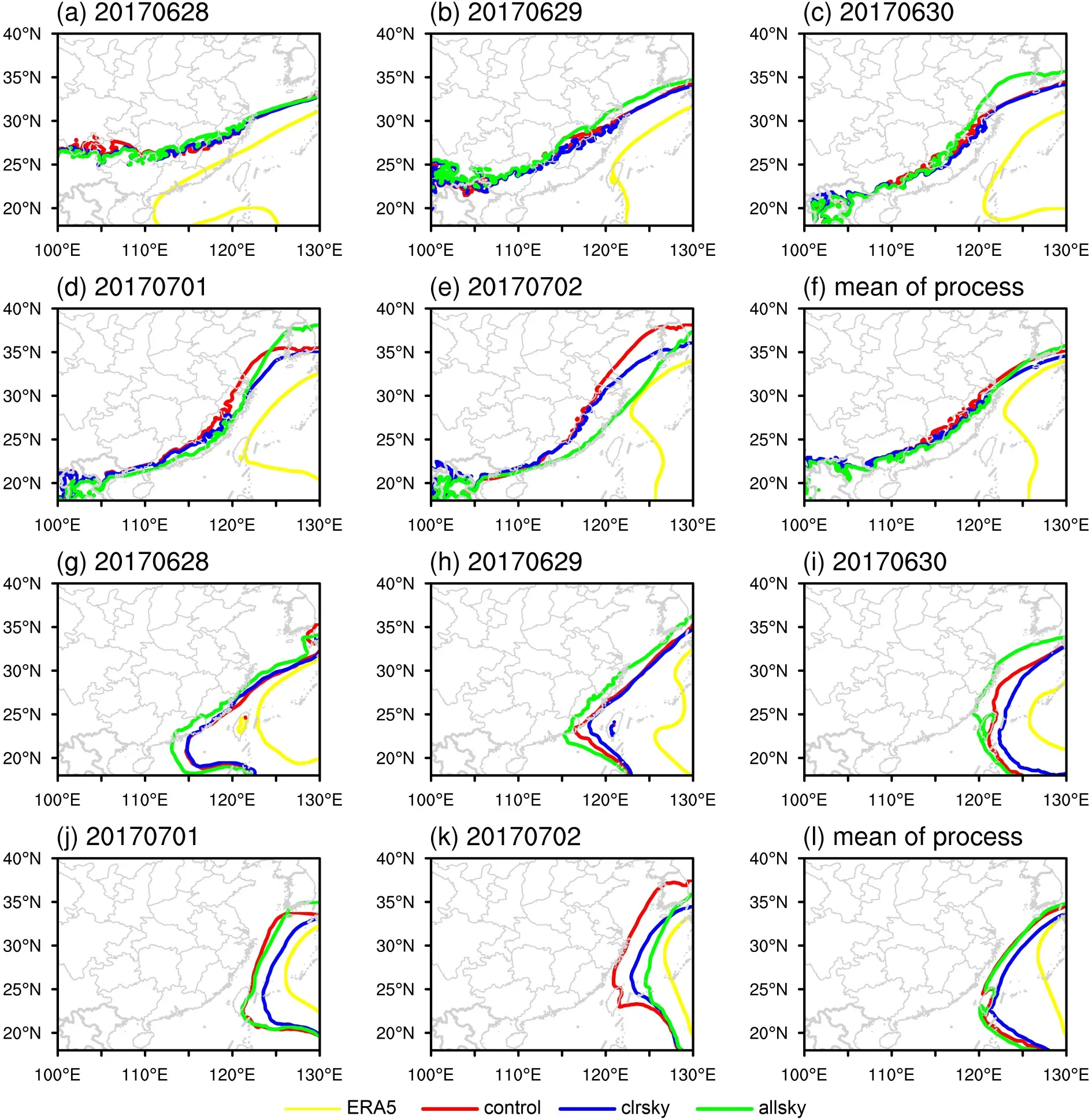
Fig.8.The areas with characteristic lines of the WPSH on 28 June (a, g), 29 June (b, h), 30 June (c, i), 1 July(d, j), 2 July (e,k) and averaged over the 120 h integration time (f, l) (a—f: 850 hPa; g—l: 500 hPa; yellow line: ERA5 data; red line:CONTROL; blue line: CLEARSKY; green line: ALLSKY).
Note that in this study the impact of all-sky assimilation was not be measured on top of a baseline of observations which is typical of operational weather forecasting.On the other hand, ALLSKY did not accurately simulate the stage when rainfall began to weaken (Fig.9t); in contrast,only CLEARSKY and CONTROL captured this process(Figs.9j, o).There may be various reasons for this, and there will be some approaches to improve the forecast performances in the future.Firstly, more advanced data assimilation methods or systems will be an available approach.The 3D-VAR scheme used in this study could not update the background errors for long-term data assimilation cycles;however, more advanced methods, such as 4D-VAR or the hybrid (incorporating ensemble-produced background errors in the variational framework) method, could provide flow-dependent background errors and improve the quality of analysis.In addition, the system used to conduct all-sky assimilation is far from state-of-art, which is only able to adjust control variables for the moisture, wind, and temperature-related variables, in the presence of clouds, but does not benefit directly from cloud or precipitation information.This may be the reason why ALLSKY achieved neutral to negative impacts on the forecast performances for temperature and wind.Hydrometeors (i.e., cloud liquid water, cloud ice, rain, snow, and graupel) will be added as control variables in the all-sky framework to make good use of cloudand rain-affected radiances.Tong et al.(2020) carried out a study to assess the impact of this newly constructed all-sky framework on weather forecasts in the Finite-Volume Cubed-Sphere Dynamical Core Global Forecast System,which has been selected as the next-generation global and regional forecast system at NCEP.This new all-sky framework produces neutral to positive impacts on the overall forecast skill, which provides an approach to improve the forecast performance by adding hydrometeors to the WRFDA system.Last but not least, channels 8, 9, 13, and 14 with abundant humidity and temperature information were not assimilated in this study because of the large observation errors.Channels 8 and 9 are sensitive to the surface and will be treated as microwave imagers, as discussed in Lawrence et al.(2018).How to suitably assimilate observation data using these channels is worthy of future research.
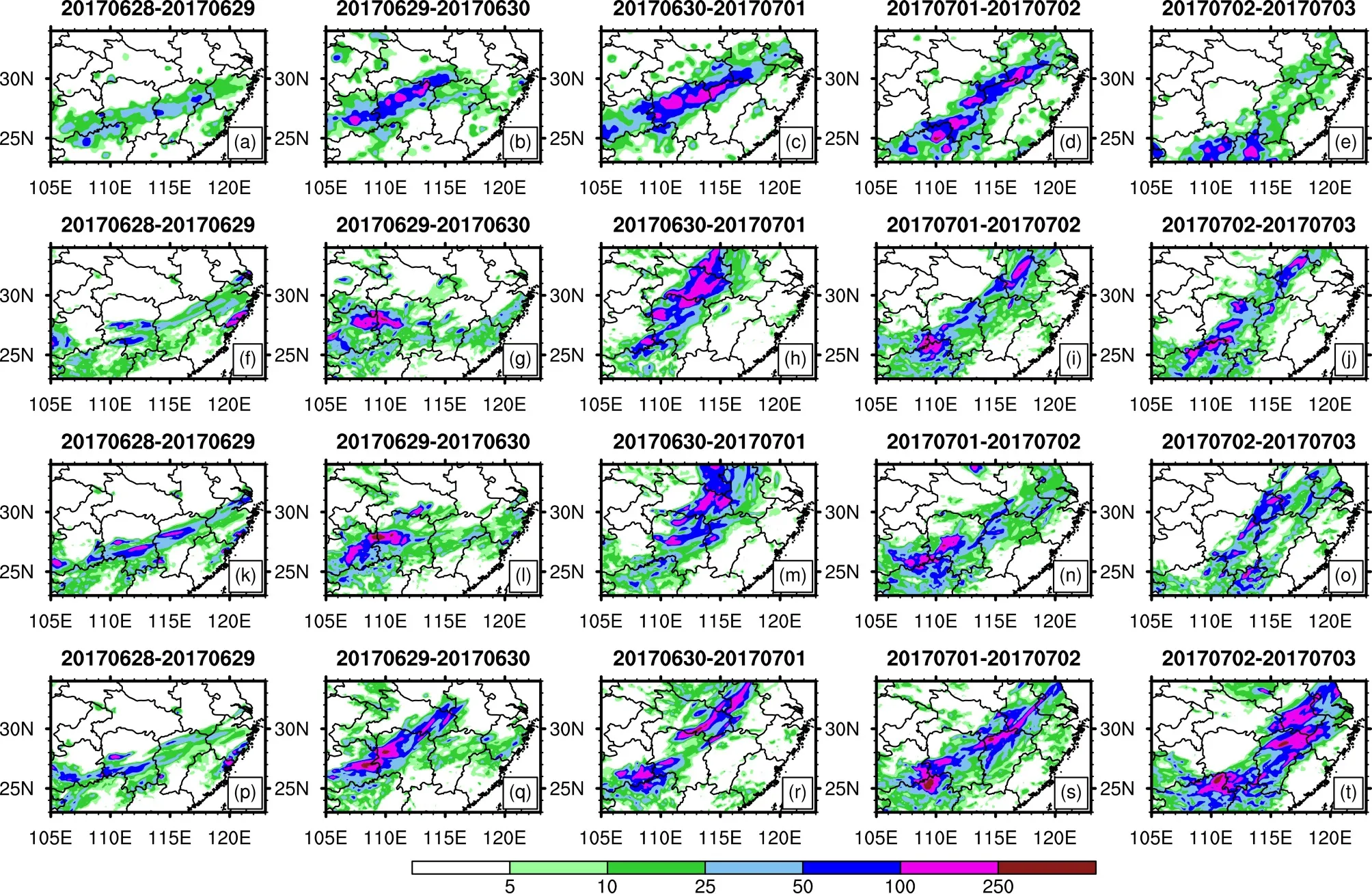
Fig.9.The 24-hour accumulated precipitation (units: mm) over the middle and lower reaches of the Yangtze River from 0000 UTC 28 June 2017 to 0000 UTC 3 July 2017 from observation (a, b, c, d, e), CONTROL (f, g, h, i, j), CLEARSKY (k, l, m, n, o), and ALLSKY (p, q, r, s, t) experiments.
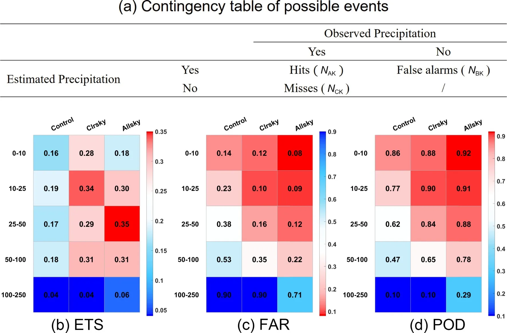
Fig.10.The ETSs (a), FARs (b), and PODs (c) of 120-hour accumulated precipitation from 0000 UTC 28 June to 0000 UTC 3 July in CONTROL (the first column), CLEARSKY (the second column), and ALLSKY (the third column) for five grades (0—10 mm, 10—25 mm, 25—50 mm, 50—100 mm, 100—250 mm).
Acknowledgments.The authors would like to thank the two anonymous reviewers whose suggestions greatly helped to improve and clarify this manuscript.In addition, the National Natural Science Funds of China (Grant No.41875039) and the Fengyun-3 meteorological satellite ground application system project, and the development of the application software for southwest regional road traffic using the Fengyun-3 satellite remote sensing monitoring service (Grant No.ZQC-J19193) are also appreciated to support this research.The FY radiance data were obtained freely from http://fy3.satellite.cma.gov.cn.The ECMWF IFS CY41r2 High-Resolution Operational Forecasts and ERA5 data can be downloaded from (https://rda.ucar.edu/datasets/ds113.1/)and (https://cds.climate.copernicus.eu/cdsapp#!/dataset/reanalysisera5-pressure-levels?tab=form), respectively.The precipitation observations can be obtained from (https://data.cma.cn/data/cdcdetail/dataCode/A.0012.0001.html).
杂志排行
Advances in Atmospheric Sciences的其它文章
- Preface to the Special Issue on Fengyun Meteorological Satellites:Data, Application and Assessment
- The First Fengyun Satellite International User Conference
- Use of Microwave Radiances from Metop-C and Fengyun-3 C/D Satellites for a Northern European Limited-area Data Assimilation System
- Insights into the Microwave Instruments Onboard the Fengyun 3D Satellite: Data Quality and Assimilation in the Met Office NWP System
- Rainfall Algorithms Using Oceanic Satellite Observations from MWHS-2
- Water Vapor Retrievals from Near-infrared Channels of the Advanced Medium Resolution Spectral Imager Instrument onboard the Fengyun-3D Satellite
