Different Configurations of Interannual Variability of the Western North Pacific Subtropical High and East Asian Westerly Jet in Summer
2021-06-04XinyuLIRiyuLUandGenLI
Xinyu LI, Riyu LU, and Gen LI
1Key Laboratory of Marine Hazards Forecasting, Ministry of Natural Resources, Hohai University, Nanjing 210098, China
2College of Oceanography, Hohai University, Nanjing 210098, China
3State Key Laboratory of Numerical Modeling for Atmospheric Sciences and Geophysical Fluid Dynamics,Institute of Atmospheric Physics, Chinese Academy of Sciences, Beijing 100029, China
4College of Earth and Planetary Sciences, University of the Chinese Academy of Sciences, Beijing 100049, China
ABSTRACT
Key words:western North Pacific subtropical high, East Asian westerly jet, circulation, rainfall, sea surface temperature
1.Introduction
The western North Pacific subtropical high (WNPSH)in the lower troposphere and the East Asian westerly jet(EAJ) in the upper troposphere are two dominant components of East Asian summer monsoon systems (e.g., Tao and Chen, 1987; Ding, 1992; Huang et al., 2003; Lu, 2004; Tao and Wei, 2006). The zonal shift of the WNPSH is the leading mode of lower-tropospheric horizontal wind variability on the interannual timescale (Lu, 2001; Wang et al., 2001),and the meridional displacement of the EAJ acts as the leading mode of upper-tropospheric zonal wind variability (Lin and Lu, 2005; Li and Lin, 2015). It has been well documented that both leading modes play a crucial role in affecting the East Asian summer climate (Kurihara and Tsuyuki,1987; Liang and Wang, 1998; Lu, 2001; Xuan et al., 2011;Li and Zhang, 2014; Wang and Zhang, 2015; Li and Lu,2017, 2018; Yan et al., 2019; Zhang et al., 2020).
There is a significant correspondence between the zonal shift of the WNPSH and the meridional displacement of the EAJ, that is, the westward extension (eastward retreat) of the WNPSH is closely associated with the southward (northward) shift of the EAJ (Wang et al., 2001; Lu, 2004; Lu and Lin, 2009; Li and Lu, 2020). The interannual variations of the WNPSH and EAJ are closely associated with the anomalous convection and/or precipitation over the tropical western North Pacific (WNP) (Lu, 2001; Lu and Dong, 2001).Suppressed (enhanced) precipitation over the tropical WNP induces an anticyclonic (cyclonic) anomaly in the lower troposphere to the northwest, which corresponds to the westward extension (eastward retreat) of the WNPSH and the southward (northward) displacement of the EAJ. On the other hand, the anticyclonic (cyclonic) anomaly is favorable for enhanced (suppressed) precipitation along the subtropical East Asian rainy belt, including the Yangtze River basin, by affecting moisture transport (Huang and Sun, 1992; Wang et al., 2001; Zhou and Yu, 2005; H. Li et al., 2019; X. Z. Li et al., 2019). A southward (northward) displaced EAJ also favors enhanced (reduced) subtropical rainfall (Liang and Wang, 1998; Lu, 2004; Xuan et al., 2011; Li and Zhang,2014; Li and Lu, 2017; Yan et al., 2019). Both the WNPSH-EAJ relationship and subtropical rainy belt are components of the well-known meridional teleconnection over the WNP and East Asia (WNP-EA), i.e., the Pacific-Japan pattern (Nitta, 1987) or East Asia-Pacific pattern (Huang and Sun, 1992).
It has been well reported that the tropical sea surface temperature (SST) anomalies, especially the evolution of El Niño-Southern Oscillation (ENSO), play an important role in affecting the WNPSH and EAJ. During the mature phase of El Niño, an anticyclonic anomaly develops over the tropical WNP. This anticyclonic anomaly can be maintained into the following summer through local air-sea interactions (Wang et al., 2003) or the Indian Ocean capacitor effect (Terao and Kubota, 2005; Yang et al., 2007; Li et al.,2008; Xie et al., 2009; Yun et al., 2013; Xie et al., 2016),and corresponds to the westward extension of the WNPSH and southward shift of the EAJ. The tropical, summer SSTs which occur simultaneously also affect the WNPSH and EAJ. For instance, the SST warming (cooling) over the tropical central and eastern Pacific in summer favor more (less)rainfall over the tropical WNP and thus a cyclonic (anticyclonic) anomaly to the northwest (Lau and Nath, 2006; Wang et al., 2013). Besides, these SST anomalies can induce homogenous tropospheric warming (cooling) in the tropics, and the associated thermal wind leads to the meridional shift of the mid-latitude jet (Held and Hou, 1980; Bretherton and Sobel, 2003; Seager et al., 2003; Chen et al., 2008; Lu et al.,2008; Lin and Lu, 2009; Lin, 2010; Sun et al., 2013; Kong and Chiang, 2020).
Although there are tropical-extratropical connections over the WNP-EA, the meridional shift of the EAJ is not forced entirely by tropical heating. In particular, it is not guaranteed that the westward extension (eastward retreat) of the WNPSH will always correspond to the southward (northward) shift of the EAJ. That is, in some years, a westward extended WNPSH may co-exist with a northward displaced EAJ, or an eastward retreated WNPSH may co-exist with a southward displaced EAJ. While focusing on the anomalies associated with individual WNPSH and EAJ, previous studies ignored the configurations of the WNPSH and EAJ. Hereafter, these two configurations, i.e., the general and uncommon ones, are called in-phase and out-of-phase configurations, respectively. The anomalies of different WNPSHEAJ configurations, especially the out-of-phase configuration, are necessary supplements to the well-known tropical-extratropical connections over WNP-EA. Furthermore, we will investigate the possible mechanism for the occurrence of different configurations, focusing on the roles of tropical SSTs. Recently, Li and Lu (2020) reported that the simultaneous summer SST cooling in the tropical central and eastern Pacific results in the absence of WNPSHEAJ correspondence after the early 2000s, in sharp contrast to the previously well-known phenomenon, i.e., the decay of El Niño favors the westward extension of the WNPSH and southward shift of the EAJ. These results suggest that tropical SSTs may affect different configurations of the WNPSH and EAJ on interannual timescales, which is also to be tested in this study.
The rest of this paper is organized as follows. Section 2 describes the data, indices, and methods used in this study.In section 3, we investigate the circulation and precipitation anomalies associated with different configurations of the WNPSH and EAJ. Section 4 further explores the role of evolving tropical SSTs in affecting the WNPSH-EAJ correspondences. Section 5 provides a summary.
2.Data, indices and methods used
This study uses the monthly Japanese 55-Year Reanalysis (JRA-55; Kobayashi et al., 2015) data, with a horizontal resolution of 1.5° × 1.5°. Also employed is the monthly land rainfall data from the Climatic Research Unit(CRU) high-resolution dataset, which is based on the weather station record (version 4.04; Harris et al., 2014)with a horizontal resolution of 0.5° × 0.5°. In addition, the National Oceanic and Atmospheric Administration (NOAA)extended reconstructed SST data (version 5) are also used.The horizontal resolution of the SST data is 2.0° × 2.0°. All the datasets used in the present study are monthly mean data selected from 1958 to 2019. In this study, we focus on the summer mean, which refers to the averages over June-August (JJA).
The main statistical methods used in the present study include composite, regression, and correlation analyses. A Student’s t-test is used to determine the statistical significance of the analyzed results.
3.Anomalies associated with the in-phase and out-of-phase configurations of the WNPSH and EAJ
Figure 1 shows the scatter diagram of standardized WNPSHI and EAJI. In general, there is a positive relationship between the WNPSHI and EAJI. The correlation coefficient between the WNPSHI and EAJI is 0.37, which is significant at the 95% confidence level. This indicates that the westward extension (eastward retreat) of the WNPSH is closely associated with the southward (northward) shift of the EAJ, which is consistent with several previous studies(e.g., Lau et al., 2000; Lu, 2004; Li and Lu, 2017). Note that the EAJI clearly increases when the WNPSHI is negative(the second and third quadrants) but the increase is less robust when the WNPSHI is positive (the first and fourth quadrants), which suggests an asymmetric relationship between the WNPSH and EAJ (Lu et al., 2016). The correlation coefficient between the WNPSHI and EAJI is 0.41 when the WNPSHI is negative, which is statistically significant at the 95% confidence level; and it reduces to 0.24 when the WNPSHI is positive.
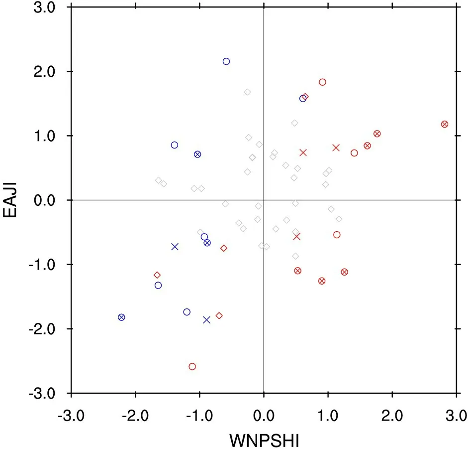
Fig. 1. Scatter diagram of the standardized WNPSHI(abscissa) and EAJI (ordinate) during 1958-2019. Red and blue cases indicate the years in which the absolute values of WNPSHI and EAJI are both greater than 0.5 standard deviations from the mean. The red (blue) circles represent the decaying (developing) year of El Niño; red (blue) cross denotes the developing (decaying) year of La Niña, and the red(blue) circle-cross indicates the year with both El Niño (La Niña) decaying and La Niña (El Niño) developing. ENSO decaying or developing years are identified according to the generally-accepted criterion that the three-month running mean of SSTs in the Niño-3.4 region (5°S-5°N, 170°-120°W)exceeds the threshold of ±0.5°C for a minimum of five consecutive overlapping seasons (http://www.cpc.ncep.noaa.gov/products/analysis_monitoring/ensostuff/ensoyears.shtml).
The scatter diagram divides all the samples into four categories, i.e., two in-phase configurations (WNPSHI+ EAJI+and WNPSHI− EAJI−) and two out-of-phase configurations (WNPSHI+ EAJI− and WNPSHI− EAJI+). We choose the years in which the absolute values of WNPSHI and EAJI are both greater than 0.5 standard deviations and perform composite analyses based on these years. This criterion yields nine (WNPSHI+ EAJI+) cases, three(WNPSHI− EAJI+) cases, 11 (WNPSHI− EAJI−) cases,and five (WNPSHI+ EAJI−) cases, respectively (Fig. 1). It was found that the circulation, precipitation, and SST anomalies are basically anti-symmetric between the two in-phase configurations, and also between the two out-of-phase configurations (not shown). Therefore, the composite difference between the two in-phase and that between the two out-ofphase configurations (i.e., WNPSHI+ EAJI+ minus WNPSHI− EAJI− and WNPSHI+ EAJI− minus WNPSHI−EAJI+) are used to represent the in-phase and out-of-phase anomalies, respectively. The in-phase and out-of-phase configurations are both associated with positive WNPSHI, but positive and negative EAJI, respectively.
In addition, to make comparisons between the WNPSH-EAJ configurations and those associated with the individual WNPSH or EAJ, we also select the cases with the absolute values of WNPSHI or EAJI greater than 0.5 standard deviations and perform composite analyses based on these cases. There are 20 WNPSHI+ cases, 20 WNPSHI− cases, 21 EAJI+ cases, and 19 EAJI− cases selected. The composite difference between the WNPSHI+ and WNPSHI− cases and that between the EAJI+ and EAJI−cases are used to represent the anomalies associated with individual WNPSHI and EAJI, respectively.
3.1.Circulation anomalies
Figure 2 shows the 850-hPa horizontal wind anomalies(UV850) associated with the in-phase and out-of-phase configurations of the WNPSHI and EAJI, respectively. For the in-phase configuration (Fig. 2a), there is a significant anticyclonic anomaly over the subtropical WNP, suggesting a westward extension of the WNPSH. A cyclonic anomaly appears over the mid-latitudes of East Asia, in association with the southward shift of the upper-tropospheric EAJ (Li and Lu, 2017). In addition, there is another anticyclonic anomaly over Northeast Asia. These circulation anomalies manifest themselves as the meridional teleconnection over WNP-EA (Huang and Sun, 1992; Lu and Lin, 2009;Kosaka et al., 2011). In contrast, the UV850 anomalies associated with the out-of-phase configuration show distinctly different features (Fig. 2b). There is still an anticyclonic anomaly over the subtropical WNP, however, this anticyclonic anomaly extends more northward and occupies a much larger meridional scope. Associated with this anticyclonic anomaly, there are southwesterly and westerly anomalies in North China and central Japan, which is associated with a northward shift of the upper-tropospheric EAJ.
The UV850 anomalies induced by the in-phase and outof-phase configurations resemble those associated with the first and second EOF modes associated with the East Asian summer monsoon (Sun et al., 2010; Greatbatch et al., 2013;Ding et al., 2014, 2015; Li et al., 2018), respectively, suggesting that different configurations of the WNPSH and EAJ dominate the lower-tropospheric circulation anomalies over the WNP-EA. Additionally, these UV850 anomalies also show great similarities with the circulation anomalies that contribute to the predictability and unpredictability of the meridional teleconnection in climate models, respectively (Lin et al., 2018), suggesting that the out-of-phase configuration contributes to the uncertainty in this regard.

Fig. 2. The 850-hPa horizontal wind anomalies (UV850; units: m s−1) associated with the (a) in-phase and (b) out-ofphase configurations of the WNPSHI and EAJI, respectively. Cases with the absolute values of WNPSHI and EAJI both greater than 0.5 standard deviations from the mean are used. The anomalies here refer to the composite difference between the two in-phase configurations and that between the two out-of-phase configurations, i.e.,WNPSHI+ EAJI+ minus WNPSHI− EAJI− and WNPSHI+ EAJI− minus WNPSHI− EAJI+, respectively. “AC” and“C” represent the anticyclonic and cyclonic anomaly, respectively. The difference in area-averaged, JJA-mean 850-hPa zonal winds between the two marked regions in (a) is used to define the WNPSHI (see text for details). Shadings indicate that either the zonal or meridional wind anomalies are significant at the 95% confidence level based on a Student’s t-test.

Fig. 3. Same as Fig. 2, but for the 200-hPa zonal wind anomalies. The contour interval is 2.0 m s−1, and zero contours are omitted. The difference in area-averaged, JJA-mean 200-hPa zonal winds between the two marked regions in (a) is used to define the WNPSHI (see text for details). The bold black lines represent the climatological jet axis. Here, the jet axis is determined based upon the first derivative of zonal winds being zero. Shadings indicate that the zonal wind anomalies are significant at the 95% confidence level based on a Student’s t-test.
Figure 3 shows the 200-hPa zonal wind (U200) anomalies associated with the in-phase and out-of-phase configurations of the WNPSHI and EAJI, respectively. For both the in-phase and out-of-phase configurations, there are westerly anomalies in the tropical WNP (Figs. 3a and 3b), which act as the upper-tropospheric counterpart of the easterly anomalies along the south flank of the lower-tropospheric anticyclonic anomaly (Figs. 2a and 2b). On the other hand, the extratropical anomalies are distinctly different between the in-phase and out-of-phase configurations. For the in-phase cases (Fig. 3a), there are positive anomalies to the south of the jet axis and negative anomalies to the north, indicating a southward displacement of the jet. The U200 anomalies are characterized by a typical meridional teleconnection from the tropics to the extratropics over the WNP-EA. However,for the out-of-phase cases (Fig. 3b), there are easterly anomalies to the south of the jet axis and westerly anomalies to the north, indicating a northward shift of the jet. These results indicate that the circulation anomalies associated with the in-phase and out-of-phase configurations of the WNPSH and EAJ are distinctly different.
哈尔滨分公司呼兰片区的利民加油站位于乡镇,在地理位置上没什么独特的优势,因为附近的农户比较少,最近也要15公里或者20公里的距离。这样的距离中间不乏有诸多社会加油站。“利民站根据每个月的销量、利润情况,再根据周边社会加油站让利情况,有时采取挂牌直降的措施。”利民加油站经理范好光说,但这样的优惠力度不会太大,一般每升在0.1元~0.5元之间。
The circulation anomalies associated with the in-phase configuration are similar to those associated with the individual WNPSHI or EAJI (Fig. 4), which exhibit as a meridional teleconnection pattern in both the lower and upper troposphere and have been well documented by previous studies(e.g., Wang and Fan, 1999; Zhang et al., 2003; Lu and Lin,2009; Zhao et al., 2015). However, the anomalies for the inphase configuration are stronger and more significant. For instance, the composite difference of WNPSHI between the two in-phase configurations is 5.09 m s, but only 1.76 m sbetween the EAJI+ and EAJI− cases. The composite difference of EAJI between the two in-phase configurations is 10.91 m s, greater than that between the WNPSHI+ and WNPSHI− cases (3.88 m s). On the other hand, compared to the individual WNPSHI or EAJI, the tropical WNP anticyclonic anomaly for the out-of-phase WNPSHI-EAJI configuration extends more northward (Fig. 2b). This is because the northward shift of the EAJ corresponds to an anticyclonic anomaly in the mid-latitudes of East Asia in the lower troposphere (Li and Lu, 2017), which merges with the one associated with the westward extension of the WNPSH.
3.2.Rainfall anomalies
Figure 5 shows the East Asian rainfall anomalies associated with the in-phase and out-of-phase configurations of the WNPSHI and EAJI, respectively. For the in-phase configuration, rainfall increases significantly over the Yangtze River basin and south Japan and decreases in North China and Northeast Asia (Fig. 5a). However, enhanced rainfall moves northward into North China and the northern Korean Peninsula for the out-of-phase cases (Fig. 5b), corresponding to the northward expansion of the WNP anticyclonic anomaly (Fig. 2b). In addition, rainfall over the Yangtze River basin and south Japan is suppressed for the out-ofphase configuration (Fig. 5b).
Rainfall anomalies associated with the individual WNPSHI and EAJI show great similarities to the in-phase configuration, i.e., there are enhanced anomalies over the Yangtze River basin and South Japan and suppressed anomalies over Northeast Asia (Figs. 6a and 6b), consistent with previous studies (e.g., Wang and Fan, 1999; Zhang et al.,2003; Lu and Lin, 2009; Zhao et al., 2015). However, compared to the individual WNPSHI or EAJI, the anomalies are more intense for the in-phase configuration. For instance,the rainfall anomalies averaged over the Yangtze River basin (27°-34°N, 105°-122°E) for the in-phase configuration are 1.27 mm d, stronger than those for the individual WNPSHI (0.74 mm d) or EAJI (0.98 mm d). Therefore,the in-phase configuration of the WNPSH and EAJ supports weather patterns that are more prone to both floods and droughts over the Yangtze River basin and south Japan.On the other hand, the southward shift of the EAJ results in suppressed rainfall over North China and the northern Korean Peninsula (Fig. 6b). However, compared to the individual effect of the EAJ, an out-of-phase WNPSH-EAJ configuration induces stronger rainfall anomalies over North China and the northern Korean Peninsula: rainfall anomalies averaged over (36°-42°N, 110°-128°E) are 1.15 mm dfor the out-of-phase configuration, but only −0.72 mm dfor the individual EAJI.

Fig. 4. Same as Figs. 2 and 3, but for (a, c) WNPSHI+ minus WNPSHI− and (b, d) EAJI+ minus EAJI− cases,respectively. The contour interval in (c) and (d) is 1.0 m s−1, and zero contours are omitted.

Fig. 5. Same as Fig. 2, but for CRU rainfall anomalies (units: mm d−1). The marked regions in (a) indicate the Yangtze River basin and south Japan, respectively, and the one in (b) represents North China and the northern Korean Peninsula. Hatching indicates that the anomalies are significant at the 95% confidence level based on a Student’s t-test.
4.Role of tropical SSTs
In this section, we explore the role of the tropical SST evolution in supporting different configurations of the WNPSH and EAJ. Figure 7 shows the evolution of tropical SST anomalies associated with the in-phase and out-ofphase configurations of the WNPSHI and EAJI, respectively. The SSTs for the in-phase configuration are weak and show marginal significance (left-hand panels of Fig. 7). The tropical SSTs seem to be characterized by the decaying phase of El Niño and the developing phase of La Niña,which resemble those for the individual WNPSHI (left-hand panels of Fig. 8). However, compared to the individual WNPSHI, the SSTs for the in-phase configuration are weaker. For instance, the SSTs averaged over the Niño-3 region in the previous (following) winter are 0.91°C(−1.09°C) for the WNPSHI, but only 0.86°C (−0.78°C) for the in-phase configuration. Besides, the El Niño-to-La Niña transition is slower for the in-phase configuration and there are overall positive SSTs in the tropics that occur simultaneously in summer (Fig. 7e). The weak tropical SSTs for the in-phase configuration are consistent with the notion that the tropical-extratropical connections over WNP-EA can be self-sustained without external SST forcing (Kosaka and Nakamura, 2006). In other words, the SST forcing is not a necessity for the occurrence of the in-phase configuration.
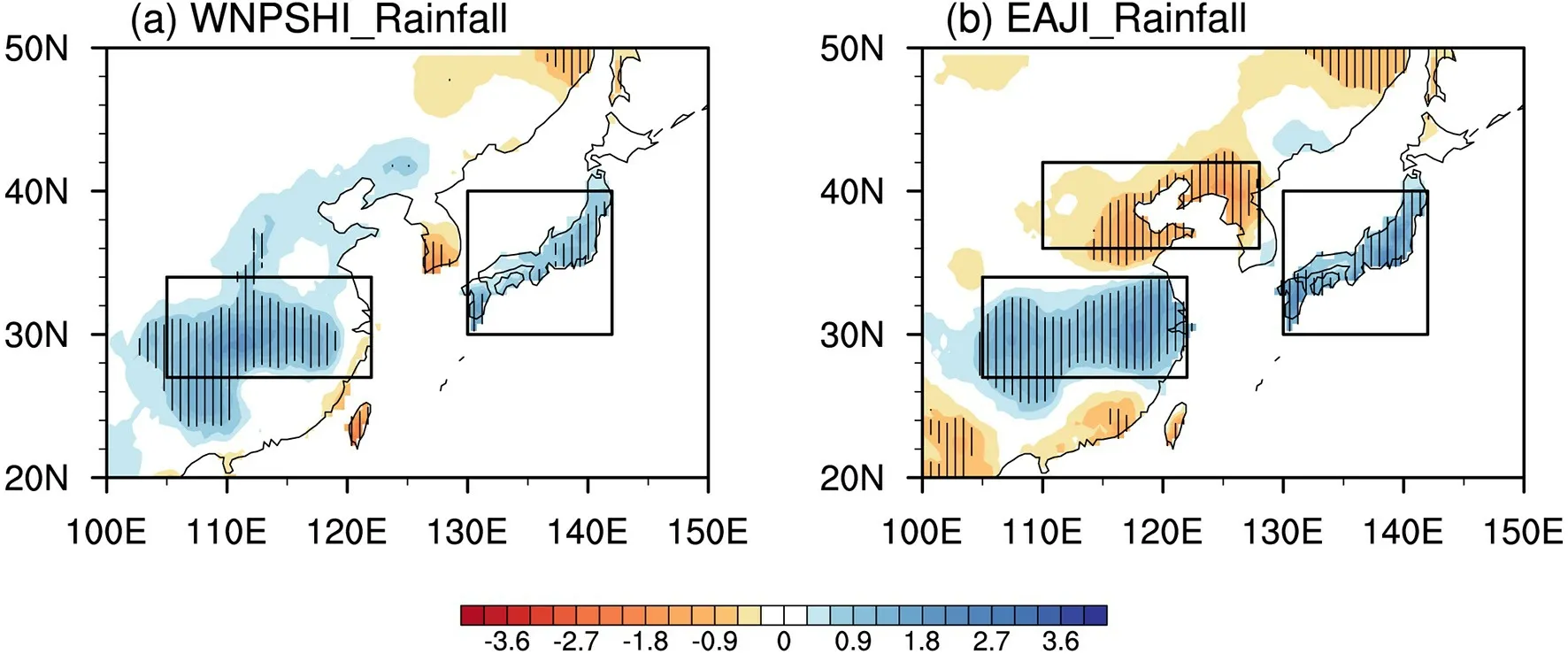
Fig. 6. Same as Fig. 5, but for (a) WNPSHI+ minus WNPSHI− and (b) EAJI+ minus EAJI− cases, respectively.

Fig. 7. Evolution of sea surface temperature (SST) anomalies (units: °C) from the preceding (−DJF) to subsequent(+DJF) winter associated with the (left-hand panels) in-phase and (right-hand panels) out-of-phase configurations of the WNPSHI and EAJI, respectively. Zero contours are omitted. Hatching indicates that the SST anomalies are significant at the 95% confidence level based on a Student’s t-test. Marked regions in (a) and (j) are used to define the Niño-3 index in the preceding and the following winters, respectively.
In contrast, the out-of-phase configuration shows strong and significant negative SSTs in the tropical central and eastern Pacific in simultaneous summer (Fig. 7f), and these anomalies develop further into the following seasons(Figs. 7h and 7j), i.e., the developing phase of La Niña.Among the five WNPSHI+ EAJI− cases, four are consistent with the developing phase of La Niña, yet all the three WNPSHI− EAJI+ cases are associated with the developing phase of El Niño (Fig. 1). The negative SSTs in the tropical central and eastern Pacific in summer are favorable for the WNP anticyclonic anomaly and the northward shift of the EAJ (Lau and Nath, 2006; Lin and Lu, 2009; Lin, 2010;Wang et al., 2013; Kong and Chiang, 2020). In addition,there are negative SSTs in the tropical Indian ocean, which may also contribute to the northward shift of the EAJ (Qu and Huang, 2011).

Fig. 8. Same as Fig. 7, but for (left-hand panels) WNPSHI+ minus WNPSHI− and (right-hand panels) EAJI+ minus EAJI− cases, respectively.
Compared to the individual WNPSHI, as well as the inphase configuration, the SSTs for the out-of-phase configuration are much stronger in summer and the following seasons. For instance, the SSTs averaged over the Niño-3 region in the following winter are −1.30°C for the out-ofphase configuration, but only −0.58°C for the individual WNPSHI. These results suggest that the out-of-phase configuration of the WNPSH and EAJ requires strong external SST forcing during the summer and into the following seasons. It is also notable that the tropical SST evolution is largely anti-symmetric between the two out-of-phase configurations (not shown). That is, the out-of-phase configuration could also be associated with the developing phase of El Niño, but with opposite-signed circulation anomalies.
Figure 9 shows the JJA-mean UV850 and U200 anomalies regressed onto the normalized Niño-3 index from the previous winter and again upon the negative Niño-3 index of the following winter. Note that the following winter Niño-3 index here is multiplied by -1 to obtain the anomalies associated with the developing phase of La Niña. The UV850 anomalies associated with the decay of El Niño are characterized by a significant anticyclonic anomaly over the subtropical WNP (Fig. 9a) and a cyclonic anomaly over the mid-latitudes of East Asia, which is in association with a southward shift of the upper-tropospheric EAJ (Fig. 9c). In addition,the U200 anomalies appear to demonstrate a meridional teleconnection from the tropical to extratropical WNP-EA(Fig. 9c). These anomalies are similar to those associated with the in-phase configuration of the WNPSH and EAJ(Figs. 2a and 3a).

Fig. 9. Regression of (a, b) 850-hPa horizontal winds (vectors; units: m s−1) and (c, d) 200-hPa zonal winds(contours; units: m s−1) upon the normalized (a, c) Niño-3 index of the previous winter and (b, d) upon the negative Niño-3 index of the following winter during 1958-2019. Shadings in (a) and (b) indicate that either the zonal or meridional wind anomalies are significant at the 95% confidence level based on a Student’s t-test. “AC” and “C”represent the anticyclonic and cyclonic anomaly, respectively. The contour interval in (c) and (d) is 0.3 m s−1, and zero contours are omitted. The bold black lines represent the climatological jet axis. Shadings in (c) and (d) indicate that the zonal wind anomalies are significant at the 95% confidence level based on a Student’s t-test.
By contrast, for the developing phase of La Niña(Fig. 9b), which is accompanied by negative SSTs in tropical central and eastern Pacific in summer, there are also anticyclonic anomalies over the subtropical WNP. However,the mid-latitude cyclonic anomaly is absent. Instead, there is an anticyclonic anomaly over north Japan, which corresponds to the northward shift of the upper-tropospheric EAJ(Fig. 9d). The southerly anomalies on the western flank of the anticyclonic anomaly over north Japan merge with those associated with the subtropical WNP anticyclonic anomaly and result in southwesterly or southeasterly anomalies throughout eastern China. These anomalies are in good agreement with previous results (e.g., Wu et al., 2003; Wu et al.,2009; Li et al., 2014; Wen et al., 2019) and show some similarities with the out-of-phase configuration of the WNPSH and EAJ (Fig. 2b). The correlation coefficient between the JJA-mean Niño-3 index and the WNPSHI (EAJI) is −0.26(0.29), which is statistically significant at the 95% confidence level. These results suggest that the developing phase of La Niña is favorable for the out-of-phase WNPSH-EAJ correspondence.
There are similarities and discrepancies between the interannual variation and decadal change of the WNPSH-EAJ relationship in the early 2000s (Li and Lu, 2020). For instance,the in-phase configuration and the close WNPSH-EAJ relationship before the early 2000s are both characterized by the meridional teleconnection and tend to be associated with the decay of El Niño; and the out-of-phase configuration and the vague WNPSH-EAJ relationship after the early 2000s feature an anticyclonic anomaly in the lower troposphere and is favored by the simultaneous SST cooling in the tropical central and eastern Pacific. However, compared with those before the early 2000s, the anomalies associated with the inphase configuration are stronger, as the anomalies in Li and Lu (2020) are based on the individual WNPSHI or EAJI. In addition, compared with the vague WNPSH-EAJ relationship after the early 2000s, the lower-tropospheric anticyclonic anomaly associated with the out-of-phase configuration extends more northward, which results from the northward shift of the EAJ.
It should be mentioned that other factors, in addition to the tropical SSTs, may also affect the WNPSH-EAJ correspondences. For instance, the interaction between circulation and precipitation anomalies over the WNP-EA may play a role. Associated with the in-phase configuration of the WNPSH and EAJ, there is highly significant anomalous rainfall over the Yangtze River basin and south Japan(Fig. 5a), which may, in turn, favor the in-phase WNPSHEAJ correspondence (e.g., Lu and Lin, 2009). By contrast,the subtropical rainfall anomaly associated with the out-ofphase configuration is weak (Fig. 5b) and thus its feedback to circulation anomalies might also be weakened.
5.Conclusions
The WNP subtropical high (WNPSH) and the East Asian westerly jet (EAJ) are two dominant systems associated with the East Asian summer monsoon. The zonal shift of the WNPSH and the meridional displacement of the EAJ both play crucial roles in affecting the summer rainfall over East Asia. In this study, the correspondence between the westward (eastward) extension of the WNPSH and the southward (northward) shift of the EAJ is denoted as their inphase configuration and the residual cases as out-of-phase configurations. The anomalous circulation, precipitation,and SST anomalies associated with different WNPSH-EAJ configurations are explored.
It is found that the in-phase and out-of-phase configurations of the WNPSH and EAJ manifest themselves differently regarding their circulation anomalies and anomalous rainfall patterns over East Asia. For the in-phase configuration, the circulation anomalies are characterized by a typical meridional teleconnection-that is, there are significant anticyclonic (cyclonic) anomalies in the tropical WNP and significant cyclonic (anticyclonic) anomalies in the mid-latitudes of East Asia. These circulation anomalies result in anomalous rainfall over the Yangtze River basin and south Japan,and these rainfall anomalies are stronger than the individual WNPSH or EAJ. For the out-of-phase configuration, the mid-latitude cyclonic (anticyclonic) anomalies are replaced by anticyclonic (cyclonic) anomalies. These mid-latitude anticyclonic (cyclonic) anomalies merge with the tropical WNP anticyclonic (cyclonic) anomalies and form an anticyclonic(cyclonic) anomaly with a large meridional extension. As a result, anomalous rainfall moves northward into North China and the northern Korean Peninsula.
Further results indicate that the tropical SST evolution plays an important role in governing the out-of-phase configuration of the WNPSH and EAJ. The strong and significant negative (positive) SSTs in the tropical central and eastern Pacific that simultaneously occur during summer, in association with the developing phase of La Niña (El Niño), favor the westward extension (eastward retreat) of the WNPSH and northward (southward) shift of the EAJ and thus lead to an out-of-phase WNPSH-EAJ correspondence. In contrast,the in-phase WNPSH-EAJ correspondence tends to be associated with the decaying phase of ENSO. However, these SSTs are weak and not a necessity for the occurrence of the in-phase configuration.
Currently, climate models show a considerable capability in the seasonal forecasting of the zonal shift of WNPSH(Li et al., 2012, 2014; Kosaka et al., 2013; Shin et al.,2019), which provides an encouraging basis for reliable prediction of East Asian summer rainfall. However, our results suggest that compared to the individual WNPSH, the inphase (out-of-phase) WNPSH-EAJ configuration is more likely to induce floods and droughts over the Yangtze River basin and south Japan (North China and northern Korean Peninsula). Therefore, to produce a reliable seasonal forecast of East Asian summer rainfall, different configurations of the WNPSH and EAJ should be fully considered. On the other hand, the tropical SSTs for the in-phase configuration are weak, implying a great challenge for the prediction of this configuration. The out-of-phase configuration requires strong SST forcing over the tropical central and eastern Pacific in summer and the following seasons. Therefore, the predictability of in-phase and out-of-phase WNPSH-EAJ configurations may have different sources and be involved in different processes, which is worthy of further investigation.
Acknowledgements. We thank the editor and two anonymous reviewers for their insightful comments, which helped improve the presentation. This work was supported by the National Natural Science Foundation of China (Grant Nos.41905055 and 41721004), the Natural Science Foundation of Jiangsu Province (Grant No. BK20190500), and the Fundamental Research Funds for the Central Universities (Grant No.B200202145).
猜你喜欢
杂志排行

Advances in Atmospheric Sciences的其它文章
- Aircraft Measurements of the Microphysical Properties of Stratiform Clouds with Embedded Convection
- Assimilation of GPM Microwave Imager Radiance for Track Prediction of Typhoon Cases with the WRF Hybrid En3DVAR System
- A Two-plume Convective Model for Precipitation Extremes
- An Implementation of Full Cycle Strategy Using Dynamic Blending for Rapid Refresh Short-range Weather Forecasting in China
- Natural Climate Solutions for China:The Last Mile to Carbon Neutrality
- Convective/Large-scale Rainfall Partitions of Tropical Heavy Precipitation in CMIP6 Atmospheric Models