Ecological Investigation and Ecological Security Assessment of Xizhijiang River Basin in Huizhou City of Guangdong Province
2021-04-08JianqiaoQINZifengHEJianmeiCHENXiaopingHUANGDongniYUShaoliWU
Jianqiao QIN, Zifeng HE, Jianmei CHEN, Xiaoping HUANG, Dongni YU, Shaoli WU
1. College of Environmental and Chemical Engineering, Zhaoqing University, Zhaoqing 526061, China; 2. Guangdong Provincial Key Laboratory of Environmental Health and Land Resource, Zhaoqing 526061, China
Abstract In addition to such ecological problems as the pollution of the water system, the unreasonable structure of the upstream Basin and the insufficient water conservation forests, the Xizhi River Basin also faces human decision-making problems such as imperfect ecological compensation mechanism. In view of the above problems, using the DPSIR model (Drivers, Pressures, States, Impacts, Responses), this paper analyzed eucalyptus forest in Xizhi River Basin to assess the security of the Xizhi River ecological Basin, and finally concluded that the ecological status of Xizhi River Basin remains safe.
Key words Xizhi River Basin, Ecological security assessment, DPSIR model
1 Introduction
Xizhi River is an important source of drinking water in Huizhou City of Guangdong Province. It originates at the junction of Huidong County, Huizhou City and Zijin County, Heyuan City, flows through Huidong County, Huiyang District, and Huicheng District and then merges into Dong River (or East River). Its total length is about 176 km, the drainage area is 4 120 km, and the average annual runoff is 4.4 billion m, the total population of the Basin is 1 194 090.
With the rapid economic and social development, the water quality protection of the Xizhi River system is facing severe challenges, including the upstream water conservation forest area is insufficient, the structure is improper, the control of pollution sources (such as pollution from livestock and poultry breeding) is weak, and water shortages due to water quality are beginning to emerge, the ecological compensation mechanism is not perfect,etc
.. In order to make up for the weak protection mechanism and cope with the increasingly severe challenges, Huizhou City has formulated the first local regulation, namely,Regulations
on
Water
Quality
Protection
of
Xizhi
River
Water
System
in
Huizhou
City
.The Regulations take the ecological protection and compensation of the river Basin as the most important system design, stipulate the establishment of an ecological protection compensation system and a special fund for ecological protection compensation, and give appropriate compensation to relevant organizations and individuals in upstream areas whose economic and social development is restricted due to their responsibility for ecological protection. In addition, in order to guide social forces to participate in ecological environmental protection, the Regulations stipulate that the municipal government can establish or encourage citizens, legal persons and other organizations to establish the Ecological Protection Social Fund for Xizhi River Basin. The Regulations also state that the municipal government should establish a basic indicator system for the health assessment of the Xizhi River, regularly conduct health assessments on important water bodies such as the mainstream of the Xizhi River, major tributaries and large and medium-sized reservoirs, and formulate goals and countermeasures for protection, remediation, restoration, and management.
In order to fully implement the spirit of the 18National Congress of the Communist Party of China and the 3, 4and 5Plenary Sessions of the 18National Congress of the Communist Party of China, we should vigorously promote the ecological civilization construction, focus on improving the quality of the water environment, follow the principle of "giving priority to saving water, achieving harmony between development and water conservation, carrying out systemic governance", and implement the "safe, clean, and healthy" guidelines, strengthen the source control, and integrate the water and land, river and sea, and conduct scientific management of rivers, lakes, and seas by Basins, areas, and stages, to systemically promote water pollution prevention, water ecological protection and water resources management. Also, to fully implement the most stringent water resources management system, scientifically manage and protect water resources in accordance with the law, promote the construction of ecological civilization, and meet the needs of Huizhou’s economic and social development, it is very necessary to carry out ecological survey and assessment of the Xizhi River Basin.
2 General situation of Xizhi River
2.1 Natural environment
Huizhou City is located in the southeast of Guangdong Province, in the northeast of the Pearl River Delta and the middle and lower reaches of East River. It is located between 22°24′-23°57′ N and 113°51′-115°28′ E. Huizhou City is 152 km from the east to the west, and 128 km from the south to the north. It is adjacent to Shanwei City in the east, Nanhai City in the south and Shenzhen City, Dongguan City in the southwest, Guangzhou City in the west, Shaoguan City in the north, and Heyuan City in the northwest. It is 846.49 km away from the boundary of the surrounding 6 municipal districts. Its municipal government is located in Jiangbei, Huicheng District. Huizhou City covers a land area of 11 343 km, a sea area within the territorial sea baseline of 4 519 km, and a coastline of 281.4 km. It is a large marine city in Guangdong Province. In Huizhou City, there are many peninsulas and bays, and good harbors dotted with 140 big and small islands.Xizhi River is a tributary of the main stream of the East River in the Pearl River system. It is the second largest tributary of the East River. It spans the area between 114°26′-115°07′ E and 23°04′-23°06′ N. Xizhi River Basin includes all or part of the counties and cities of Zijin, Huidong, Huiyang, Baoan and Huizhou, with a catchment area of 4 120 km. Its main stream is 176 km long, with an average gradient of 0.60%, a river curvature coefficient of 2.07, so Xizhi River is a meandering river. Above Baipenzhu, it is the upper reach and belongs to mountain rivers; from Baipenzhu to Zhongshan Temple, it is the middle reach and belongs to hilly areas; below the Zhongshan Temple, it is the lower reach and belongs to the river valley plains. In the upstream, there is the Baipenzhu Reservoir.
2.2 Meteorological and hydrological conditions
Xizhi River is the second-largest first-level tributary of the East River. It originates from Zhuaoding at the junction of Huidong County and Zijin County, flows through Huidong County, Huiyang District, and Huicheng District, and merges into the East River at Dongxin Bridge in Huicheng District. Xizhi River has a total length of 176 km and a total drainage area of 4 120 km. The average annual rainfall in the Basin is 1 900 mm, and the total amount of annual average water resources is 4.4 billion m. Among its tributaries in the Basin, there are 9 tributaries with a drainage area greater than 100 km. From upstream to downstream, they are Yangmei River, Baoxi River, Xiaoli River, Andun River, Louxia River, Bishan River, Baihua River, Lianghua River, and Danshui River. In Xizhi River Basin, there are many reservoirs, including 1 large-scale reservoir (Baipenzhu Reservoir), 4 medium-sized reservoirs (Huashuxia Reservoir, Jixinshi Reservoir, Dakeng Reservoir, Shatian Reservoir). In the lower reaches of Pingshan Town, Huidong County, there is Xizhi River Water Conservancy Project. The overall water quality of the Xizhi River is good, but due to the pollution of the freshwater river, the water quality below the confluence of Danshui River is poor. Before 1980, four cofferdams in Pingtan, Yongliang, Huisha and Pingma had been built. In 1984, the Baipenzhu Reservoir was built, realizing control of the catchment area of 856 km.2.3 Soil and vegetation
The soil in Huizhou City has 13 types and 23 subtypes, mainly red soil. The general distribution is: salty soil and salty alkaline soil on beaches, paddy soil and alluvial soil on coastal river banks, peat soil in mountainous areas, and red soil, yellow soil, purple soil and scattered lime soil and stony soil in hilly areas. The red loam area is about 626 600 ha, accounting for more than 70% of the natural soil; the paddy soil is about 129 300 ha, accounting for more than 90% of the total cultivated land. The geology of Huizhou City belongs to the southeast coast type in China, the strata is well-developed. The vegetation in Huizhou City belongs to the south subtropical monsoon evergreen broad-leaved forest, the south subtropical grass cover and artificial coniferous forest. In Huizhou City, most of the mountains and hills have been basically planted with vegetation. The closed forest land accounts for 94.6% of the forest land, and the forest coverage rate is 58.5%.3 Ecological security assessment
3.1 Survey of the current status of terrestrial ecology
3.1.1
General situations of terrestrial ecology. The Xizhijiang River Basin is located in the plain and hilly area in the subtropical evergreen broad-leaved forest area of the south subtropical monsoon evergreen broad-leaved forest zone. According to the vegetation division of Guangdong Province, it is in a subtropical monsoon evergreen broad-leaved forest area of South China. The main types of forest vegetation include southern subtropical monsoon evergreen broad-leaved forest, subtropical coniferous forest and bamboo forest, most of which are subtropical coniferous forests and plantations. According to survey statistics, there are 99 families and 305 species of common plants, including 34 families and 200 species of trees, 6 families and 20 species of gymnosperms, 81 families and 247 species of dicotyledons, and 3 families and 24 species of monocots. For a long time, human activities have been intensifying, and the number of original vegetation is very small. At present, only a small amount of secondary evergreen broad-leaved forests remain, most of which are subtropical shrubs, bamboo forests, and agricultural and forest vegetation such as longan, rice, and seasonal vegetables. The agricultural vegetation takes up the major part, and the natural vegetation is small; shrubs and grasses are a lot, while forests are few; the regional forest is relatively single, and the forest ecological benefit is low.3.1.2
Vegetation types of terrestrial ecology. In the survey area, the main vegetation types are artificial vegetation and natural vegetation. The hot spring resort and health bases are mainly Shuimei Village and Retang Village. Artificial vegetation is mainly composed of artificial forests and farmland, and natural vegetation is mainly composed of naturally restored secondary forests and grass shrubs. Plantations include artificial vegetation, eucalyptus communities, slash pine communities, paddy fields, and orchards. The secondary forest is the vegetation type with the highest biodiversity and the best vegetation coverage in the survey area. The types of secondary forest are mainlyStyrax
suberifolius
,Schima
superba
,Engelhardtia
roxburghiana
,Lithocarpus
glaber
,Melia
azedaeach
,Pinus
massoniana
,and
Eucalyptus
robusta
,etc
.(Fig.2).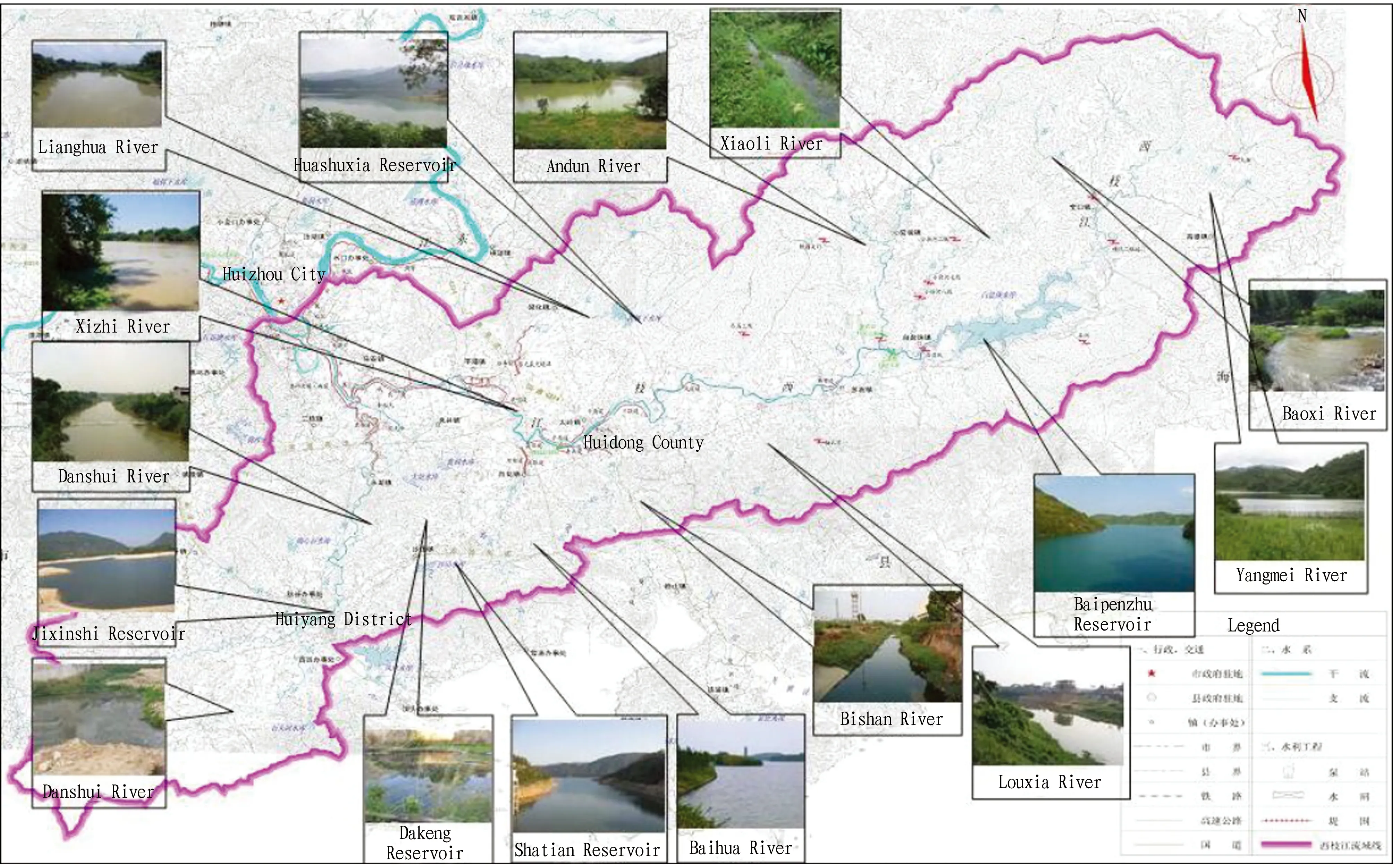
Fig.1 Map of Xizhi River Basin
3.2 Economic status of the basin area
3.2.1
Huidong County. According to preliminary calculation, the gross regional product (GDP) of Huidong County reached 52.03 billion yuan in 2015, an increase of 14.5% over the previous year. Specifically, the added value of the primary industry was 4.31 billion yuan, an increase of 7.0%; the added value of the secondary industry was 24.65 billion yuan, an increase of 19.2%; the added value of the tertiary industry was 23.08 billion yuan, an increase of 9.5%. The per capita GDP reached 55 959 yuan, an increase of 14.1%; the structure of the three industries was adjusted from 9.2∶45.4∶45.3 in the previous year to 8.3∶47.3∶44.4. The private economy added value of Huidong County was 32.97 billion yuan, an increase of 15.1%, and the private economy accounted for 63.4% of the county’s GDP.3.2.2
Huiyang District. In 2015, the region’s gross product (GDP) of Huiyang District was 33.012 billion yuan, an increase of 14% over the previous year. Specifically, the added value of the primary industry was 1.264 billion yuan, an increase of 4.1%; the added value of the secondary industry was 17.183 billion yuan, an increase of 19.9%; the added value of the tertiary industry was 14.565 billion yuan, an increase of 7%. The structure of the three industries was adjusted from 4.1∶51.3∶44.6 of the previous year to 3.8∶52.1∶44.1. According to the calculations based on the permanent population, the per capita GDP was 56 043 yuan, an increase of 13.5%. The annual financial revenue of Huiyang District was 4.621 billion yuan, of which the public budget revenue was 3.492 billion yuan, an increase of 16.9% and 25.1% respectively over the previous year. The total tax revenue was 5.119 billion yuan, an increase of 12.8%. Among them, national tax revenue was 2.527 billion yuan, an increase of 24.3%; land tax revenue was 2.592 billion yuan, an increase of 3.4%.3.2.3
Huicheng District. According to preliminary calculations, in 2015, the entire district (territories, including areas directly under the jurisdiction of Huizhou City) realized a gross regional product (GDP) of 56.013 billion yuan, an increase of 10.5% over the previous year. Specifically, the added value of the primary industry was 1.82 billion yuan, an increase of 4.6% over the previous year, and its contribution to GDP was 1.3%, driving GDP growth by 0.14 percentage points; the added value of the secondary industry was 18.217 billion yuan, an increase of 11.2% over the previous year, and its contribution to GDP was 37.5%, driving GDP growth by 3.95 percentage points; the added value of the tertiary industry was 35.976 billion yuan, an increase of 10.5% over the previous year, and its contribution to GDP was 61.2%, driving GDP growth by 6.45 percentage points. The proportion of the three industries is 3.3∶32.5∶64.2.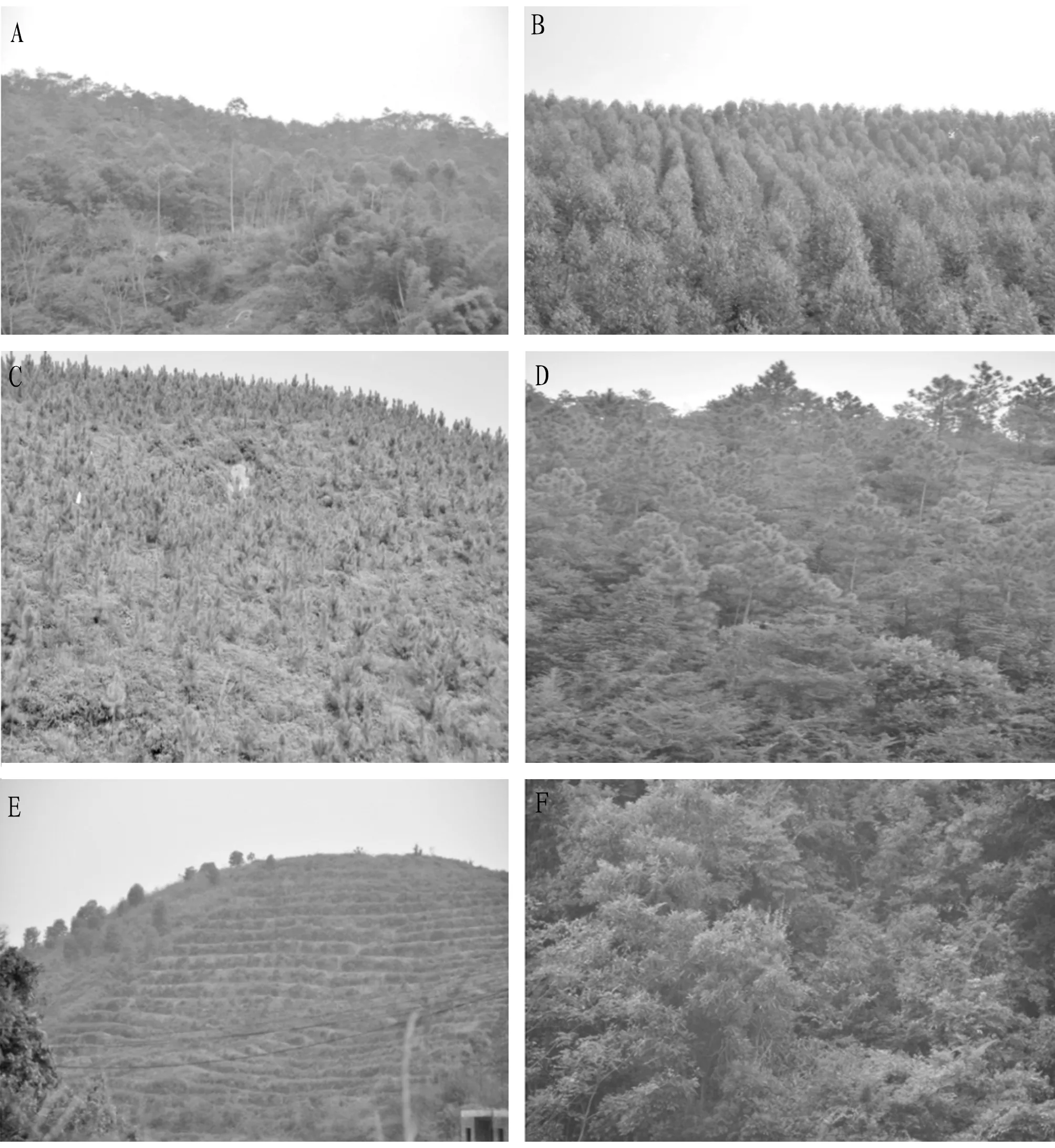
Note: A. Eucalyptus community in Andun Town, B. Eucalyptus forest (unmature forest) in Andun Town, C. Pinus elliottii community in Shierkong Nature Reserve, D. Pinus elliottii community (mature forest), E. Grapefruit orchard, F. Secondary forest (Engelhardia roxburghiana+Lithocarpus glaber+Gordonia axillaris+Dicranopteris dichotoma community).
3.3 Water quality and water resources development and utilization
3.3.1
Current status of river water quality (Table 1). Xizhi River is the second largest tributary of the East River which is one of the three largest water systems of Pearl River. It originates at the junction of Huidong County, Huizhou City and Zijin County, Heyuan City, flows through Huidong County, Huiyang District, and Huicheng District and then merges into Dong River (or East River). Its total length is about 176 km, the drainage area is 4 120 km, and its annual average rainfall is 1 900 mm. Baipenzhu Reservoir is built in the upper reaches. There are many tributaries in the Xizhi River Basin, 9 tributaries have the basin area larger than 100 km, most of the tributaries and nearly 70% of the basin area are located in Huidong County. The water quality of the Xizhi River Basin (monitoring results in 2005): the water quality of the upstream Baipenzhu Reservoir and Pingshan River section was good, reaching Class I-II water quality, and the monitoring indicators were stable throughout the year; the water quality at the dams reached Class II-III; the water quality in downstream sections of Zixi and Dongxin Bridge was poor, and due to the pollution of the Danshui River, the water quality exceeded Class III.3.3.2
Water quality of reservoir. According to the monitored data (Table 2), the eutrophication status of 6 of the 8 reservoirs was mildly mesotrophic, and the water quality was good and met various water requirements; the eutrophication status of 2 reservoirs was mild eutrophication, mainly caused by fish and duck farming in the reservoir area, and the water quality was suitable for agricultural water requirements.According to the recent water quality assessment, the water quality of the middle reaches of Xizhi River (above the Pingshan River section) could still be maintained at Class II-III, the water quality was good with stable indicators, stable change trends, and the pollution was not significant. However, in the lower reaches (Zixikou), due to the confluence of Danshui River, which accounted for nearly 1/3 of its flow, the water quality has dropped to Class V, and the function of the water body has been destroyed. The water quality of the three sections (Longgang, Pingshan, and Tuhu) on the Danshui River was Class V, with serious organic pollution. The pollutants discharged into the Danshui River have greatly exceeded the environmental capacity of the basin itself, and the river has lost its original functions, reaching the type of extreme deterioration. Danshui River is an important factor that directly affects the water quality of the lower reaches of the Xizhi River, and it also affects the water quality of the East River. The cities on both banks of the Danshui River and the lower reaches of the Xizhi River have experienced severe quality-induced water shortage. From the water quality changes along the Xizhi River, it can be known that the ammonia nitrogen and permanganate index along the river have a tendency to increase, indicating that the gradual deterioration of water quality of the river from upstream to downstream is mainly due to the direct discharge of sewage along the river. From the analysis of the short series trend, the water environment background quality of Pingshan Station in the surveyed section of the Xizhi River is relatively good; however, due to the increase in the development and utilization of the Xizhi River in recent years, the content of the permanganate index shows an upward trend.
3.4 Data preprocessing
3.4.1
Formula calculation. The quality-effect changes of the environment and ecology comply with the Weber-Fechner law, that is, when the environment and ecological quality indicators change in equal proportions, the environmental and ecological effects are changing equally. According to this law, dimensionless processing of indicators can be carried out as follows:a) Plus directional indicator:X
= Current value / Standard value.b) Minus directional indicator:X
= Standard value / Current value.Composite index calculation:
After dimensionless processing of indicators according to the Weber-Fechner law, the model adopted the weighted geometric arithmetic value method as the basic algorithm. Calculation formula at the scheme level:

(1)
whereB
is the calculation result of the first scheme level (DPSIR);X
is thej
index of thei
scheme level;W
is the weight of thej
indicator.For the calculation of target level, the Index of Ecological Security (IESI
):
(2)
whereW
is the weight of thei
-th scheme level.Based on the river ecological security assessment candidate indicators and the characteristics of the Xizhi River Basin, combined with the availability and significance of local data and other principles, we screened out indicators. For the driving forces, we selected three commonly used evaluation indicators: GDP per capita, population density of the river basin, and population growth rate of the river basin. For the pressure factors, we selected three indicators: CODemissions per 10 000 yuan of industrial output value, NH-N emissions per 10 000 yuan of industrial output value, and water resources development and utilization rate. For the state factors, we selected three indicators of river body ρ(COD), ρ(NH-N), and the degree of artificialization of the river section. For the impact factor, considering the rich vegetation in the Xizhi River Basin, we also selected two indicators, the forest coverage rate and the percentage of river pollution. For the response, we selected the rate of soil erosion control and the rate of urban sewage treatment that are stressed in ecological construction. Finally, we screened out 13 representative indicators, as shown in Table 3. After determining the evaluation indicator system, it is necessary to clarify the evaluation criteria of each indicator in order to assess the ecological security status of the river basin. At present, there is still no uniform ecological security standard for river basins in academic circle. According to the connotation of river basin ecological security and the requirements of river basin management, as well as the research on ecological security indicators at home and abroad, we established a set of scales and standards to assess the ecological security of rivers (Table 3).

Table 1 Water quality of centralized drinking water sources in Huizhou
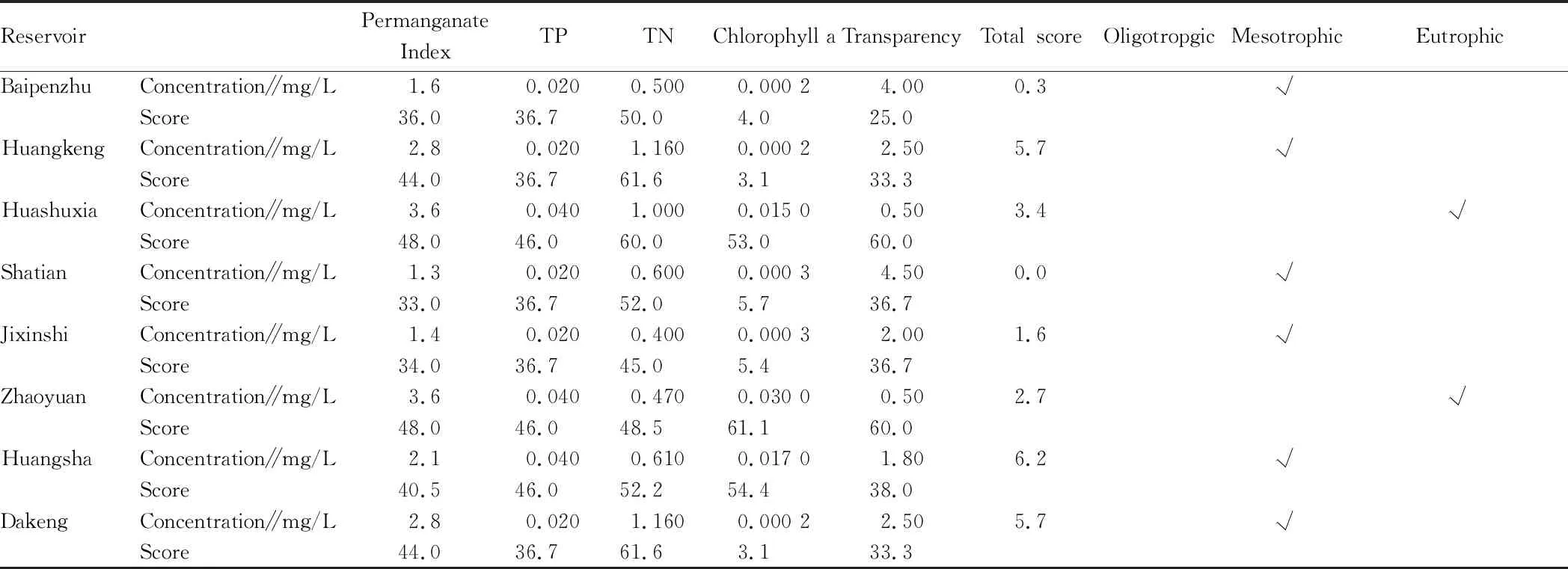
Table 2 Water quality status of reservoirs in the Xizhi River Basin
3.4.2
Scales and standards of river ecological security.3.4.3
Weight of indicators. The determination of safety level is the basis of ecological security assessment. Using the determined data preprocessing method, taking the ideal value in Table 3 as the standard value, and then substituting 4 different level values and the weights of each level in Table 4 into equations (1) and (2), the safety division of IESI is calculated. If the score of IESI is 0-0.26, it is very unsafe; if the score is 0.26-0.48, it is unsafe; if the score is 0.48-0.68, it is safe; if the score is 0.68-1.00, it is ideal.3.4.4
Calculation results. According to the indicator direction, using the current value and standard value, we first conducted dimensionless processing. Then, combined with their respective weights, we obtained the composite index of each scheme level, and finally by combining the weight of each scheme level, we obtained the composite ecological security index (Table 5).
Table 3 Scales and standards of river ecological security
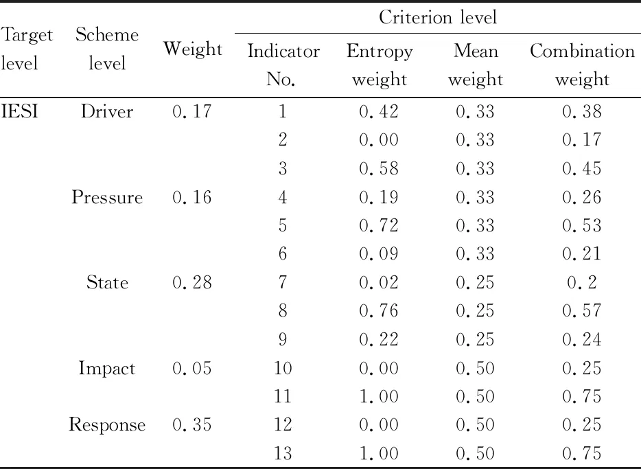
Table 4 Weight of indicators
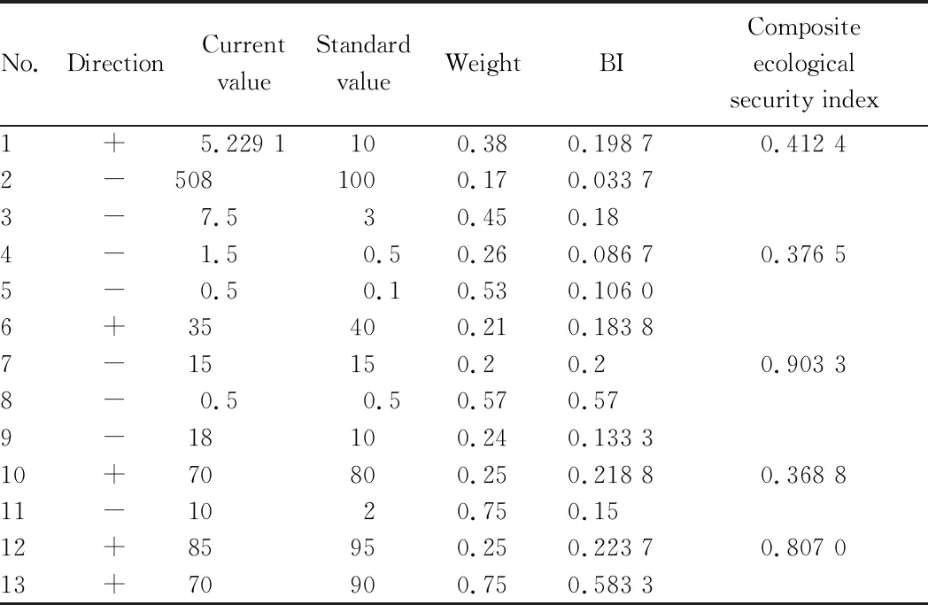
Table 5 Calculation results
4 Assessment results and analysis
4.1 Analysis of results at the scheme level
Through calculation, we obtained the composite index of the drivers-pressures-states-impacts-responses at the scheme level. The driver was in an unsafe area, close to safety. Pressure and impact were in an unsafe area. The status and response were close to 1 and in the ideal area.4.2 Analysis of results at the target level
Using Equation (2), we calculated the composite ecological security index in the Xizhi River Basin, the result was 0.684 162. Thus, it is currently in a safe state. Although the current water quality in the Xizhi River Basin is in a safe state, there are still many hidden dangers. Some water tends to be polluted, and some is threatened by the large-scale planting of eucalyptus which has great harm to the water retention characteristics and water conservation capacity of the soil in the basin. In order to strengthen the environmental construction and protection of the river basin, we came up with the following recommendations.(i) Vigorously building water source forests, implementing closure of mountains for afforestation, and promoting the development of water source forests to the development of climax community, so as to maximize the ecological benefits. In red soil mountains with poor vegetation coverage, it is recommended to set up equal height ditch ridges to turn long slopes into short slopes, so as to improve the drainage system of the mountains. For example, it is feasible to plant the excellent green manure forage varieties that are acid-tolerant, barren-tolerant, drought-tolerant, fast-growing, strong-resistant, strong tiller, strong regeneration, high biological yield, and developed root system along the hill slope, to make them play a good role in slope protection and soil consolidation, reduce runoff, protect water and soil, and conserve water.
(ii) The ecological function areas of the urban and rural areas along the river can be connected together to form an ecological function network, so that they can regulate climate, protect water and soil, purify water bodies, purify air and reduce noise, and create excellent environmental conditions for the overall development of the Xizhi River Basin.
(iii) Building water conservancy, improving the construction of hydropower, irrigation and drainage, and flood discharge projects for supporting the reservoirs, and giving full play to the functions of the Xizhi River in water storage, hydropower, flood discharge, irrigation, water intake, shipping, aquaculture, as well as tourism.
(iv) Making the overall planning of urban and rural construction along the river. In view of the current serious lag in infrastructure construction in villages and towns, and the excessively scattered distribution of infrastructure, government departments should make overall planning for towns and functional areas to guide industrial and agricultural production to orient towards industrialization and standardization, and guide population centralization towards towns and cities under control, to realize synchronous and coordinated development of social economy and environment in the river basin.
杂志排行
Asian Agricultural Research的其它文章
- Molecular Cloning and Bioinformatics Analysis of araC Gene of Vibrio alginolyticus
- Occurrence Regularity and Integrated Control Technology of Canker in Citrus
- Activation Effect of Hydrochemical Energy in Regenerative Agriculture on Nutrients of Arsenic Sandstone
- IS-LM Model Based Analysis on the Role of China’s Financial Policy for Supporting Agriculture
- Prediction and Protection of Cultivated Land in China
- Emergy Estimation of the Main Forest Biomass in Shangri-La, Tibetan Area of Yunnan Province
