Germanium/silica ratio and trace element composition of Early Cambrian siliceous rocks in Keping:implications for the siliceous rocks’ formation and paleoenvironment interpretations
2021-01-09ZixuanGuanShibiaoDengPeixianLiuYiqiuJinXingchunCao
Zixuan Guan · Shibiao Deng · Peixian Liu · Yiqiu Jin · Xingchun Cao
Abstract This study used the germanium/silica (Ge/Si)ratios, together with rare earth elements and other trace elements to infer the siliceous source and sedimentary environment of the siliceous rocks located at the bottom of Yuertusi Formation in Northwestern Tarim Basin, Keping,China.Previous studies have shown that this siliceous rock stratum formed at the edge of the carbonate platform on the continental shelf. Researchers suggest that these siliceous rocks were formed by hydrothermal activity,but some still draw different conclusions. Understanding the silicon source and depositional environment of these siliceous rocks would help us learn the processes of environmental changes and the causes of biological explosions during this period. The value of germanium/silica ratios of these siliceous rocks is from 0.15 to 0.37 μmol/mol and much lower than above 10 μmol/mol values in siliceous rocks that are known formed by hydrothermal activity. All samples are rich in HREE,which differ from hydrothermal siliceous rocks that are rich in LREE. Most samples lack hydrothermal related elements.All these features show that the source of these siliceous rocks’ siliceous is not hydrothermal fluids.The samples’Ce/Ce*range from 0.88 to 1, and Th/U ratios range from 0.01 to 0.36. These features suggest these siliceous rocks were formed in an anoxic environment. Considering all the evidence, we conclude that the siliceous rock stratum at the bottom of the Lower Cambrian Yuertusi Formation in northwest Tarim Basin,Keping,was formed in anoxic seawater at the edge of the carbonate platform on the continental shelf.Its silicon source is seawater instead of hydrothermal fluid.
Keywords Siliceous rocks·Trace elements ·Ge/Si ratio ·Tarim Basin
1 Introduction
The Ediacaran–Cambrian transition is a primary node in the evolution of the global paleoenvironment,during which major geology events such as ‘‘Snowball Earth,’’ ‘‘Supercontinental Cracking,’’ and ‘‘Cambrian Explosion’’ had occurred.This process is fully recorded in the Yangtze and Tarim platforms in China (Zhang et al. 2016). The Lower Cambrian black rock series (the Black Shales) in the Yangtze platform has important features such as a polymetallic enrichment layer(Ni–Mo–V–Au)and the Oceanic Anoxic Event(OAE),and have received in-depth studies in geosciences(Li et al.2015).However,the Early Cambrian Ocean’s environmental data in the Tarim Basin is quite scarce compared with the black shale.Research in this area is also lacking.
The Yuertusi Formation in the northwest Tarim basin is formed in the Early Cambrian era. The stratigraphic horizon is equivalent to the Blake Shales in the Yangtze platform. Similar to the Blake Shales, several layers of siliceous rock appear at the bottom of Yuertusi Formation.The siliceous rock is a kind of sediment rock formed in chemical or biochemical processes. Meaningful and abundant geochemical information in siliceous rock can be well persevered for long periods of time because of the dense structure and stable chemical properties of siliceous rock (Chunlong 2001). Two main sources of siliceous materials can form siliceous rocks.One is from weathering on the continent, and the other is from deep earth (Hesse 1989). About 80% of soluble SiO2in seawater is from the continent, and the other 20% is from deep-Earth (Treguer et al.1995;Froelich et al.1989).These two kinds of rocks from different siliceous sources have different trace element compositions. Thus, they can be distinguished by analyzing their trace elemental composition.
Many researchers have focused on the sources and the sedimentary environment of this siliceous rock recent years. Several different opinions about the sources of this siliceous rock have been stated. Sun et al. (2008) studied trace elements and rare earth elements of the siliceous rocks in this area, and suggest that siliceous rock is likely deposited from hydrothermal fluid and formed in continental margin-abyssal environment.Bingsong et al.(2004)analyzed trace elements of the siliceous rocks samples taken from Sholbrak section located at east Keping and concluded that the upwelling current carries the substances formed in the pelagic ocean floor onto the shelf to deposit those siliceous rocks. Sun et al. (2008) studied noble gas isotopes from inclusions of the siliceous rock taken from Sholbrak (east of Keping) and Shuiquan (south of Kuruktag). They suggest that the siliceous rocks formed on the continent shelf and its siliceous was from submarine volcano activity and transported to the continental shelf by hydrothermal plumes. Chen et al. (2010) analyzed δ30Si and δ18O of bedded siliceous rocks at the bottom of Cambrian strata and cherts-bearing dolostone on the top of Cambrian strata. They believe that the bedded siliceous rocks are sedimentary sources. Yin et al. (2015) think the siliceous rocks formed in the deep-basin and related to hydrothermal activity by analyzing their main elements and trace elements.
In general, most researchers believe that the siliceous rocks at the bottom of the Yuertusi Formation in the northwestern margin of the Tarim Basin have a certain level of relationship with hydrothermal fluids, and their tectonic location is close to the oceanic basin. However,there are also views that these siliceous rocks are mainly from seawater deposition. Exploring the siliceous source and depositional environment of these siliceous rocks will help us understand the processes of environmental changes and causes of biological explosions during this period.
Previous studies mainly used rare earth elements and trace elements to find the siliceous rock’s material source.However, due to the diverse nature of these elements and multiple sources, it is impossible to define the source of siliceous rock firmly.This research uses a decisive method:germanium/silica (Ge/Si) ratio, combined with rare earth elements and trace elements geochemical characteristics,to study the sedimentary environments and the siliceous source of siliceous rocks in this region.
2 Geological settings
The Tarim Basin is located in the northwest of China.Being the largest basin in China, it is about 0.56 million kilo squares. The basin was almost covered by desert. The west rim of the basin is Palmier highland, the north rim is Tianshan Mountains,and the south rim is the west Kunlun Mountains and Arkin Mountains (Zhiqin et al. 2011).
This area of interest is in the northwest margin of Tarim Basin, Wushi County, Arksu (Fig. 1). In this area, the continued strata from Ediacaran to Ordovician is distributed in several nappe belts.The rocks in these strata are mainly carbonate, including limestone and dolomite. The siliceous rocks are at the bottom of the Yuertus Formation,the earliest stratum of the Cambrian.
The Yuertus Formation can be divided into two parts.The upper part of this formation mainly consists of sandy dolomite with a little chert, and the lower part mainly banded siliceous rocks and black shales.The stratum under the Yuertus Formation is Qigebuluk Formation, and there is a parallel unconformity between these two strata. The overlay stratum is Xiaoerbuluk Formation, which is also separated by a parallel unconformity with Yuertus Formation. The sedimentary environment of Yuertus Formation was a margin of carbonate reef located upon the continental shelf. The sedimentary environment was deepwater, and the water depth became shallow gradually over time. But its sedimentary environment was a continental shelf environment overall (Deng 2017).
3 Background: Ge/Si ratio
Germanium is one of the Carbon group elements and has similar chemical properties with silicon. Only a few kinds of minerals are rich in Ge,most of Ge in the crust is in the dispersive state.Because of these properties,Ge is like the‘‘isotope’’ of Si in rocks. Similar to other stable isotope systems, the abundance of Germanium in geological samples is always expressed in the Ge/Si ratio, which is the ratio of the amount of substance of these two elements in samples. Because of the sizeable abundant difference between Ge and Si,the unit of the Ge/Si ratio is μmol/mol.
According to the study made by Froelich et al., Germanium is more likely to come into clay minerals instead of transported in a dissolved state, so the Ge/Si ratio in river water is low (Froelich et al. 1992). This effect is related to weathering strength. The more substantial weathering leads to a lower Ge/Si ratio in river water. The average value of the Ge/Si ratio of global rivers water is about 0.54 μmol/mol (Froelich et al. 1992; Mortlock and Frohlich 1987). The Ge/Si ratio of hydrothermal fluid is much higher than groundwater, so the siliceous rocks formed by hydrothermal activity also have a high Ge/Si ratio ranging from 8 to 13 μmol/mol (Mortlock et al.1993).The Ge/Si ratio of seawater is affected by both river water from continents and hydrothermal fluid from midocean ridges. Modern seawater’s Ge/Si ratio is about 0.72 μmol/mol and much lower than hydrothermal fluid.So, Ge/Si ratio is a useful tool to identify the primary sources of siliceous rocks.
The method mentioned above has been used to find out the siliceous source of silica part in BIF. Researchers measured the samples taken from BIFs in Precambrian Hamersley formation in west Australia. It shows that the bands rich in iron have a higher Ge/Si ratio than the pour silica bands and have ten times the difference. The result suggested that the iron and silica in BIFs may have different sources (Hamade et al. 2003). Dong et al. had researched the cherts in Laopu formation at the Silikou section, Guangxi province. They find the siliceous component in the samples had low Ge/Si ratios range from 0.4 to 0.6 μmol/mol, and suggest that the siliceous source of the chert should be seawater instead of hydrothermal fluid(Dong et al. 2015, Cui et al. 2019).
4 Sampling and analytical procedures
4.1 The sections and the samples
This study took 17 samples from 3 sections in the study area.Most of the samples were taken from the Jinlinkuang section which had the thickest siliceous rock layer in three sections, and these samples’ name starts with ‘‘JLK’’. The other two sections were the Sugate-Bulak section and Kulunan section. The location of these three sections was marked in Fig. 1. The followings are the detail of these three sections and the samples taken from them.
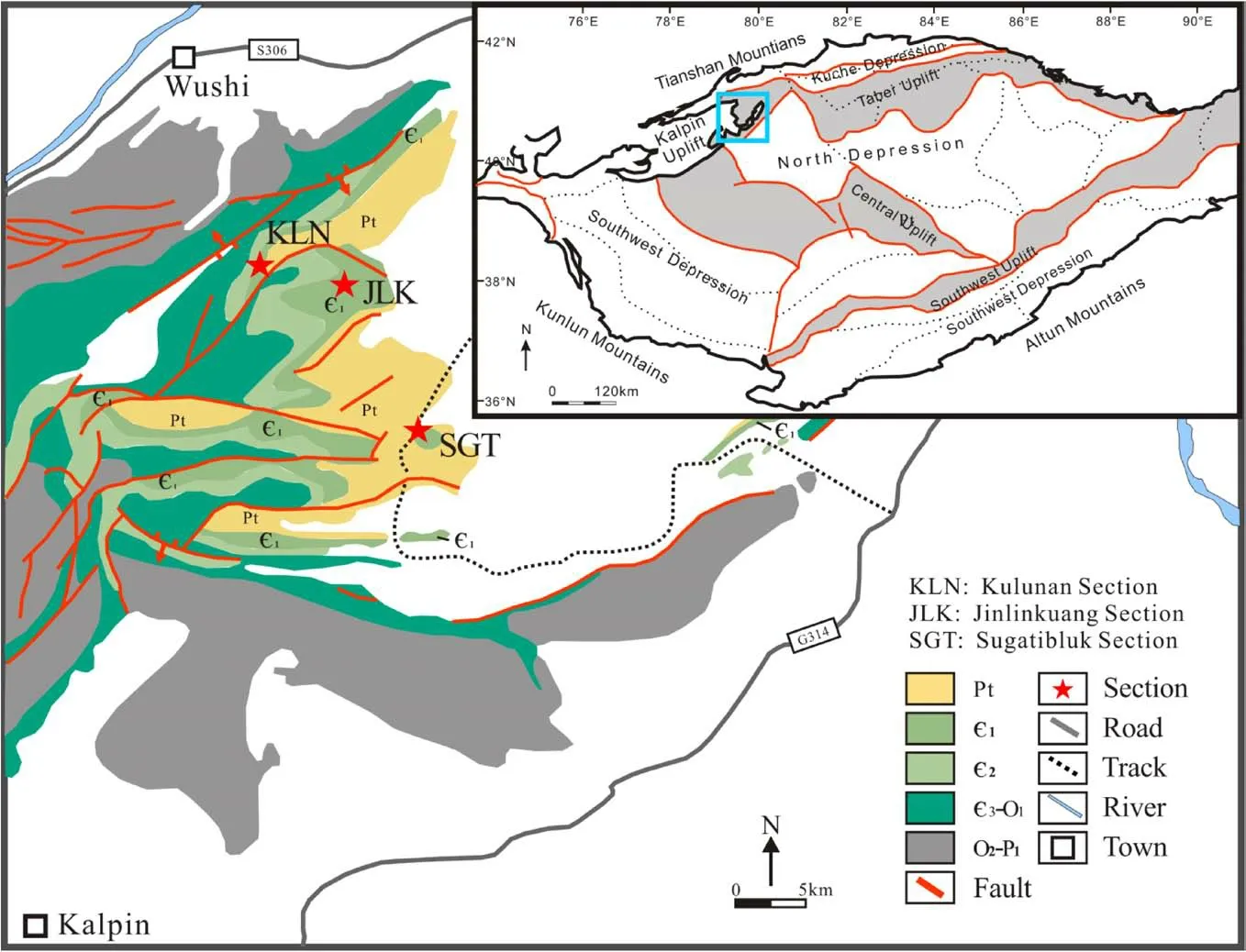
Fig. 1 Brief structure setting of Tarim Basin and location of the research zone. (Modified from Jia 1997; Deng 2017)

Fig. 2 Field photographs of siliceous rocks in the Yuertus formation from three sections.a Jinlinkuang section (JLK),b Kulunan section (KLN),c Sugate-Bulak section (SGT)
Jinlinkuang section (JLK) lay in the center of the research zone.Its coordinate is 41°2′40.44′′N,79°25′7.16′′E.The thickness of the Yuertus Formation in this section is 15 m and can be divided into six layers (Fig. 2).
From bottom to top, the first layer is a thin layer siliceous rock, and the thickness is 0.3 m. The second is the thin layer siliceous rock interlayer with thin layer phosphorus mudstone,and the is 2.5 m thick.The third is a thin layer of siliceous rock, and its thickness is 1.5 m. The fourth layer is about 1 m thick and is a siliceous rock interlayer with dolo-mudstone. The fifth layer is sand dolomite with some siliceous bands, and these bands are cluttered. This layer is about 3 m thick. The top layer of this formation in this section is sand-dolomite and has no siliceous rock in it.
The Kunlunan section(KLN)lay in the northwest of the research zone and near the Jinlinkuang section. Its coordinate is 41°3′41.79′′N, 79°17′53.95′′E. The total thickness of the Yuertus Formation in this section is 19 m and can be divided into four layers. The siliceous rocks can be seen at the lower two layers in this section.The first layer is a thin layer of siliceous rock, and its thickness is 4 m. The second layer is a siliceous rock interlayer with dolomite,and it is 4.5 m thick. The third and the fourth layer is mainly consisting of sand-dolomite, almost no siliceous in it.
Sugate-Bulak section (SGT) lay in the south of the research zone. Its coordinate is 40°54′22.84′′N,79°28′45.70′′E. The total thickness of the Yuertus Formation in this section is 22 m and can be divided into four layers. The siliceous rocks only appeared at the lower two layers in this section.The first layer is a thin layer siliceous rock interlayer with thin black shale with about 1 m thick.The second layer is light yellow dolomite with some chert nodules in it and is 2 m thick.
The siliceous rocks can be divided into two types of layered siliceous rock and banded siliceous rock with chert nodule in dolomite.The two types of siliceous rocks can be found in all of those sections mentioned above. The rock columns and sampling locations of these sections can be seen in Fig. 3.
4.2 Microscopy
The slice observation found that all samples’siliceous parts are made by chalcedony.The layered type and non-layered type have no significant difference in micromorphology.The chalcedony in siliceous rocks is granular, and the size of grains ranges from 5 to 10 μm, some chalcedony grains have a flower-like shape and twisted contact with others.The chalcedony is colorless and clear in the monoscopic observation. Its interference color is grey or light blue under the orthoscope. Some grains are yellow or brown color because of the impurities (Fig. 4a). There are many lumps in most of these samples. Most of the lumps are brown or black and opaque.The shape of most lumps is an irregular bar. Their long axis length ranges from 100 to 500 μm, and the short-axis ranges from 50 to 200 μm(Fig. 4b). There are many small ferric particles distributed in chalcedony.The size of the ferric particles ranges from 1 to 5 μm(Fig. 4c).No large barite crystal has been found in all slices, the barite may be small particles or hide in opaque lumps. Some fossils are recognized in several slices, most of them are Cyanobacteria, sponge, or Algae.Well-preserved fossils: Megathrix longus, has been found in JLK-02 (Fig. 4d).
4.3 Analysis steps
4.3.1 Pretreatment
Siliceous parts were hand-picked from samples and were crushed to 200 meshes by using an electromagnetic grinder.The powder sample was repeatedly washed in 1 N HCl for three times to remove calcareous content. The calcareous-free insoluble residue was then subjected to 3 additional washes by deionized water and dried down in a Drying Cabinet at 65 °C.

Fig. 3 The strata columns of three sections and the sampling location
About 100 mg carbonate-free sample was dissolved in a Teflon beaker by a mixture of 3 mL concentrated HF and 1 mL concentrated HNO3at 120 °C for 48 h.The solution was dried down in a hotplate, and the residue was then dissolved in 3 mL concentrated HNO3at 120 °C for 24 h.After dried down in a hotplate, the residue was then dissolved in 2% HNO3for elemental composition analyses.This dissolution procedure would cause silica loss due to the formation of volatile SiF4,while Ge would be retained in solution because of the high boiling point of GeF4at 300 °C.
4.3.2 ICP-OES and ICP-MS
The major elemental compositions were determined by an inductively-coupled-plasma optical emission spectrometer(ICP-OES) at Peking University. At the same time, the trace element contents were measured by an ICP mass spectrometry (ICP-MS) at the Chinese Academy of Geological Sciences. The elemental compositions were calculated on the carbonate-free basis, and all major and minor elements are considered as oxides(i.e.,Na2O,MgO,Al2O3,SiO2, K2O, CaO, FeO, MnO, P2O5, TiO2). The silica content was determined by the bulk sample weight(carbonate-free) minus the total weight of all other oxides.The analytical precisions are better than 10%for both ICPOES and ICP-MS analyses.
4.3.3 Interference from BaO polyatomic ions
The Ba element in the sample will interfere with the Eu measurement when using ICP-MS to measure rock samples.Some polyatomic ions of Ba may have similar masses to Eu(Bi et al.2016;Guan et al.2013).Similar phenomena have also been observed in our data. There are linear correlations between the measured values of Ba and Eu and the measured values of Ba and Sm (Fig. 5). There are methods for correcting measurement data using standard samples or mathematical methods. However, in our research, the Ba content of the sample is too high, and the laboratory’s conventional correction methods are not very effective.
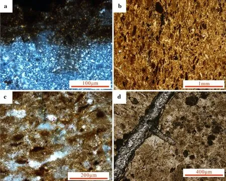
Fig. 4 Photomicrographs showing the texture of siliceous rocks of Yurtus formation.a JLK-07. Chalcedony under crossed polars. Some of the impurities show yellow or brown; b JLK-03. Lumps with black color; c JLK-07. Small ferric particles distributed in chalcedony; d JLK-02. Fossils in rocks, especially Megathrix longus
5 Results and discussions
5.1 Ge/Si ratio
The elemental compositions and Ge/Si ratios are listed in Table 1.All samples have high SiO2and a low Ge/Si ratio.The samples’Ge/Si ratios range from 0.15 to 0.37(n = 17,average = 0.249), the average values of layered and nonlayered siliceous rocks are 0.227 (n = 9) and 0.277 (n = 8). There is no significant difference between the two types, and they are both much lower than the siliceous rock form by hydrothermal activity. That is, the result of the Ge/Si ratio shows that the siliceous source of siliceous rocks at the bottom of Yuertus formation is seawater.
5.2 Major element contents
17 siliceous rock samples’ major element compositions were analyzed and listed in Table 1.All samples have high Si content, while other major element contents are lower than 5%. All samples have extremely low Mn content(1–10 ppm).
Al and Ti come from continent weathering,while Fe and Mn are from hydrothermal fluids (Murray et al.1990, 1991; Murray 1994). Bostrom though the elements Al,Fe,and Mn can be used to distinguished the sources of sediment and sedimentary rock,and made a Fe–Al–Mn trigraphic and Al/(Al + Fe + Mn) index (Bostro¨m and Peterson 1969).Adachi then used this index and graphic in siliceous rocks study (Adachi et al. 1986).
In this study,the content of Al is higher than Fe in most samples except JLK-01. Most samples have high Al/(Al + Fe + Mn) range from 0.80 to 0.95 (n = 16, average = 0.907), but JLK-01 is 0.224. The average value of layered siliceous rock samples and non-layered siliceous rock samples is 0.823 (n = 9, include JLK-01) and 0.916(n = 8).Both two types of siliceous rock are rich in Al.The major elements suggested that most of the siliceous rocks came from seawater instead of hydrothermal fluid.
5.3 REE feature of siliceous rocks
We analyzed the rare earth element composition of 17 samples, which are listed in Table 2. The data in this table for Sm, Eu, and Gd are corrected values. The total REE of these samples is 1.33 to 4.72 ppm,the total REE of layered siliceous rocks is 1.92 to 4.72 ppm (average = 3.53 ppm, n = 9), and the total REE of non-layered siliceous rocks is 1.33 To 4.07 ppm (average value =2.31 ppm, n = 8).
5.3.1 REE patterns

Fig. 5 a The chart of correlation between Ba and Eu,Sm,Gd.Eu and Sm are greatly affected by Ba content, while Gd is not significantly affected. b The chart of the correlation between Eu and Sm. Eu and Sm have a linear correlation
The REE data was normalized against PAAS (McLennan 1989) and plotted in Fig. 6. All samples have similar REE patterns. They are rich in HREE. The La/Yb values of all samples are range from 0.59 to 2.53, the layered siliceous rocks’ La/Yb values are from 0.61 to 2.53 (mean = 1.04,n = 9), the non-layered siliceous rocks’ La/Yb values are from 0.59 to 1.72 (mean = 0.92, n = 8).
These features are similar to dolomites’ REE features from Ordovician Sholbrak formation in the same area(Zhang et al. 2014). These dolomites are formed by early burial dolomitization instead of hydrothermal fluid. These samples are all enriched with HREE, which is one of the important features of seawater. It is also an obvious difference in hydrothermal fluid(Douville et al.1999;Zhenju et al. 2000). This is one of the pieces of evidence that the siliceous source of these siliceous rocks is seawater.
5.3.2 Ce anomaly
Ce is an element sensitive to the changing of the redox environment. The seawater in the oxidizing conditions always shows obviously low Ce/Ce*value,while a Ce/Ce*value nearly 1 or higher than 1 means reducing habitat(German et al. 1991). Ce anomaly values were calculated by Ce/Ce*=the subscript N means the normalized values of elements. The Ce/Ce* of samples were shown in Table 2. Samples’ Ce/Ce* values range from 0.51 to 0.90, and the average is 0.628. The layered siliceous rock samples’Ce/Ce*values are range from 0.52 to 0.63 (mean = 0.572, n = 9) and the non-layered siliceous rock samples’ values are range from 0.51 to 0.90(mean = 0.684, n = 8). No significant difference between the two kinds of siliceous rock on Ce/Ce* value.Besides, according to Murray’s studies, the siliceous rocks formed in mid-ocean ridge, deep-sea basin, and continent margin have significant differences in Ce/Ce* value. The typical value of these three kinds is 0.29, 0.55, and 1.30(Murray et al.1990,1991;Murray 1994).The samples’Ce/Ce* values in this study are in the middle of the last two types. The slightly negative Ce anomalies suggest two kinds of siliceous rock were both formed in an anoxic environment.
5.4 Other trace elements features
5.4.1 U and Th/U ratio
At the surface environment, the element Th shows in valence + 4 and always forms insoluble compounds. The U shows valence + 4 in an anoxic environment and forms insoluble compounds. However, in the oxidizing conditions, the U shows valence + 6 and forms soluble compounds in water.Therefore,the U element can transport by water in an oxidizing condition but will settle down in an anoxic environment. The average content of the Th element is a little higher than the U element in the crust.According to this law, if the Th/U ratio is lower than 1.0 and U element content is higher than Th element in sedimentary rock,this rock may form in an anoxic environment(Huajin et al. 2009). This method had been used in much sedimentary research for finding out the redox status of sedimentary environments(Sun et al.2008;Bingsong et al.2004; Yin et al. 2015; Liu and Zheng 1993).
The data of U,Th element,and Th/U ratio was listed in Table 3. JLK-07 has an extremely high U content. This sample may be contaminated and not counted.All samples in this study had high U values.The Th/U values of layered siliceous rock samples range from 0.02 to 0.13 (mean =0.07,n = 9),the Th/U value of non-layered siliceous rock samples are range from 0.03 to 0.22(JLK-07 was not included,mean = 0.14,n = 7).This result shows that these siliceous rocks formed in an anoxic environment. This result is consistent with the Ce/Ce*’s result on the redox environment.
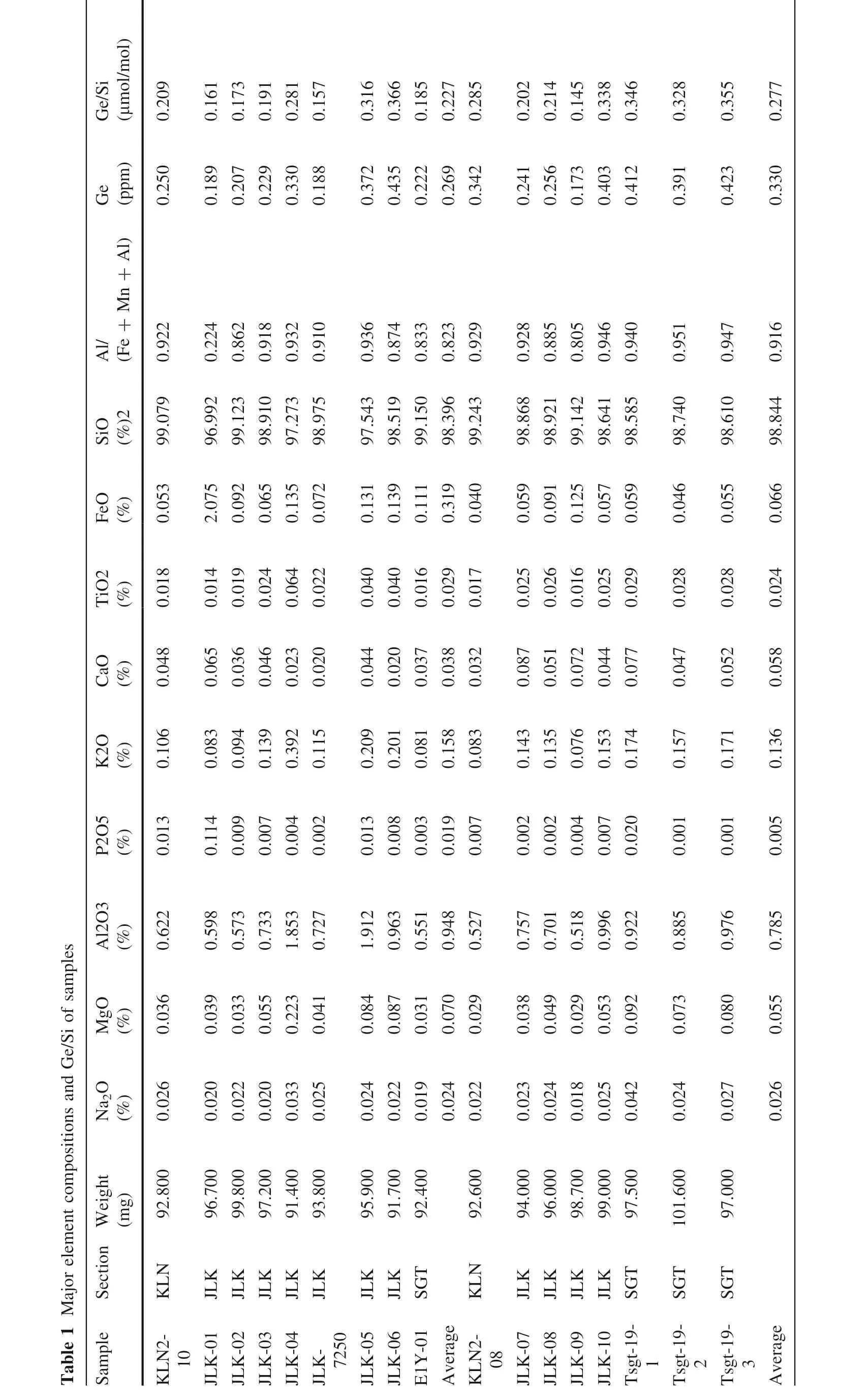

Table 2 Rare earth element data of siliceous rocks in Yuertusi Formation (unit: ppm)
5.4.2 Hydrothermal related elements
Some elements were always seen as having a strong relationship with hydrothermal activities, such as Ba, As, Sb,Hg, Pb, and Se (Liu and Zhang 1993; Zhou et al. 2000).However, some elements’ contents are related to hydrothermal activities, and the redox environment can also be one of the key factors.
Some samples in this study have high Ba contents, but that is not substantial evidence for hydrothermal activities.The layered barite rocks had been founded in many Late Proterozoic and Early Paleozoic strata. These barite rocks were not formed by hydrothermal activity but related to high surface productivity or significant continent weathering(Jewell 2000).According to the research about modern seawater,there are many micrometer-sized barite grains in seawater (Dehairs et al. 1980). These barite grains will deposit on the seafloor with other sediments. The high Ba contents in sedimentary rocks cannot conclude hydrothermal activities. In this study, no large barite crystal have been founded in samples during the slice observation. If barite is directly crystallized in hydrothermal activity,they would form bigger crystals with size 40–70 μm due to crystal habit than those formed in seawater and this kind of barite can be seen easily in rock slices.
Arsenic (As) is also one of the hydrothermal related elements. However, there is also an element sensitivity to the redox environment because it has a similar nature to sulfur (S). The samples of this study all have higher As values compare with the average value of upper-crust rocks, which is about 1.5 ppm (Taylor and Mclennan 1985). The Arsenic contents of layered siliceous rock samples range from 2.16 to 20.90 ppm(mean = 4.56 ppm,n = 9), and the non-layered siliceous rock samples’ As contents range from 0.96 to 4.32 ppm (mean = 2.23 ppm,n = 8). It seems that this result suggested the As in these siliceous rocks may not come from the continent.However,such low values compared to typical hydrothermal siliceous rocks’ As content, which is about 200 ppm (Liu and Zheng 1993), cannot be the evidence of hydrothermal activity.
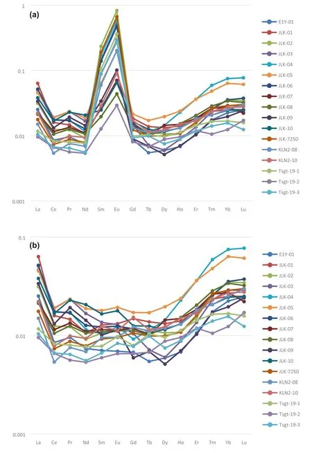
Fig. 6 a The uncorrected REE distribution pattern of siliceous rocks in Yuertusi Formation,data of PAAS come from McLennan (1989). Affected by the excessively high Ba content in the sample,the values of Sm,Eu, and Gd are significantly higher than normal. b The REE distribution pattern of siliceous rocks in Yuertusi Formation.Assuming that Sm is not abnormal, the measured values of Sm and Ba are used to correct Eu, and the values of Pr and Ce is used to correct Gd
5.4.3 Trend of elements content on one section

This study had continuously sampled the Jinlinkuang(JLK)section, and 11 samples were obtained. Although different kinds of elements have a significant difference in content,they do have some similarities in their content change along the section. Figure 7 shows the elements content changing along the section. The trend of elements content has these features:
1. There are two peaks along the section, one is at JLK-01,and the other is at JLK-04. The trace elements can be divided into two groups based on where the peak appears.
2. Cu, As, Mo, Cd, and other several elements peaks at JLK-01 (Fig. 7a). These elements have a common feature: they all belong to siderophile elements or chalcophile elements. These elements often enrich in reducing conditions. The major elements, Fe and P,also peak at the same position. These elements also have high value in deep basin sediment.
3. Li,Ti,V, Cr, and other several elements peak in JLK-04(Fig. 7b). Most of these elements are belong to lithophile elements and always considered to be the elements representing continental sources. The major elements, Al and K, also peaks in the same position.
4. These two groups do not have an intersection. Some elements which peak in JLK-04 even have the lowest value in JLK-01.
Based on these features, we believe a little shale may pollute the sample JLK-04. It can also be evidence of a significant terrestrial input event; JLK-01 may form in a strong reducing, even euxinic environment.
However, according to previous studies about the sedimentary environment and paleogeography in this region,there should be a continental shelf margin environment.One explanation is that upwelling water brought the deep basin water to the shelf,which is also the view of Yu et al.(2004).
6 Contrast with other studies
Different research about the siliceous rocks in this district had been done in the last 20 years.However,most of these researches were forces on the east part of this district near Arcsu instead of the area in which these three sections were located.
In this study, the average value of samples’ Fe and Mn content is lower than the study made by Yin et al. (2015).The Ce/Ce* values in this study are about 0.88–1 and higher than Yu’s result(Bingsong et al.2004).The average contents of trace elements such as As in this study are lower than Sun’s result(Sun et al.2008).The difference in analytical procedures and measurement methods may lead to the difference in data. However, these differences between this study and other studies suggest that these siliceous rocks from different areas have different chemical compositions. That is to say, the results and conclusions from studies in a small region may not fit for the whole region.
Bingsong et al. (2004) found that the lowest layer in siliceous rocks stratum was rich in hydrothermal related elements, which was the evidence of the existence of an upwelling ocean current. In this study, the sample JLK-01 taken from the bottom layer of this siliceous rock stratum also showed high contents on several elements such as P,Cu,and Ni.This result seems to be the same as Yu’s result.Cautiously, the abnormal data on one sample may come from many reasons that upwelling ocean current may not be the only explanation.
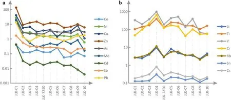
Fig. 7 Trend of elements content on JLK section, the unite of Y-axis is ppm (10-6). From left to right (JLK-01 to JLK-10), the order is from bottom to top
Some studies have reported that some hydrothermal structures including veins and saddle crystals were founded at the top part of Qigebuluk Formation, which is just laid under the siliceous rock stratum. The hydrothermal activity, which made these structures also formed these siliceous rocks.However,some studies did not support this opinion. Qian et al’s. (2014) study showed that these structures formed at the penecontemporaneous stage or later. Because of the hiatus between Qigebuluk Formation and Yuertus Formation, the formation time of these structures may be much earlier than siliceous rocks’formation.
7 Conclusions
At the bottom of Yuertusi Formation in Northwestern Tarim Basin, Keping, a siliceous rock stratum appeared.This stratum included layered siliceous rocks and banded siliceous rocks sandwiched in dolomite. After analyzed its major elements and trace elements composition, we draw the following conclusions.
First,all samples have low Ge/Si ratios,and these values are range from 0.15 to 0.37 μmol/mol. These values are much lower than the siliceous rocks formed by hydrothermal activity. The contents of hydrothermal related elements in these samples are much lower than typical hydrothermal formed siliceous rocks. The evidence shows that these siliceous rocks’main siliceous source is seawater instead of hydrothermal fluid.
Second, the samples’ Th/U ratios are all lower than 1.Furthermore,the Ce/Ce*of these samples ranges from 0.88 to 0.99, much higher than normal seawater. This evidence shows that these siliceous rocks were formed in a reducing environment.
Third,these siliceous rocks are rich in Al.The samples’average Al/(Al + Mn + Fe) is higher than 0.8. The average value of Ce/Ce* of these samples is about 0.95. This value is between the ocean basin type (0.55) and the continent margin (1.34). Considering the evidence from geochemical and sedimentology, the tectonic environment of siliceous rocks in Yuertus Formation is a continental shelf.
Fourth, JLK-01 is rich in Fe, P, As, Cu, and Mo and much higher than other samples. The upwelling ocean current may be the reason.
AcknowledgementsThis study is financially supported by National Key Basic Research Program of China (973 Program, No.2012CB214801).We also thank Prof.Dong Lin at Peking University for the help in the ICP-OES analyses.
杂志排行
Acta Geochimica的其它文章
- In situ LA-ICP-MS analyses of mica and wolframite from the Maoping tungsten deposit, southern Jiangxi, China
- Mineralogy and geochemistry of pozzolans from the Tombel Plain, Bamileke Plateau, and Noun Plain monogenetic volcanoes in the central part of the Cameroon Volcanic Line
- Zircon U-Pb geochronology, whole-rock geochemical,and Sr-Nd-Pb isotopic constraints on the timing and origin of Permian and Triassic mafic dykes from eastern North China Craton
- Geotectonic significance of the Neoproterozoic ophiolitic metagabbros of Muiswirab area, South Eastern Desert, Egypt:constraints from their mineralogical and geochemical characteristics
- Contribution of Asian dust to soils in Southeast China estimated with Nd and Pb isotopic compositions
- Geology, geochemistry, fluid inclusions and O-H stable isotope constraints on genesis of the Lake Siah Fe-oxide ± apatite deposit,NE Bafq, Central Iran
