Extensive Cold-Precipitation-Freezing Events in Southern China and Their Circulation Characteristics
2021-01-05JingBeiPENGCholawBUEHandZuoWeiXIE
Jing-Bei PENG, Cholaw BUEH, and Zuo-Wei XIE
Institute of Atmospheric Physics, Chinese Academy of Sciences, Beijing 100029, China
ABSTRACT Concurrence of low temperature, precipitation and freezing weather in an extensive area would cause devastating impacts on local economy and society. We call such a combination of concurrent disastrous weather “extensive coldprecipitation-freezing” events (ECPFEs). In this study, the ECPFEs in southern China (15°-35°N, 102°-123°E) are objectively defined by using daily surface observational data for the period 1951-2013. An ECPFE in southern China is defined if the low temperature area, precipitation area and freezing area concurrently exceed their respective thresholds for at least three consecutive days. The identified ECPFEs are shown to be reasonable and reliable, compared with those in previous studies. The circulation anomalies in ECPFEs are characterized by a large-scale tilted ridge and trough pairing over mid- and high-latitude Eurasia, and the intensified subtropical westerlies along the southern foot of the Tibetan Plateau and the anomalous anticyclonic circulation over the subtropical western Pacific. Comparative analysis reveals that the stable cold air from the north and the warm and moist air from the south converge, facilitating a favorable environment for the concurrence of extensive low-temperature, precipitation and freezing weather.
Key words: extensive cold-precipitation-freezing event, southern China, large-scale tilted ridge and trough, trough over the Bay of Bengal, western Pacific subtropical high
1. Introduction
Under specific conditions, low temperature, precipitation and freezing weather can concur in an extensive area.For example, in January 2008, southern China experienced severe low temperatures, precipitation and freezing weather,which brought severe adverse impacts on electricity infrastructure, transportation, and agriculture (Tao and Wei, 2008;Wang et al., 2008). It has been recognized that such a combination of these three types of disastrous weather events,which we hereafter refer to as “extensive cold-precipitationfreezing” events (ECPFE), is a devastating form of wintertime meteorological disaster in southern China. Between 1978 and 2008, there were 11 ECPFEs in southern China that lasted more than 10 days (Zong et al., 2013), and these recurrent ECPFEs can cause serious economic losses. In January 2011 and January 2018, for example, pronounced ECPFEs swept across southern China and caused economic losses of roughly 10 and 3 billion Chinese Yuan, respectively (Wei, 2011; Liu et al., 2018).
Traditionally, extensive and persistent low temperature events, extensive extreme precipitation events, and extensive and persistent freezing events in China have been defined separately (Peng and Bueh, 2011; Wang, 2014;Zong et al., 2014). In fact, however, the above-mentioned three types of events cannot be fully isolated from each other, and may concur to form a combined event, i.e., an ECPFE. With a subjective definition, the National Meteorological Center of the China Meteorological Administration(NMC/CMA) provided information on 62 ECPFEs in China from 1978 to 2008 (Zong et al., 2013). However, although ECPFEs have been investigated for individual cases, an objective definition for them is thus far lacking. Therefore,it is necessary to comprehensively consider these three elements of temperature, precipitation and freezing weather for an objective definition of ECPFEs.
Freezing weather mainly includes freezing rain, freezing fog, and the freezing of wet snow (Bernstein, 2000).One of the most hazardous types of freezing weather is freezing rain, i.e., a kind of precipitation where supercooled water droplets freeze immediately after collision with surface objects with temperatures below 0°C. There are two preferred temperature conditions for the occurrence of freezing rain (Stewart, 1992): (1) ground temperatures of -2.2°C to 0°C; and (2) an inversion layer that forms in the vertical temperature profile. Observational studies have revealed that the zonally elongated region to the south of the Yangtze River is a preferred place where warm and wet air glides up the near-surface cold air with temperatures below 0°C, featuring a typical temperature inversion layer (Li et al., 2008;Tao and Wei, 2008; Yang et al., 2008). This is why freezing rains often occur to the south of the Yangtze River.Based on this fact, in this study we define ECPFEs in southern China.
Previous studies have shown that the ECPFE in January 2008 was closely related to circulation anomalies over Eurasia. Mid- and high-latitude Eurasia was dominated by a persistent large-scale tilted ridge and trough pairing, while the subtropical circulation was characterized by an evidently deepened trough over the Bay of Bengal and a considerably strong western Pacific subtropical high (Bueh et al.,2008; Ding et al., 2008; Ji et al., 2008; Shi et al., 2008; Tao and Wei, 2008). This configuration indicates the convergence of cold dry air and warm wet air, thus favoring extensive and persistent precipitation. Other case studies have also confirmed that a blocking high and a trough pairing over mid and high latitudes and trough over the Bay of Bengal are crucial to the occurrence of ECPFEs (Guan and He,2013; Bueh et al., 2018; Liu et al., 2018). However, these studies were based on individual cases, thus raising the question as to whether the key circulation anomalies summarized above, especially those of January 2008, are representative for the majority of ECPFEs. Therefore, it is necessary to provide a comprehensive study of more ECPFEs.
In this paper, we begin by defining ECPFEs. Then, we validate the robustness of the definition by comparing our results with other observations and the ECPFEs defined in previous studies. To clearly depict the essence of an ECPFE, we also compare their key features, including the related circulation anomalies, with those of two other types of extensive cold events in southern China—one with less precipitation and less freezing, and the other with precipitation but with less freezing.
Section 2 describes the data and methods. Section 3 presents the definition of an ECPFE and the circulation characteristics of such an event. Section 4 provides conclusions and some further discussion.
2. Data and methods
We use the observed daily temperature, precipitation and glaze data from 756 stations, provided by the NMC/CMA. The distribution of stations and their altitudes are shown in Fig. 1. There are 314 stations in southern China (15°-35°N, 102°-123°E). The observational data of temperature and precipitation used here have been widely used in previous studies (Chen et al., 2012; Liu and Zhai,2014). The glaze observations provide information on either the presence or absence of glaze on that day. The glaze observation data have previously been used in a study of freezing weather in China (Wang, 2014).
We also adopt the daily mean 500-hPa geopotential height (Z500), air temperature, horizontal and vertical wind at 500 hPa, 600 hPa, 700 hPa, 850 hPa and 925 hPa, and 2-m air temperature (T2m) from the National Centers for Environmental Prediction-National Center for Atmospheric Research (NCEP-NCAR) reanalysis data (Kalnay et al.,1996). The distribution of the long-term mean of T2m from NCEP-NCAR in winter during 1961-2010 (figure omitted)is similar to that observed (Fig. 2a). NCEP-NCAR data are able to provide reliable information for the variations of surface air temperature. The reanalysis data are applied to analyze the circulation features related to ECPFEs, extensive cold events with less precipitation and less freezing (hereafter referred to as ECEs), and extensive cold event with precipitation but less freezing (hereafter referred to as ECE-Ps).
Our analysis spans from 1 January 1951 to 31 December 2013 and is restricted to extended winters, defined as the months of November-March. For the daily data, the climatological annual cycle and standard deviation (σ) are calculated in the period 1961-2010, with which the daily anomalies (or normalized anomalies) are generated.
The 24-h change of T2m (△T24) is used to track the path of cold air. The statistical significance for the composite analysis is assessed by the Student’s t-test (Wei, 1999).
In China, the 0°C isotherm of surface air temperature in winter is between 30°N and 38°N (Fig. 2a), and precipitation is concentrated to the south of the Yellow River (Fig. 2b).As the cold air invades eastern China from the north, the 0°C isotherm displaces southward to the south of the Yangtze River and shows east-west orientation (Wen et al.,2009). Once an inversion layer forms around the 0°C isotherm, freezing weather occurs accordingly (Zerr, 1997; Bernstein, 2000). As reported by previous studies (Ou et al.,2011; Wang, 2014), freezing weather is always observed to the south of the Yangtze River (Fig. 2c). Notably, a remarkable frequency center of freezing weather occurs over Guizhou Province of China (25°-31°N, 103°-108°E; Fig. 2c).It is well known that in Guizhou freezing rain days account for ~80% of total winter days (Ou et al., 2011; Zong and Ma, 2011; Deng et al., 2012; Wang, 2014). It has been recognized that the unique topography of Guizhou is the primary contributor to the highest freezing-rain frequency in China(Deng et al., 2015). In the current study, our study area mainly covers southern China (to the south of 35°N and east of 102°E), as indicated by the purple box in Fig. 1, where extensive precipitation and freezing weather tends to occur frequently.
3. Results
3.1. Definition of an ECPFE and its validation
3.1.1. Definition
As introduced in section 1, an ECPFE is characterized by cold-air invasion, precipitation, and freezing weather(Tao and Wei, 2008; Yang et al., 2008; Zhao and Sun,2008). Accordingly, an ECPFE can be defined if low temperature, precipitation, and freezing weather concur in an extensive area. According to the World Meteorological Organization (WMO) Task Team on the Definition of Extreme Weather and Climate Events (TT-DEWCE), the definition of a cold wave and marked precipitation event should be complemented by characterization of its magnitude, duration,and extent (WMO, 2016). As such, the definition of an ECPFE here should reflect the abovementioned metrics. Specifically, the determination of an ECPFE consists of the following four steps:
We first define cold stations, precipitation stations, and freezing stations, respectively. A cold station is defined if its normalized daily mean temperature falls below -0.5 σ.The -0.5 σ is approximately the 31st percentile of daily observations for the period 1951-2013, and is roughly equivalent to a temperature anomaly of -2°C in southern China.Considering the precipitation in the cold area, a precipitation station is defined when daily precipitation is greater than 1 mm dand a negative temperature anomaly is observed. In fact, the threshold of 1 mm dis recommended by the WMO TT-DEWCE for the definition of a precipitation station (World Meteorological Organization, Geneva,2016). Because freezing weather is represented by the presence of glaze in southern China (Li et al., 2008; Wang, 2014),a freezing station is simply defined if glaze is observed in-situ.
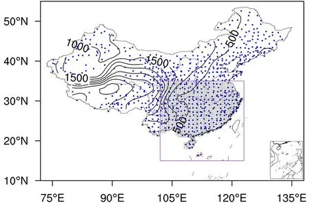
Fig. 1. Distribution of 756 observation stations over China(dots) and the altitudes of these stations (contours are from 500 m to 4500 m with intervals of 500 m). The purple box indicates southern China. Grid boxes of 0.5° × 0.5° in southern China are used to measure the extent of ECPFEs. Blue lines denote the Yellow River and Yangtze River. The inset in the lower right represents the South China Sea Islands.
Then, we calculate the areas of cold stations, precipitation stations, and freezing stations, separately. Since the 316 stations are nonuniformly distributed across southern China,it is difficult to quantify the area of cold stations. To measure the cold-station area, we divide southern China into 300 0.5° × 0.5° latitude/longitude grid boxes, as shown in Fig. 1.The cold-station area is represented by the total number of grid boxes that contain at least one cold station. The precipitation-station area and the freezing-station area are calculated in the same manner as the cold-station area.
Here, we define thresholds for the areas of cold stations, precipitation stations, and freezing stations. The area is identified as extensive if it exceeds the threshold. We adopt the 67th percentile (the upper tertile) as thresholds for the cold-station area and precipitation-station area, which are 116 and 43 grid boxes, respectively. It is observed that freezing weather occurs in a considerably smaller area than the cold area and the precipitation area. For example, the 67th percentile of the freezing-station area is only 6 grid boxes. Thus, we use the 85th percentile as the threshold for the freezing-station area, i.e., 10 grid boxes. The thresholds of the cold area, precipitation area, and freezing area account for 38.7%, 14.3% and 3.3% of the total area of southern China, respectively.
Finally, we define an ECPFE, as follows: An ECPFE is identified in southern China if the cold area, precipitation area, and freezing area concurrently exceed their respective thresholds for at least three consecutive days. The duration of three days is approximately the 80th percentile of the duration in which the cold area, precipitation area, and freezing area simultaneously exceed their respective thresholds (including one and two days).
According to the above procedure, a total of 109 ECPFEs are identified from 1951 to 2013 (Table 1, column 2).
3.1.2. Validation
To examine the robustness of the ECPFEs identified in this study, we first compare our results of a typical case of great influence in 2008 with those defined in previous studies (Tao and Wei, 2008; Zong et al., 2013). The well-known ECPFE episodes in early 2008, ranking 101st to 103rd in Table 1, are identified to begin on 13 January and end on 2 February 2008. The ending day of the ECPFE episodes in the current study (2 February) is the same as the date in a previous study (Tao and Wei, 2008). The current identification of the starting day of the ECPFE (13 January) basically agrees with the date (10 January) of the previous study (Tao and Wei, 2008). The difference possibly comes from the more critical areal thresholds in our definition.
Figure 3 shows the daily evolutions of cold-station area, precipitation-station area, and freezing-station area,respectively, from 10 January to 10 February 2008. The cold-station area (Fig. 3a) and freezing-station area (Fig. 3c)both exceed their thresholds during the entire period. In con-trast with these two areas, the precipitation-station area exhibits a more drastic variation in this period, during which it falls below the threshold three times (16, 23 and 24 January). The variation of precipitation-station area reflects that there are three ECPFEs: 13-15 January, 17-22 January, and 25 January-2 February (Table 1). In previous studies (Sun and Zhao, 2008; Tao and Wei, 2008; Zhao and Sun, 2008),there are four ECPFEs at the same time: 10-14 January,18-23 January, 25-28 January, and 30 January-2 February.The difference appears in the third period. By examining the daily evolution of the precipitation-station area (Fig. 3b),it can be seen that, although the precipitation area reaches a local minimum on 30 January, it is above its threshold. Meanwhile, precipitation of more than 2 mm ddominates in southern China during 29-31 January 2008 (Fig. 4). Therefore, the period from 25 January to 2 February should not be divided into two synoptic periods, according to the daily evolution of precipitation in southern China. This fact suggests that, on the whole, our identification of ECPFE episodes in 2008 is reasonable and in agreement with previous studies.

Table 1. Information on 109 ECPFEs. Units of duration and area are given in days and numbers of grid boxes (0.5° × 0.5°),respectively. An asterisk (*) denotes the events that were also identified by the NMC/CMA, and a double asterisk (**) denotes the events that were not identified by the NMC/CMA (Zong et al., 2013).
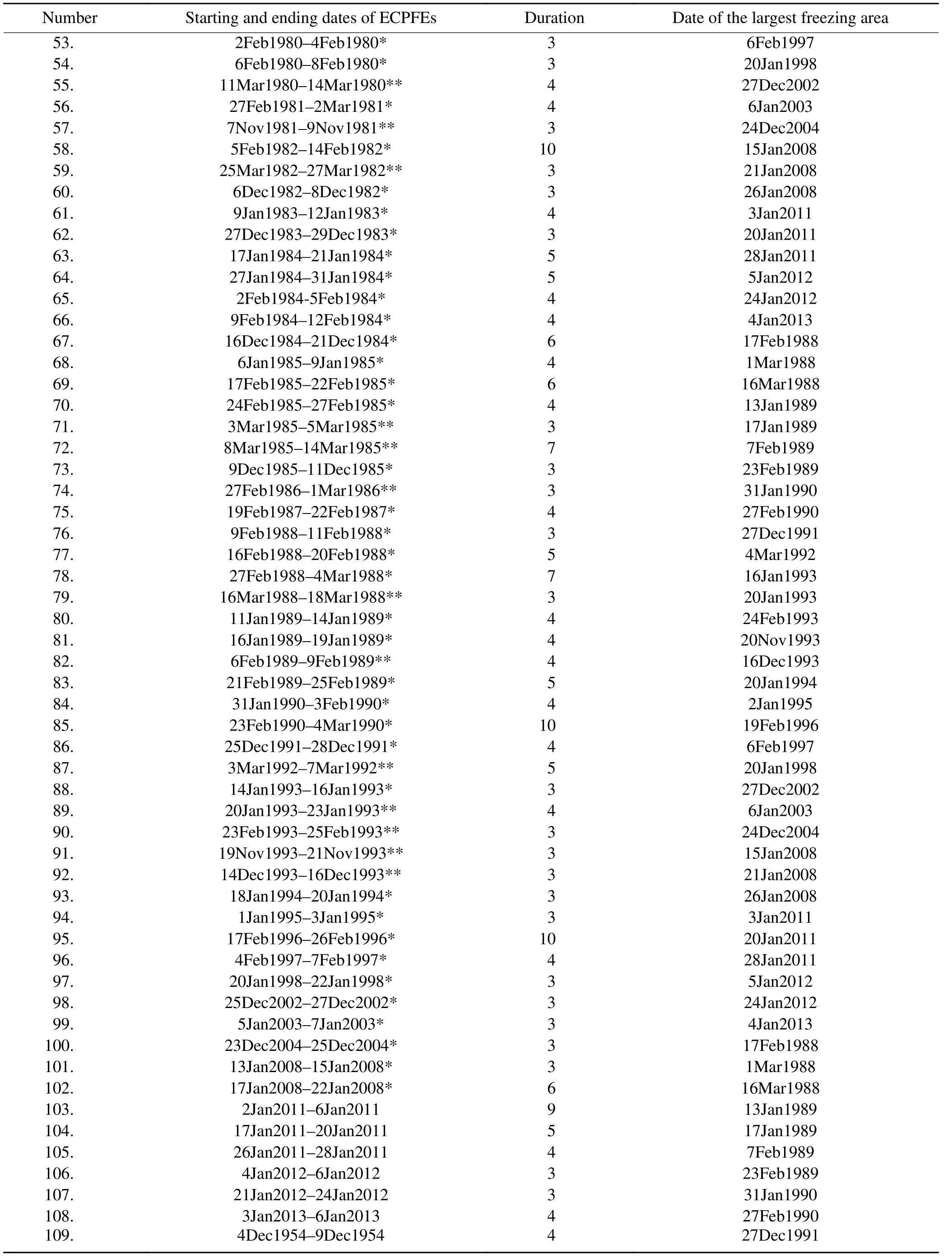
Table 1. (Continued.)
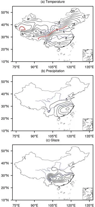
Fig. 2. Climatological mean (1961-2010) observational (a)surface air temperature, (b) precipitation, and (c) freezingweather frequency in extended winter (1 November-31 March). Isolines are drawn for every 2°C, 0.5 mm d-1, and 1%,respectively. Red lines denote the 0°C isotherm. Blue lines denote the Yellow River and Yangtze River.
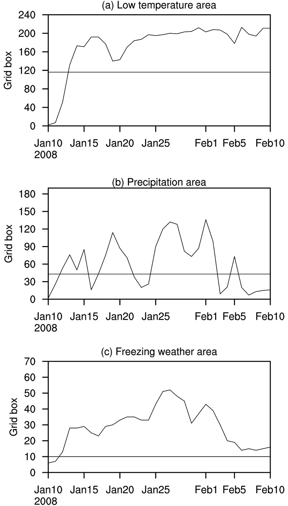
Fig. 3. Daily evolutions of (a) cold-station area, (b)precipitation-station area, and (c) freezing-station area,respectively, from 10 January to 10 February 2008. Black horizontal lines indicate the areal thresholds.

Fig. 4. Distributions of normalized temperature anomalies(units: °C; contours are from -4°C to 0.5°C with intervals of 0.5°C) and precipitation (shaded; units: mm d-1) on (a) 29 January 2008, (b) 30 January 2008, and (c) 31 January 2008.The stations with glaze (freezing weather) are indicated by red dots. Blue lines denote the Yellow River and Yangtze River.
Next, we compare our identified ECPFEs with those identified subjectively by the NMC/CMA (Zong et al., 2013).The NMC/CMA identified 62 ECPFEs in the period 1978-2008 (Zong et al., 2013), while we identify 54 ECPFEs in the same period (50th-103rd in Table 1). 40 out of 54 ECPFEs in our identification overlap with those by the NMC/CMA (Zong et al., 2013), as denoted by an asterisk in Table 1. Meanwhile, as shown in Table 2, a total of 28 ECPFEs identified by NMC/CMA (Zong et al., 2013)are not identified in this study. In five events (16th, 17th,21st, 24th, and 27th events in Table 2), the three areal threshold criteria and the requirement of three consecutive days are satisfied, but the period during which the cold area,precipitation area and freezing area simultaneously meet the areal threshold criteria is less than 3 days. In four events(11th, 12th, 13th and 22nd events in Table 2), each of the three areal threshold criteria and the requirement of three consecutive days are not satisfied concurrently. Especially, the 11th, 12th and 22nd events (Table 2) lasted for less than 3 days. In six events (5th, 8th, 18th, 19th, 20th and 25th events in Table 2), only two of the three areal threshold criteria are satisfied along with meeting the demand of at least three consecutive days; and in the remaining 13 events, only one of the three areal threshold criteria is satisfied as well as lasting for three consecutive days. Thus, the reason why the 28 ECPFEs identified by NMC/CMA (Zong et al., 2013)have not been identified in this study is primarily due to the strict criteria in our ECPFE definition.
On the other hand, as denoted by a double asterisk in Table 1, 14 ECPFEs in our identification are absent in the 62 ECPFEs identified by the NMC/CMA (Zong et al.,2013). This results mainly from the different lengths of winter used. As can be seen from Table 1, 10 of these events occur in November or late February to March.
The comparison of our results with an existing ECPFE identification demonstrates that, on the whole, the current identification of ECPFEs can be considered robust and reliable. The discrepancies found in the comparison result primarily from our strict areal threshold criteria in low temperature, precipitation and freezing weather. A longer length of winter also affects the number of ECPFEs identified.
3.2. Circulation features typical of ECPFEs
3.2.1. Case selection
According to the definition of an ECPFE, it is simply known as an extensive cold event with extensive precipitation and freezing weather. To depict the nature of an ECPFE, therefore, it is better to compare it with extensive cold events with less precipitation and less freezing (i.e.,ECEs), as well as with precipitation but with less freezing(i.e., ECE-Ps).
In an analogous way to ECPFEs (see subsection 3.1),an ECE is identified with an areal threshold criterion of cold stations and the requirement of three consecutive days in winter. Similarly, an ECE-P is identified with an areal threshold criteria of cold stations and precipitation stations and the requirement of three consecutive days in winter. To reduce the influence of seasonal variation of climatological background circulation, we choose the conventional winter(December-January-February, DJF) cases of ECPFEs,ECEs and ECE-Ps to configure their key features. As such,a total of 87 ECPFEs, 227 ECEs and 125 ECE-Ps are identified for the period 1951-2013.
According to the definitions of these three types of events, it is obvious that the ECEs contain the ECE-Ps, and the ECE-Ps also contain the ECPFEs. The relationships among the three types of events are illustrated in Fig. 5. To depict the key features of these three types of events, we select the total 87 ECPFEs, 127 ECEs excluding all of the ECE-Ps, and 40 ECE-Ps excluding all of the ECPFEs (see Fig. 5) to analyze their near-surface observational features and circulation characteristics. Note that an ECE may contain two or even more ECE-Ps. Hence, the number of ECEs excluding all ECE-Ps is 127, instead of 227 - 125 = 102.Besides, two ECE-Ps that occurred during 16 February to 1 March 1959 and during 23 February to 2 March 1969, are not included in the 125 DJF ECE-Ps. Thus, the number of ECE-Ps excluding all ECPFEs is 40, instead of 125 - 87 =38.
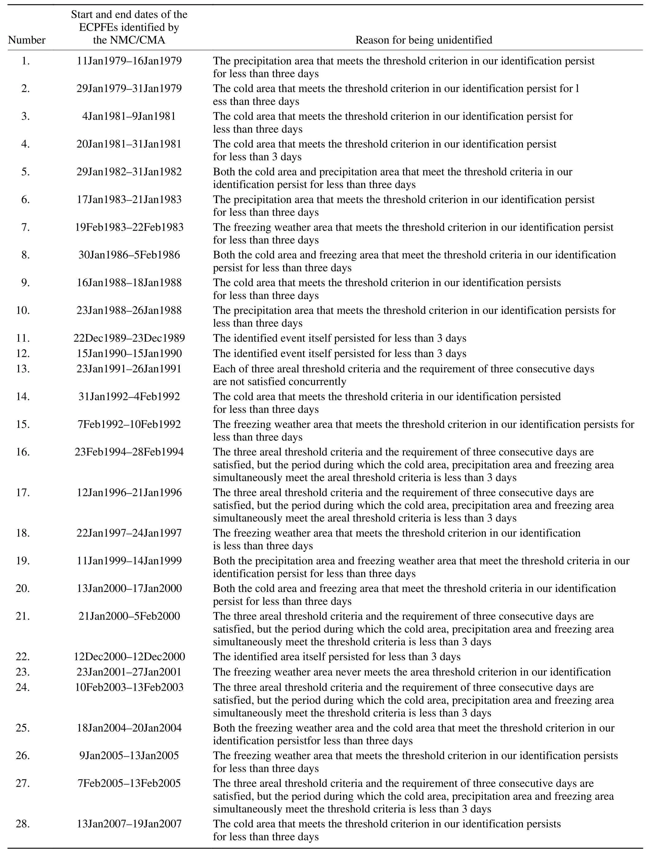
Table 2. The ECPFEs that are identified by the NMC/CMA (Zong et al., 2013) but not identified in the current study.
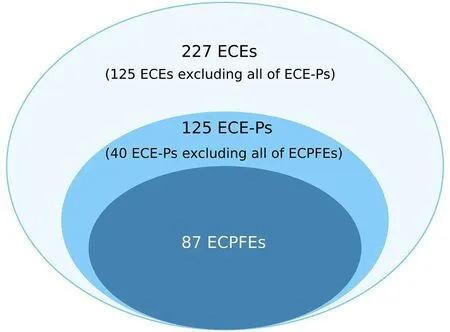
Fig. 5. Schematic diagram of the relationships among the three types of low-temperature events. There are 87 ECPFEs, 125 ECE-Ps and 227 ECEs during the DJF of 1951-2013.According to the definitions of the three types of events, the ECEs contain the ECE-Ps, and the ECE-Ps also contain the ECPFEs. There are 127 ECEs excluding all ECE-Ps, and 40 ECE-Ps excluding all ECPFEs.
3.2.2. Key features of near-surface observations
Figure 6 shows the composite fields of the normalized temperature anomalies, precipitation anomalies (in percentage), and freezing-weather frequencies averaged during the ECPFEs (left), ECEs (middle), and ECE-Ps (right). The ECPFEs are characterized by significant negative temperature anomalies in China, increased precipitation from the Yangtze River valley to southern China (Fig. 6b), and frequent freezing weather from southwestern China to the regions along the middle and lower reaches of the Yangtze River. The maximum frequency of freezing weather in the middle and lower reaches of the Yangtze River is up to 50%(Fig. 6c).
In contrast to the ECPFEs, the ECEs feature a weaker cold anomaly, decreased rainfall, and considerably less freezing-weather occurrence (Fig. 6d). For the ECEs, a precipitation deficit dominates over China (Fig. 6e) and the freezingweather frequency is below 5% in most areas (Fig. 6f).
For the ECE-Ps, the amplitude of the cold anomaly is equivalent to that of the ECEs and weaker than that of the ECPFEs (Fig. 6g). The precipitation is above normal in southern China (Fig. 6h). The freezing-weather frequency ranges between 5% and 10% in the middle and lower reaches of the Yangtze River (Fig. 6i).

Fig. 6. Composite fields of normalized temperature anomalies (top; contour lines are drawn for every 0.25 σ), precipitation anomalies in percentage (middle; contours are drawn for -0.5, 0.0, 0.5, 1.0, 2.0, 4.0, and 6.0), and the freezing-weather frequency (bottom; contours are drawn for 5%, 10%, 15%, 20% and 40%), averaged during ECPFEs (left), ECEs (middle),and ECE-Ps (right). Red dots denote that the composite anomalies are statistically significant at the 0.05 level.
3.2.3. Typical circulation features
Figure 7 shows the composite fields of averaged Z500 and the corresponding anomalies during the three groups of extensive cold events. Focusing first on the ECPFEs, a tilted ridge with significant positive height anomalies is situated over Eurasia north of 45°N, with the anomaly center residing around the Ural Mountains. At the same time, a tilted trough with significant negative anomalies is located over the 30°-45°N zone in East Asia. This configuration is reminiscent of the large-scale tilted ridge and trough pairing that is the crucial circulation pattern for extensive and persistent extreme cold events (Bueh et al., 2011a, b, 2018; Peng and Bueh, 2011, 2012; Bueh and Xie, 2015). The tilted ridges and troughs are more quasi-stationary than ordinary ridges and troughs, leading to more persistent cold air invading China (Bueh et al., 2011a, b; Peng and Bueh, 2012). This is consistent with the longer duration of ECPFEs.

Fig. 7. Composite fields of Z500 (contours; interval: 50 gpm)and the corresponding anomalies (shading) averaged during the (a) ECPFEs, (b) ECEs, and (c) ECE-Ps. Black dots show the t-test significance at the 0.05 level.
Unlike the ECPFEs, the ECEs are characterized by a zonal wave train circulation pattern (Fig. 7b). The ridge is displaced southeastward from the Caspian Sea to Lake Baikal with respect to that of the ECPFEs, while the East Asian trough is deepened over its climatological position. This zonal wave train pattern is a typical pattern for ordinary cold waves in East Asia (Park et al., 2011; Peng and Bueh,2012), which exhibit an obvious migrating feature. A pronounced zonal height gradient is observed over eastern China, which results in stronger northerlies that convey cold air into the southeastern coastal region of China.
Regarding the ECE-Ps (Fig. 7c), the circulation features a dipole pattern over eastern Asia, with a positive height anomaly over northeastern Asia and a negative height anomaly band from Tibet to Japan. In comparison with ECPFEs, the significant negative height anomaly extends further south into the Indochina Peninsula and thus favors a stronger northeastward moisture flux and a more active subtropical synoptic disturbance, inducing more precipitation in-situ.
Different mid- and high-latitude circulation anomalies may lead to different pathways of cold air. Hereafter, for brevity, 0 d refers to the starting day of the event and -N (N) d refers to N days before (after) 0 days. Figure 8 shows the evolution of △T24 for the three groups of cold events from-10 d to 1 d. Regarding the ECPFEs (left-hand column), at-10 d, there are significant negative △T24s to the north of the Caspian Sea where cold air accumulates. From -5 d to-3 d, a significant negative △T24 center exceeding -4°C dpropagates eastward to the east of Lake Baikal. From -1 d to 0 d, cold air sweeps southward to southern China. Significant cooling occurs in the middle and lower reaches of the Yangtze River and to the south of the Yangtze River. At 1 d,significant negative △T24s of less than -4°C dstill occur in southern China. The southward intrusion of cold flow leads to the propagation of the 0°C isotherm (the red lines in Fig. 8) from North China (-3 d) southward to the middle and lower reaches of the Yangtze River (-1 d) and then to the northern part of the Yangtze River (0-1 d). The invading cold air favors a cold layer of below 0°C in the lower troposphere over the increased rainfall region that turns the liquid precipitation to be refrozen when the raindrops fall to the ground and on exposed objects. Studies have shown that low-level cold air is one of the key factors for freezing rain and freezing weather (Li et al., 2008; Tao and Wei, 2008;Zhao and Sun, 2008).
In contrast with the ECPFEs, the negative △T24 of the ECEs intrudes southward from Lake Baikal to southeastern coastal China (middle column of Fig. 8), the so-called eastern route of cold-air intrusion. Although the negative △T24 of the ECEs is more intensive at -1 d than the ECPFEs’ counterpart, it is more transient and then absent at 1 d. Therefore, the troposphere is controlled by the cold air that is unfavorable for precipitation and freezing weather (Figs. 6d-f).

Fig. 8. Composite daily evolutions of ΔT24 (units: °C d-1) for the ECPFEs (left), ECEs (middle), and ECE-Ps (right). Black dots show the t-test significance at the 0.05 level. Red lines refer to the 0°C isotherm. Purple dashed lines denote 30°N.
Similar to the ECPFEs, the ECE-Ps also feature a southeastward incursion of negative △T24 from the Caspian Sea with a relatively weak amplitude (right-hand column of Fig. 8). Meanwhile, a moderately negative △T24 is advected southward from Northeast China in conjunction with southeastward negative △T24 incursion over southern China. However, the weaker amplitude of negative △T24 is incapable of producing a below 0°C layer near the ground(indicated by the 0°C isotherm). In this situation, precipitation tends to prevail over southern China with moderate freezing weather (Figs. 6g-i).
Different circulation anomalies over the mid and high latitudes during these three types of cold events correspond to different cold-air sources and pathways. The large-scale tilted ridge and trough facilitate the propagation of cold air from the north of the Caspian Sea to South China during an ECPFE. The zonal wave-like ridges and troughs during an ECE lead to the southward propagation of cold air from Lake Baikal. The negative height-anomaly band extending from Tibet to Japan during an ECE-P corresponds to weak cold-air incursion from the Caspian Sea to South China.
The near-surface cold layer and warm layer aloft are the key factors for freezing rain in China (Sun and Zhao,2008; Zhao and Sun, 2008; Deng et al., 2012). In January 2008, the warm layer in the middle and lower troposphere was found to be closely related to the abnormal southerly wind field (Zong and Ma, 2011). Next, we turn our attention to examining the subtropical circulation system and vertical structure of wind and temperature during ECPFEs, and compare the results with those of ECEs and ECE-Ps.
Figure 9 shows the composite wind and temperature anomaly fields at three lower-tropospheric pressure levels for the ECPFEs. At 700 hPa (Fig. 9a), there are significant westerly anomalies near 25°N, suggesting an intensification of the southern branch of the westerly jet. Meanwhile,an anticyclonic anomaly stays over the western Pacific Ocean. The enhanced southern branch of the westerly jet and the anticyclonic anomalies lead to significant southerly wind anomalies prevailing to the south of 35°N. The anomalous southwesterly airflow transports warm air from the southeast of the Tibetan Plateau to the Yangtze River basin (Fig. 9d),resulting in a warm layer. In the meantime, the large-scale tilted ridge and trough in the ECPFEs foster significant northerly anomalies over southern China at 850 hPa and 925 hPa(Figs. 9b and c), favoring a southward invasion of cold air(Figs. 9e and f), and hence the formation of a near-surface cold layer.
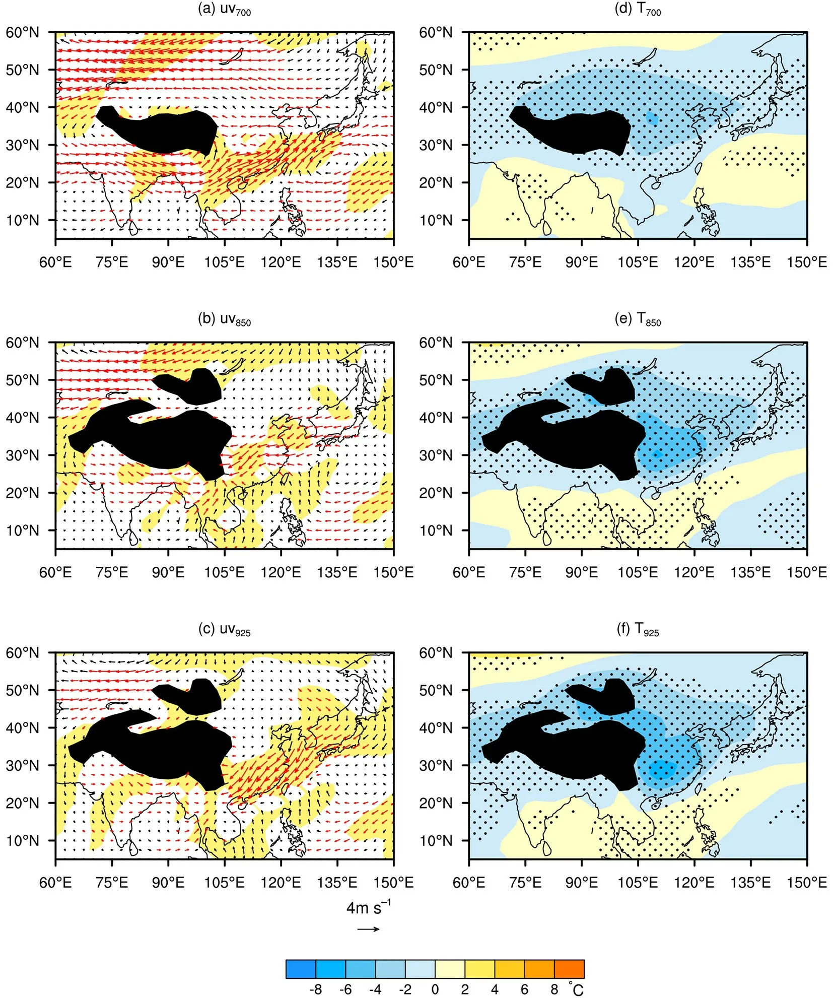
Fig. 9. Composite wind anomalies (left; units: m s-1) and temperature anomalies (right; units: °C) at 700 hPa(top), 850 hPa (middle) and 925 hPa (bottom) averaged during 87 ECPFEs. The dots indicate regions where the composite temperature anomalies are significant at the 0.05 level. Red vectors show that the composite zonal wind anomalies are significant at the 0.05 level. The yellow shading denotes areas where the composite meridional wind anomalies are significant at the 0.05 level. The black shading denotes topography higher than 3000 m in (a, d) and 1500 m in (b, c, e, h).
Figure 10a displays the pressure-latitude cross sections (averaged over 107.5°-120°E) of composite temperature and wind anomalies for 87 ECPFEs on the days of the largest freezing-station area (fourth column of Table 1).Around 25°-30°N, the significant warm flow glides up over shallow cold air, resulting in an inversion layer and hence the frequent freezing rain (Fig. 6c). Thus, during ECPFEs,the enhanced southern branch of westerlies and the anticyclonic anomalies over the western Pacific lead to significant southwesterlies, an inversion layer, and the favorable environment of freezing rain.
For the ECEs, significant northerly anomalies prevail over eastern China in the middle and lower troposphere(Figs. 11a-c). Their intensities are stronger than those in ECPFEs (Figs. 9a-c). The northerly anomalies lead to the invasion of cold and dry air from the north (Figs. 11d-f). In addition, there are significant easterly anomalies near 25°N,and the southern branch of the westerly jet is weakened.The vertical cross section of wind anomalies of 107.5°-120°E (Fig. 10b) shows that significant descending air flows control from 20°N to 40°N on the days of the largest cold-station area. The northerly anomalies and descending air flows correspond to little freezing weather and precipitation in the ECEs (Figs. 6e and f).
The composite wind and temperature anomalies at 700,850 and 925 hPa for 40 ECE-Ps (shown in Fig. 12) are similar to those for ECPFEs. At 700 hPa, the southern branch of the westerly jet enhances, and an anomalous anticyclonic center over the east of the Philippines is located to the south of that in ECPFEs (Fig. 9a). Regions to the south of the Yangtze River are controlled by southerly anomalies. At 850 hPa and 925 hPa, northerly anomalies prevail over southern China. The southerly anomalies at 700 hPa and the northerly anomalies at lower levels are weaker than those for ECPFEs (Figs. 9a-c). The weaker cold air cannot help form frozen (below 0°C) layers near the ground. In addition, due to the weaker southerly anomalies at 700 hPa (Fig. 12a), the warm layer for ECE-Ps on the days of the largest precipitation-station area (Fig. 10c) is shallow and shifts southward compared to those in ECPFEs (Fig. 10a). There is a close relationship between the freezing-rain area and the intensity of the inversion layer (Zong and Ma, 2011). Therefore, there is extensive precipitation but less freezing weather in ECE-Ps.
These results suggest that the southern branch of the westerlies and the anomalous anticyclonic circulation over the western Pacific are the important subtropical circulation systems for ECPFEs in southern China. The active disturbances in the southern branch of the westerlies and the anomalous anticyclonic circulation over the western Pacific lead to the significant southwesterly anomalies in the mid-tropospheric layer over southern China. The southwesterly anomalies help form the inversion layer, which is crucial for the freezing rain. In ECEs, the southern branch of westerlies is weakened. Strong cold and dry air invades southern China from the north. Northerly anomalies prevail over southern China, resulting in less precipitation and freezing rain. In ECE-Ps, the active subtropical systems and the weak cold air lead to less freezing rain.
4. Conclusions and discussion
By using observational and reanalysis data, the ECPFEs in southern China are defined objectively, and their circulation characteristics are studied. The main conclusions are as follows:

Fig. 10. Pressure-latitude cross sections (averaged over 107.5°-120°E) of composite temperature anomalies (shaded; units:°C) and wind anomalies (arrows; meridional wind anomalies: m s-1; pressure vertical velocity: -1 hPa h-1, negative values denote upward vertical velocity) on the days of (a) the largest freezing-station area in the ECPFEs, (b) the largest cold-station area in the ECEs, and (c) the largest precipitation-station area in the ECE-Ps. The purple arrows indicate composite vertical motions that are significant at the 95% confidence level. The black dots show the t-test significance of composite temperature anomalies at the 0.05 level.
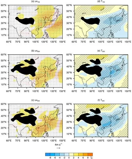
Fig. 11. As in Fig. 9 but for 127 ECEs.
(1) An ECPFE is defined if the low temperature area, precipitation area, and freezing area concurrently exceed their respective thresholds for at least three consecutive days.The 67th percentile is adopted as the threshold for the coldstation area and precipitation-station area, respectively,while the 85th percentile is used as the threshold for the freezing-station area. The areal thresholds of the cold-station area, precipitation-station area, and freezing-station area account for 38.7%, 14.3% and 3.3% of the total area of southern China, respectively. Comparison of our results with those of an existing ECPFE identification demonstrates that,on the whole, the current identification of ECPFEs can be considered robust and reliable.
(2) An ECPFE in southern China occurs with a specific pattern of circulation anomalies in the mid, high, and low latitudes, as follows: (a) a large-scale tilted ridge and trough at mid and high latitudes play an important role in persistent cold-air invasion to southern China; (b) around 700 hPa, an active southern branch of the westerlies and an anomalous anticyclonic circulation over the western Pacific jointly favor warm and wet air conditions over southern China; and (c) stable cold air from the north and warm and moist air from the south converge, facilitating a favorable environment for the concurrence of extensive low-temperature, precipitation and freezing weather.

Fig. 12. As in Fig. 9 but for 40 ECE-Ps.
(3) The circulation anomalies during ECPFEs are distinct from those during ECEs and ECE-Ps. During ECPFEs,the convergence between the remarkable near-surface northerlies and the strong southerlies at 700 hPa leads to extensive and persistent precipitation and freezing weather in southern China. In contrast, during ECEs, the strong cold-air invasion from the north does not favor precipitation and freezing weather in southern China. During ECE-Ps, both the southerly anomalies at 700 hPa and the near-surface northerly anomalies are weaker than those during ECPFEs.Although extensive precipitation occurs in this situation, the quite weak cold-air activity does not favor a frozen layer near the ground and hence freezing weather in-situ.
Due to the peculiar nature of the local topography, the freezing-rain frequency in Guizhou is the highest in China(Deng et al., 2015). Aside from the abovementioned largescale circulation anomalies, there can be multiple physical mechanisms for freezing weather in Guizhou.
Extensive disastrous weather events affect health, economics, and infrastructure, leading to higher potential risks(Añel et al., 2017; Zscheischler et al., 2018). During midlate January 2008, southern China experienced ECPFE episodes at record levels since the advent of reliable record keeping in the region (Tao and Wei, 2008). These events caused an enormous amount of damage to the lives and property of people in southern China, which has attracted great public attention and garnered extensive scientific interest (Tao and Wei, 2008; Wen et al., 2009; Zhou et al., 2009). For a systematic study of ECPFEs, however, an objective definition is thus far lacking. In fact, in the current study, we have made a concerted effort to present an objective definition of ECPFEs in terms of their extensive low temperatures, precipitation, and freezing weather. Our definition of ECPFEs is somewhat analogous to the definition of compound extremes (Martius et al., 2016), both of which are based on multiple factors.
Previous studies have revealed that, with the weakening of the Siberian high, a weaker East Asian winter monsoon induces warmer and wetter conditions in eastern China(Li and Bates, 2007). Results from data analyses and numerical simulations show that both the trough over the Bay of Bengal and the western Pacific subtropical high play crucial roles in facilitating the moisture conditions for precipitation in southern China (Li et al., 2007). As shown in section 3.2.1, there are 227 ECE-Ps and 109 ECPFEs identified in the years 1951-2013. Clearly, sometimes, ECE-Ps are not necessarily accompanied by extensive freezing weather. By comparing the circulation characteristics of ECPFEs with those of ECEs and ECE-Ps, we arrive at some meaningful implications. The different allocations for circulation patterns in the different latitudinal bands result in different types of cold events in southern China. As the circulation anomalies over the mid and high latitudes and in the subtropics are in a convergence state, a favorable environment then forms for an ECPFE. When the northerly flow over midlatitudes is sufficiently strong, it favors the occurrence of an ECE. If the southerly flow in the subtropics is sufficiently strong, an ECE-P tends to occur.
The authors are very grateful to the two anonymous reviewers and the editors for their critical and constructive comments and suggestions. The authors benefited from the discussion with Profs. Liren JI and Shuqing SUN, and Drs. Jie WEI and Haifeng ZONG at the Institute of Atmospheric Physics,Chinese Academy of Sciences. This research was funded by the National Natural Science Foundation of China (Grant Nos.41975072 and 41675086) and the National Science and Technology Support Program of China (Grant No. 2015BAC03B03).杂志排行
Advances in Atmospheric Sciences的其它文章
- Seasonal Forecast of South China Sea Summer Monsoon Onset Disturbed by Cold Tongue La Niña in the Past Decade
- Assimilation of Doppler Radar Data with an Ensemble 3DEnVar Approach to Improve Convective Forecasting
- Profiles and Source Apportionment of Nonmethane Volatile Organic Compounds in Winter and Summer in Xi’an, China, based on the Hybrid Environmental Receptor Model
- High-resolution Simulation of an Extreme Heavy Rainfall Event in Shanghai Using the Weather Research and Forecasting Model: Sensitivity to Planetary Boundary Layer Parameterization
- Precipitation Microphysical Processes in the Inner Rainband of Tropical Cyclone Kajiki (2019) over the South China Sea Revealed by Polarimetric Radar
- Variations in Wave Energy and Amplitudes along the Energy Dispersion Paths of Nonstationary Barotropic Rossby Waves