Coastal Environmental Changes and Management in China in the Context of Global Changes and Human Activities
2019-08-23YunfengZHANGYingyingCHEN2XiaobinHUA3ShiqingYANLiliZOU
Yunfeng ZHANG*, Yingying CHEN2, Xiaobin HUA3, Shiqing YAN, Lili ZOU
1. Research Institute of Jiangsu Coastal Development, Yancheng Teachers University, Yancheng 224007, China; 2. School of Geography, Geomatics and Planning, Jiangsu Normal University, Xuzhou 221116, China; 3. School of Geography, University of Otago, Dunedin 9016, New Zealand
Abstract Coastal zone is the complex area with intense sea-land interaction. There are various types, complex environments and developed economy in coastal area of China. Under the influence of global change and human activities, the ecosystem of coastal zone is vulnerable and has sensitive response to environment changes. The environmental problems of sea-level rising have attached close attention by countries all over the world. As far as regions concerned, relative sea-level rising is more important than theoretical sea-level rising. The relative sea-level rising has resulted in series of environment disasters in coastal area of China, such as coastal erosion, seawater invasion, and floods in coastal lowlands, etc. The flux of sediments transported by rivers into sea is the main material source of marine pollution. The human activities are controlling factors of variations in river sediment loads. Under the influence of high strength development in the upstream region, the results are that the reduction of seagoing sediments in main rivers of China, and damage of coastal material balance. Land-based pollution is the main source of marine pollution. With rapid economic development in China’s eastern coastal, pollutants flux into sea increase gradually. The results are that the environmental quality and seawater quality of marine have being deteriorated and pollution is serious increasingly. To meet the land demand of industrialization and urbanization, the sea reclamation has become an effective means to alleviate the contradiction between human and land in coastal area of China. This leads to large-scale reduction of coastal wetland area, and the heavy losses of ecological service value of coastal wetland. To face the environmental changes in coastal area of China and solve the contradiction among population, resources, environment, development, it is required to set up the system concept of man-land-sea relationship, so as to achieve sustainable development. The feasible measures include improving coastal management system, strengthening integrated basin management, attaching importance to construction of the coastal environment engineering, and raising the environmental monitoring and early warning level.
Key words Costal areas, Environmental changes, Human activities, Integrated management
1 Introduction
Coastal zone is a complex zone with intense sea-land interaction. It is an ecologically fragile area with extremely sensitive response to environmental changes under the influence of global changes and human activities. Sea level rise caused by global warming means increase of global base level of erosion. Since the 1950s, global sea level has been rising at an increasing speed[1], and by 2100, the sea level will have increased by 0.5-1.4 m[2]. The sea level rise leads to coastal erosion recession, seawater invasion, submerged coastal lowland and frequent disasters, which have posed a severe challenge to the environmental safety for human survival and the living quality of humankind[3]. Tidal sediment carried by rivers from the land is the main source of coastal materials. High strength development of valleys, especially reservoir building in the valleys, leads to substantial reduction in tidal sediment, which breaks the original material balance in coastal zones[4-6]. Densely populated coastal zone is rich in resources with highly-developed economy. About 3/4 of big cities and over 50% of the world population are in coastal area within the distance of 200 km to the coast[7]. Constantly increasing human activities have brought extreme impact and destruction to the environment of coastal zones. On the one hand, marine ecosystem diversity of the coastal zone shows the tendency to deteriorate[8], such coastal wetlands ecosystem, such as mangrove, coral reef, tidal bank, outfall,etc, is lost and degenerates in large areas[9]; on the other hand, marine environmental pollution becomes increasingly worse as coastal economy develops, seawater quality degrades, "dead areas" that not suitable for living creatures to live in marine environment tends to increase constantly[10].
The coastal zone in mainland China starts from the entrance of Yalu River in Liaoning Province to the north and reaches the estuary of Beilun River in Guangxi Zhuang Autonomous Region to the south. Coastal area is densely populated with developed cities. This area covers 13% of national area with more than 40% of population and contributes over 60% to the national economy output value, and it has become one of the regions with the highest economic vitality around the world. The coastal area has achieved rapid development, but it puts heavy pressure on coastal environment: firstly, rapid development of heavy industrialization in the coastal area leads to tidal sediment of pollutants from the land grows prominently, which makes coastal environmental quality degenerate[11-12]; secondly, to meet the needs of land use by the port, industrial and urban development, large-scale sea reclamation makes the ecosystem of coastal wetlands degrade severely[13].
Under dual influence of global changes and unreasonable human activities, the coastal zone of China has become one of the most sensitive regions which are affected by environmental change and disasters in the world. As one of core plans of International Geosphere-Biosphere Program (IGBP) and International Human Dimensions Program (IHDP), the final aim of the study of sea-land interactions of coastal zone is to evaluate and predict evolution of coastal environment under the influence of climate change, sea level change and human activities through research on sea-land interaction of coastal zone, and provide scientific basis for integrated management and sustainable development of coastal zone[14]. Therefore, to identify significant environmental change and carry out the research on environmental variation of coastal zone is of important significance for protecting coastal environment, reasonably developing and utilizing coastal resources, as well as developing social economy of the coastal zone in a sustainable way.
2 Coastal development profile of China
China’s coastal zone is located in the intersection area of the largest continent and ocean (Eurasia and the Pacific), with mainland coastline of almost 18 000 km and island coastline of 14 000 km. It has various coastal types and ecological kinds, complex coastal environmental conditions and beach evolution and rich natural resources and advanced social economies[15-17].
2.1 Various types of sea coastFrom the north to the south, the coastal zone of China spans different geographical structures, geomorphic units, and climatic zones, and it provides conditions for all kinds of coastal development. Moreover, dual interactions of inflow and sediment from almost ten thousand rivers emptying into the sea, such as the Yangtze River and Yellow River, coastal biotic succession as well as human activities,etc., forms complex and various coastline types and coastal ecological systems in mainland China. Coastline of stone and gravel is mainly distributed in Liaoning, Shangdong Peninsula, and most sections in southeastern coastal area and coastal areas in South China; muddy plane coastline is mainly distributed in Bohai Sea Gulf, Laizhou Sea Gulf, coastal plain of Jiangsu, and the delta section of Yellow River, the Yangtze River, Min River, Han River and Pearl River; biological coast dominated by mangrove and coral reef is distributed in coastal zone and islands in South China.
2.2 Complex coastal environmentThe coastal zone of China spans a large length from the north to the south with greatly different climates and geomorphic types in different sections. Mutual interactions between external factors, such as a large number of materials from land-based source and marine hydrological power, and special climates and terrain in different sections,etc. forms complex environmental conditions of coastal evolution of China. The Pacific tide enters Chinese offshore, it turns, reflects and becomes deformed due to the influence of offshore shapes and coastal islands, leading to corresponding changes of tidal systems, and shapes complex tide and current systems along the coastline. Tide types and current system and related factors vary greatly in different territorial waters, and these types and factors of different sections also are distinctly different in the same territorial waters.
2.3 Advanced social economyThe coastal zone of China spans 14 provinces, cities, autonomous regions (Liaoning, Hebei, Beijing, Tianjin, Shandong, Jiangsu, Shanghai, Zhejiang, Fujian, Guangdong, Guangxi, Hainan, Hong Kong, Macao, and Taiwan). The coastal zone possesses geographical positions with abundant resources and a long history of development. It has always been a densely populated zone with the highest level of urbanization and the best developed economic zone As the advancing front of opening up and an important base of marine development, social and economic development level occupies the forefront of the country, and becomes the most vigorous area in economic growth in China. The coastal zone had a total population of 580 million (43.02% of China’s total population) and GDP of 24 594.42 million yuan (61.31% of China’s GDP) in 2010. Besides, as coastal development strategy further carries on, marine economy develops rapidly, and in 2009, the marine total output value was 3 227 760 million yuan (9.5% of national output value), and 15.6% of total output value of the coastal zone, in which coastal tourism, maritime transportation and marine fishery was 34%, 24%, and 19% of marine economy, and they become the top three leading industries of marine economy.
3 Environmental changes of coastal zone of China
The factors influencing environmental changes of the coastal zone can be divided into operation of nature and human activity. The operation of nature can change the way of human activity, and affect offshore environmental problems; when human activity exceeds the threshold value of environmental holding capacity, it will place a premium on natural disasters, and cause large-scale environmental catastrophe. As industrialization and urbanization of the coastal zone in China develops rapidly, the impact of human activity on offshore environment has played a more and more significant leading role.
3.1 Relative sea level rise and influenceChina’s sea level change is a part of global sea level change, during recent years, theoretical absolute sea level and regional relative sea level has been discriminated, which emphasizes relative sea level rise used for evaluating dangers and losses of China’s coastal zone when sea level rises[18]. The land subsidence of the coastal zone in China is severe, especially in the Yellow River Delta, the Yangtze River Delta, and Pearl River Delta, due to such human factors as urban construction and over extraction of groundwater, and the rise speed of the regional relative sea level is far larger than that of the global sea level. According to the latest data of Sea Level Gazatte in 2017 from National Bureau of Oceanography, the sea level of the coastal zone in China was higher by 58 mm than perennial average sea level in 2017 (according to the appointment of Global Sea Level Observing System, average sea level in 1975-1993 is decided as perennial average sea level (abbr. as perennial); the average monthly during the period is decided to be perennial average monthly sea level). General sea level of the coastal zone in China over the past 30 years shows a rising trend in an undulating way with annual average rise speed of 3.3 mm (Fig.1).
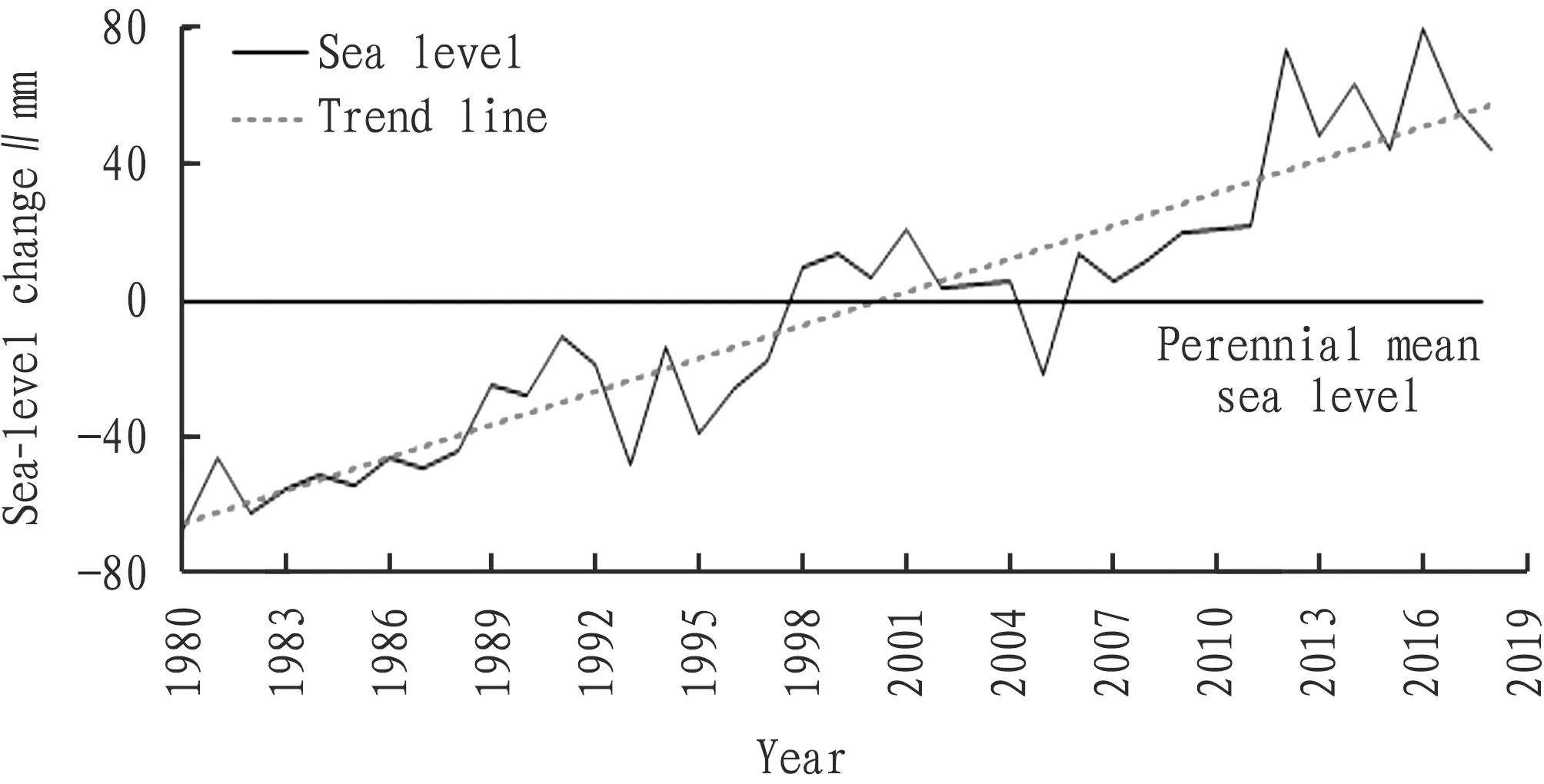
Fig.1 Sea-level change curves in coastal area of China
According to statistical analysis from tide station in China’s coastal line, the decadal sea level of the coastal zone in China is rising significantly. Between 2001 and 2010, the general average sea level in the coastal zone in China was very high in history, which was higher than average sea level from 1991 to 2000 by 25 mm, and higher than average sea level from 1981 to 1990 by 55 mm. Influenced by regional climatic change, the decadal sea level change of provinces (autonomous regions and municipalities) in the coastal zone in China shows a significantly regional difference (Fig.2), including the sections with the most obvious rise in coastal zones of Hainan, Jiangsu and Shangdong, next to these are the coastal zones of Liaoning, Tianjin, Shanghai, Zhejiang, Fujian, Guangdong and Guangxi, and the coastal zone of Hebei rose with the slowest speed.
The sea level rise has caused environmental disasters in the coastal zone in China[19], including offshore erosion aggravation, sea water erosion, lowland submersion in coastal zone, storm tide disaster,etc. The disastrous effect affects directly sustainable development of social economy in the coastal zone, and especially threatens compacting zone of cities in the plain in the coastal zone in China in a greater way. The Pearl Delta, the Yangtze River Delta, offshore areas in northern Jiangsu, Yellow River Delta, Bohai Sea Gulf region and Laizhou Sea Gulf are main ecologically fragile regions of the coastal zone in China, and it is predicted that the relative sea level rise extent in the Pearl River Delta is 500-600 mm, in the Yangtze River Delta it is 600-800 mm, in the Yellow River Delta it is 400-500 mm, in Tianjin region it is 700-900 mm, and it is 400-500 mm in the Liao River Delta[20]. Under the conditions of current tide and flood control, in the three main fragile regions, that is, the Yellow River Delta, the Yangtze River Delta and Pearl River Delta, landmass and cities will be submerged (Table 1). An overall planning will have to be made for the coastal zone of China and the national economy will be severely frustrated[21].
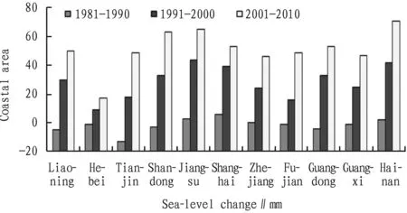
Fig.2 Inter-decadal variation of sea-level in coastal area of China
Table 1 Losses under the influence of relatively rising sea levels in coastal areas of China

RegionSea level rising∥mmInundated area∥km2Economic loss∥108 yuanSea wall maintenance cost∥108 yuanYellow River Delta30021 0105895.665023 1006188.1Yangtze River Delta3008981303.265027 24141716.5Pearl River Delta300115313617.665013 45341629.1
3.2 Reduction and influence of sediment loads of riversSediment inflow of rivers is a significant surface process. Sediment production and transport, as well as response of estuary delta have become an important content of the research on sea-land interaction. The drainage area of rivers emptying into the sea accounts for about 44.9% of the total area of the whole country. Before the 1980s, the average inflow runoff emptying into the sea of the accumulated year was 1 815 244 million m3, accounting for 4.6% of the total inflow runoff of rivers in the world, 69.8% of the total flow of rivers across China, and 73% of the average annual outflow runoff of China; the average annual inflow sediment discharge of rivers across the country was about 2 000 million t, accounting for 11.5% of inflow sediment discharge in the world, including, inflow sediment of the Yellow River was the top among rivers, which was 64.8% of all, followed by the Yangtze River, about 25%[22], and these materials mostly settles in the estuary delta, and some are brought to the depth of the basin by the current.
The main estuaries in China and other various estuaries in the world are all faced with remarkably diminishing tidal sediments. The decreasing sediment discharge of rivers in China began in the 1970s, and the decreasing trend became much obvious after the 1980s[23-24]. According to the statistical data of annual precipitation, annual runoff, and annual sediment discharge of tidal rivers, the analysis of historical changes of main tidal river flow and sediment of China, as shown in Fig.3, Firstly, the tidal sediment of main rivers over the past 50 years shows a trend to reduce, while sediment discharge over the past ten years is lower than the average annual discharge. Secondly, the tidal rivers can be roughly classified into three types according to changes of flow and sediment: sediment decreases while flow stays the fundamental invariant, both flow and sediment decrease, and flow and sediment almost diminish. Besides, three obvious characteristics of phased changes exist in the time distribution, and two obvious inflections occur in about the year 1968 and 1980; and three-year and ten-year cyclic fluctuations also exist. Obvious regional differences exist in spatial distribution, decline of regions differs, no obvious shift occurs in annual runoff in the Huai River and rivers in the south, annual sediment decreases significantly; annual runoff and annual sediment discharge of rivers in the south of the Huai River decrease obviously.
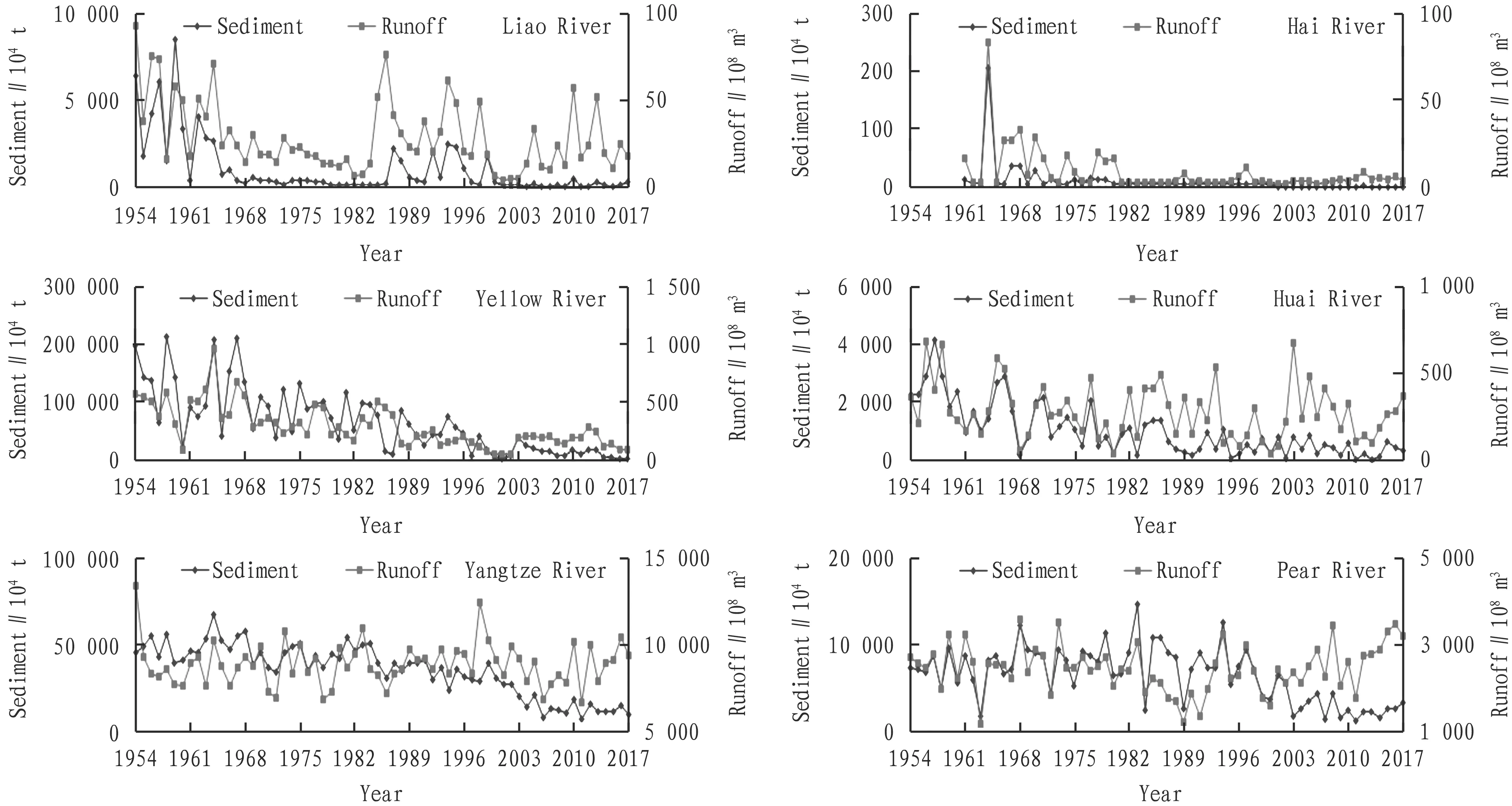
Fig.3 Trends of sediment and runoff of the main rivers in China
The decrease of tidal sediment of rivers is influenced by climatic change and human activities, while human activities play a more and more important role in leading production and transport of sediment[25]. The adjustment of reservoir and dam building in the valley in runoff and detainment of sediment will reduce tidal flow and sediment; hence, the estuary delta stretches slowly or suffers from erosion. Since 1960, the first drying up occurred in the Yellow River, the drying up became more and more serious in the lower reaches, which leads to sharp decrease of tidal sediment. From the 1950s to the 1990s, the annual average tidal sediment flux of every decades of the Huanghe River was 1 320 million t, 1 089 million t, 898 million t, 639 million t, and 418 million t, respectively and tidal sediment flux of the 1990s was only 31.7% of the 1950s, which is very astonishing[26]. The reduction of tidal sediment of the Yellow River directly affects the reclamation of Yellow River Delta (Table 2). The development and evolution of the Yellow River Delta are restrained by tidal flow, sediment conditions and marine dynamic actions. Under the condition of rich river flow and sediment, accumulation rate of the delta is far greater than erosion rate of marine dynamics and the coastline stretches constantly to the sea; when the river sediment decreases or even breaks off, marine dynamics becomes the leading factor of coastline evolution, and the coastline gradually erodes backwards under the pressure of tides and currents[27].
Table 2 The flux of the Yellow River into sea and evolution process of delta in different periods

3.3 Remarkable increase of tidal pollutantAs stated in Environment Kuznets Curve (EKC) hypothesis, the economic growth and environmental pollution takes on a curve linear relationship of U-shaped upside down which increases first and decreases later[28]. Since the reform and opening-up, the economy in the coastal zone in East China grows at a high speed, the comprehensive strength remarkably increases, but resource and environmental quality slides down at the same time, it is still in the rise stage of EKC curve, that is to say, the environmental pollution grows in pace with the economic development level[29].
Land-based pollution is the main source of marine pollutants. With high pressure activity of mankind and continual rapid economic growth of the coastal zone, large quantity of industrial and agricultural waste water and domestic sewage pouring into the sea, the marine has been polluted more and more seriously. In recent ten years, main rivers emptying into the sea carry a large number of pollutants from land-based source, leading to the surging rise of total quantity of pollutants emptying into the sea (Fig.4). It grew from 6.2 million t in 2003 to 15.66 million t in 2017, growing annually by 9.2%. The result of monitoring main pollutants of key rivers emptying into the sea, such as the Yellow River, the Yangtze River, the Pearl River shows that, pollutants carried by rivers are mainly Chemical Oxygen Demand (CODCr) and nutrient salt (nitrogen, phosphorus), and next to it is petroleum, heavy metal, arsenic,etc. (Fig.5). In 2017, the quantity of pollutants carried by 110 main rivers in China was respectively: CODCr 13 300 000 t, ammonia nitrogen (calculated by nitrogen) 150 000 t; total phosphorus (calculated by phosphorus) 230 000 t, petroleum 50 000 t, heavy metal 10 000 t (including copper 2 826 t, lead 445 t, zinc 6 974 t, cadmium 105 t, and mercury 49 t), and arsenic 2 761 t.
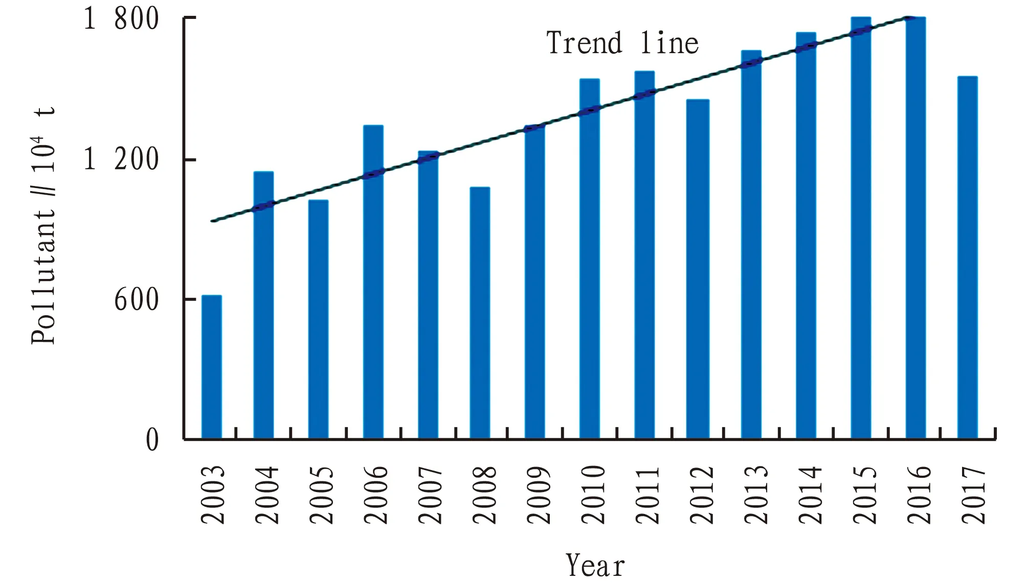
Fig.4 Total amount of land-based pollutants into sea in coastal area of China
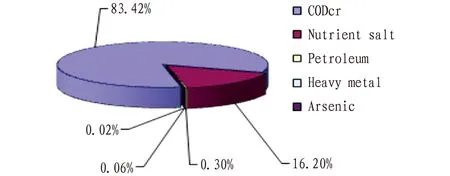
Fig.5 Main types of land-based pollutants into sea in coastal area of China
In the recent ten years, the rise of total quantity of pollutants emptying into the sea in the coastal zone has put much pressure on the marine environment, while the contaminated area remains high, and marine environmental quality has not be effectively improved (Fig.6). The oceanic area lower than national first-class sea water quality standard in 2017 was about 165 960 km2, the areas of second-class, third-class and fourth-class and inferior fourth-class water quality were 60 900, 33 490, 24 260 and 47 310 km2, respectively. The total oceanic area lower than the national quality standard of first-class sea water increased compared with 2001, including, the increase of inferior fourth-class water area of about 14 720 km2from 32 590 to 47 310 km2, in which the regional area of inferior fourth-class water quality of Bohai Sea, the Yellow Sea, East China Sea and South China Sea was 3 690, 3 840, 34 510, 5 270 km2, respectively. Main pollution areas lie in the offshore waters of the coastal zone in large and medium-sized thickly populated cities with centralized industrial parks, including the northern offshore of the Yellow Sea, Liaodong Sea Gulf, Bohai Sea Gulf, Laizhou Sea Gulf, entrance of the Yangtze River, Hangzhou Sea Gulf, entrance of the Pearl River, and offshore waters of some large and medium-sized cities, which are fairly developed area with higher industrial concentration in the coastal zone of China.
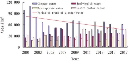
Fig.6 Seawater quality change trends in offshore sea of China
3.4 Severe degradation of coastal wetland ecosystemsWetland, forest and ocean are named as the three ecological systems on earth. They are of great significance to protect biological diversity, keep ecological balance and promote economic development. China is one of the countries with the widest and the largest area and of the most various wetlands types. The current wetlands (including coast, estuary, rivers, lakes and swamps) cover an area of about 38 485 500 ha, accounting for 4% of the whole national area, including coastal wetlands of 5 941 700 ha[30]. With the population growth and social development at top speed of the coastal region in East China, sea reclamation becomes an important tool to mankind for expanding living spaces to the oceans and to relieve man-land contradiction of the coastal zone. Reclamation is the main reason for large reduction of coastal wetlands, and global offshore wetlands have been cut down at the rate of 1%[31]. From the 1950s to the end of the 20th century, China has reached three sea reclamations peaks in succession; as urbanization, industrialization and population clustering of the coastal zone further fastens since we enter the 20th century, a new round of large-scale sea reclamation upsurge has been lifted up. By the end of 2007, the overall area of sea reclamation in the coastal zone is 2 374.98 km2, including the former reclamation area before 2002 (1 755.47 km2) and the land area after 2002 (619.51 km2). During the six years after 2002, average annual land area is 103.25 km2, and the amplitude is triple of the average over the past 52 years (Fig.7).
The coastal plain in Jiangsu is the section with the widest beaches and distributed muddy coasts in the most concentrative way, and muddy coast extends as long as 900 km from the south to the north with the mudflat area of 500 167 ha, which is equally marked by 1/4 of the total length and total area of muddy coast in China. The wide beach surface of this section is the most typical and representative muddy coastal distributed area (the average width is up to 10 km) with a great beach cut-and-fill dynamic variety and various coastal ecological types. Mudflat resource is of the utmost importance in marine development as one of the most important marine resources of Jiangsu Province, and mudflat reclamation is the key of comprehensive development strategy of coastal zone in Jiangsu[32]. And the accumulated total area of inning mudflat of the coastal zone in Jiangsu reached 268 667 ha from 1951 to 2010. Since the coastal development of Jiangsu became national strategy in 2009, it has been put forward that the development can be divided into three stages, and by 2020, the total reclamation area will have reached 180 000 ha. Mudflat reclamation makes active contributions to promoting coastal economic development of Jiangsu and port construction and port-connecting industrial development, etc; but meanwhile, it has brought about loss of wetlands biomass and ecological service functions. Through quantitative assessment of wetlands ecological system that caused by sea reclamation of Jiangsu[33], it shows that the loss value of sea reclamation in service functions, such as food production, genetic resources, climatic adjustment, primary productivity, cultural functions in mudflat wetlands ecosystems is 42.74 million yuan, 1.48 million yuan, 1.354 million yuan, 1.39 million yuan, and 1.564 million yuan, respectively.

Fig.7 The area statistic about coastal reclamation in China
4 Countermeasures and recommendations
The coastal zone of China lies in the intersection belt of the biggest continent and the largest ocean (Eurasia and the Pacific) with strong sea-land intersection. The coastal zone in East China develops rapidly in social economy, meanwhile, it puts much pressure on offshore environment, which makes the relationship between mankind and offshore and the ocean more intense. Research on modern man-land is closely connected with "sustainable development", and the nature of coordinating man-land relationship is the coordination of PRED (Population, Resource, Environment, and Development). The densely populated coastal region is rich in resources with intensively-advanced economy; hence, the man-land relationship of the coastal zone still should include man-sea relationship: on the one hand, global change (sea level rise) causes offshore environment that will restrict the survival and development of mankind; on the other hand, intense human activities may destroy the material balance of the coastal zone, accordingly causing the degradation of coastal wetland ecosystems. Therefore, to cope with changes of coastal environment, the system idea of "man-land-sea" must be set up to protect offshore environment (Fig.8), and realize sustainable development of social economy of the coastal zone against global change and human activities.
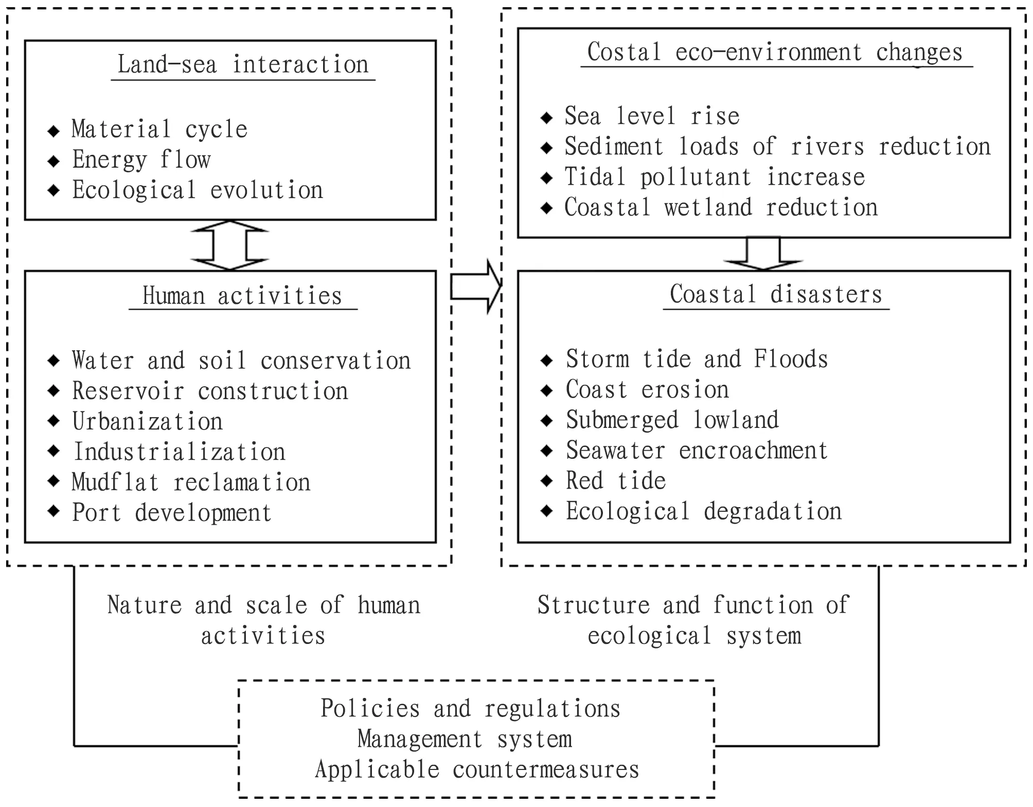
Fig.8 A system model of man-land relationship for problems of resource environmental during coastal development in China
4.1 Improving the management mechanism of coastal zone
The ecosystem-based marine space planning is a comprehensive, far-sighted, and integrated process of decision programming relying on oceans by humankind, and it is of important utility in promoting sustainable use of resources, optimizing maritime use, coordinating and solving the conflict of human use with natural environment and users. At present, departmental (industry-specific) scattered management is implemented in the management of coastal zones in China with administrative means applied in most cases. Hence, the current management mechanism needs to be reformed and completed to enhance such construction work as coordination and administration mechanism of maritime affairs between departments and between regions. Firstly, in the future, enforcement capacity building shall be enhanced on the basis of law to make up the vacancy of law system and coordinate the conflict between laws in every profession and trade. Secondly, coordination mechanism of sea-land integration and administration sections to guarantee effective implementation of sea-related policies and laws. Thirdly, public participation channel shall be expanded and public participation system shall be built to realize joint effects of plural subjects and to effectively improve comprehensive marine management.
4.2 Strengthening the integrated watershed managementFor a long time, we have put excessive emphasis on economic functions of the valleys, but ignored their ecological functions. On the one hand, hydraulic engineering building and water and soil conservation engineering building, such as reservoirs in middle and upper reaches of great rivers have rapidly reduced tidal sediment load, which has brought severe ecological impact to estuaries and coastal zones. On the other hand, unreasonable use of water resources caused by economic development has brought about river pollution and constant deterioration of overall water quality in the valley. Large quantity of pollutants has been taken into the sea, which is the main source of ocean pollution from land-based source. Therefore, "promoting comprehensive reclamation to river basin", and ensuring coordinated development of upper, middle and lower reaches and estuary areas is of great significance to solving such environmental problems as destruction of material balance in coastal zone caused by tidal sediment reduction, and degradation of sea water caused by large quantity of pollutants from land-based sources carried by tidal rivers. Measures suitable for lower reaches and estuary areas include: at the political level, influencing decision of the governments and administrative agencies in middle and upper reaches of the river basin, and at the economic level, providing financial and technology support for comprehensive reclamation of river basins.
4.3 Attaching importance to the environmental engineering construction of coastal zoneResource and environmental problems caused by global change (sea level rise) and human activities in coastal zone in China, not only intensify coastal disasters, such as storm tide, coastal erosion, sea water erosion, and flooding of low lying land, but also affect evolution of coastline and marine environment and development and utilization of various resources, and also cause great losses. The coastal areas should adopt resource and environmental engineering construction in the light of actual conditions to enhance anti-disaster ability, reinforce resource protection and pollution control and to improve ecological environment. Firstly, band protector of coastal zone and coastal flood dike construction shall be done to minimize the dangers of storm tide, typhoon, and flood as well as coastline erosion; secondly, shelter forest project for the coastal zone shall be carried out to resist destruction from typhoon and improve the ecological environment of offshores; thirdly, pollution control works in the coastal zone shall be carried out to decrease and control offshore pollution and to improve offshore water quality; fourthly, inter-basin water diversion project shall be carried out in case of such dangers as sea water erosion and land subsidence caused by over-extraction of groundwater.
4.4 Improving the environmental monitoring and assessment systemFor a long time, partitioning and monitoring parameters and indexes of ecological environmental monitoring network of China are not quite similar, which makes monitoring data far less than meeting the needs of the marine management on the basis of ecological system, hence, the current monitoring ability and environmental assessment must be increased. The surge of geographical information technology to obtain, analyze and adopt information provides a new tool for comprehensive management and resource development and utilization of coastline and oceans based on ecological system. On the one hand, national or regional marine monitoring system shall be established and information sharing platform shall be constructed. Environmental monitoring system integrating atmosphere, valley and oceans (coastal zone) as well as information database on the basis of 3S shall be built to realize resource sharing. On the other hand, marine ecological service value should be taken into full consideration and marine ecological environment quality shall be evaluated. On the basis of scientific assessment of environmental capacity, ecological system service and value thereafter,etc. of immediate offshore area, marine environmental effects shall be evaluated, and hierarchical system of environmental quality shall be divided to determine ecologically sensitive area, fragile area and ecological security threshold.
杂志排行
Asian Agricultural Research的其它文章
- Grafting Propagation Techniques of Red Sandalwood (Pterocarpus santalinus), a Precious Hongmu Tree Species
- Planning, Protection and Construction of Ancient Villages in Jiangxi under the Background of New Urbanization: Taking the Water Management System of Mingkou Village in Leping City, Jiangxi Province as an Example
- Application of Biogas in North China
- Analysis on Regional Development Model of Rural E-commerce
- Research on the Sustainable Development of Agriculture
- Countermeasures against Prominent Problems of Forestry in Yutian County under the New Normal
