Characteristics of helium accumulation in the Guanzhong Basin, China
2019-01-12MinDongZongxiuWangHuiDongLihengMaLinyanZhang
Min Dong , Zong-xiu Wang , Hui Dong , Li-heng Ma , Lin-yan Zhang
a Institute of Geomechanics, Chinese Academy of Geological Sciences, China Geological Survey, Ministry of Natural Resources, Beijing 100081, China
b Key Lab of Shale Oil and Gas Geological Survey, Chinese Academy of Geological Sciences, China Geological Survey, Ministry of Natural Resources, Beijing 100081, China
c Xi’an Center, China Geological Survey, Ministry of Natural Resources, Xi’an 710054, China
Keywords:
Guanzhong Basin
Fluid inclusions
Thermochronology
Helium reservoir accumulation
A B S T R A C T
Guanzhong Basin is located in the transitional zone between the Qinling orogenic belt and the Ordos plateau. Analyses of drill and geothermal wells depict that the Guanzhong Basin has abundant gas, and its major source rocks are the U-rich granites. In this study, the granitoid intrusive samples were collected from the Huashan, Baoji, Muhuguan rocks in Guanzhong Basin. A micro laser Raman spectrum examination was used to measure the composition of inclusion in the granite quartz fissures. The results depict that the inclusions include both gas-liquid and H2O-NaCl-CO2 inclusions and that their composition primarily includes H2O and CO2, with small amounts of CH4, H2 and H2S. These inclusions can be classified into nearly-primary, early secondary, and late secondary inclusions, which have homogenization temperatures of greater than 430 °C, 330-370 °C and 170-230 °C, respectively, based on the inclusion measurements. Additionally, the apatite fission-track investigations of six samples, which were collected from the granites at Huashan, Baoji rocks and the southern margin of Muhuguan along with the Cretaceous Sigou Formation sandstones that are located in the northwestern margin of the Guanzhong Basin reveal that the northern Guanzhong Basin began to receive deposits as early as 84-69 Ma. This period was accompanied by the rapid uplift of the Qinling orogenic belt, which was followed by an uplift of the southern basin margin and the Qinling orogenic belt from 44-28 Ma. The authors obtained an age histogram and a probability density distribution of three sample points. The results show that the age spectra of the zircons in the Cretaceous Sigou Formation sandstones can be divided into four tectonic events. Combined with the ages of apatite fission tracks and zircon, the Guanzhong Basin has experienced five tectonic stages as follows: 28-84 Ma, 170-260 Ma, 280-510 Ma, 610-1200 Ma, and 1210-2870 Ma.Using the thermal chronology constraints, inclusion composition analyses, which include the homogenization temperature measurements, and regional burial history, this paper conclude that the early secondary inclusions are primarily composed of CO2 and N2, whereas the late secondary inclusions are composed of CH4. Furthermore, this paper identify two periods of reservoir accumulation, out of which the later period is assumed to be the main accumulation period. Therefore, the period of the formation of the late secondary inclusion in the Guanzhong Basin and the Miocene era is observed to overlap with the main helium reservoir accumulation period.
1. Introduction
2. Geological background
Guanzhong Basin is also referred to as the Weihe Basin or Guanzhong Plain. Along with the Fenhe Basin, it forms the“Fen Wei Graben”, Guanzhong Basin is located to the north of the Qinling orogenic belt and to the south of the northern mountains of the Weihe, China. It is located in the southern margin of the Ordos Plateau and borders Yuncheng of Shanxi in the east and Baoji in the west (Wang B et al., 2013; Fig.1).Guanzhong Basin is a Cenozoic sedimentary basin, which spans 22000 km2with an asymmetric dustpan like structure extending East-West. It is observed to be wide to the east,narrow to the west, and its slopes are observed to be gentle and steep in the north and south, respectively. The acrossbasin structure is dominated by fault blocks, which are observed to originate from the south. However, the northern fault blocks are observed to be rare, relatively simple, and characterized by fault benches.

Fig. 1. Tectonic units and sampling points in the Guanzhong Basin, China.
Guanzhong Basin is controlled by four macromolecule structure systems, including the Qinling latitudinal structural system, Qilianshan-Luliang-Helanepsilon- type structural system, Neocathaysian structural system and Longxi rollup interest structural system. The latitudinal structure system of Qinling has experienced multiple-stage events since the Paleozoic and exhibits sings of present activity. The remaining three systems generally began to form in the early Mesozoic and are observed to be active today. The major part of the Guanzhong Basin is controlled by the east-west structure in the area. The east part of the basin contains traces of Neocathaysian structures, while the west constitutes the West Longxi rollup system, which is controlled by the Qilianshan-Lulian system that is located to the north and has an arc structure. The different combinations and directions of the Guanzhong Basin faults result in altering depocenters,stratigraphy, lithofacies, and structure line directions. The main sedimentary period gradually becomes younger as it moves from southwest to northeast. The depocenters are located to the south, deep south, and shallow the north with east-west echelon arrangements. The deep sags are located in the south basin and include Yuncheng sags, Gushi sags, and Xi’an sags (from east to west). Xi’an sags, Gushi sags, and Yuncheng sags have sedimentary thicknesses of approximately 7 km, 6.8 km, and 5 km, respectively.
The Guanzhong Basin encompasses thick Cenozoic dements and is covered by a quaternary system. The northern and southern parts of basin exhibit both lithological and sediment logical differences. The southern basin margin contains exposed Archean granite gneiss rocks and a Sinian period subkingdom shallow metamorphic rock system.Additionally, there are large pieces of the Yanshanian granite and a variety of dikes, which contain large amounts of orthoclase and granite talus. This depicts that the region was located near to formation of alluvial sediments. The Sinian subkingdom, which is characterized by high quartz, low talus,and high calcite contents, is exposed in the far eastern and western portions of the basin. These may be fluviolacustrine sediments, which contain extensive amounts of calcite and are likely to be formed from the precipitation of calcite rich late Paleozoic surface or groundwater, which dissolved carbonate rock from the northern mountainous region.
Helium has two isotopes,3He and4He, having atomic masses of 3 and 4, respectively. There are three sources of helium, which include atmospheric, crust-derived, and mantle-derived helium.3He is generated by theβ-decay of tritium and is primarily sourced from the mantle.4He is theαdecay product of radioactive elements, such as uranium and thorium, and is mainly derived from the crust (Bullentine CJ et al., 2002; Zheng Z and Ballentine CJ, 2006). Further, this paper observed that naturally occurring helium is primarily derived from the Earth’s crust. Helium that is separated from helium-rich natural gas has a4He/3He ratio of approximately 107:1, which indicates extremely low3He content. Scientists have explored lunar soils that are rich in3He, derived from solar wind, and formed by lunar soil adsorption to solar radiation particles.
According to helium isotope analyses of 64 natural gas samples (Xu YC et al., 1994; Du JG et al., 1998; Zhang X et al., 2015; Zhu DY et al., 2017), the3He/4He ratio ranges from 2.2×10⁻⁸-7.8×10⁻⁷with an average of 1.02×10⁻⁷. The majority of wells that contain helium contents between 0.1%and 1% are distributed along the faults that are observed in the Guanzhong Basin sag area. Additionally, they produce crustderived helium. Wells containing more than 1% helium are located near to the Qinling orogenic belt and are distributed in the southern basin margin. The areas having deep and large faults produce crust-derived helium, combined with small amounts of mantle-derived helium (Hilton DR et al., 1993;Wang Y et al., 2006; Li XC et al., 2016). Thus, the helium in the Guanzhong Basin natural gas samples is primarily observed to be crust-derived helium, with small amounts of incorporated mantle-derived helium.
On the basis of the crust-derived helium genesis in the Guanzhong Basin, this paper assumed that the granites in the peripheral and deep Guanzhong Basin may be the helium source rocks. The helium enrichment that is observed in Guanzhong Basin is closely related to uranium ore enrichment, as helium is intimately connected to radioactive uranium disintegration. The uranium-rich rock in Guanzhong Basin is observed to be predominantly belonging to the early Yanshanian, and the uranium enrichment period was observed to be from the late Yanshanian to the Himalayan. For the Lantian uranium ore field that is located in the northern Qinling orogenic belt, the field output is observed at the northwest end of the Yanshanian Muhuguan rock mass.Further, this paper observed that the northwest rock mass is underdevelopment and that the northern side encompasses,the north-east fracture of the northern Qinling orogenic belt and that the ore body is located in the wedge clamp area,which consists of two fracture belts. The uranium ore in the Guanzhong Basin is related to the Muhuguan rock masses and is the main granite disintegration rock. The field geological survey that this paper conducted in this study observed purple fluorites in areas of exposed Muhuguan rock mass, which is located in the Shangzhou district of Shangluo city, where the mountainous vegetation is not observed to be dense. The Muhuguan rock mass primarily consists of granodiorite,monzogranite, and biotite-rich mica granite. LA-ICP-MS zircon U-Pb analysis of the main lithology exhibits an emplacement time of 151±2 Ma for the Muhuguan rock mass(Ding LX et al., 2010). Further, this paper observe that the rock is a product of the late Jurassic to early Cretaceous magma activity that occurred in Yanshanian.
总之,昂昂溪文化作为我国境内原始文化的代表之一,其原始美术层面的发展成就是可圈可点的。对其所进行的研究方兴未艾,对此我们任重道远。
A comprehensive analysis was performed on the radioactive elements and the radioactive strength of the peripheral rock samples that were obtained from the Guanzhong Basin. The results depict high content of radioactive elements and radioactivity values in the Lantianmonz ogranite and granite rocks, along with the Muhuguan biotite monzogranite (Zhang X et al., 2015). Thus,the Lantian and Muhuguan rock masses in the southern Guanzhong Basin margin, having high uranium contents, are the main sources of crust-derived helium. Aeromagnetic and gravity measurement depict a number of concealed granite rock masses in Yanshanian (along the edge of Guanzhong Basin), which are observed to be similar to the Lantian and Muhuguan rock masses, and three large internal EW-NEE oriented fracture belts at depth. They are buried at a depth of 10-20 km and may be helium sources for the Guanzhong Basin.
3. Inclusion analyses
The Weishen-13 well in Guanzhong Basin depicts that the combustible natural gas contains helium in the Eocene rapidaccumulation clastic rock reservoir-layer that is located in the tertiary system of the Cenozoic. In the Hongxing chemical factory well, which was located three kilometers to the north of Fengxian county, the gas-layer is observed at 200 m the Paleozoic metamorphic carbonic schist of the Qinling orogenic belt sand contains 2.86% of helium.
These different reservoir layers exhibiting helium enrichment depict that genesis is that it is generated by the release of an α particle using heavy element (e.g., uranium,thorium, and samarium) radioactive fission.
3.1. Principle of the Raman spectrum
The Raman spectrum includes a light scattering phenomenon of molecules. Additionally, this paper observed that the Raman spectrum is a molecular vibration spectrum.The inelastic collision scattering spectrum is referred to as the Raman spectrum and was discovered by the Indian physicist C.V. Raman in 1928 while studying scattered light. A Raman spectrogram includes Raman displacement, Raman relative scattering intensity, and Raman spectrum peak form and envelope line. Due to the weak Raman scattering signal, all types of Raman spectrum signals that are obtained from the experiment must be used. Except for the Raman displacement and scattering intensity, no information, such as the Raman spectrum peak form half-width, and spectrum peak shoulder,can be ignored. The relation between the spectrum peak form and the molecular and crystal structures is observed to be very complicated and involves multiple factors, which require further investigation. Further, the Raman spectrum peak as symmetry depicts the existence of overlapping peaks. If asymmetry occurs to the right or left of a Raman spectrum peak, the original peak position and intensity must be rationally analyzed using a spectrum peak fitting and stripping software.
The general structure of the laser Raman spectrometer includes the laser light source, argon particle laser head, large sample room and microscopic table system, double monochromator, detector, spectral coupler, computer, and data processing system. Installation of a Raman spectrometer on the optical microscope system creates a laser Raman spectrometer, which can focus on a 1 μm2area to discern the molecular composition and area of various structures. As the laser Raman spectrum test performs a nondestructive test for a single inclusion, it is easy to distinguish between the primary as well as secondary inclusion compositions, which are located in the main mineral fissures. Additionally, we observe that it is easy to distinguish between false secondary and metagenetic inclusions using this technique in the case of single inclusion composition measurements. As Raman spectrum analysis provides a simple and reliable method of identifying inclusions containing organic and hydrocarbon inclusions, it is applied to geological research.
3.2. Inclusion composition and spectrum analyses
In this study, samples were collected from a granite quartz vein that is located in the southern margin of the Guanzhong Basin. This paper used the InVia-type Laser Raman Spectrometer (British Renishaw Company) to analyze the fluid inclusion compositions. However, this paper polished both the sides of the samples to manufacture 50-80 μm thick inclusion chips before performing Raman analysis. Further,this paper used a microscope to observe sample petrographic characteristics and quartz vein fissure development.
On the basis of detailed petro graphic observation and microscopic study, this paper carefully selected the inclusions that represented the characteristics, period, and oil-gas information to perform standardization. This paper described and measured the inclusion characteristics (e.g., distribution,form, size, color, and phase state). Additionally, this paper sketched and captured the photos of the inclusions under a microscope. Finally, the authors recorded the specific point location, phase state, purpose, and period of inclusions that was bombarded by the laser beam. The results of analyses of different phase state fluid inclusion compositions for ten typical inclusion samples of the granite quartz vein are depicted in Table 1.

Table 1. Gas-phase laser raman analysis and Homogenization temperature of the fluid inclusions of quartz vein in the Guanzhong Basin.
Fluid inclusions usually contain a variety of solid, liquid,and gas components. Further, the authors quantitatively analyzed a small part of the fluid inclusion composition using a Raman spectrometer because the standard Raman spectrum for all known material has not yet been established (Zhang Q et al., 2005). The authors determined other compositions using spectrum characteristic peaks. The results depict that H2O and CO2are the principal components of the liquid phase inclusions in the granite quartz vein, which is obtained from the southern margin of the Guanzhong Basin and that the H2O mole fraction is observed to be typically greater than 50%.CO2, CH4, and N2are the principal components of the gas phase inclusions, which further contain small amounts of H2S and H2. The gaseous phase inclusions can be classified into two phases as early secondary inclusions, which have CO2and N2as principal components, and late secondary inclusions, which contain CH4.
3.3. Inclusion homogenization temperatures
Fluid inclusions are observed to be multiphase and immiscible. Further, the authors observed that only the homogenous phase fluid inclusion homogenization temperature presents that inclusion formation temperature.Therefore, in this experiment, the authors initially selected the saltwater inclusions from the same period as the quartz vein fluid inclusions and conducted the homogenization temperature test. The authors used the THMS600-type Cooling-Heating Stage (British Linkam company) to measure the inclusion homogenization temperatures, as depicted in Table1.
Primary inclusions are randomly distributed and are observed to be 5 μm in size. Further, the primary inclusions mainly consist of CO2and are observed to have homogenization temperatures that are greater than 430 °C.The secondary inclusions, which include CO2, gas and gasliquid phase inclusions are observed to be 3-10 μm in size and directionally distributed. According to the period of formation, this paper divided the secondary inclusions into early and late secondary inclusions.
Further, the homogenization temperatures of the early and late secondary inclusions were observed to be 330-370 °C and 170-230 °C, respectively.
3.4. Using the burial history to determine the period and time of reservoir accumulation
To determine the filling time and reservoir accumulation of helium in the southern margin of the Guanzhong Basin,this paper conducted a petro graphic microscopic observation of the fluid inclusions in the quartz-vein granite pieces.Further, this paper performed an inclusion composition analysis using the laser Raman spectrum. This paper designated the homogenization temperature of saltwater inclusions that accompanied hydrocarbon inclusions (of similar time intervals) to be the minimum paleo temperature at the time of capture. Further, this paper combined this data with the paleo geothermal evolution history that is associated with the Weishen-10 well and indirectly determined the helium reservoir accumulation period of each phase by applying the fluid inclusion method. Initially, this paper identified the burial depth when the fluid inclusions in the quartz vein fissure were captured. The burial depth formula is observed to beH=(Tc-To)/G, whereHis the buried depth at the time of the reservoir accumulation (m),Tcis the fluid inclusion homogenization temperature,Tois the average surface temperature that is set to 17 °C (Xu BR, 1992; Zhang X et al., 2015),Gis the paleo geothermal surface temperature that is set to 3.5 °C/100 m. The Xi’an geothermal field in the Guanzhong Basin generally depicts a positive anomaly, where the gradient is observed to be 3.5-4.1 °C/100 m, with a maximum of 4.88 °C/100 m that is compared to the relatively shallow Moho surface depth of Guanzhong Basin (30-33 km)and the shallower curie surface depth (20 km) (Xue HF et al.,2004). The average geothermal gradient of the Guanzhong Basin is observed to be 3.0 °C/100 m, and the geothermal gradient is observed to decrease with increasing depth (Xu BR, 1992; Zhang X et al., 2015; Zhang XL et al., 2018).During the Cenozoic significant denudation occurred in the Guanhzong Basin, and the denudation thickness of the southern basin margin is combining the calibrated amount of denudation with the petrographic inclusion analyses, laser Raman spectrum tests, and microscopic measurement temperatures, we determined a homogenization temperature of 170-230 °C for the late secondary inclusions. Furthermore,the simulated and inferred inclusion depth at the time of capture was observed to be 1800-3500 m.
The fluid inclusions in the granite quartz vein fissure that was obtained from the southern margin of the Guanzhong Basin contained the history of helium filling and reservoir accumulation. The reconstruction of the burial and geothermal evolution history for Weishen-10 well established the relation between fluid inclusion homogenization temperature and the reservoir accumulation period. The late secondary inclusions are formed between 25-7 Ma, or N1-N2(Miocene-Pliocene).The formation time of the middle-late secondary inclusions in the granite quartz vein represents the time of helium filling and matches with the timing of basin subsidence. The increase in Sr isotope ratios in sea water during the early Miocene represents the strong uplift of rocks having high-radiation geneses in the Himalayan crystal belt, which caused radioactive enrichment during the burial period (Teng ZH et al., 1996).
4. Fission-track dating
This paper used the apatite fission-track test method (Ren ZL et al., 1995, 2007, Xing ZY et al., 2005, Xiao H et al.,2013) to analyze granites that were obtained from the southern margin of Huashan, Baoji, and Muhuguan, along with the sandstones from the Sigou Formation in the Guanzhong Basin. The sample collection points are observed to be significantly less than the sedimentary formation age,which indicates that all the samples were influenced by tectonic-thermal events that caused post formation annealing.Thex2test valueP(x2) of all single grain ages that were obtained from the fission-track analyses is observed to be greater than 5%, which signifies that the single grain age differences that is obtained from the sample average is considered to be a statistical error. Thus, the sample grain track ages belong to the same group, depicting that the samples underwent a single cooling process.
The measured fission-track length is observed to be less than that of the original track, indicating that the samples experienced strong annealing processes. As depicting in Fig. 2,the track length histogram generally depicts unimodal characteristics, depicting that the samples did not experience any complex thermal history and may have always been subjected to a dull cooling process.
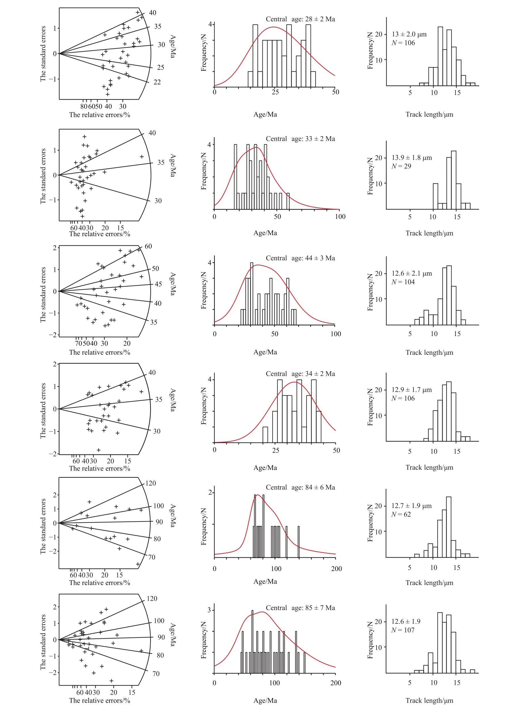
Fig. 2. Radial plots of the central age (left), c-axis projected confined fission-track length distributions (center), and the fission-track length distribution histogram (right) of selected samples in the Guanzhong Basin, China.
The apatite ages in the area range from 84-28 Ma, with sandstone and granite fission-track ages of 84-69 Ma and 44-28 Ma, respectively as depicted in Table 2. The Muhuguan rock mass primarily comprises granodiorite,monzogranite, and biotite-rich mica granite. Dating of the main lithology using LA-ICP-MS zircon U-Pb analyses illustrates an emplacement time of 151±2 Ma for the Muhuguan rock mass, and the measured age of the granite apatite is observed to be less than the granite formation age.Therefore, apatite fission-track information reflects the late tectonic thermal activity.

Table 2. Apatite fission-track results in the Guanzhong Basin.
According and accumulate deposits. Additionally, the Qinling orogenic belt was rapidly uplifted, keeping pace with the strong expansion and rifting in eastern China, along with the development of a sag basin. Due to the strong sag activities that were observed in the southern basin margin, the southern part of the basin contains higher sedimentary thickness than in the northern portion, which is consistent with the geological information and seismic profile obtained from the field geological survey. The Guanzhong Basin is an asymmetric dust pan-like basin, and seismic profiles depict that a series of skip-shaped sags were developed with fracture features in the south and southern part of the basin. The main sedimentary period of the Guanzhong Basin gradually becomes younger from south to north, and the depocenter is observed to be near the southern basin margin, which is observed to be deep in the south and shallow in the north.Guanzhong Basin and the Qinling orogenic belt essentially act as a single unit. During the significant sag and subsidence of the Guanzhong Basin, the Qinling orogenic belt was lifted,which indicated that the basin subsidence was closely related to the mountain uplift. An uplift mountain occurred again in the Qinling orogenic belt and the southern basin margin from 44-28 Ma. Apatite fission-track ages illustrate spatial distribution differences, depicting that the tectonic-thermal activities have differences, depicting that the tectonic-thermal activities have different evolutionary stages and that the record of rock cooling recorded the process changes. Under fission-track age constraints, Raman spectrum analyses of inclusions depict that the late fluid inclusions contain CH4.Thus, the tectonic-thermal activity of this period is important in understanding helium reservoir accumulation.
5. Test and zircon U-Pb dating
The Guanzhong Basin samples that were analyzed for zircon U-Pb were collected from Cretaceous Sigou Formation sandstones that were observed in the northwestern margin.Recently, numerous studies have focused on this area. As clastic sedimentary rocks contain source area information(Zhang X et al., 2017; Wang XY et al., 2018; Zhao LG et al.,2018), studying these rocks provides a new perspective to answer the helium accumulation questions in the Guanzhong Basin.
This paper used the LA-ICP-MS to analyze 180 (including 115 concordant points) zircon grain samples at the micro zone isotope geochemistry laboratory for geological mineralization and mine indication key laboratory of Ministry of Land and Resources. The distribution of all the concordant points on the206Pb/238U-207Pb/235U concordant diagram is depicted in Fig.3 (Dong M, 2018). This paper obtained an age histogram and a probability density distribution of these sample points. The age distribution of zircon U-Pb ages in the Cretaceous Sigou Formation sandstones can be divided into four time intervals of 170-260 Ma, 280-510 Ma, 610-1200 Ma, and 1210-2870 Ma. Through the data analysis of apatite fission tracks and zircon, the ages of tectonic events in Guanzhong Basin has been determined. The Himalayan tectonic events mainly occurred between 84 Ma and 28 Ma has been dominated by tectonic thermal events. Since the Yanshanian period, the Zircon ages range 2870 Ma to 170 Ma and mostly four time intervels. It shows the Guanzhong Basin has experienced multiple tectonic events.
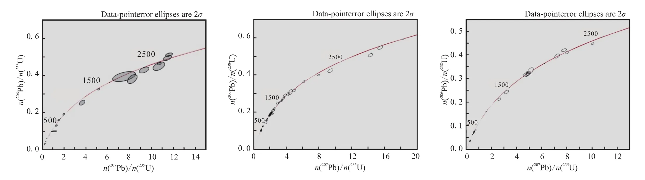
Fig. 3. The histogram of the detrital zircon U-Pb dating of selected samples in the Guanzhong Basin, China (after Dong M etal., 2018).
6. Conclusions
In addition to the conventional reservoir, roof, and trap conditions for natural gas, industrial helium reservoir accumulation in Guanzhong Basin was to the following three conditions. Initially, the granites in the southern Guanzhong Basin margin and the deep concealed rock granite masses developed, the basin is still an area of structural activity at present. Further, a large fracture developed, and the conditions were fixed for a carrier gas-reservoir, such as CH4.It is important to determine the period and time of the helium filling and hydrocarbon accumulation. This paper observe that fluid inclusions are an effective and extensively used method to determine reservoir accumulation. Therefore, this paper used the fluid inclusion composition to measure temperature and to discuss the Cenozoic tectonic-thermal evolution process and characteristics of helium reservoir accumulation in the study area on the basis of the Guanzhong Basin field geological survey, dating constraints, and apatite fission-track analyses.
(i) The granite quartz veins that were obtained from Huashan, Baoji, and Muhuguan contain large numbers of fluid inclusions. In the quartz fractures, laser Raman spectrum composition analysis of fluid inclusions illustrates the presence of primarily gas-liquid and H2O-NaCl-CO2inclusions, which can be divided into primary and secondary inclusions. Primary inclusions are mainly CO2inclusions having random distribution, which is observed to be 5 μm in size and having a homogenization temperature greater than 430 °C. The secondary inclusions are CO2and gas-liquid twophase inclusions with directional distributions and sizes of 3-10 μm. The secondary inclusions can be divided into early and late secondary inclusions, according to their formation periods. Further, the homogenization temperatures of the early and late secondary inclusions are observed to be 330-370 °C and 170-230 °C, respectively.
(ii) This paper conducted temperature measurements of fluid inclusions using the Raman spectrum. The samples in this area experienced complete annealing, all of the tracks were produced in cooling events. Thus, the apatite fissiontrack ages represent the different regions of the Guanzhong Basin depict variations in uplift and denudation. According to the fission-track records, the basin began to sag and accumulate deposits from 84-69 Ma, while the Qinling orogenic belt was rapidly uplifted from 44-28 Ma, an uplift occurred again in the southern margin of the Guanzhong Basin and Qinling orogenic belt. The age spectra of zircon UPb ages in the Cretaceous Sigou Formation sandstones can be divided into four tectonic events. Combined with the ages of apatite fission tracks and zircon, the Guanzhong Basin has experienced five tectonic stages as follows: 28-84 Ma,170-260 Ma, 280-510 Ma, 610-1200 Ma, and 1210-2870 Ma.
(iii) Under fission-track ages and the zircon U-Pb ages constraint, the authors utilized the results of laser Raman spectrum analysis. The early liquid inclusions are principally composed of H2O with small amounts of CO2, while the gaseous phase inclusions are composed of CO2, CH4, and N2,with small amounts of H2S and H2. The early secondary inclusions are dominated by CO2and N2, whereas the late secondary inclusions CH4. Therefore, the main period of helium accumulation since the Miocene occurred during the time of the late secondary inclusion formation in the Guanzhong Basin.
Acknowledgement
The authors thank the anonymous reviewers, who provided constructive comments and advice that greatly improved the manuscript. This study was supported by the Institute of Geomechanics in Chinese Academy of Geological Sciences (DZLXJK201608), the Geological Survey Project(DD20160183). This study was supported by the Key Lab of Shale Oil and Gas Geological of Chinese Academy of Geological Sciences, and the Key Laboratory for the Study of Focused Magmatism and Giant Ore Deposits.
猜你喜欢
杂志排行
China Geology的其它文章
- A sand-production control system for gas production from clayey silt hydrate reservoirs
- Characteristics and evaluation of Mesozoic source rocks in the southeastern East China Sea continental shelf
- Two types of uranium mineralization in Gulcheru quartzite: Fracture-controlled in Ambakapalle area and litho-controlled in Tummalapalle area, Cuddapah Basin, Andhra Pradesh, India
- Redefinition of Early Mesoproterozoic (1800-1600 Ma) stratigraphy in the northern Kongling area, China: The nucleus of Yangtze Craton and its tectonic significance
- Comparison of detrital mineral compositions between stream sediments of the Yangtze River (Changjiang) and the Yellow River (Huanghe) and their provenance implication
- Stretching correction for amplitude-preserving vector wavefield reverse-time migration