Identification Standard for ENSO Events and Its Application to Climate Monitoring and Prediction in China
2019-01-08HongLiRENBoLUJianghuaWANBenTIANandPeiqunZHANG
Hong-Li REN, Bo LU, Jianghua WAN, Ben TIAN, and Peiqun ZHANG
1 Laboratory for Climate Studies &China Meteorological Administration-Nanjing University Joint Laboratory for Climate Prediction Studies,National Climate Center, China Meteorological Administration, Beijing 100081
2 Department of Atmospheric Science, School of Environmental Studies, China University of Geoscience, Wuhan 430074
ABSTRACT The El Niño-Southern Oscillation (ENSO) reflects anomalous variations in the sea surface temperature (SST) and atmospheric circulation over the tropical central-eastern Pacific. It remarkably impacts on weather and climate worldwide, so monitoring and prediction of ENSO draw intensive research. However, there is not yet a unique standard internationally for identifying the timing, intensity, and type of ENSO events. The National Climate Center of China Meteorological Administration (NCC/CMA) has led the effort to establish a national identification standard of ENSO events, which was officially endorsed by the National Standardization Administration of China and implemented operationally in NCC/CMA in 2017. In this paper, two key aspects of this standard are introduced. First, the Niño3.4 SST anomaly index, which is well-recognized in the international ENSO research community and used operationally in the US, has replaced the previous Niño Z index and been used to identify the start, end, and peak times,and intensity of ENSO events. Second, two new indices—the eastern Pacific ENSO (EP) index and the central Pacific ENSO (CP) index, based on the SST conditions in Niño3 and Niño4 region respectively, are calculated to first determine the ENSO type before monitoring and assessing the impacts of ENSO on China’s climate. With this standard, all historical ENSO events since 1950 are consistently re-identified; their distinct properties are diagnosed and presented; and the impacts of ENSO events under different types on China’s climate are re-assessed. This standard is also employed to validate the intensity, grade, and type of the ENSO events predicted by the NCC/CMA operational ENSO prediction system. The new standard and the thus derived unified set of re-analyzed historical ENSO events and associated information provide a good reference for better monitoring and prediction of future ENSO events.
Key words: El Niño-Southern Oscillation, identification standard, monitoring, prediction
1. Introduction
The terms “El Niño” and “La Niña” originate from Spanish and mean “the little boy” and “the little girl, ” respectively. El Niño (La Niña) is associated with a band of warm (cold) water, occurring every few years over central to eastern equatorial Pacific. The recurrence of El Niño and La Niña events is the biggest fluctuation in the earth’s climate system and can not only affect the local climate near the eastern Pacific but also induce global climatic impacts via teleconnection (e.g., Bjerknes, 1969;Horel and Wallace, 1981; Rasmusson and Carpenter, 1982;Trenberth et al., 1998). For example, the super strong El Niño in 1997/98 and 2014-16 led to severe climatic disasters, including flooding in the Yangtze River basin(Huang et al., 2000; Zhang et al., 2016). Therefore, the monitoring and prediction of El Niño and La Niña events are extremely important.
Although much attention has been paid to El Niño and La Niña events, their identification methods differ in different countries (Wang, 1991; Trenberth, 1997; Guo et al., 1998; Li and Zhai, 2000; Trenberth and Stepaniak,2001; Hanley et al., 2003; Li et al., 2005), which may cause discrepancies. For example, the beginning and end of the 2014-16 El Niño event were not the same in China, the US, Australia, and Japan. After studying previous identification methods, the research team at the National Climate Center (NCC) of China Meteorological Administration (CMA) has formulated a standard for identification of ENSO events (Ren et al., 2017a). This new standard adopts the latest research results concerning ENSO events and helps improve the operational monitoring and prediction of these events. The standard was officially endorsed by the National Standardization Administration of China as GB/T 33666-2017 and implemented operationally in NCC/CMA in 2017.
Prior to that, the Niño Z index was used in operational monitoring of ENSO in NCC/CMA. It is defined as an area-weighted average of sea surface temperature (SST)over the Niño1+2, Niño3, and Niño4 regions (Li and Zhai, 2000). The advantage of this index is that the overall states of the tropical Pacific are reflected. A number of studies have pointed out the existence of different types of El Niño events due to varied zonal positions of the warming center (Fu and Fletcher, 1985; Ashok et al.,2007; Kao and Yu, 2009; Kug et al., 2009; Ren et al.,2013, 2016a). The climatic impacts induced by different types of El Niño events are very distinct (e.g., Weng et al., 2007; Zhang et al., 2011, 2012, 2016; Yuan and Yang, 2012; Yuan and Yan, 2013). But the Niño Z index cannot distinguish different types of El Niño, which limits its capability for El Niño monitoring.
Given the limitation of the Niño Z index, the new national standard (GB/T 33666-2017) uses the Niño3.4 index to describe the beginning, end, and amplitude of El Niño/La Niña events. In addition, it adopts the eastern Pacific (EP) and central Pacific (CP) type ENSO indices to verify the types of ENSO events (Ren and Jin, 2011,2013). This paper intends to describe the rational, methods, and results associated with establishment of the new ENSO identification standard in NCC/CMA. We begin(in Section 2) by describing the details of the standard for identification of ENSO events. Then, in Section 3, the characteristics of historical ENSO events are summarized by using this national standard. The use of the national standard in ENSO prediction is discussed in Section 4. In Section 5, impacts of different types of ENSO events on China’s climate are investigated. Finally, a summary and discussion are provided in Section 6.
2. Identification standard for ENSO events
2.1 Data and index definition
We use the Hadley Centre Sea Ice and Sea Surface Temperature dataset (HadISST) to calculate the SST anomaly during the period 1950-81 (Rayner et al., 2003),and the Optimum Interpolation SST dataset, version 2(OISSTv2) (Reynolds et al., 2002), with a 0.25° resolution, provided by the Climate Prediction Center (CPC) of NOAA from 1982 to 2017. Monthly 2-m temperature and precipitation data from 160 standard meteorological stations in China, collected since 1951, were obtained from NCC/CMA.
The study domain includes the Niño1+2 sector(10°S-0°, 90°-80°W), the Niño3 sector (5°S-5°N, 150°-90°W), the Niño4 sector (5°S-5°N, 160°E-150°W), and the Niño3.4 sector (5°S-5°N, 170°-120°W).
Observationally, the Niño3 and Niño4 SST indices are highly correlated. Two independent indices from Ren and Jin (2011)—the piecewise linear combination of the Niño3 and Niño4 indices conditioned by the ENSO phase—are used here to describe the EP-type and CP-type of ENSO events.
The EP-type ENSO index,NEP, is defined as

The parameterαis determined by a minimization procedure to produce two independent indices out of the Niño3 and Niño4 indices. To make the national standard easy to use, here, a fixed value of 0.4 is applied. The running correlation between the CP and EP El Niño indices is much weaker than that between the Niño3 and Niño4 indices for any given period (figure omitted), implying that the fixed value of 0.4 forαis robust.
All the Niño indices are calculated with respect to a 30-yr running average climatology (see footnote in Table 2). Though a fixed climatology is reasonable for research purposes, a changing climatology is more suitable for operational monitoring, because the dataset is constantly updated and previously defined events cannot be revised even if the climatology changes in the future. A changing climatology is hence recommended by the World Meteorological Organization (WMO) and adopted by CPC/NOAA and Japan Meteorological Agency(JMA) in ENSO operational monitoring.
2.2 Identification method
2.2.1Event definition
An ENSO event can be identified if the absolute value of the 3-month running mean Niño3.4 index (to one decimal point) reaches or exceeds 0.5°C and lasts for at least 5 months (El Niño event if the Niño3.4 index0.5°C; La Niña event if the Niño3.4 index-0.5°C). We use the Niño3.4 index instead of the Niño3 index used by the JMA, because the Niño3.4 index measures a part of both the Niño3 sector and the Niño4 sector, meaning that it can be used to capture the general features of ENSO.
2.2.2Event duration
The start month is defined as the earliest month during which the Niño3.4 index meets the criterion of an ENSO event. The end month is defined as the latest month when the Niño3.4 index meets the criterion of an ENSO event. The duration of an event is the number of months from the start month to the end month.
2.2.3Event strength
The event peak includes the peak time and the peak value, and can be defined as when the absolute value of the 3-month running mean Niño3.4 index reaches its maximum during the event. If there is more than one peak with the same value, the first one is chosen as the event peak.
The event strength is defined by the peak value of the event. The strength grade (intensity rank) of an ENSO event is identified as weak if the absolute value of the event peak is0.5°C but < 1.3°C; a medium event has an event peak between 1.3 and 2.0°C; a strong event has an event peak between 2.0 and 2.5°C; and a super strong event has an event peak > 2.5°C.
Note that the criteria of 1.3, 2.0, and 2.5°C are approximately 1.5, 2.5, and 3 times the standard deviation of the Niño3.4 index, respectively.
2.2.4Event type
An EP-type event is identified if the absolute value of the NEPindex is ≥ 0.5 and lasts for at least 3 months. A CP-type event is identified if the absolute value of the NCPindex is ≥ 0.5 and lasts for at least 3 months.
If both of the above conditions are satisfied in one event with a transition between the two types, the type when the event reaches its peak time is considered to be the primary type and the other one is the secondary type.Such a primary type is used as the type for the entire ENSO event.
2.3 Comparison with the standards of other operational centers
The CMA national standard for identification of ENSO events is compared with the operational standards used in other countries such the US, Australia, and Japan(Table 1). It is seen that JMA uses the Niño3 index and Australian Bureau of Meteorology (BoM) uses the Southern Oscillation index (SOI) to define ENSO events,while both CPC/NOAA and NCC/CMA use the Niño3.4 index. It should be noted that only the NCC/CMA standard adopts additional type identification for EP- or CP-type ENSO events to obtain more accurate climate impact assessment.
3. Re-identification of historical ENSO events
We re-compile the basic information of all the El Niño/La Niña events since 1950 according to the ENSO identification standard of NCC/CMA (Table 2). Furthermore, all the ENSO events identified by the national meteorological operation centers of the US, Australia, and Japan are also listed in Table 3, in comaprison with those identified by China. The performances of different ENSO identification standards are mostly similar, but with quite some discrepancies, in terms of event number, occurrence time, duration, and so on, for both El Niño/La Niña events. It should be noted that the difference between the events defined by China and the US results from different SST datasets used by the two countries.CPC/NOAA utilizes ERSSTv5 (Extended Reconstructed SST, version 5) data (Huang et al., 2017), while NCC/CMA uses HadISST (Titchner and Rayner, 2014) during 1950-81 and OISSTv2 after 1982 (Reynolds et al.,2002).
As shown in Table 2, there are 19 El Niño events and 14 La Niña events since 1950, including 13 EP El Niños,6 CP El Niños, 10 EP La Niñas, and 4 CP La Niñas.Most of the events identified here are quite consistent with those found in previous studies (Kao and Yu, 2009;Kug et al., 2009; McPhaden et al., 2011; Zhang et al.,2015). Notably, a few so-called mixed-type events found in the record have been mandatorily determined as either EP- or CP-type events in view of the China national standard, such as the 2016/17 event. To further examine the variations of ENSO phases based on these events,Table 4 shows the transitions of the ENSO events. Most of the EP El Niño events develop into EP La Niña events or a neutral state, while most of the EP La Niña events develop into EP El Niño events within two years. The de-velopment of CP El Niño/La Niña events is rather uncertain, which may cause difficulties for the prediction of ENSO type.

Table 1. Identification standards for ENSO events used by different meteorological operation centers (countries)
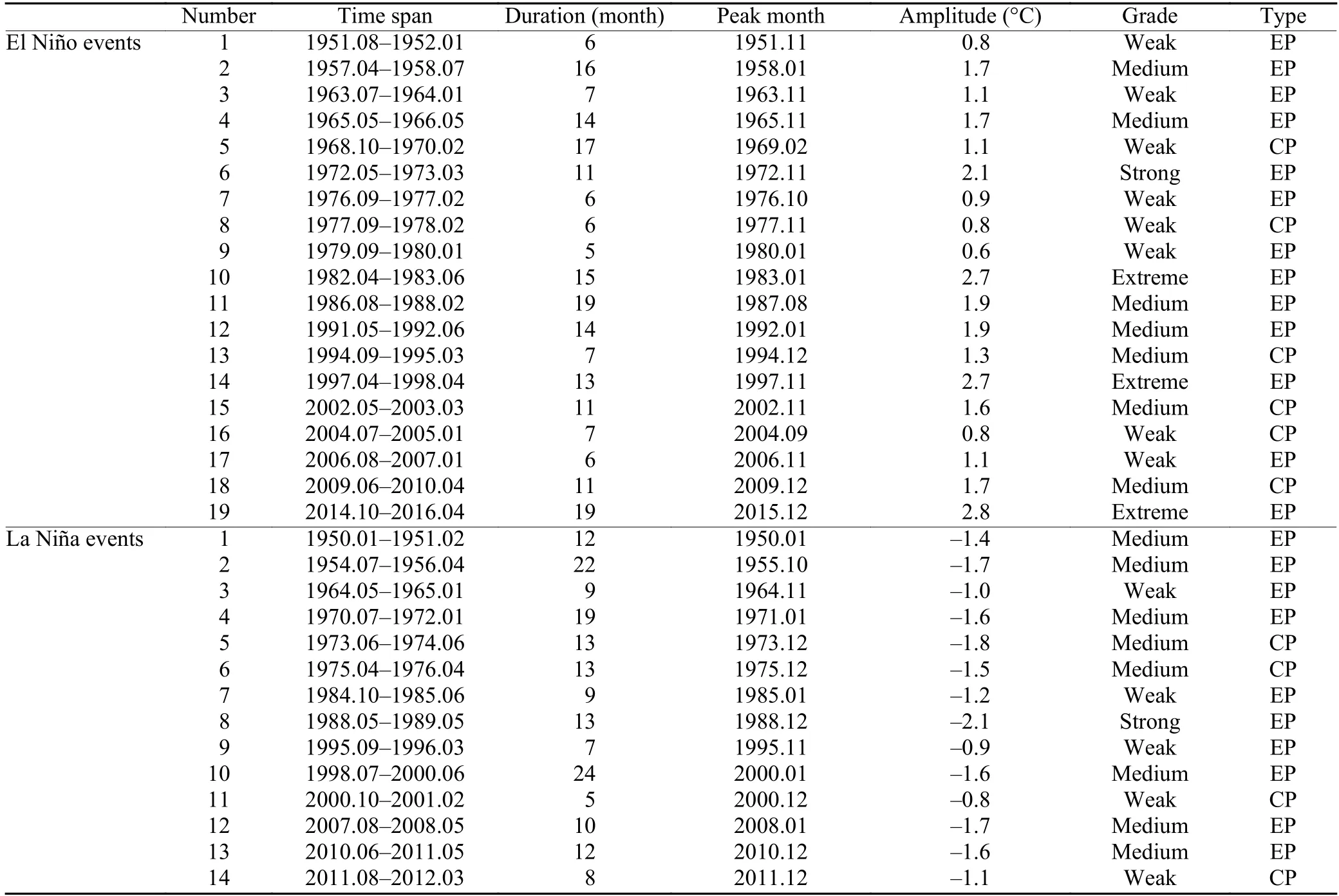
Table 2. El Niño and La Niña events since the 1950s, as identified by the NCC/CMA standard
The three strongest El Niño events are 1982/83,1997/98, and 2014-16, which are super strong El Niño events because their peak strength exceeds 2.5°C in all three cases (Fig. 1). The La Niña events are relatively weak, with no super strong events since 1950. Figure 2 exhibits the life cycle of different types of El Niño events. The EP El Niño events are generally stronger than the CP El Niño events. Figure 3 exhibits the temporal evolution of different types of La Niña events. The EP- and CP-type La Niña events are similar in their evolutionary features and strengths. With regard to the duration of El Niño events, as shown in Fig. 4, the two EP-type El Niño events of 1986-88 and 2014-16 have the longest life span, lasting for 19 months (Table 2), while the longest CP El Niño event occurs during 1968-80,lasting for 17 months (Table 2). Overall, La Niña events have a relatively longer lifetime compared to El Niño events, and the EP-type events are evidently longer than the CP type, with an earlier start month and later end month. Figure 5 further illustrates the probability density function of the Niño3.4 index and shows a strong asymmetry between the El Niño and La Niña phases, with a greater number of strong El Niño events. For the strong and super strong events especially, there are notably fewer La Niña events than El Niño events.
4. Application of the China standard
Based on the above-mentioned standard, 20-yr ENSO hindcasts with a multi-method ensemble (MME) provided by the NCC’s System of ENSO Monitoring, Analysis, and Prediction (SEMAP 2.0; Ren et al., 2016b,2017b) are used here to evaluate the accuracy in predicting the strength grades and types of ENSO events (Table 5). It can be seen that the SEMAP 2.0 MME can predict approximately 80% of the El Niño/La Niña events begin-ning from July; meanwhile, the system can also successfully distinguish the types of most El Niño events, which provides a very good background for the forecasting of the location of summer rainfall belt in China. It is clear that the SEMAP 2.0 prediction of ENSO amplitude is generally one grade weaker than observed. This may be related to the use of MME mean forecasting in SEMAP 2.0. How to further correct the predicted strength of ENSO within the SEMAP 2.0 system needs to be addressed in future work.

Table 3. El Niño and La Niña events identified by different meteorological operation centers

Table 4. Number of transition between different types of El Niño and La Niña events from 1950 to 2016

Fig. 1. Distribution of all ENSO events since 1950. Black curves represent the Niño3.4 index (based on a moving climatology). The red and blue filled areas represent the El Niño and La Niña events, respectively. The black vertical line indicates the peak month of the event.
The new ENSO standard was also employed to assess the performance of the ENSO hindcasts. An example of the predictions beginning from July in each year is shown here. As indicated in Fig. 6, for the El Niño events that have occurred since 1996, the Niño3.4 index predicted by SEMAP 2.0 can represent the observed peak strength well, and the correlation coefficient between the predicted and the observed peak strength is as high as 0.96. However, the correlation coefficient itself does not fully reflect the prediction bias of the ENSO intensity level. Instead, the new ENSO standard can be used to visually reflect this information. According to the standard for classification of different grades of ENSO events,the 2-D value domain in Fig. 6 is divided into several boxes. The boxes on the diagonals indicate that the predicted ENSO event grade is perfectly consistent with the actual observation level. We can see that, out of the 11 incidents, only 2 events fall into the diagonal boxes. As shown in Fig. 7a, SEMAP 2.0 tends to underestimate the intensity of both El Niño and La Niña events. Specifically, with the exception of the weak El Niño event in 2004/05 and the medium La Niña event in 2010/11, the predicted grades of all other ENSO events tend to be one level lower than the actual level (Fig. 7b). Therefore,ENSO predictions by SEMAP2.0 are generally weaker than observed.
The new ENSO standard can also be applied to evaluating the predicted ENSO type in addition to its strength.As shown in Fig. 8, the type predictions of 8 events out of the 11 ENSO events since 1996 are generally correct(the percentage is 73%). Of these, 4 out of 6 El Niño events are accurate, but the 2006/07 EP El Niño event is misrepresented as a CP El Niño event. For 2009/10, the CP El Niño event is misreported as an EP event. Four out of five La Niña events are accurate, and only the 2000/01 CP La Niña event is misrepresented as an EP La Niña event. Overall, the SEMAP2.0 MME performs reasonably well for predicting ENSO intensity grades and types. Indeed, the difficulty in distinguishing the two types of ENSO, even at a short lead time, is considerable(Ren et al., 2018a). The skillful forecast in the current case of SEMAP2.0 indicates a substantial positive contribution from the multi-method ensemble of the dynamical model prediction and its empirical error correction(Liu and Ren, 2017), as well as the physics-based statistical prediction (Ren et al., 2018b). This is a promising topic in need of further examination.
5. Revisiting the impacts of different types of ENSO events on China’s climate
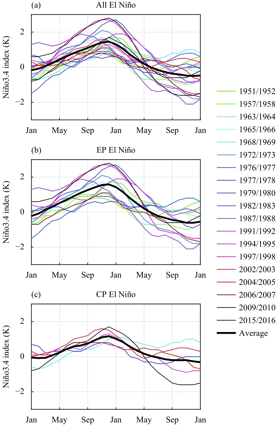
Fig. 2. Evolutions of the Niño3.4 index for El Niño events since 1950: (a) all El Niño events, (b) EP El Niño events, and (c) CP El Niño events.
As Fig. 8 shows, if we can make a more accurate judgment on the ENSO event type, important indications will be derived concerning regional climate (temperature and precipitation) predictions in China. As for ENSO’s impacts on China’s climate, many studies have been conducted and evident differences have been found existing between the impacts of the two types of events (Weng et al., 2007; Feng et al., 2010; Feng and Li, 2011; Zhang et al., 2011, 2012; Yuan and Yang, 2012; Yuan and Yan,2013). However, the conclusions in these studies regarding the impacts of the two ENSO types have not yet been systematically reviewed. Here, we use the information on the ENSO events shown in Figs. 2, 3 to comprehensively demonstrate significant differences in the impacts of the different types of ENSO events on precipitation and air temperature in China in the summers of ENSO development, the winters of ENSO peaks, and the following summers of ENSO decay (Figs. 9, 10). Here, the climatology of temperature and precipitation is defined by using all the data, and the linear trend is removed.

Fig. 3. Evolutions of the Niño3.4 index for La Niña events since 1950: (a) all La Niña events, (b) EP La Niña events, and (c) CP La Niña events.
Figure 9 shows the composite maps of precipitation anomalies in summer and winter in China based on all and different types of ENSO events. For the summers of the El Niño developing years, the precipitation in North China and the south part of northeastern China during the EP El Niño events is significantly low; the locations where rainfall is relatively less abundant can also be detected corresponding to the CP type events, which primarily occur southward in the lower reaches of the Yellow River and the upper-to-middle reaches of the Yangtze River. Meanwhile, precipitation in most of northeastern China is much less abundant compared to southern China. During summer (JJA1) of the decaying phase of EP-type El Niño, positive anomalies appear in northern China as well as south of the Yangtze River;whereas in the same stage for CP-type El Niño, increased precipitation is mainly located in the Yellow-Huaihe River valley and negative anomalies are present to the south of the Yangtze River, consistent with previous studies (Feng et al., 2010; Yuan et al., 2012). Furthermore, significant positive rainfall anomalies are observed in South China for EP-type El Niño during its mature phase (DJF0), as also demonstrated in some previous works (Feng et al., 2010; Yuan and Yang, 2012).Meanwhile, several inconsistent features of precipitation exist, relating to CP-type El Niño. Our study shows that,during the mature phase of CP-type El Niño, positive rainfall anomalies are significant over Southeast China,which is usually absent in other studies (Feng et al.,2010; Yuan and Yang, 2012). Several factors may lead to the differences with regard to this point. Firstly, some previous studies focused on a different and often shorter research period, thus adopting different ENSO events(even in the same period). Specifically, the event in 2009, which is a strong CP-type El Niño and generally absent in previous research, has been shown to seriously influence summer rainfall in Southeast China (Wang et al., 2012). Furthermore, most previous studies utilized the Niño3 and El Niño Modoki indices to compare the potential effects of the two types of ENSO, so varied definitions of ENSO types may also explain how these differences arise. Also, the precipitation from station rainfall data used here could differ from that obtained from some of the analysis data employed in other works,which may also make a difference to these results.
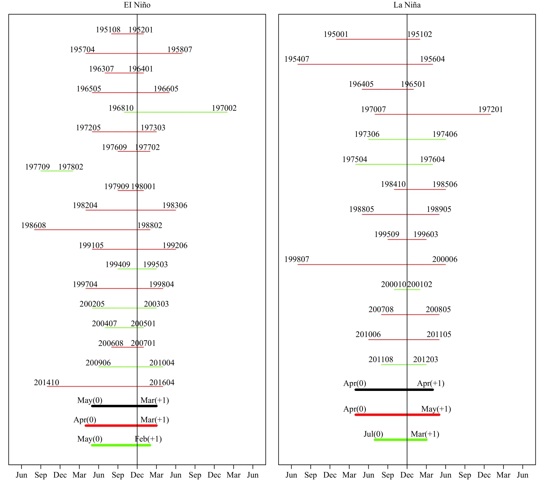
Fig. 4. Timespan of all EP (red) and CP (green) ENSO events. The three thick lines at the bottom are the averages of all events (black), EP events (red), and CP events (green). The left-hand panel is under the El Niño condition, and the right-hand panel is under the La Niña condition.
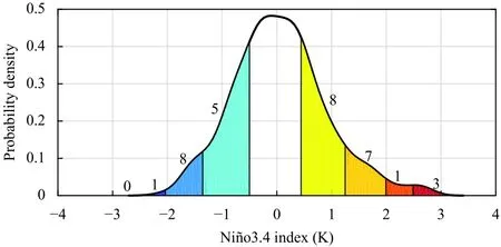
Fig. 5. Probability density function of the Niño3.4 index. The intervals are -2.5, -2.0, -1.3, -0.5, 0.5, 1.3, 2.0, and 2.5 K. The numbers indicate the number of events within each grade.
For the La Niña events, the differences between the two types of events are generally obvious in the three typical seasons. The differences in the summers of ENSO development are primarily in southwestern China,western Inner Mongolia, and so on, where an EP-type La Niña event corresponds to relatively humid conditions,while significantly less precipitation takes place duringCP-type events. In the winters of the two types of La Niña events, more precipitation appears in central China,and the difference lies in the obvious drought in the lower reaches of the Yangtze River corresponding to EP La Niña events. For the summers of the ENSO decaying years, larger deviations are found in central-eastern China, South China, Northeast China, and especially,South-central China. The EP La Niña events correspond to a “wet north-dry south” distribution, while the precipitation pattern during CP La Niña is nearly opposite.

Table 5. El Niño/La Niña predictions by the NCC SEMAP2.0 from 1996 to 2016. OBS and PRED indicate observations and predictions made from July of each year, respectively. The ENSO intensity grades SS, S, M, W, and N are abbreviations for super strong, strong, medium, weak,and neutral events, respectively

Fig. 6. Scatterplot of the ENSO intensities between the observations(x-axis) and the predictions (y-axis) made from July of the ENSO developing year. Colors are used according to the ENSO intensity, where gray, yellow, orange, and red indicate values < 0.5, < 1.3, < 2.5, and> 2.5, respectively. The correlation coefficient between the predictions and the observations is 0.96.
Figure 10 further shows the distributions of air temperature anomalies in China for the two types of ENSO events. In the summers of the El Niño developing years,the 2-m temperature characteristics during the EP El Niño events and all El Niño events are more consistent,showing low temperatures over the whole of China, as compared to the CP events, in which high temperatures across the northern part of the country form in significant contrast.
In the summers of the developing years for both types of La Niña events, northeastern China is notably warmer,especially so during CP El Niño events; and in the following winters of the CP warm events, the warm pattern remains while low temperatures mostly dominate across the whole of China corresponding to CP La Niña events,which are most significant in South China. In addition,note that, during the summers when the La Niña events decay, despite the fact that most of the central-southern parts of China tend to be cold, the colder areas during the CP La Niña events are close to the coastal areas and tend to move southward.
The above-mentioned results suggest significant differences exist between the influences of the two types of ENSO events on precipitation and temperature anomalies in China. Therefore, when considering the impacts of ENSO on climate anomalies, it is fairly necessary to further classify the types of events to obtain effective signals to predict climate anomalies in China.
6. Summary and discussion
The monitoring and prediction of El Niño/La Niña events are important topics in global climate studies.Even though great improvements have been achieved toward understanding El Niño/La Niña events, there is no unique method/standard to identify the start time, end time, duration, intensity grade, and type of these events.As a consequence, the operational monitoring of ENSO events often differs across institutions and countries. Recently, the research team in NCC/CMA formulated the national standard for the identification of El Niño/La Niña events (GB/T 33666-2017), which was officially endorsed by the National Standardization Administration of China in March 2017 and operationally implemented in NCC/CMA at the end of that year.
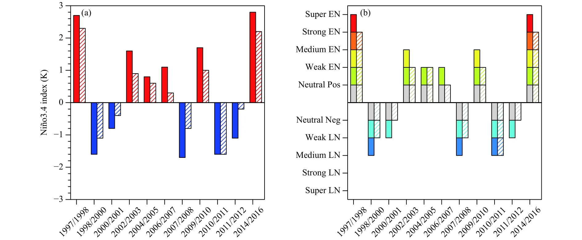
Fig. 7. ENSO (a) intensity and (b) grade from the observations (shaded bars) and the predictions (striped bars) of SEMAP2.0.
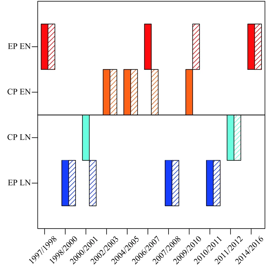
Fig. 8. ENSO types based on observations (shaded bars) and SEMAP2.0 predictions (striped bars). The shaded (striped) bars in red and orange represent EP El Niño and CP El Niño events, respectively,while the shaded (striped) bars in blue and green indicate EP La Niña and CP La Niña events, respectively.
In this paper, this national standard is introduced in detail and applied to climate monitoring and prediction.In this standard, the Niño3.4 index is used to describe the properties of the start time, end time, duration, and intensity of El Niño/La Niña events. Given that the Niño3.4 region is a key dynamical region for El Niño/La Niña dynamics, the Niño3.4 index is also widely used by international communications. In addition, the new national standard adopts two further Niño indices to quantitatively verify the types of El Niño/La Niña events,which is a distinguishing feature of this identification method. In light of the various impacts of the different types of El Niño/La Niña events on the climate over China, the identification of EP- and CP-type El Niño/La Niña events could improve the operational capability of ENSO monitoring.
According to this national standard, the characteristics of historical El Niño/La Niña events are comprehensively re-investigated, including the start time, end time,duration, intensity grade, and type of these events. As an application of this national standard, the operational prediction ability of El Niño/La Niña events by the NCC/CMA ENSO prediction system SEMAP2.0 is also assessed, by using the information on these events. It is demonstrated that most of the occurrences of El Niño/La Niña events can be predicted well at a six-month lead,even though the event amplitude is often underestimated with a relatively lower grade of intensity. The type of El Niño/La Niña event is also captured, at an accuracy rate of 73%. Overall, the ENSO prediction system of the NCC/CMA is capable of successfully predicting the key characteristics (intensity grade and classification) of El Niño/La Niña events.
As a recommended standard, it provides a reliable identification method for operational El Niño/La Niña monitoring. Our paper demonstrates, via a summary of historical events, an evaluation of operational predictions, and an assessment of different climatic impacts,that this national standard is a capable one. Particularly,the impacts of the ENSO events under different types on the precipitation and air temperature in China are revisited, and some new conclusions have been obtained. This new national standard will help improve our understanding and ability to predict El Niño/La Niña in terms of their different intensity grades and types.

Fig. 9. Composites of precipitation for all ENSO events and the two types of ENSO events. The six rows from top to bottom represent the composites of all El Niño, EP El Niño, CP El Niño, all La Niña, EP La Niña, and CP La Niña events, respectively. The three columns correspond to the boreal summer (JJA0) and winter (DJF0) in the ENSO developing year, and the summer (JJA1) in the ENSO decaying year. The yellow dotted areas are statistically significant at the 90% confidence level.

Fig. 10. As in Fig. 9, but for the composites of 2-m temperature.
杂志排行
Journal of Meteorological Research的其它文章
- The CAMS Climate System Model and a Basic Evaluation of Its Climatology and Climate Variability Simulation
- An Assessment of CAMS-CSM in Simulating Land-Atmosphere Heat and Water Exchanges
- Arctic Climate Changes Based on Historical Simulations (1900-2013) with the CAMS-CSM
- Impacts of Land-Use Data on the Simulation of Surface Air Temperature in Northwest China
- Modeling Study of Foehn Wind Events in Antarctic Peninsula with WRF Forced by CCSM
- Construction and Application of a Climate Risk Index for China
