Spatiotemporal change of carbon storage in the Loess Plateau of northern Shaanxi, based on the InVEST Model
2018-07-04ShaoYangLiuNingKeHuJinZhangZhiChaoLv
ShaoYang Liu, NingKe Hu , Jin Zhang, ZhiChao Lv
School of Geography and Tourism, Shaanxi Normal University, Xi'an, Shaanxi 710062, China
1 Introduction
Carbon is the main material element of contact and exchange of the biological and nonbiological, so maintaining carbon balance and stability is of great importance to the coevolution of the biological sector and the environment (Wanget al., 2009; Gao, 2014).In recent years, human activities have had a significant impact on the global carbon cycle and carbon dioxide concentration in the atmosphere and subsequently caused a series of environmental problems,such as global warming. Many scholars who are very concerned about changes in the terrestrial ecosystem carbon are studying carbon storage and distribution of the difference to solve ecological problems caused by human activities (Wanget al., 2014). To deal with the problem of soil erosion, the Chinese government adopted some policies in the 1950s regarding soil and water conservation on the Loess Plateau, an ecologically fragile region, and also launched a series of ecological construction projects in 1999, such as reforestation. These projects have played very positive roles in improving the regional ecological environment:regulating climate, reducing drought and waterlogging, and increasing carbon storage (Mu, 2002; Wanget al., 2005). Due to the implementation of the ecological construction project, there were some profound changes in the type and distribution of land use and cover on the Loess Plateau. Monitoring and evaluating carbon storage and density are necessary for com-prehensive analysis of the ecosystem-service function of the Loess Plateau (Liu and Lei, 2005; Gao, 2014).
Many typical models have been used to research carbon storage in recent years, such as the VAR (vector autoregression) model (Wuet al., 2015), the HASM (high accuracy surface modeling) model(Zhaoet al., 2014), and the InVEST (integrated valuation ecosystem services and tradeoffs) model (Zhanget al., 2016; Lianget al., 2017). Of these, the In-VEST model is widely used because of its simple parameter input (Bao, 2015; Tanget al., 2015). In-VEST overcomes the limitations of traditional evaluation methods, benefiting from its distributed algorithm based on 3S technology (GPS, RS and GIS technology). It is a new technology of space expression, dynamic analysis, and quantitative assessment of the ecosystem-service function. Based on different scenarios, this model can well evaluate the function and value of ecosystem service (such as carbon storage, soil and water conservation, and biodiversity)and balance regional economic development and protection of natural resources. It provides effective basic guidelines to formulation of the relevant policies(Huang, 2015; He and Sun, 2016). The InVEST model has been widely used in Minnesota and Hawaii in the United States, the Amazon Basin in South America, Indonesia, Tanzania, and other regions (Huanget al., 2013; Wuet al., 2013). Nelson used the InVEST model to quantify water production, carbon storage,and soil conservation of the Willamette River Basin in North America (Nelsonet al., 2009). Goldstein used the water-purification, carbon-storage, and timber-production modules of the InVEST model to evaluate Hawaii's forest ecosystem under different scenarios(Goldsteinet al., 2012). The research of domestic scholars using the InVEST model to evaluate each function of ecosystem services has increased during recent years. He and Sun combined remote sensing and the InVEST model to propose a new method of forest carbon-storage dynamic monitoring (He and Sun, 2016). Delphin used the InVEST model to evaluate changes of the ecosystem-service function under the influence of human activities, typhoons, and earthquakes in central Taiwan (Delphinet al., 2016). He and Zhang integrated the InVEST model and the LUSD-urban (land use scenario dynamics-urban)model to study the effect of urban expansion on regional carbon storage in Beijing (Heet al., 2016).Overall, many studies used the InVEST model to calculate carbon storage. However, few studies explored the relationship between land use types and carbon storage; and the scale of the study was much more dependent on administrative blocks rather than natural geographic blocks.
This study used land-use data from remote-sensing images and the carbon-storage module of the In-VEST model to research land-use and -cover change(LUCC) and spatiotemporal change of carbon storage on the Loess Plateau of northern Shaanxi over 15 recent years at the scale of county and subbasin.This study provides basic guidance on making a comprehensive evaluation of the ecosystem-service function of the Loess Plateau and regional ecological management.
2 Data and methodology
2.1 Study area
The study area is located on the Loess Plateau in northern Shaanxi Province (Figure 1). The shape of the region is narrow from north to south. In the northwest, there is the sandy area of North Yulin between the study area and the Inner Mongolia Erdos Plateau.The south is bordered by the Guanzhong Plain. The Yellow River lies between Shanxi and study area in the east. The western part is connected with the Loess Plateau of Longdong in Gansu Province. In the study area, there are twelve counties in Yulin and thirteen countries in Yan'an, a total area of about 79,981.9 square kilometers, accounting for 12.6% of the Loess Plateau and 38.9% of Shaanxi Province. This region spans from a warm temperate, continental monsoon,semi-humid climate to a temperate, semi-arid climate-transition zone, with an average temperature of 8 °C to 12 °C and an average precipitation of 350 mm to 600 mm (Songet al., 2009).
Due to loose soil and lack of vegetation, the Loess Plateau has a serious problem with soil erosion. Over the past century, to improve the ecological structure,the Chinese government has implemented a series of measures for soil and water conservation, which significantly improved the ecological condition of the Loess Plateau, including effectively curbing soil erosion and land desertification, greatly increasing vegetation coverage and regional hydrology, and greatly changing climate and land use and land cover (LULC)(Xi, 2006; Liu, 2009; Wang, 2010). These effects caused changes in carbon storage and distribution.
2.2 Data sources
The data used in this study included (1) data on land-use types in the Loess Plateau of northern Shaanxi in 1995, 2000, 2005, and 2010 (with a spatial resolution of 1,000m×1,000m; obtained by the Institute of Geographic Sciences and Natural Resources Research, CAS). For the four periods, the data on land-use types were classified by remote-sensing imaging, with an overall accuracy between 76% and 85%;(2) basic geographic data of the Loess Plateau (including geographical boundaries, water systems, and geomorphology) were acquired by the National Earth System Science Data Sharing Infrastructure; and (3)parameters of the InVEST model carbon module (including the average carbon storage of four carbon pools for each land-cover type) were obtained from the literature.
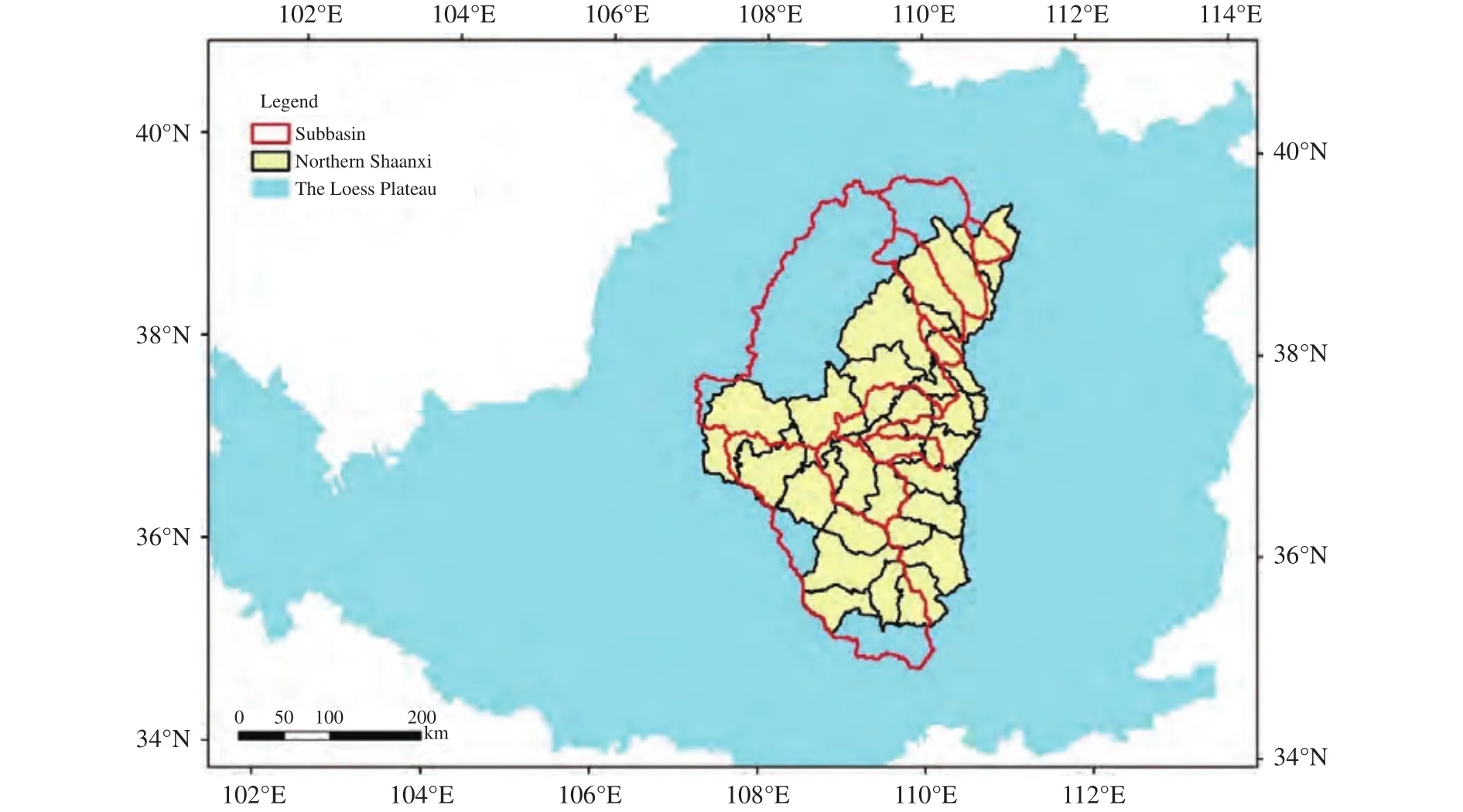
Figure 1 Geographical location of the study area
2.3 InVEST model
Based on the ArcGIS platform or as a stand-alone,the InVEST model has been transformed into software tools using Python as the scripting language.According to the specific assessment projects, input data, and parameters in the corresponding module,this model software includes three major modules(fresh-water ecosystem, marine ecosystem, and terrestrial ecosystem) that can present the evaluation results as a series of thematic maps (He and Sun, 2016).
The most important feature is that the quantified ecosystem services can be displayed in the form of maps and no longer expressed in cumbersome formulas or too much text. Second, the InVEST model relative to other ecosystem-services assessment models import the data is less. The InVEST model consists of multiple modules, which can be combined for multi-scale and multi-context analysis in multi-level design (Wuet al., 2013).
2.3.1 Carbon module
The InVEST carbon-storage module includes four carbon pools: above-ground carbon, underground carbon, soil carbon, and dead biological carbon,

In the formula,Cvis the total carbon;Caboveis the aboveground carbon;Cbelowis the underground carbon;Csoilis the soil carbon; andCdeadis the dead biological carbon. Above-ground biomass comprises all living plant material above the soil (e.g., tree and grass). Below-ground biomass encompasses the living root systems of the above-ground biomass. Soil organic matter is the organic component of soil. Dead organic matter includes litter, as well as fallen and standing dead wood (Liu and Lei, 2005; Wuet al.,2013). A fifth optional pool included in the model applies to parcels that produce harvested wood products(HWPs) such as firewood or charcoal or more longlived products such as house timbers or furniture. The model aggregates the carbon in each of the first four pools, providing an estimate of total carbon storage in each grid cell and across the whole landscape.
The InVEST carbon-storage and -sequestration model aggregates the carbon stored in these pools according to the land-use maps and classifications produced by the user.
The input data of the model are the gridded map of cells, called the raster format, of land-use type in a certain period; the output data are displayed as the grid map of raster data in ArcGIS. The input data necessary to run the model are land-use-type raster data sets. Each land-use type has a unique code, which corresponds to the carbon-pool numerical table with a unit of Mg (1 Mg=1 ton). In addition, each land-use type requires at least one of the four carbon pools. If there are more carbon pools data, the result will be more accurate.
2.3.2 Model parameters
The necessary parameters of the carbon-storage module are the current land-use/land-cover map and the carbon pool (the average value of carbon in the four carbon pools), while the optional parameters are the current harvest-rates map, future scenarios, and economic data. The carbon-storage parameters of each part of the carbon pool refer to the "2006 IPCC national greenhouse gas inventory guide" and other documents (Liu and Lei, 2005; Gao, 2014; Bao, 2015;He and Sun, 2016).
The data in Table 1 were collected from the relevant literature, based on data corresponding to the LULC types used in this paper.

Table 1 Parameters database of the carbon-pool module in the InVEST model (unit: Mg/hm2)
2.4 Data processing
The land-use data and carbon-pool parameters were input into the carbon-storage module of the In-VEST model. After running the model, we obtained the carbon-storage raster data corresponding to the LULC data. Finally, by conducting a statistical analysis of the data and calculating the total carbon content and the average value for the subregion, we obtained the spatial distribution of carbon storage(Figures 3 and 4).
3 Results and discussion
3.1 Land-use and land-cover change
Land use and land-cover change is important to conduct the simulation of carbon storage. The temporal and spatial change, tansformation of land-types, and influence factors will be analyzed as follows.
3.1.1 Temporal and spatial change
From Figures 2 and 5, it can be seen that from 1995 to 2010, the grassland area of the study area was the largest, distributed throughout the whole region;the woodland was a massive area, mainly distributed south of the Huanglong Mountains and the area of Yichuan; the water distribution was less extensive,mainly a few tributaries of the Yellow River; the concentrated distribution of unused land in the northwest of the study area is mainly sandy desert; the cultivated land area is large but scattered throughout the research area.
The area of land-use/cover types in this area changed in varying degrees over the 15 years: cultivated land and waters decreased over the years, while the forestland increased gradually; grassland and urban area decreased obviously in 1995-2000 but increased after 2000; the area of unused land during 1995-2000 increased significantly but continually decreased after 2000. In all, after the implementation of eco-construction projects in 1999, woodland and grassland area increased and has maintained a growth trend; the area of cultivated land decreased annually,but it will not continue to reduce due to the minimum level of cultivated land area established by the government; the urban area will gradually increase as urbanization develops continuously; water and unused land may decreased in the future.
3.1.2 Transformation of land-use types
From Table 2, the area of cultivated land in northern Shaanxi has reduced from 28,726 km2in 1995 to 27,129 km2in 2010, a reduction of 1,597 km2, which were mainly converted into woodland and grassland;woodland area increased 1,886 km2, which was mainly converted from cultivated land and grassland;urban area grew from 235 km2in 1995 to 331 km2in 2010, of which 41 km2of urban land was transformed from cultivated land. About 14,449 km2of cultivated land and 15,946 km2of grassland turned into other land-use types, the biggest change in area;while areas of other land types converted into cultivated land and grassland area with 12,852 km2and 14,958 km2, respectively, resulting in a corresponding reduction in the area of cultivated land and grass-land; cultivated land and grassland generally transformed into any other types, among which the conversions of cultivated land into grassland and grassland into cultivated land are the largest conversions among the reciprocal relationships; the transform in area of urban is 261 km2, and the conversion of other landuse types into urban is large when compared to the area of urban itself.
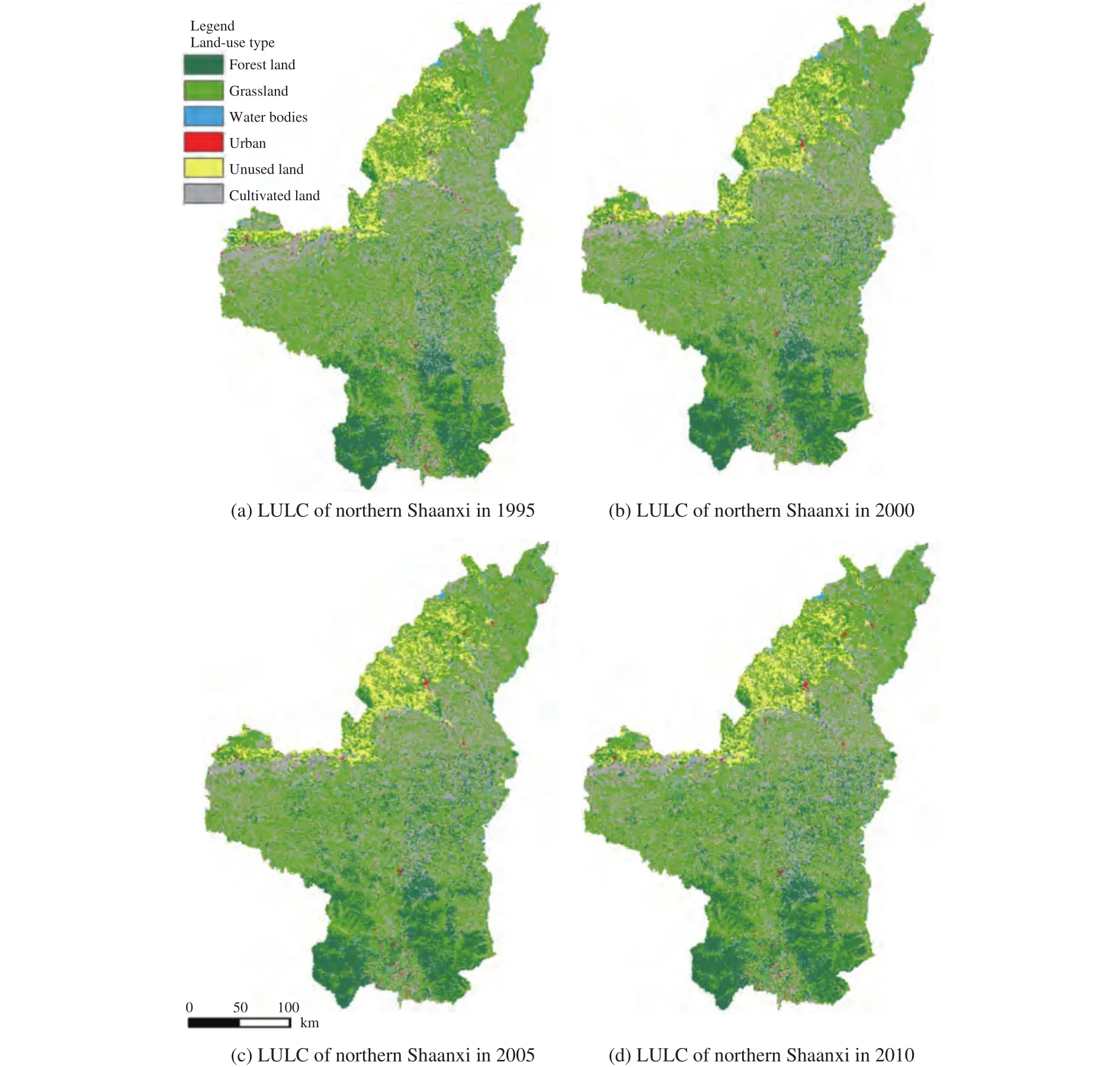
Figure 2 Spatial distribution of LULC on the Loess Plateau of northern Shaanxi, 1995-2010
3.1.3 Factors influencing LUCC
The conversion among cultivated land, woodland,and grassland is the greatest. The implementation of"returning farmland to forests" has resulted in the conversion of 47.8% of cultivated land into woodland and grassland. By 2010, the area of cultivated land had been reduced by 1,597 km2. Due to the staggered production of agriculture and animal husbandry in northern Shaanxi and the reclamation of uncultivated land(Liu, 2009), over 30% of the woodland and grassland were converted into cultivated land and other types of land use. The mineral resources in northern Shaanxi are rich; economic and urban development increased the urban area by 40.9%; unused land increased by 16.6%.
To sum up, there are mainly three driving forces behind the LUCC in northern Shaanxi: nature (including geology, climate, and hydrology), social economy (land reclamation and urban expansion), and government policies (ecological construction,etc.).The natural factors are fundamental and decisive; economic development affects short-term changes; and the impact of government policies is long-term.
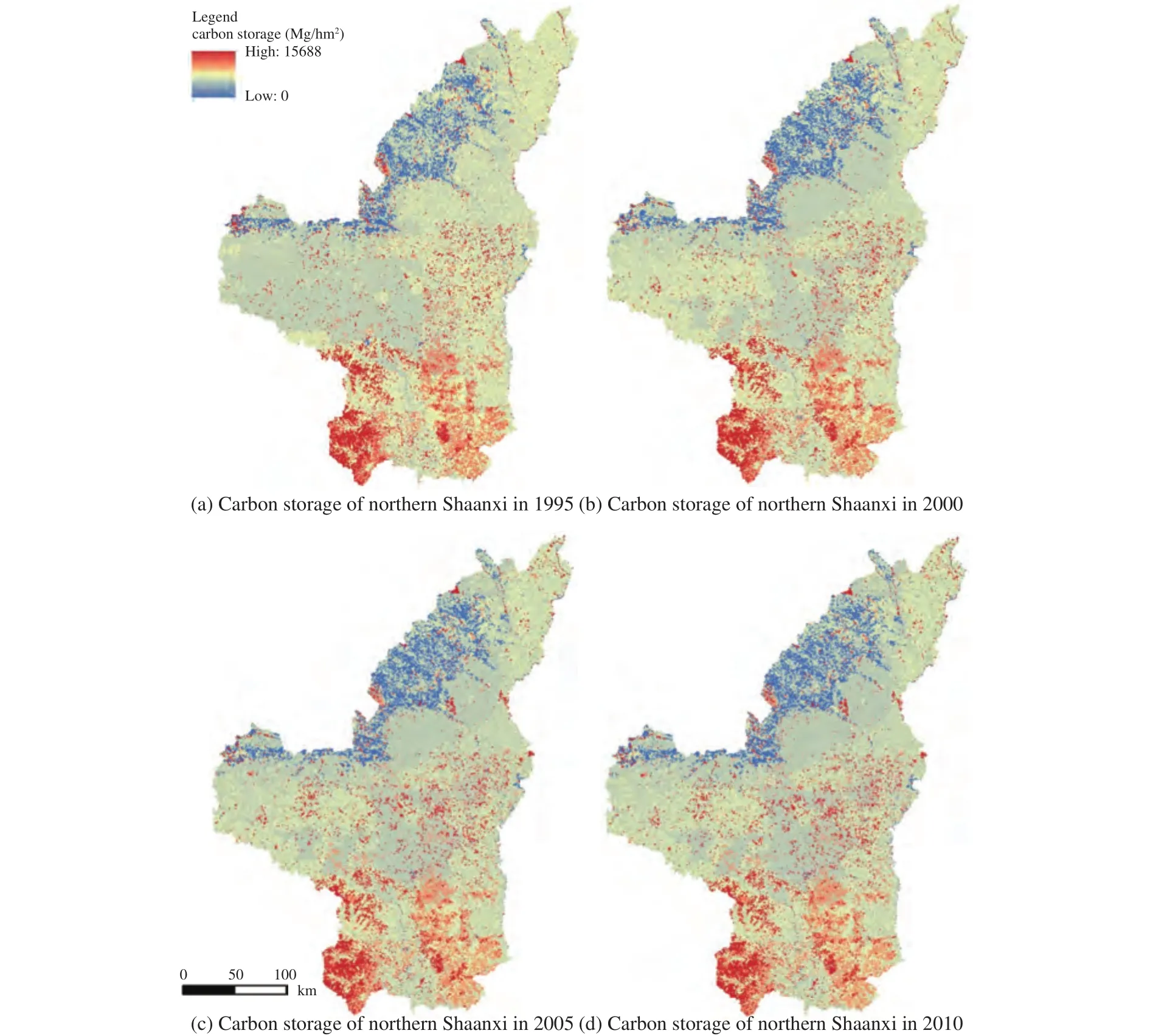
Figure 3 Spatial distribution of the average carbon stock on the Loess Plateau of northern Shaanxi
3.2 Carbon-storage change
As seen from Figures 3 and 4, the average carbon storage of the study area is not large. The largest carbon storage belongs to the southern woodland; and the carbon storage of the northwest region, dominated by the Gobi Desert, as well as the middle region,dominated by urban land, is less.
The total carbon storage in the administrative region of northern Shaanxi increased by 13,138,711 Mg,averaging 39.7506 Mg per hectare. Comparing the change of land-use types (Table 2), the increase of total carbon storage is mainly due to the larger growth of the woodland area. Although cultivated land, grassland, and others have decreased, the carbon-sequestration capacity of woodland is much greater than that of cultivated land and grassland (Huang, 2015). The increase of carbon storage shows that the vegetation in the study area has increased, and the potential of carbon sequestration is stronger.The total carbon storage in the subbasin area decreased by 7,562,294 Mg, averaging 9.6847 Mg per hectare. The whole subbasin includes the northwestern part of the administrative region of northern Shaanxi; and the forest area in the south is less, while the northwest region is grassland and unused land (desert and Gobi). Then, according to Table 2,grassland area decreased; and unused land area increased in the 15 years. The decrease of carbon storage in the subbasin may be due to the limitations of natural conditions such as soil and climate in northern Shaanxi.
3.2.1 Spatiotemporal variation of carbon storage in countiesAt the county scale, from Figure 6, the average carbon storage in northern Shaanxi counties varied considerably from 1995 to 2000. The average carbon storage changed greatly for Wuqi County(16.715 Mg/hm2), Hengshan District (8.997 Mg/hm2),and Zhidan County (7.179 Mg/hm2). Combined with land-use and land-cover change, the carbon storage in these counties is related to the increase of woodland, urban, and unused land area and the decrease of grassland and cultivated land. Over the years, the average carbon storage in Yuyang District was the least (24.955 Mg/hm2), and Huangling County average carbon storage was the most (82.117 Mg/hm2),which has a strong relationship with the type of land cover: urban area dominated in the Yuyang District and woodland in Huangling County. Overall, the average carbon storage in northern Shaanxi increased after 2000, with a slow overall growth rate.
3.2.2 Spatiotemporal variation of carbon storage in subbasins
As can be seen from Figure 7, at the subbasin scale, the carbon-storage change from 1995 to 2000 is the biggest, including the 10.62 Mg/hm2decrease in carbon storage of the Jialu River Basin and the increase of 4.30 Mg/hm2of the Beiluo River Basin.The smallest change was the Xinshui River Basin,with an increase of 0.15 Mg/hm2. After the year 2000,the average carbon storage of each subbasin has changed, showing the trend of growth. Over the 15 years, the average carbon storage of the Beiluo River Basin was 59.44 Mg/hm2, which was the most; and the Xinshui River Basin was 15.60 Mg/hm2, which was the minimum.From 1995 to 2000, there is significant reduction in carbon reservation of other subbasins, except for the Yan River Basin and the Beiluo River Basin. As shown in Figure 5, the "returning farmland to forests and grass" had just been implemented, resulting in a decrease in cultivated land and a significant increase in unused land area. Although the woodland area had increased, the carbon-sequestration capacity of the newly planted trees was not significant. After 2000,the carbon storage in the subbasins gradually increased.

Figure 4 Spatial distribution of average carbon stock in the subbasin on the Loess Plateau of northern Shaanxi

Figure 5 Changes of LULC on the Loess Plateau of northern Shaanxi

Table 2 Conversion of land-use types from1995 to 2010 (unit: km2)
3.2.3 The relationship between subbasins and countiesThe area of the subbasins (95,415 km2) is larger than that of the counties of northern Shaanxi(79,849 km2), but the average carbon storage is less.In 2010, the total carbon storage in the subbasins was 400,350,282 Mg, with an average of 40.63 Mg/hm2;and the total carbon storage in northern Shaanxi was 377,343,895 Mg, with an average of 47.19 Mg/hm2.
The subcatchment that covers most of the counties of northern Shaanxi also includes the Mu Us Desert in the northwest and seldom contains the southern forestland. Deserts have low carbon-storage capacity,and forestland has the high. Therefore, the average carbon storage in the subbasin is less than that in the northern Shaanxi.
The distribution of carbon storage in subbasins and counties is closely related to the overall natural conditions and land-use landscape in the study area.The northern part of the study area is mainly dominated by unused land such as sandy land. Carbon stocks in subbasins and counties in the area are generally low. For example, the average carbon storage in the Xinshui River Basin is only 15.73 Mg/hm2and in the Wuding River Basin, 29.90 Mg/hm2; the average carbon storage in Yuyang District is 24.45 Mg/hm2,and in Shenmu County is 37.92 Mg/hm2. The southern part of the study area is mountainous, with high vegetation coverage and high average carbon storage.The average carbon storage in the Beiluo River Basin(60.90 Mg/hm2in 2010) and Huangling County(82.29 Mg/hm2in 2010) is the highest in the study area. The topography of the central part of the study area mainly consists of plateau and gully; the terrain is broken. The types of surface cover are sparse woodland and grassland. The average carbon storage in this area is between that of the north and the south.
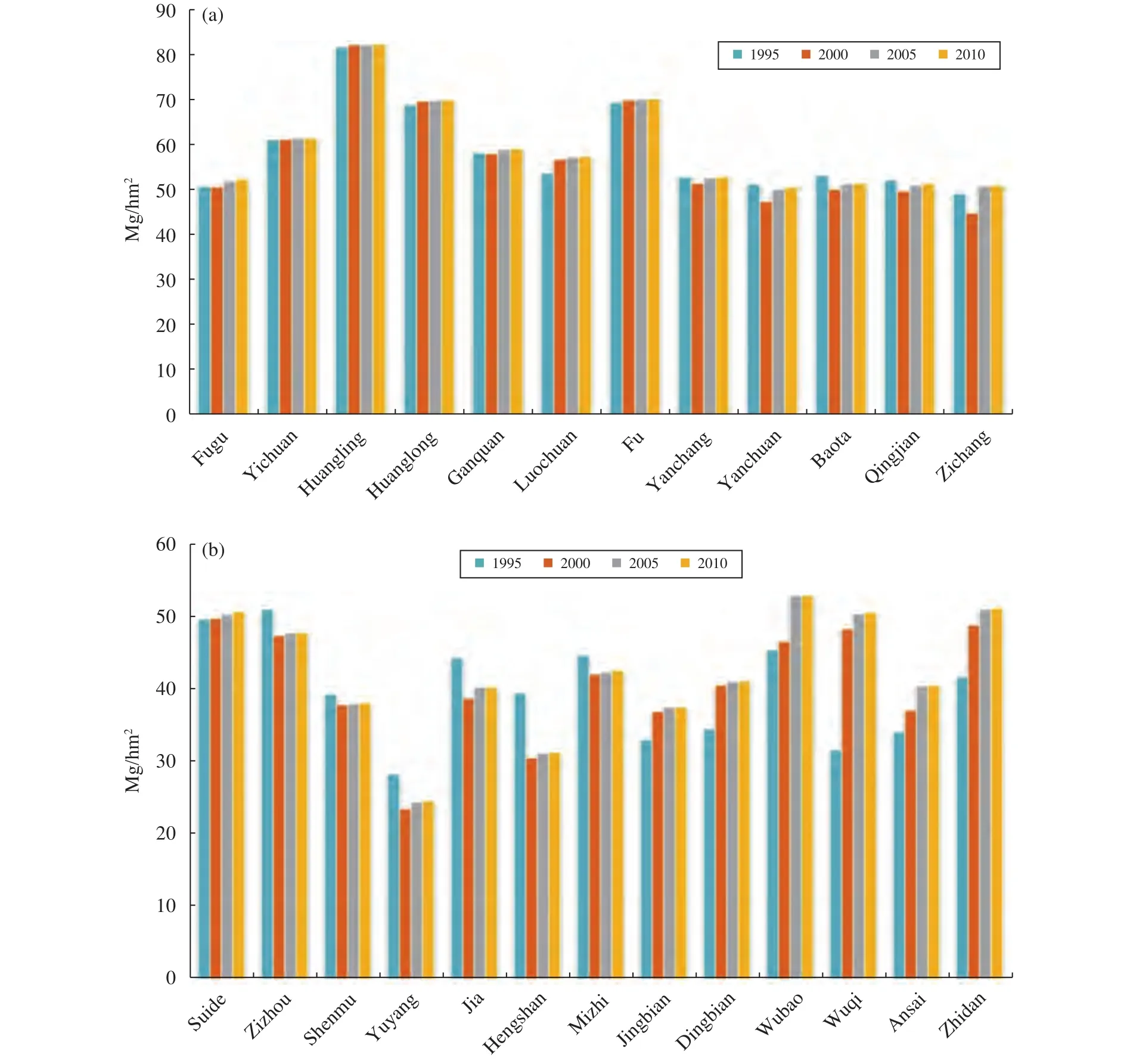
Figure 6 Average carbon-stock in changes of LUCC on the Loess Plateau of northern Shaanxi
4 Conclusion
Combining the land-use data and the InVEST model, this paper made a comparative analysis of the land-use and land-cover change (LUCC) and the carbon-stock change in the social unit (administrative counties) and the natural unit (branch basins of the Yellow River) from 1995 to 2010. The main conclusions are as follows:
(1) During 1995-2010, the area of each type of land use in the study area generally changed. The grassland, cultivated land, and water area, respectively, decreasedby 988 km2, 1,597 km2, and 61 km2,while the woodland, urban, and unused land, respect-ively, increased by 1,886 km2, 96 km2, and 667 km2.These changes were mainly influenced by natural conditions and socioeconomic and government policies.
(2) At the county scale, the average carbon storage was large in the southern region and small in the northern region. Over the 15 years, the average carbon storage in the Hengshan District decreased by 8.997 Mg/hm2and increased by 16.715 Mg/hm2in Wuqi County, which are the biggest changes. The average carbon storage of the whole northern Shaanxi increased from 45.546 Mg/hm2in 1995 to 47.189 Mg/hm2in 2010, and the total carbon storage increased by 13,138,711 Mg.
(3) On the subbasin scale, the average carbon storage of the whole subbasin of northern Shaanxi decreased from 41.402 Mg/hm2in 1995 to 39.807 Mg/hm2in 2000 and then increased to 40.635 Mg/hm2in 2010, with the total carbon storage reduced by 7,562,294 Mg in the 15 years. The carbon storage in the Xinshui River Basin was less, increased continuously in Beiluo River Basin and the Yan River Basin,decreased sharply in 2000, and then increased slowly in other subbasins.
(4) The carbon storage of subbasins and counties was restricted by the natural status and land-use landscape of the whole study area. The carbon storage in subbasins and in counties have a strong interrelationship in terms of spatial location.
(5) From the results, it can be seen that the effect of ecological policies is remarkable. It has important reference value for the rational planning of land use,adjustment of the ecosystem carbon cycle and related policies. However, the extent of change in habitat in different regions was different. In addition to the other problems brought by urbanization, the analysis of specific effects still needs further study.
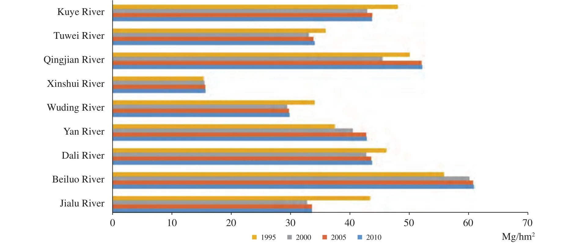
Figure 7 Average carbon-stock in the subbasin
Acknowledgments:
This research was supported by the National Natural Science Foundation of China (NSFC) project (No.41701478) and by the Natural Science Basic Research Plan in Shaanxi Province of China (No. 2017JQ4016).
:
Bao YB, 2015. Temporal and spatial change of ecological services on Loess Plateau of Shaanxi by InVEST model. Xi'an: Northwest University.
Delphin S, Escobedo FJ, Abd-Elrahman A,et al., 2016. Urbanization as a land use change driver of forest ecosystem services. Land Use Policy, 54: 188-199. DOI: 10.1016/j.landusepol.2016.02.006.
Gao Y, 2014. Carbon density and storage of forest and grassland ecosystems in the Loess Plateau region. Xianyang: Northwest A&F University.
Goldstein Joshua H, Giorgio Caldarone, Thomas Kaeo Duarte,et al.,2012. Integrating ecosystem-service tradeoffs into land-use decisions. Proceedings of the National Academy of Sciences of the United States of America, 109(19): 7565-7570. DOI:10.1073/pnas.1201040109.
He CY, Zhang D, Huang QX,et al., 2016. Assessing the potential impacts of urban expansion on regional carbon storage by linking the LUSD-urban and InVEST models. Environmental Modelling &Software, 75: 44-58. DOI: 10.1016/j.envsoft.2015.09.015.
He T, Sun YJ, 2016. Dynamic monitoring of forest carbon stocks based on the InVEST model. Journal of Zhejiang A&F University,33(3): 377-383. DOI: 10.11833/j.issn.2095-0756.2016.03.002.
Huang CH, Yang J, Zhang WJ, 2013. Development of ecosystem services evaluation models: research progress. Chinese Journal of Ecology, 32(12): 3360-3367. DOI: 10.13292/j.1000-4890.2013.0513.
Huang H, 2015. Research on land use/land cover change and carbon storage based on InVEST model. Beijing: China University of Geosciences.
Liang YJ, Liu LJ, Huang JJ, 2017. Integrating the SD-CLUE-S and In-VEST models into assessment of oasis carbon storage in north-western China. PLOS One, 12(2): e0172494. DOI: 10.1371/journal.pone.0172494.
Liu H, Lei RD, 2005. Research methods and advances of carbon storage and balance in forest ecosystems of China. Acta Botanica Boreali-Occidentalia Sinica, 25(4): 835-843. DOI: 10.3321/j.issn:1000-4025.2005.04.036.
Liu JF, 2009. Analysis on land-use dynamic change of the North Shaanxi Loess plateau. Xianyang: Northwest A&F University.
Mu XM, 2002. Impacts of soil and water conservation on river flow and soil-hydrology on the Loess Plateau. Xianyang: Northwest A&F University.
Nelson E, Mendoza G, Regetz J,et al., 2009. Modeling multiple ecosystem services, biodiversity conservation, commodity production,and tradeoffs at landscape scales. Frontiers in Ecology and the Environment, 7(1): 4-11. DOI: 10.1890/080023.
Song FQ, Kang MY, Chen YR,et al., 2009. Estimation of vegetation netprimary productivity on North Shaanxi Loess Plateau. Chinese Journal of Ecology, 28(11): 2311-2318. DOI: 10.13292/j.1000-4890.2009.0362.
Tang Y, Zhu WP, Zhang H,et al., 2015. A review on principle and application of the InVEST model. Ecological Science, 34(3):204-208. DOI: 10.14108/j.cnki.1008-8873.2015.03.032.
Wang CQ, Meng XM, Zhang XG,et al., 2009. Progress studies on carbon budget/carbon cycle in terrestrial ecosystem. Resource Development & Market, 25(2): 165-171. DOI: 10.3969/j.issn.1005-8141.2009.02.021.
Wang D, She D, Zhang F,et al., 2014. Advances in the researches of carbon storage of forest ecosystems. Journalof Northwest Forestry University, 29(2): 85-91. DOI: 10.3969/j.issn.1001-7461.2013.04.15.
Wang F, Mu XM, Zhang XP,et al., 2005. Effect of soil and water conservation on runoff and sediment in Pianguan River. Science of Soil and Water Conservation, 3(2): 10-14. DOI: 10.3969/j.issn.1672-3007.2005.02.003.
Wang YZ, 2010. Evaluate effect of converting cultivated land to forest in North Shaanxi Province of Loess Plateau. Xianyang: Northwest A&F University.
Wu SN, Li YQ, Yu DP,et al., 2015. Analysis of factors that influence forest vegetation carbon storage by using the VAR model: a case study in Shanxi Province. Acta Ecologica Sinica, 35(1): 196-203.DOI: 10.5846/stxb201405291107.
Wu Z, Chen X, Liu BB,et al., 2013. Research progress and application of InVEST model. Chinese Journal of Tropical Agriculture,33(4): 58-62. DOI: 10.3969/j.issn.1009-2196.2013.04.012.
Xi J, 2006. Study on Conversion of Farmland to Forest and Eco-environment Construction in Loess Plateau of Northern Shaanxi Province. Xi'an: Northwest University.
Zhang YQ, Zhang XX, Chen ZJ,et al., 2016. Research on the spatiotemporal variation of carbon storage in coastal zone ecosystem of Jiangsu based on InVEST model. Research of Soil and Water Conservation, 23(3): 100-105. DOI: 10.13869/j.cnki.rswc.2016.03.018.Zhao MW, Yue TX, Zhao N,et al., 2014. Combining LPJ-GUESS and HASM to simulate the spatial distribution of forest vegetation carbon stock in China. Journal of Geographical Sciences, 24(2):249-268. DOI: 10.1007/s11442-014-1086-2.
杂志排行
Sciences in Cold and Arid Regions的其它文章
- Tessellons, topography, and glaciations on the Qinghai-Tibet Plateau
- Characteristics of total suspended particulates in the atmosphere of Yulong Snow Mountain, southwestern China
- Spatial variations of Pb, As, and Cu in surface snow along the transect from the Zhongshan Station to Dome A, East Antarctica
- Multifractal process of runoff fluctuation of the Kaidu River in Xinjiang, China
- Comprehensive benefits assessment of the ecological management model in Hobq Desert of China
- Characterization of landscape pattern based on land economic niche change: A case study in Ganzhou,Gansu Province, China
