BDS: Weaving a Global Navigation Network
2018-06-14byZhangXue
by Zhang Xue
When Chinas homegrown satellite navigation system, named after “Beidou,”began operation in 2003, China became the third country to operate a self-developed satellite navigation system, following the United States and Russia.
The third phase of the BDS, known as BeiDou-3, began construction in 2017 and will be ready to serve the whole globe by 2020.
With the BDS expanding from a domestic navigation system to a global network, China is making a crucial breakthrough in technological innovation in the new era.
Catching Up
Compared to the other three global navigation satellite systems, the United StatesGPS, Russias GLONASS and the European Unions Galileo, Chinas BDS is the newest on the scene.
The BDS project was first launched in the 1980s with an aim to fulfill the Chinese dream of developing its own satellite navigation system. However, not until 1994 did China start working on the BeiDou Satellite Navigation Experimental System, known as BeiDou-1. In late 20th century, China explored its own path and made plans to develop BeiDou-1, 2 and 3 consecutively.
Three positioning satellites constituted the BeiDou-1 navigation system, two of which were launched in 2000 and the other in 2003. With only three satellites, the system managed to provide regional service. The success in the formation of the BeiDou-1 network made China the third country to own a homegrown satellite navigation system and marked the dawn of the BDS service era.
China had accelerated development of the BeiDou-2 navigation system since 2007 and completed networking on its 16 satellites in December 2012. The BeiDou-2 system began operation with expanded service to the Asia-Pacific region, providing navigation, positioning and time services.
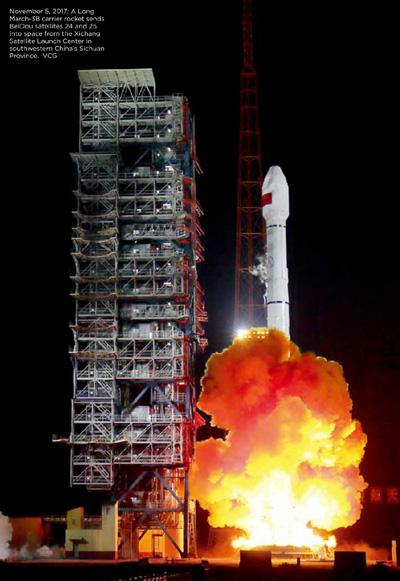
In November 2017, China launched two satellites for the BeiDou-3 navigation system from the Xichang Satellite Launch Center in the southwestern province of Sichuan. The BeiDou-3 era has almost arrived.
A Long March 3B/YZ-1 rocket launched BeiDou satellites 28 and 29 into space on February 12, 2018. This year will bring frequent launches with 18 BeiDou-3 satellites scheduled to go into space by the end of 2018. The global network of the BeiDou-3 navigation system with 30 satellites will take shape with global coverage by the end of 2020.
The BeiDou-3 navigation system, inheriting advantages of previous BeiDou systems, will provide more precise location than the BeiDou-2 by 100-200 percent. China aims to provide more efficient and accurate measurement of time and space.
Serving Civilians
As opposed to military use, the BDS is more applicable to civilian service. The system has been widely employed in public security, transportation, fishery, power industry, forestry, disaster relief and more. It brought drastic changes to the construction of smart cities and social governance, catching eyes worldwide.
The BDS has formed an integral industrial system that combines basic products, application terminals and operation service, deeply integrating with various economic sectors.
At the fifth anniversary of the beginning of service of the BeiDou-2 navigation system last December, Chinas State Council Information Office held a press conference to report on its achievements.
Ran Chengqi, director of Chinas Satellite Navigation System Management Office and spokesperson for the BDS, said that the BDS integrates with the internet, cloud computing and big data to build a cloud service platform that provides highly precise information on time and space. He added that the auxiliary BeiDou satellite positioning system covers more than 200 countries and regions with over 100 million users and over 200 million uses daily.
According to Chinas Ministry of Transport, the BDS formed the worlds largest automobile positioning network in China in 2016, with 4.8 million transport vehicles equipped with the BDS hitting road. Its data shows that the system saved one-third of travel time and reduced severe accidents by half. More than 40,000 fishing boats have been equipped with the system. It is estimated that the BDS has saved more than 10,000 fishers since 2003. With the BDS, the time it takes to report severe disasters to authorities dropped to less than an hour, and the efficiency of aid and emergency response doubled. The BDSbased service has expanded to areas like precision agriculture, monitoring building dangers and unmanned driving.
Today, the BDS is becoming a must-have for mobile phones in China. Shared bikes use the system to realize precise management and more devices equipped with the BDS such as watches, sporting wristbands and student cards are incorporating the invisible system into everyday life.
Open Arms
Developers of the BDS built the system for the world as well as for China, so it should be compatible with other satellite navigation systems and advance together with them.
The BDS is integrating globally with increasing international cooperation, evidenced by the establishment of the Project Committee on China-Russia GNSS Cooperation as well as China-U.S. and ChinaEU joint working groups on satellite navigation. China has contributed to win-win cooperation between multiple navigation systems by jointly building a platform to monitor satellite navigation with Russia and signing joint statements on compatibility and interoperability between satellite navigation systems with both Russia and the United States.
“The BDS has become the third satellite navigation system recognized by the International Maritime Organization,”revealed Ran. “It is also the core constellation for satellite navigation recognized by the International Civil Aviation Organization. The system has gained international resources to support its satellite-based augmented service and provides free search and rescuing services around the whole world. Also, the international standards of the third and fourth generations of BDS-based positioning technology for mobile communication have already been published.”
Early in December 2017, China and the United States signed a joint statement on civil signal compatibility and interoperability between BDS and GPS. The two systems will realize interoperation in civilian signals. After the two navigation systems link with each other, one terminal can receive signals from both, largely improving the stability and accuracy of positioning.
The BDS has been recognized by the International Civil Aviation Organization, the International Maritime Organization and the Third-Generation Mobile Communication Standard Partnership Project. It covers nearly three billion people in more than 50 countries and regions and has become a new calling card to inspire people to learn about China.