SuperView-1-China’s First Commercial Remote Sensing Satellite Constellation with a High Resolution of 0.5 m
2018-02-20WANGSaiJINRenZHUJidong
WANG Sai, JIN Ren, ZHU Jidong
Beijing Space View Technology Co.,Ltd., Beijing 100089
Abstract: SuperView-1 satellite constellation (SuperView-1 for short) is the first commercial remote sensing constellation with a resolution down to 0.5 m. It’s an important part of the national spatial information infrastructure construction. It will play an important role for the global users providing remote sensing data, application solutions and remote sensing value-added services with its high-resolution and 24-hour observation capability. At present, 4 satellites of the constellation have been successfully launched and networked on orbit. The services cover surveying and mapping, land resource surveying, urban planning, agriculture, forestry, water conservancy, geological mining, environmental monitoring, defense, disaster reduction along with other traditional industries. There are also great potential applications in Mobile Internet, LBS, Smart city, insurance and other emerging professions. The successful operation of SuperView-1 breaks the overseas monopoly for commercial high-resolution remote sensing satellite imagery in the China market.It’s one of the major achievements in China space science and technology by actively exploring the development of commercial remote sensing markets, which is of strategic significance to the development of China remote sensing satellite business.
Key words: SuperView-1, commercial remote sensing satellite, application
1 INTRODUCTION
With globalization, the rapid development of aerospace technology and with the influx of commercial capital, satellite remote sensing technology continues to expand and touches all areas of society. Global commercial remote sensing satellites have entered a period of comprehensive innovation in terms of technology and industrialization. The SuperView-1 satellite constellation is a pioneer in establishing a commercial remote sensing satellite system for China Aerospace Science and Technology Corporation, which not only breaks the dependency on overseas high-resolution commercial remote sensing satellites in the Chinese market, but also lays a solid foundation for the development of commercial remote sensing satellites in China.
SuperView-1 satellite constellation will provide remote sensing data, application solutions and value-added services with its high-resolution and 24 hour observation capability for global users. The services cover surveying and mapping, land resource, urban planning, agriculture, forestry, water conservancy, geological mining, environmental monitoring, defense,disaster reduction and other traditional industries. It also focuses on developing the potential in emerging industries such as Mobile Internet, LBS, Smart city, and insurance thus promoting the integration of remote sensing technology in China into government management, corporate production and public life[1].
2 SATELLITE OVERVIEW
The SuperView-1 satellite constellation is a commercial remote sensing satellite system. It was independently developed by China Aerospace Science and Technology Corporation and includes 0.5 m resolution optical satellites, other higherresolution optical satellites, microwave satellites, video satellites,hyperspectral satellites. SuperView-1 is the first commercial satellite constellation with agile and multi-mode imaging capabilities. The constellation will be completed by 2022, with a daily acquisition capacity reaching 12 million square kilometers after the completion of the system, which can achieve a coverage of ten major cities in China within one day. Work in parallel,with the 24-hour, all weather ability of radar satellites for Earth observation, the high resolution remote sensing data can be obtained on an hourly basis.

Figure 1 SuperView-1 satellite constellatio n
At present, four optical remote sensing satellites with up to 0.5 m resolution, SuperView-1 01, 02, 03 and 04, have been successfully networked with 90° phase difference on same orbit. They not only have a variety of acquisition modes such as scanning continuous strips, multi-striping, shooting by targets,but also have stereo acquisition capabilities and can continuously collect data according to user needs. The detailed parameters of SuperView-1 are shown in Table 1.

Table 1 The detailed parameters of SuperView-1
3 SATELLITE CHARACTERISTICS
3.1 Space-ground Integration “quasi-real-transmission”
The data transmission system of SuperView-1 satellites establishes a “data transmission link” between the satellite and ground receiving stations. It can send image information back to the ground while shooting new images, improving the transmission efficiency of the on-orbit image to the ground greatly,shortening the landing time of image data. In this way, fresher and more timely image data will be provided to the users. At the same time, the digital distribution system can also perform lossless compression on multi-spectral images to provide users with professional-grade images. The “real-time” and “lossless”transmission achieves a “quasi-real-transmission” function for SuperView-1.
In addition, building on the capability of existing ground stations in China, in order to further enhance global data reception and provide comprehensive data acquisition capabilities for the SuperView series of commercial remote sensing satellites,China and the Norwegian Konsberg Company signed a service contract for the construction of ground stations in the high latitudes above the Arctic circle. The ground stations will maximize the effective use of the SuperView-1 satellites in orbit.
3.2 Agile Action, Short Revisit Period
The SuperView-1 satellites are equipped with the newly developed variable speed control moment gyro (VSCMG) which combines the advantages of both the control moment gyroscope and the momentum wheel, making the SuperView-1 satellites highly agile. When working in the “control moment gyro” mode,it can quickly adjust the attitude of the satellite; when working in the “momentum wheel” mode, it can accurately stabilize the satellite, and it can also smoothly switch between the two modes.In this way, in terms of attitude control, SuperView-1 can be“deliberate in course” and can also be “prompt in action”.
With the SuperView-1 four-satellite network in operation,it is capable of revisiting once a day anywhere in the world.Through flexible working modes and superb integrated data acquisition and transmission capabilities, it can achieve 10 minutes of imaging per track and transmit quickly. A single satellite can collect 900,000 square kilometers per day, and four satellites will collect about 3 million square kilometers of images per day,providing 24-hour Earth observation services for global users.
3.3 Diversified Modes, High Accuracy of Mapping
SuperView-1 satellites can adjust their own pitch and roll gestures according to different satellite instructions for image shooting. This results in fix posture (Nadir) imaging, side pendulum imaging, continuous strips, multi-striping, stereo imaging,multi-target imaging and other work modes (Figure 2 - Figure 5).
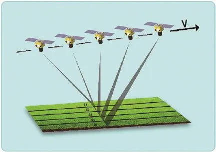
Figure 2 Multi-striping imaging
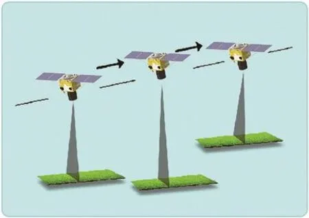
Figure 3 Multi-target imaging
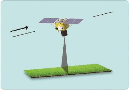
Figure 4 Continuous strips imaging
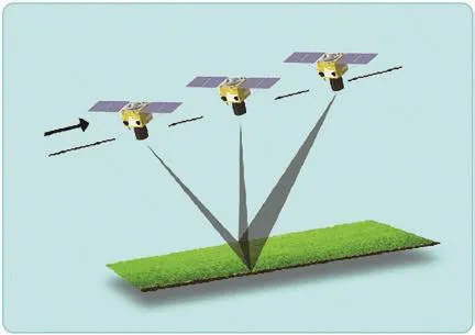
Figure 5 Stereo imaging
Under the multi-striping imaging mode and multi-target imag-ing mode it can satisfy requirements for wide-range coverage and respond to various emergency mission requirements. Continuous strip imaging mode can accumulate a global range of image data after completing the user’s imaging task for a specific area.
The stereo imaging method of SuperView-1 can be used for the acquisition of ground elevation information and the extraction of specific 3D objects. After the basic stereoscopic product has been corrected by high-precision control points,the extracted elevation model can achieve an accuracy of better than 1 meter (RMSE), and the extracted high-precision DEM(Digital Elevation Model) is used to ortho-rectify the satellite imagery, which will have an accuracy of better than 1 m (medium error). High-precision DEM imaging can provide fast and effective support for projects, such as electrical power grid engineering design and survey, and railway planning in difficult areas.Figure 6 and Figure 7 show the Ayers Mountain stereogram and shaded reshaping, on which the delicate texture of the mountain roads can be clearly seen.

Figure 6 Ayers Mountain stereogram
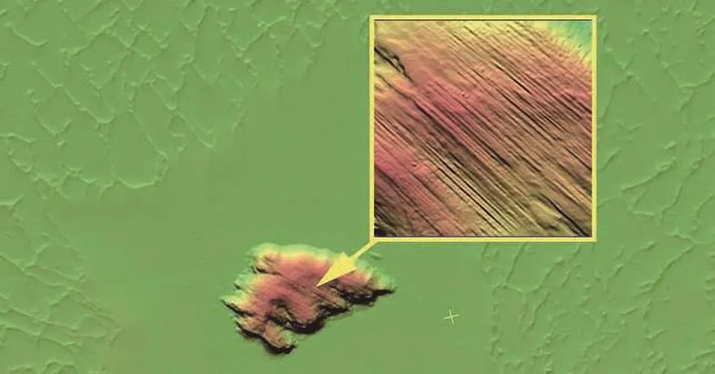
Figure 7 Ayers Mountain shaded reshaping
3.4 Stable Imaging, Better System Performance
With the development of the SuperView-1 satellites key breakthroughs in technologies such as variable speed control moment gyro, satellite fast attitude maneuver and high stability control, high orbit remote sensing satellite imaging quality assurance under complex imaging conditions were made. These key technologies allow the satellite to swiftly maneuver and maintain a stable attitude, when shooting high quality images.On this basis, the SuperView-1 development achieved a great leap-forward in the aspects such as spatial resolution, geometric positioning accuracy and image quality:
1) It operates in the panchromatic band and four standard multispectral bands. The panchromatic resolution is up to 0.5 m and the multispectral resolution is 2 m. It can determine delicate details and it is suitable for making high-precision maps, monitoring change and analyzing images in depth;
2) The swath width is 12 km, supplemented by a multistrip observation ability, which enables a large surface area observation, and has advantage for environmental monitoring;
3) The camera adopts a variety of lightweight materials such as a silicon carbide primary mirror and a lightweight ceramic material tube. A large number of mass-reducing designs features were introduced on the primary mirror and the main bearing structure, resulting in an increase in the diameter and resolution of the camera. Thus, the weight is reduced and the efficiency is improved. At the same time, the satellite has extremely high maneuverability[2];
4) The truss has been upgraded and observation imaging is no longer “shaking”. The camera of the SuperView-1 satellite is equipped with an “advanced” version of the damper truss. It not only has a large damping capacity,but also has low-frequency vibration isolation and onorbit frequency vibration isolation, which can effectively block vibrations from moving parts on the satellite and ensure quality of camera image[2];
5) In the case of no reference control points, the basic product of SuperView-1 can achieve a geographical positioning accuracy of better than 7.5 m (RMSE) within 25 degrees of the roll angle after processing with the corresponding RPB file and DEM. After processing the basic products with high-precision ground reference control points and high-precision DEM, the geolocation can achieve an accuracy better than 1 m (RMSE).
4 IN-ORBIT DATA EVALUATION
The accuracy of the SuperView-1 satellite data was evaluated by considering ortho-rectification.
The accuracy of two SuperView-1 scenes after ortho-rectification (mountain area, L1B level product and L2A level product)was evaluated and the geometric precision accuracy can reach 1.73 m and 1.53 m. See Table 2 and Table 3. Different correction models were used to correct the SuperView-1 image to obtain the accuracy assessment results (Table 4).
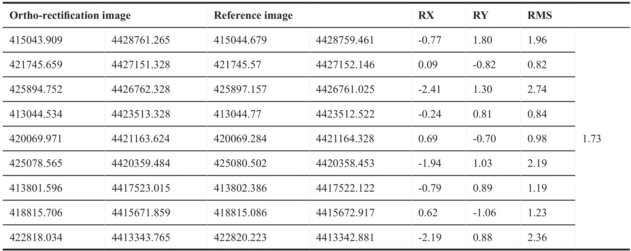
Table 2 Accuracy evaluation table of mountain area, L1B level product (Unit: m)

Table 3 Accuracy evaluation table of mountain area, L2A level product (Unit: m)

Table 4 Geometric accuracy under different correction models with control points (Unit: m)
5 IN-ORBIT APPLICATION
As a rising star in the field of remote sensing, SuperView-1 has been applied in many fields. Specifically, as follows:
5.1 Urban Planning
The resolution of the SuperView-1 satellite is up to 0.5 m.SuperView-1 can identify features and extract the boundary of the features easily. For example, SuperView-1 can recognize road networks at all levels of the city clearly, as shown in Figure 8. At the same time, by using the SuperView-1 image to extract the density of urban buildings (Figure 9), it can reflect the spatial distribution of urban buildings quantitatively and can be used as one of the important references for urban planning. In summary, SuperView-1 can provide basic geographic data in phase,timing and with different spatial levels to meet the needs for urban construction planning.
5.2 Emergency Disaster Reduction
For disaster reduction, it is an important way to reduce casualties and property damage by using a high-resolution remote sensing satellite to support disaster prevention and relief operations. Acquisition of continuous dynamic monitoring data such as that from say a typhoon devastated region can identify hazards, and during the approach identifying potential disaster targets through high-frequency repeated detection. Hence it can provide support for the analysis of disaster development trends such as floods, fires, landslides, mudslides, barrier lakes, and the deployment of disaster relief programs[3].The high temporal resolution and high spatial resolution of SuperView-1 can satisfy requirements, such as dynamic monitoring of a target area over a long period, dealing with various emergencies and critical tasks.SuperView-1 provided emergency data support for earthquake relief. After the earthquake of Xinjiang Kashgar and Sichuan Aba,it actively responded to the government’s call to provide postearthquake data for the earthquake. In addition, it was also used to shoulder international responsibility and provided post-earthquake data for the earthquakes in Mexico and Iraq.

Figure 8 Road extraction by SuperView-1
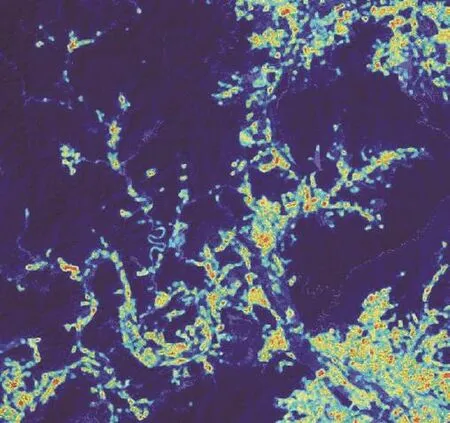
Figure 9 Building density map of SuperView-1
Take the example of the 5.5 magnitude earthquake that occurred in the early morning of May 11, 2017 in Kuzigun Village,Tashkulgan Township, Kashgar, Xinjiang. SuperView-1 responded to the disaster quickly and acquired the remote sensing images of the region on May 13, 2017. By comparing with the data of GeoEye-1 on April 10, 2015 (Figures 10 and 11), it was used to analyze the disaster conditions particularly of the houses in the area and temporary relocation sites after the disaster. It also provided the necessary information for post-disaster reconstruction and rescue.
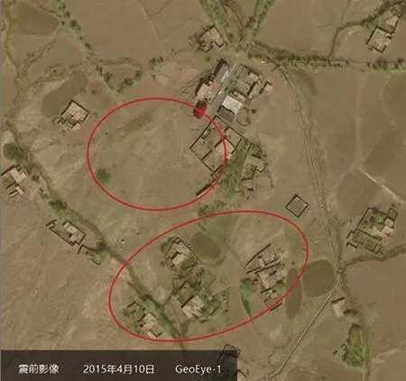
Figure 10 Pre-earthquake image of GeoEye-1

Figure 11 Post-earthquake image of SuperView-1
5.3 Emerging Profession
While SuperView-1 is widely used in traditional industries,it has gradually emerged in emerging industries such as those of Mobile Internet, LBS smart cities, and insurance. It has been used for extensive cooperation in the insurance industry, geographical information sharing, map location services, big remote sensing satellite data in agricultural insurance, and smart cities with China Ping An Property & Casualty Co., Ltd. It has established a new commercial business model for remote sensing satellite imagery, which promotes the sharing of resources and seeks complementary advantages in insurance industry and the commercial remote sensing industry, thus injecting new impetus into the development of the commercial space business.
6 CONCLUSION
The SuperView-1 satellite constellation closely revolves around the national space infrastructure construction and the development of commercial remote sensing satellites. It has conquered many research difficulties and achieved many innovations. It lays a technical foundation for the subsequent highresolution commercial Earth observing satellite system and has a pioneering significance for the development of commercial high-resolution remote sensing satellites in China.
The successful development and operation of SuperView-1 has broken the monopoly of satellite data from overseas submeter remote sensing satellites, it filled the data gap of commercial high-resolution remote sensing satellites within the Chinese satellite product line. Follow-up advanced optical satellites,microwave satellites, video hyperspectral and other micro-satellites will bring new vitality to the industry, and will contribute to the global remote sensing field. At the same time, it will spawn new and updated remote sensing application models and open up a broader market.
杂志排行
Aerospace China的其它文章
- Study on Measuring Device for Bearing Clearance of Hemisphere Dynamic Pressure Motor
- Study on Multi-Rotary Joints Space Power Satellite Concept
- Exploration of CASC’s Commercial Space
- Space Development with Chinese Characteristics and its Practical Significance
- China Successfully Launches First Operational Civil Optical Constellation
- China Launches BeiDou 3 Navigation Satellites into Space
