基于HJ卫星数据与面向对象分类的土地利用/覆盖信息提取
2017-11-24朱永森曾永年
朱永森,曾永年,张 猛
(1. 中南大学地球科学与信息物理学院,长沙 410083;2. 中南大学空间信息技术与可持续发展研究中心,长沙 410083)
基于HJ卫星数据与面向对象分类的土地利用/覆盖信息提取
朱永森,曾永年※,张 猛
(1. 中南大学地球科学与信息物理学院,长沙 410083;2. 中南大学空间信息技术与可持续发展研究中心,长沙 410083)
土地利用/覆盖信息是区域气候与环境研究的基础,是土地资源规划与管理、合理开发与保护的信息保障。为此,该文选取长株潭城市群核心区为试验区,以时间序列 HJ卫星影像为数据源,首先构建了时间序列归一化植被指数(normalized difference vegetation index,NDVI)、时间序列光谱第一主成分(first principal component,PC1)数据集,通过J-M(Jeffries-Matusita)距离变量可分离性分析结合地表覆盖的物候特征,确定最佳时序HJ组合数据;其次,采用面向对象的随机森林算法对研究区土地利用/覆盖信息进行分类,并对分类结果进行精度评价与比较分析。研究结果表明:采用时间序列HJ组合数据与面向对象的分类方法,提取城市土地利用/覆盖信息的总体精度和Kappa系数分别达到91.55%和0.90,其中水田、水浇地、旱地、林地、建设用地的生产者精度均达到90%及以上;相对于时间序列基于像元分类、单时相面向对象的分类方法,该文提出的土地利用/覆盖信息提取方法的总体分类精度和Kappa系数分别提高了2.26%、0.02和6.82%、0.08,有效提高了区域土地利用/覆盖信息提取的精度,为大范围土地利用/覆盖精细化分类提供了有效的途径。
土地利用;遥感;分类;时间序列;面向对象;土地利用/覆盖分类;城市区域;HJ卫星
0 引 言
土地利用/覆盖信息是全球及区域环境研究的重要基础,是土地动态监测、规划与管理、合理开发与保护等工作的信息保障[1]。近年来,快速城镇化使得城市及周边的土地利用和覆盖信息发生了剧烈的变化,建设用地日益紧缺,耕地非农化现象突出[2]。因此,及时准确、有效地监测城市区域土地利用/覆盖状况,对区域气候与环境研究、城市土地资源的合理开发与利用均具有重要的理论与现实意义。
遥感技术具有宏观、时效、连续、综合等特点,已成为土地利用/覆盖信息提取的重要手段[3-6],且快速发展的城市区域土地利用/覆盖遥感动态监测越来越依赖于高时空分辨率的遥感数据。在众多中高分辨率遥感影像中,具有较高分辨率及可持续获取能力的Landsat数据已成为城市区域土地利用/覆盖信息提取的主要数据源[7-9],但受其重访周期与天气的影响,难以获取时间序列的Landsat影像数据[10-11]。因此,目前在对城市土地利用/覆盖信息提取的研究中,主要依赖于单时相Landsat数据[12-18]。但是,对于地表异质性程度较高的城市区域而言,由于同物异谱、同谱异物现象的存在,利用单时相影像数据来提取城市土地利用/覆盖信息的精度受到一定程度的影响。
中国环境卫星CCD数据空间分辨率为30 m,A、B双星组合可实现2 d重访的高时间分辨率,为快速准确提取大范围土地利用/覆盖信息提供新的途径[19],在土地利用/覆盖分类[20-21]、农作物种植信息提取[22-23]、湿地信息提取[24]方面得到广泛的应用。目前,尽管时间序列的环境卫星数据得到了有效的应用,但遥感分类方法多采用基于像元的分类算法。仲波等通过构造时间序列的环境卫星数据,采用支持向量机的分类方法对辽宁大伙房水库区域和青海黑泉水库区域的土地覆盖景观进行提取[21]。于文婧等利用多时相HJ-CCD数据建立典型地物的NDVI(normalized difference vegetation index)时间序列曲线,通过提取物候模式的时序特征参数,采用基于像素的CART决策树算法对干旱半干旱灌区土地利用信息进行提取分类[20]。然而,基于像元的分类方法忽略了影像丰富的几何形状、纹理、拓扑关系和空间特征等信息,分类结果不可避免地会产生“椒盐”现象,这在异质性较强的城市区域尤为显著[25-26]。面向对象分类方法作为一种新的分类技术,不仅充分利用了遥感影像的光谱信息,而且顾及地理对象的空间分布特征及相关性,能够有效弥补传统基于像元分类方法的不足[27-29]。因此,充分利用环境卫星数据的时间、空间、光谱与几何信息,采用面向对象方法及机器学习算法,对进一步提高土地利用/覆盖信息提取的精度具有重要的意义。
为此,本研究选用长株潭城市群核心区作为试验区,基于时间序列HJ组合数据,采用面向对象的机器学习算法,研究城市区域土地利用/覆盖信息提取的技术方法,试图为高异质性城市区域土地利用/覆盖信息的有效提取提供更加准确、高效的技术方法与途径。
1 研究区及数据
1.1 研究区概况
研究区位于湖南省的东北部,包括长沙、株洲、湘潭的主城区及邻带的郊区部分,位于 112°40′E~113°24′E,27°40′N~28°25′N,三市沿湘江呈“品”字形分布(图1所示),为湘中部丘陵与洞庭湖冲积平原的过渡地带,连接中国北部和南部城市的重要经济纽带,是长江中游城市群的重要组成部分。研究区地处低纬度,属较典型的大陆性中亚热带季风湿润气候,四季分明,降雨充沛,年均气温16~18 ℃,年均降水量1 400 mm左右。研究区面积 5.60×10³km2,约占全省总面积的2.64%。近年来,随着长株潭城市群建设进程的加快,建设用地迅速扩张,耕地、林地面积显著减少,土地利用结构发生较大的变化,土地生态系统变化显著。
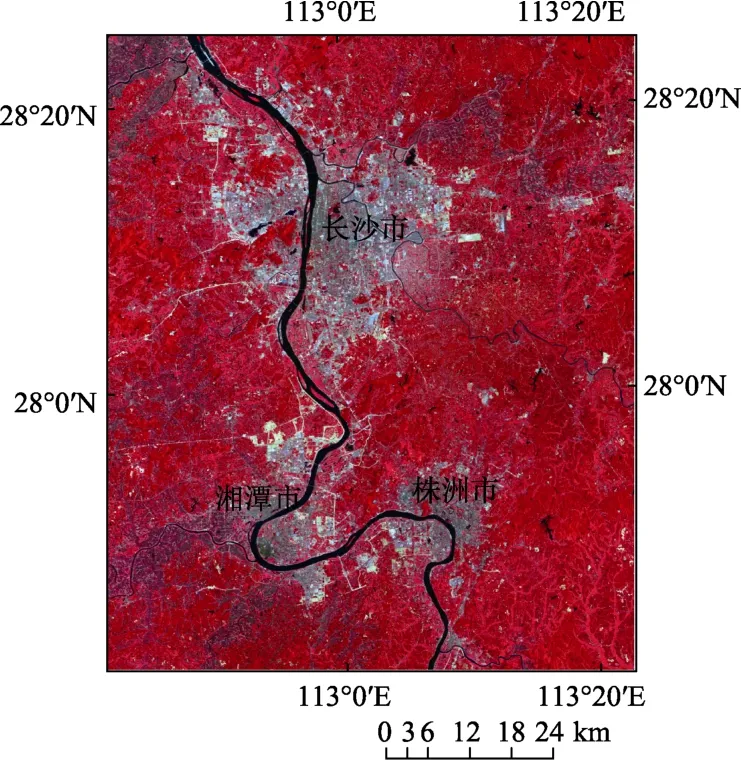
图1 研究区2014年7月30日HJ-CCD影像(假彩色合成)Fig.1 HJ-CCD image of study area on July 30, 2014 (false color synthesis)
1.2 数据来源与处理
本研究所需的遥感影像数据为HJ-1A/1B CCD数据2级产品,均通过中国资源卫星应用中心查询并免费下载。根据可获得的环境卫星数据的日期、数据质量以及植被生长的物候期规律,选取的HJ-CCD影像如表1所示。下载的环境卫星数据分辨率为30 m,数据质量良好。
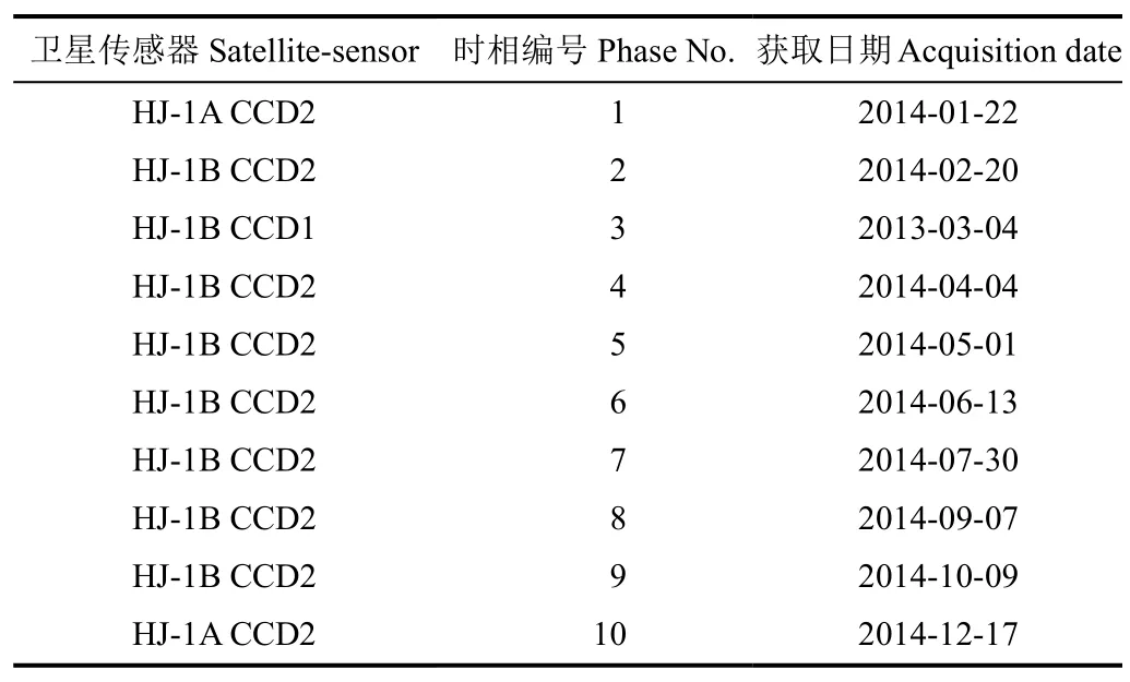
表1 研究区HJ-CCD影像数据列表Table 1 HJ-CCD images data list of study area
利用ENVI 4.8图像处理软件中的FLAASH大气校正模块,根据中国资源卫星应用中心提供的定标系数和参数构造波谱响应函数,对影像进行辐射定标和大气校正;以1∶50 000地形图为参考对研究区TM影像进行几何校正,然后以 TM 影像为基准,利用二次多项式和双线性内插法对各期环境卫星影像进行精确几何校正并与基准影像进行配准,RMS控制在0.5个像元以内;最后对经过处理的数据按研究区边界矢量图进行裁剪。
以研究区实地考察采样数据、长株潭土地利用现状图(2013年)、Google Earth高分辨率遥感影像、研究区2014年10月GF-1影像作为分类的地面验证数据,验证样本根据各种地类面积比例均匀分布于研究区。
2 研究方法
本研究首先通过构造 NDVI和光谱主成分时间序列曲线及地类统计分析,计算典型植被类型间的 J-M 距离进行可分离性分析,确定研究区最佳时间序列HJ组合数据;其次,利用eCognition 9.0进行多尺度分割,采用面向对象的随机森林分类算法对研究区土地利用/覆盖信息进行提取;最后,对比分析该方法与时间序列基于像元分类以及单时相面向对象分类方法的精度和优势,研究技术流程如图2。
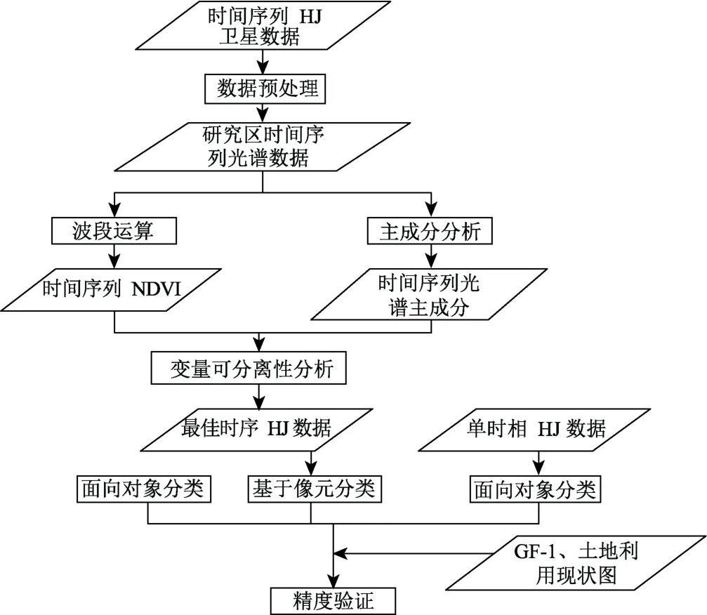
图2 技术流程图Fig.2 Technology flow cart
2.1 NDVI时间序列数据集的构造
归一化植被指数(NDVI)是监测植被生长状态的最佳指示因子,时间序列 NDVI曲线反映了植被物候特征随时间的变化,可有效区分不同的土地覆盖类型。为此,利用近红外和红波段的反射率计算NDVI,构建时间序列的NDVI数据集,并利用不同土地利用/覆盖样本,结合时间序列的NDVI数据集获得不同地类的NDVI时间变化曲线(图3)。
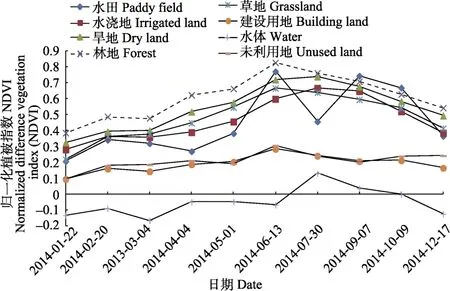
图3 各地类的NDVI时间序列曲线Fig.3 NDVI time series curve of each land type
NDVI时间序列曲线表明:水体的NDVI值在0附近上下波动,其他地类的NDVI值均大于0;建设用地和未利用地的NDVI曲线较平稳且相似,利用时间序列NDVI区分它们有一定的难度。耕地的 NDVI时间序列曲线在生长期有明显的1个或2个波峰,研究区水田主要以双季稻为主,在6月生长期处于一个波峰,在7月收割期有个明显的波谷,到10月成熟期又达到波峰;水浇地在7月和9月为生长旺盛期,该时期处于波峰,而在10月已基本完成收割,NDVI值急剧减小,用该时期的影像可有效区分于其他植被;旱地的NDVI曲线与水浇地相似,但是各期的 NDVI值明显高于水浇地;林地和草地的生长周期较长且NDVI曲线相似,均在6、7月份NDVI值达到峰值,但林地各期 NDVI值明显高于草地。各种地类的 NDVI曲线变化、最大值、最小值均存在不同程度的差异,利用时间序列 NDVI可作为区分各种地类的有效分类特征。
2.2 主成分分析及时间序列曲线的构造
为了避免数据冗余、提高计算速度及分类精度、消除低值噪声的影响,利用ENVI 4.8图像处理软件对各期HJ-CCD多波段数据进行主成分分析(principal component analysis,PCA)。分析表明,第一主成分(PC1)、第二主成分(second principal component,PC2)基本包含了原始多波段影像95%以上的信息量,其中PC1包含了原始影像70%以上的光谱信息。图4为各种地类对应的PC1时间序列曲线。
PC1时间序列曲线表明:水体、建设用地、未利用地等非植被的曲线变化较平稳,但是值的大小又明显不同;林地和草地的曲线特征变化相似,且林地的各期PC1值均小于0,在7月植被生长旺盛期均达到最小值;水田和水浇地在12月到4月均处于休耕时期,曲线变化相似,但是在5月到10月曲线变化趋势明显不同;旱地和林地的曲线变化相似,PC1值的大小交替变化。分析表明,时间序列的PC1能很好区分不同地类,可作为区分各种地类的有效分类特征。
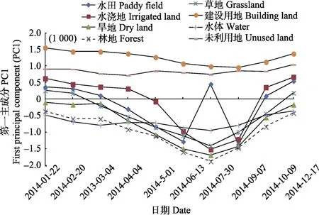
图4 各地类的PC1时间序列曲线Fig.4 PC1 time series curve of each land type
2.3 J-M距离可分离性分析及最佳时序HJ组合数据
地物类型可分性的判定方法很多,例如 J-M 距离、巴氏距离、欧氏距离、转换分离度、样本间平均距离等。相对于其他的地表特征可分性判定方法,J-M距离被认为是更优的指标[25]。J-M距离的取值范围是[0,2],0表示2种类别在某一特征上几乎完全混淆,2表示2种类别在某一特征上能够完全分开,其计算公式如下

式中B表示2种类别基于某一特征的巴氏距离,m1和m2表示2种类别的某特征均值,σ1和σ2表示2种类别的某特征标准差。
本研究结合长株潭土地利用现状图、研究区GF-1数据、Google Earth高分辨率影像,根据上式(1)和(2)对林地、水浇地、草地、水田的不同时相HJ数据组合进行J-M距离计算(表2)。
J-M距离结果表明,不同时间序列HJ数据组合的地物可分程度存在一定的差异,但 6个时相以上不同地物的可分性不再随 HJ时序数据组合数的增加而增大(图5)。为此,再结合NDVI与PC1时间序列曲线特征、不同植被类型的物候特征差异确定2月、5月、7月、9月、10月、12月6个时相的HJ-NDVI、HJ-PC1、HJ-PC2共18个波段作为研究区土地利用/覆盖信息提取的最佳时序数据组合。
2.4 面向对象的分类
2.4.1 影像分割
本研究利用eCognition提供的多尺度分割算法,对上文确定的最佳时序的HJ-NDVI、HJ-PC1、HJ-PC2组合数据进行分割。结合ESP(estimation of scale parameter)评价工具得到最优分割尺度的范围,并综合考虑各地物类型的分布特点,通过逐次调整分割尺度大小进行反复试验来确定最佳的分割尺度。确定的最佳尺度因子如下:分割尺度15,颜色因子0.8,形状因子0.2,平滑度0.5,紧凑度0.5,各波段的权重均设置为1。
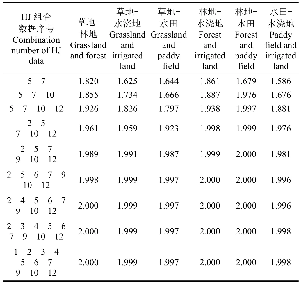
表2 不同时序HJ组合数据的4种典型地类间的J-M距离Table 2 J-M distance of four typical land types under different time series combination of HJ data
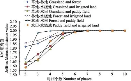
图5 不同时相组合数的4种地类间J-M距离值变化曲线Fig.5 J-M distance value varying curve of four land types with different phase combination number
2.4.2 土地利用/覆盖信息的提取分类及精度验证
以分割后的影像为基础,综合考虑影像对象的光谱特征(植被指数、各波段灰度平均值、亮度值、光谱最大差异、标准差)、几何特征(长宽比、边界长度、对象形状、紧密度)、纹理特征(同质性、反差)等构建分类规则,采用随机森林(random trees)算法对研究区土地利用/覆盖进行分类。随机森林算法是一种基于分类与回归决策树的组合算法[30-31],用随机的方式建立一个多决策树森林,能有效克服单一决策树中出现的欠拟合或过拟合的问题[32];随机森林中任意 2个决策树是相互独立的,对于新的测试样本,通过每棵决策树都对它进行分类决策,最后分类结果由投票法得出。该算法需要设置2个参数,生长树的数目N、节点处特征变量个数m。通过对不同参数设置进行分类对比分析,确定生长树的个数为100,特征变量个数为4时可得到满意的分类精度,同时又能节省分类耗时。
结合土地利用/覆盖分类标准、研究区的自然环境及地表分布特点,综合考虑研究区的整体性和遥感影像的可分性,构建以下土地利用/覆盖分类系统:水田、水浇地、旱地、林地、草地、建设用地、水体和未利用地 8种类别。本文利用混淆矩阵评价信息提取的总体精度、Kappa系数以及各地类的用户精度与生产者精度。
3 结果与分析
3.1 土地利用/覆盖分类结果与对比分析
利用最佳时间序列HJ组合数据,采用面向对象的随机森林分类算法(已下简称时间序列面向对象的分类),获得研究区土地利用/覆盖分类结果(图6)。将时间序列面向对象的分类结果(图6b)与研究区2014年10月GF-1影像(图 6a)进行对比与定性分析表明:分类结果与各地类的范围以及分布区域基本一致,斑点噪声较少。
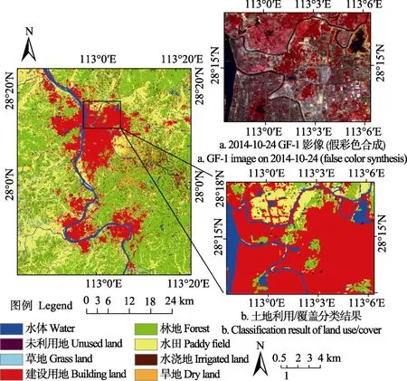
图6 最佳时序HJ数据面向对象的土地利用/覆盖分类结果Fig.6 Land use/cover classification result with optimal time series HJ data and object-oriented
为进一步探究该方法的有效性,将时间序列面向对象分类方法与时间序列基于像元分类方法的分类结果(图7a)以及单时相面向对象分类方法的结果(图7b)进行了对比分析。从目视效果上来看,时间序列基于像元分类方法的分类结果较为破碎,植被斑块存在较多的错分,“椒盐”现象较为明显;单时相面向对象分类方法提取的土地利用/覆盖信息准确性稍显不足,草地与水田之间的错分斑块较多,且对植被类型间的区分也不明显。
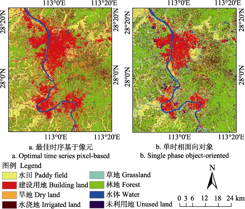
图7 最佳时序基于像元与单时相面向对象分类结果Fig.7 Classification result with optimal time series pixel-based and single phase object-oriented
3.2 分类精度评价与对比
结合 2013年长株潭土地利用现状图、Google Earth及部分实地考察数据,在研究区2014年10月24日GF-1高分辨率遥感影像上采集了验证样本数据,并采用混淆矩阵进行精度评价(表3)。
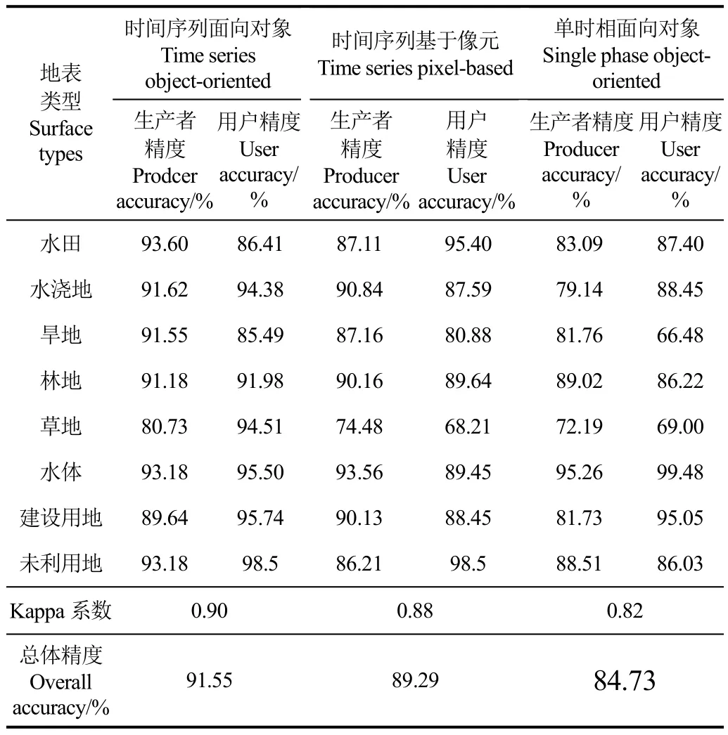
表3 不同土地利用/覆盖分类方法的精度评价Table 3 Accuracy evaluation of different land use/cover classification method
精度评价结果表明,时间序列面向对象分类方法的总体精度达到91.55%,Kappa系数为0.90,其中除草地外,主要的土地利用/覆盖类型的生产者精度均达到90%及以上,说明时间序列数据能够客观真实地反映植被生长的特征差异,能有效区分不同土地利用/覆盖类型。
通过对比分析,时间序列面向对象分类方法的总体精度和 Kappa系数较时间序列基于像元分类方法分别提高了2.26%和0.02,除水体与建设用地外,各种植被类型以及未利用地的生产者精度均得到不同程度的提高。时间序列面向对象分类方法的总体精度和 Kappa系数较单时相面向对象分类方法分别提高了6.82%和0.08,除水体外,各种地类的生产者精度均得到有效提高,尤其是植被类型与建设用地精度提高较为明显。分析表明面向对象方法可以有效地避免基于像元分类中由于异质性和光谱差异所产生的噪声,降低了“椒盐”现象的产生;而最佳时间序列组合数据可有效利用植被生长的物候期规律,有效地解决单期影像中植被类型间的光谱相似性,提高分类的精度。
4 结 论
1)本研究探讨基于时间序列 HJ组合数据,采用面向对象的随机森林算法提取城市区域土地利用/覆盖信息的方法,并对长株潭城市群核心区域2014年土地利用/覆盖信息进行提取,取得了较好的提取精度与准确度。总体分类精度和Kappa系数分别达到了91.55%和0.90,除草地外,主要的土地利用/覆盖类型的生产者精度均达到90%及以上。
2)通过与时间序列基于像元、单时相面向对象分类方法进行比较分析表明,本文提出的时间序列HJ组合数据的面向对象分类方法的总体分类精度、Kappa系数较前两者分别提高了2.26%、0.02和6.82%、0.08,有效消除了斑点噪声的影响,提高了信息提取的精度。
最佳时间序列 HJ组合数据可有效利用不同植被类型生长过程中的季节性光谱差异,避免单期影像中植被类型间的光谱相似性,有效提高了信息提取的精度。基于像元分类方法对“噪声”比较敏感,导致分类结果图斑较为破碎,在不考虑邻域像元的情况下往往会导致“椒盐”现象的产生,面向对象分类方法可以综合利用影像对象的光谱、几何、纹理等特征信息,充分挖掘邻域像元间的相关性,空间异质性小,有较强的抗噪能力,可有效地减弱像元光谱混淆现象。
[1] 林楠,姜琦刚,杨佳佳,等. 基于资源一号02C高分辨率数据的农业区土地利用分类[J]. 农业机械学报,2015,46(1):278-284.Lin Nan, Jiang Qigang, Yang Jiajia, et al. Classifications of agricultural land use based on high-spatial resolution ZY1-02C remote sensing images[J]. Transactions of the Chinese Society for Agricultural Machinery, 2015, 46(1): 278-284. (in Chinese with English abstract)
[2] 张猛,曾永年. 基于多时相 Landsat数据融合的洞庭湖区水稻面积提取[J]. 农业工程学报,2015,31(13):178-185.Zhang Meng, Zeng Yongnian. Mapping paddy fields of Dongting Lake area by fusing Landsat and MODIS data[J].Transactions of the Chinese Society of Agricultural Engineering (Transactions of the CSAE), 2015, 31(13): 178-185. (in Chinese with English abstract)
[3] 孙丹峰,杨冀红,刘顺喜. 高分辨率遥感卫星影像在土地利用分类及其变化监测的应用研究[J]. 农业工程学报,2002,18(2):160-164.Sun Danfeng, Yang Jihong, Liu Shunxi. Application of high-spatial IKONS remote sensing images in land use classification and change monitoring[J]. Transactions of the Chinese Society of Agricultural Engineering (Transactions of the CSAE), 2002, 18(2): 160-164. (in Chinese with English abstract)
[4] 徐永明,刘勇洪,魏鸣,等. 基于 MODIS数据的长江三角洲地区土地覆盖分类[J]. 地理学报,2007,62(6):640-648.Xu Yongming, Liu Yonghong, Wei Ming, et al. Land cover classification of the Yangtze River delta using MODIS data[J]. Acta Geographica Sinica, 2007, 62(6): 640-648. (in Chinese with English abstract)
[5] 郭琳,裴志远,吴全,等. 面向对象的土地利用/覆盖遥感分类方法与流程应用[J]. 农业工程学报,2010,26(7):194-198.Guo Lin, Pei Zhiyuan, Wu Quan, et al. Application of method and process of object-oriented land use/cover classification using remote sensing images[J]. Transactions of the Chinese Society of Agricultural Engineering (Transactions of the CSAE), 2010, 26(7): 194-198. (in Chinese with English abstract)
[6] 买凯乐,张文辉. 黄土丘陵沟壑区遥感影像信息面向对象分类方法提取[J]. 农业机械学报,2011,42(4):153-158.Mai Kaile, Zhang Wenhui. Object-oriented classification approach for remote sensing imagery information extraction in Loess Hilly-gully region[J]. Transactions of the Chinese Society for Agricultural Machinery, 2011, 42(4): 153-158.(in Chinese with English abstract)
[7] Yuan F, Sawaya K E, Loeffelholz B C, et al. Land cover classification and change analysis of the Twin Cities(Minnesota) Metropolitan Area by multi temporal Landsat remote sensing[J]. Remote Sensing of Environment, 2005,98(2/3): 317-328.
[8] 陈趁新,胡昌苗,霍连志,等. Landsat TM数据不同辐射校正方法对土地覆盖遥感分类的影响[J]. 遥感学报,2014,18(2):320-334.Chen Chenxin, Hu Changmiao, Huo Lianzhi, et al. Effect of different radiation correction methods of Landsat TM data on land-cover remote sensing classification[J]. Journal of Remote Sensing, 2014, 18(2): 320-334. (in Chinese with English abstract)
[9] 王敏,高新华,陈思宇,等. 基于Landsat 8遥感影像的土地利用分类研究:以四川省红原县安曲示范区为例[J]. 草业科学,2015,32(5):694-701.Wang Min, Gao Xinhua, Chen Siyu, et al. The land use classification based on Landsat 8 remote sensing image: A case study of Anqu demonstration community in Hongyuan County of Sichuan Province[J]. Pratacultural Science, 2015,32(5): 694-701. (in Chinese with English abstract)
[10] 郝鹏宇,牛铮,王力,等. 基于历史时序植被指数库的多源数据作物面积自动提取方法[J]. 农业工程学报,2012,28(23):123-131.Hao Pengyu, Niu Zheng, Wang Li, et al. Multi-source automatic crop pattern mapping based on historical vegetation index profiles[J]. Transactions of the Chinese Society of Agricultural Engineering (Transactions of the CSAE), 2012, 28(23): 123-131. (in Chinese with English abstract)
[11] 李鑫川,徐新刚,王纪华,等. 基于时间序列环境卫星影像的作物分类识别[J]. 农业工程学报,2013,29(2):169-176.Li Xinchuan, Xu Xingang, Wang Jihua, et al. Crop classification recognition based on time-series images from HJ satellite[J].Transactions of the Chinese Society of Agricultural Engineering (Transactions of the CSAE), 2013, 29(2): 169-176. (in Chinese with English abstract)
[12] 骆剑承,王钦敏,马江洪,等. 遥感图像最大似然分类方法的EM改进算法[J]. 测绘学报,2002,31(3):234-239.Luo Jiancheng, Wang Qinmin, Ma Jianghong, et al. The EM-based maximum likelihood classifier for remotely sensed data[J]. Acta Geodaetica et Cartographica Sinica, 2002, 31(3):234-239. (in Chinese with English abstract)
[13] 李彤,吴骅. 采用决策树分类技术对北京市土地覆盖现状进行研究[J]. 遥感技术与应用,2004,19(6): 485-487.Li Tong, Wu Hua. Application of decision tree classification to Peking land cover[J]. Remote Sensing Technology and Application, 2004, 19(6): 485-487. (in Chinese with English abstract)
[14] 温兴平,胡光道,杨晓峰. 基于 C5.0决策树分类算法的ETM+影像信息提取[J]. 地理与地理信息科学,2007,23(6):26-29.Wen Xingping, Hu Guangdao, Yang Xiaofeng. Extracting information from ETM+ image using C5.0 decision tree algoritm[J]. Geography and Geo-information Science, 2007,23(6): 26-29. (in Chinese with English abstract)
[15] Kobayashi S, Sanga Ngoie K. A comparative study of radiometric correction methods for optical remote sensing imagery: the IRC vs. other image-based C-correction methods[J]. International Journal of Remote Sensing, 2009,30(2): 285-314.
[16] 常春艳,赵庚星,王凌,等. 滨海光谱混淆区面向对象的土地利用遥感分类[J]. 农业工程学报,2012,28(5):226-231.Chang Chunyan, Zhao Gengxing, Wang Ling, et al. Land use classification based on RS object-oriented method in coastal spectral confusion region[J]. Transactions of the Chinese Society of Agricultural Engineering (Transactions of the CSAE), 2012, 28(5): 226-231. (in Chinese with English abstract)
[17] 牟凤云,罗丹,官冬杰,等. 面向对象的土地覆盖信息提取方法研究及应用[J]. 重庆交通大学学报(自然科学版),2014,33(6):104-108.Mu Fengyun, Luo Dan, Guan Dongjie, et al. Research on object-oriented land cover information extraction[J]. Journal of Chongqing Jiaotong University (Natural Science), 2014,33(6): 104-108. (in Chinese with English abstract)
[18] 许伟,奚砚涛. 基于Landsat 8遥感影像的合肥市土地利用分类[J]. 湖北农业科学,2015,54(15):3625-3629.Xu Wei, Xi Yantao. Research on land use classification in Hefei based on landsat 8 images[J]. Hubei Agricultural Sciences,2015, 54(15): 3625-3629. (in Chinese with English abstract)
[19] 李恒凯,吴立新,李发帅. 面向土地利用分类的HJ-1 CCD影像最佳分形波段选择[J]. 遥感学报,2013,17(6):1572-1586.Li Hengkai, Wu Lixin, Li Fashuai. Optimal fractal band selection on HJ-1 CCD image for land use classification[J].Journal of Remote Sensing, 2013, 17(6): 1572-1586. (in Chinese with English abstract)
[20] 于文婧,刘晓娜,孙丹峰,等. 基于HJ-CCD数据和决策树法的干旱半干旱灌区土地利用分类[J]. 农业工程学报,2016,32(2):212-219.Yu Wenjing, Liu Xiaona, Sun Danfeng, et al. Land use classification in arid and semi-arid irrigated area based on HJ-CCD data and decision tree method[J]. Transactions of the Chinese Society of Agricultural Engineering (Transactions of the CSAE), 2016, 32(2): 212-219. (in Chinese with English abstract)
[21] 仲波,马鹏,聂爱华,等.基于时间序列HJ-1/CCD数据的土地覆盖分类方法[J]. 中国科学:地球科学,2014,44(5):967-977.Zhong Bo, Ma Peng, Nie Aihua, et al. Land cover mapping using time series HJ-1/CCD data[J]. Science China: Earth Sciences,2014, 44(5): 967-977. (in Chinese with English abstract)
[22] 杨浩,黄文江,王纪华,等. 基于HJ-1A/1B CCD时间序列影像的水稻生育期监测[J]. 农业工程学报,2011,27(4):219-224.Yang Hao, Huang Wenjiang, Wang Jihua, et al. Monitoring rice growth stages based on time series HJ-1A/1B CCD images[J]. Transactions of the Chinese Society of Agricultural Engineering (Transactions of the CSAE), 2011, 27(4): 219-224. (in Chinese with English abstract)
[23] 刘佳,王利民,杨福刚,等. 基于 HJ时间序列数据的农作物种植面积估算[J]. 农业工程学报,2015,31(3):199-206.Liu Jia, Wang Limin, Yang Fugang, et al. Remote sensing estimation of crop planting area based on HJ time-series images[J]. Transactions of the Chinese Society of Agricultural Engineering (Transactions of the CSAE), 2015, 31(3): 199-206. (in Chinese with English abstract)
[24] 孙俊杰,马大喜,任春颖,等. 基于多时相环境卫星数据的南瓮河流域湿地信息提取方法研究[J]. 湿地科学,2013,11(1):60-67.Sun Junjie, Ma Daxi, Ren Chunying, et al. Method of extraction of wetlands information in Nanweng River basin based on multi-temporal environment satellite images[J].Wetland Science, 2013, 11(1): 60-67. (in Chinese with English abstract)
[25] Sun Zhongping, Shen Wenming, Wei Bin, et al. Objectoriented land cover classification using HJ-1 remote sensing imagery[J]. Science China Earth Sciences. 2010, 53(Supp. I):34-44.
[26] 贾明明,宗明,张柏,等. 综合环境卫星与 MODIS数据的面向对象土地覆盖分类方法[J]. 武汉大学学报•信息科学版,2014,39(3):305-310.Jia Mingming, Zong Ming, Zhang Bai, et al. Land cover classification of compositing HJ-1 and MODIS data base on object-based method[J]. Geomatics and Information Science of Wuhan University, 2014, 39(3): 305-310. (in Chinese with English abstract)
[27] 陈云浩,冯通,史培军,等. 基于面向对象和规则的遥感影像分类研究[J]. 武汉大学学报•信息科学版,2006,31(4):316-320.Chen Yunhao, Feng Tong, Shi Peijun, et al. Classification of remote sensing image based on object-oriented and class rules[J]. Geomatics and Information Science of Wuhan University, 2006, 31(4): 316-320. (in Chinese with English abstract)
[28] 苏伟,李京,陈云浩,等. 基于多尺度影像分割的面向对象城市土地覆被分类研究:以马来西亚吉隆坡市城市中心区为例[J]. 遥感学报,2007,11(4):521-530.Su Wei, Li Jing, Chen Yunhao, et al. Object-oriented urban land-cover classification of multi-scale image segmentation method: A case study in Kuala Lumpur City Center,Malaysia[J]. Journal of Remote Sensing, 2007, 11(4): 521-530. (in Chinese with English abstract)
[29] Robertson L D, King D J. Comparion of pixel-and objectbased classification in land-cover change mapping[J]. International Journal of Remote Sensing, 2011, 32(1): 1505-1529.
[30] Hao Pengyu, Wang Li, Niu Zheng, et al. The potential of time series merged from Landsat-5 TM and HJ-1 CCD for crop classification: A case study for Bole and Manas counties in XinJiang, China[J]. Remote Sensing, 2014, 6(8): 7610-7631.
[31] Breiman L. Random forest[J]. Machine Learning, 2001, 45(1):5-32
[32] 李治,杨晓梅,孟樊,等. 物候特征辅助下的随机森林宏观尺度土地覆盖分类方法研究[J]. 遥感信息,2013,28(6):48-55.Li Zhi, Yang Xiaomei, Meng Fan, et al. LULC classification based on random forest with the aid of phenological features[J]. Remote Sensing Information, 2013, 28(6): 48-55. (in Chinese with English abstract)
Extract of land use/cover information based on HJ satellites data and object-oriented classification
Zhu Yongsen, Zeng Yongnian※, Zhang Meng
(1.School of Geosciences and Info-physics, Central South University, Changsha410083,China;2.Center for Geomatics and Regional Sustainable Development Research, Central South University, Changsha410083,China)
Land use/cover information is the basis for the study of regional climate and environment, and the information security of land resources planning and management. However, the accuracy of urban areas land use/cover information extraction is significantly affected by the high heterogeneity of land surface. Remote sensing technology, providing large-scale,timely, continuous and comprehensive measurements, has become an important means of land use/cover information extraction. HJ satellites, with high temporal and spatial resolution and wide coverage, provide a new way to fast and accurately extract large-scale land use/cover information. They have been widely used in land use/cover classification, crop information extraction, wetlands information extraction, and so on. The object-oriented classification method, which makes full use of the spectral information of remote sensing images and takes into account the spatial distribution characteristics and correlations of geographical objects, can compensate for the deficiency of traditional pixel-based classification methods. This study developed a supervised classification method for regional land use based on the object-oriented random trees algorithm to quickly extract land surface information with low cost and high precision. We selected the Changsha-Zhuzhou-Xiangtan core area as the study area and used the multi-temporal and multi-spectral information of HJ satellite CCD (charge-coupled device) data. Firstly, high quality HJ-CCD data (10 phases in total) were selected, and preprocessed by radiometric calibration, atmospheric correction,accurate geometric correction and image registration. The time series of normalized difference vegetation index (NDVI) and of the first principal component (PC1) were calculated, and their results overlapped each other. The best time series of HJ classification data were determined by the J-M (Jeffries-Matusita) distance variable separability analysis, combined with land cover of study area, and phenotypic characteristics difference of different vegetation. HJ data of the February, May, July,September, October and December phases are the best data combinations for land use/over information extraction in this study.Then the e-Cognition’s multi-scale segmentation algorithm was employed to segment the HJ-NDVI, HJ-PC1, HJ-PC2 (the second principal component) of the best time series combination. The urban land use/cover information was classified by the object-oriented random forest algorithm. Finally, the accuracy of the algorithm was evaluated, and compared with that of the time series pixel-based classification and single-phase object-oriented classification. The results indicate that the land use/cover information extracted by the object-oriented classification method using time series HJ data is consistent with the real situation on range and distribution of each land type, and with less speckle noise. The overall accuracy and Kappa coefficient of this method are 91.55% and 0.90 respectively. Specifically, the accuracy is higher than 90% for the paddy field,irrigated land, dry land and forest, and is close to 90% for building land. Compared with the time-series pixel-based classification and single-phase object-oriented classification methods, the overall classification accuracy and Kappa coefficient of the proposed method are increased by 2.26%, 0.02 and 6.82%, 0.08 respectively. This means the best time series HJ combination data can fully utilize the seasonal spectral differences of different vegetation types, which avoid the spectral similarity among different vegetations in single-phase image. So the proposed method can effectively improve the accuracy of land use/cover information extraction in urban areas.
land use; remote sensing; classification; time series; object-oriented; land use/cover classification; urban areas; HJ satellites
10.11975/j.issn.1002-6819.2017.14.035
TP79; S127
A
1002-6819(2017)-14-0258-08
朱永森,曾永年,张 猛. 基于HJ卫星数据与面向对象分类的土地利用/覆盖信息提取[J]. 农业工程学报,2017,33(14):258-265.
10.11975/j.issn.1002-6819.2017.14.035 http://www.tcsae.org
Zhu Yongsen, Zeng Yongnian, Zhang Meng. Extract of land use/cover information based on HJ satellites data and object-oriented classification[J]. Transactions of the Chinese Society of Agricultural Engineering (Transactions of the CSAE), 2017, 33(14): 258-265. (in Chinese with English abstract) doi:10.11975/j.issn.1002-6819.2017.14.035 http://www.tcsae.org
2017-01-19
2017-07-05
国家自然科学基金项目(41171326, 40771198);中南大学中央高校基本科研业务费专项资金(2017zzts775)
朱永森,男,河南驻马店人,研究方向为遥感技术及应用。长沙中南大学地球科学与信息物理学院,410083。Email:yongsenzhu@sina.com
※通信作者:曾永年,男,青海西宁人,教授,研究方向为遥感与地理信息系统及其环境变化研究。长沙 中南大学地球科学与信息物理学院,410083。
Email:ynzeng@mail.csu.edu.cn
