毒性国度/塔溪矿区的未来
——美国俄克拉荷马州渥太华县皮歇尔与卡丁矿区的案例研究
2017-11-01尼尔柯克伍德李佳怿王晞月
著:(美)尼尔·柯克伍德 译:李佳怿 校:王晞月
毒性国度/塔溪矿区的未来
——美国俄克拉荷马州渥太华县皮歇尔与卡丁矿区的案例研究
著:(美)尼尔·柯克伍德 译:李佳怿 校:王晞月
从社区层面探讨了40平方英里(约103km2)的塔溪矿区“超基金”污染场地(Superfund Site)的可持续规划设计以及应用策略。位于俄克拉荷马州渥太华县的塔溪矿区的状况表明联邦和州立管理机构在应对该地区长期以来的环境退化、有毒物质侵害以及环境公平问题上并没有取得明显成效。因此,附近的社区邻里、环境部门官员与学术团体积极合作,针对采矿遗留的大规模土堆、污染的河道、沉降的地面和塌陷的坑井等进行了长期的修复、再生和规划的探索。这个案例研究将证明,这种基于地方的矿区更新模式可以作为一个框架将社区诉求、环境整治和景观再生整合到一起。
采矿区;后工业景观;超基金;景观改造;废弃地
前言
位于俄克拉荷马州渥太华县的塔溪矿区曾经是个铅矿区,也是俄克拉荷马州、堪萨斯州和密苏里州三州矿区的组成部分。塔溪矿区曾经的规划发展表明,在应对长达数10年的环境退化、有毒物质侵害和环境公平等一系列问题上,多级政府的管理没有取得理想成效。因此,附近的社区、环境部门的官员开始与地方机构和学术团体合作,针对采矿遗留的大规模土堆、污染的河道、沉降的地面和塌陷的坑井等典型的“超基金”场地进行了长期的修复再生和规划探索(图1)。
这里将塔溪矿区“超基金”场地的项目作为一个案例进行研究,以呈现一种整合当地居民、利益相关者、环境组织以及学术科研机构的景观规划设计策略。我认为基于地方的场地转变方式与“自上而下”的机制相反,它作为一个综合框架,具有整合社会诉求、应对环境治理以及逐步实现污染土地景观再生的潜力。
本文也建议采用一种全面审视矿区的方法,这种方法承认并作用于一种需求,即在当地社会、文化和生态环境中以渐进方式应对土地再利用及变化。它对目前那些单纯依据现行法律处理此类场地的策略提出了挑战,着重关注场地所呈现的诸如历史、生态、社区和未来潜力等景观复杂性。它描述场地内的自然状况、人工构筑、物质特性以及一些常规而简便的减轻目前环境退化和污染的方式。到最后,我们仍然需要向诸如塔溪矿区的当地居民寻求引导,是他们在为自己的日常和未来使用塑造、恢复和改造着这里的景观。
文化评论员约翰 伯杰的观点如下[1],并且可以应用于当代环境下的许多采矿区:
景观是可以具有欺骗性的——有时候在居民的眼里,景观对生活的影响远不如窗帘一样的生活物品,尽管他们在这里奋斗、取得成就或发生意外。
作为局外人,当我们考量一个景观是否已经受到污染时应十分慎重,应充分了解它的区位并关注当地居民。这对于那些代表联邦、州、地方机构和市政机构处理严重环境问题的工作人员来说尤其如此。这项工作的重点是矿山废弃地的修复。在这里,大地、水和土壤的修复对社区和利益相关者而言,成为了可持续的基础设施投资项目,对它们的修复不仅仅是选择一种合适的环境技术那么简单。尽管从20世纪80年代起俄克拉荷马州东北部塔溪矿区的修复工作就受到人们关注,但其仍然处于修复与规划的早期阶段。如今这些工作成为了应对采矿区问题的一个实用模型。
2组照片
南希 戈尔登贝格在俄克拉荷马州渥太华县塔溪矿区长大并完成小学学业。她经常从她的工作地芝加哥回到这里。作为一名专业的摄影师,她用照片记录了她家乡的景观。得益于当地轻型飞机的租赁业务,她以广景视角记录了塔溪废弃矿区内的社区、商业区、道路、房屋和她毕业的小学。这些废弃地上散布着橙红色的污水沟、河流和池塘,遍布着许多塌陷的坑洞(图2)。

1 塔溪矿区的景观与周围废弃土地,LEAD成员Rebecca Jim在调查废料堆Tar Creek’s landscape and surrounding waste territories,Rebecca Jim of LEAD surveys a chat pile

2 俄克拉荷马州渥太华县坍塌的灰岩坑Collapsed sinkholes, Ottawa County, Oklahoma
5个矿业城镇与社区的房屋、学校、商店及其居民散布其中。
南希开车沿着外围道路行驶,在绿树成荫的河床旁边伫立,在改造的土堆附近散步,望着质朴的大地上散落着孩子们玩耍的秋千和沙箱。南希用她的相机拍摄了操场、球场、停车场,以及皮歇尔、卡丁、夸堡、科默斯、北迈阿密5个矿业城镇的街道照片(图3)。

3 院子里散落的儿童秋千和沙箱Modest yards littered with children’s swings and sandboxes
项目通过2个不同的视角看待塔溪矿区:其一是大片后工业背景下的采矿废弃地。结合美国地质勘探局的地图、卫星影像、GPS坐标、生产统计数据和历史地图对这个区域进行分析,识别叠加在这片区域上面的小型住宅群、道路和社区等(图4);近期则通过儿童和青少年的医疗数据、重金属辐射程度和修复报告等其进行分析。

4 社区的日常生活——学校、工作、娱乐The daily life of communities—school, work, recreation
另一个视角是在相对较小尺度上的,聚焦于社区居民的日常生活细节。正如图4所展示的那样——学校、工作、菜园、集会、娱乐、礼拜活动、健康中心、棒球联赛等是矿区中常见的日常活动。当然,试图以这个视角来描述三州矿区中这块地区的环境问题大小是有难度的。
从这些照片中可以看到塔溪矿区的酸性水体和大量的采矿废弃遗留物,塌方、坑洞、淹井等区域。然而,就像温尔德 贝瑞所述,“无论是道路还是建筑,在这些图片中都有一些很容易被辨别出来的东西,如果连这些都无法识别,那么就没有什么可以看清的东西了。而这些容易识别的元素体现出了较强的特殊性(图5),即它们都是人类活动的方式、产品或成果”[2]。而区域的转变和复兴同样也需要当地人来复兴土地、恢复社区活力。当今,修复并再利用被污染土地的成功案例已并不少见,但鲜有项目能很好地诠释这样的修复如何为社区、基础设施及开放空间的建设带来影响。振兴和恢复社区的活力需要从多个视角切入,需采取多种方法来应对当地社区发展和场地设计遇到的细节问题。诸如塔溪矿区场地为人们看待景观以及理解大规模的污染场地提供了3种可能的模型。

5 塔溪矿区的红橙色酸性水体The red-orange acidic waters of Tar Creek
规划的3个模型
第一类模型只是描述性的,将其视为曾经开展工业活动的遗留场地——这些工业活动遗留的元素包括塔溪矿区的废料堆和废弃矿井等。
第二类模型将其视为在“场地技术环境”下工程与设计相结合的实践。场地中退化的物质环境被真正地“塑造”或“重建”,即土壤、水体和地貌通过科学和建筑工程的技术手段被重塑。这是区域重建的常用方法之一,构思和建设都是有组织地进行实施的。
第三类模型对规划师、设计师以及社区和环境组织都是最重要的,它突破了传统的场地规划设计方式。在传统模型下人们通过固有的自然属性认识“绿地”或无污染的土地,这些自然属性包括地质、土壤、植被、小气候和野生动物等信息。这些传统分析模式对认识当代的污染场地帮助有限,尤其是在塔溪矿区这类土地面貌被彻底改变过的地区。第三类模型为污染的场地提供了一种新的思路,即无论是否已受到干预或污染,都将这些地方的真实物质环境状况理解为场地的初始状态。
在接下来的几十年,政府将继续每年为清理塔溪矿区这样的废弃地提供相关资源,清理其中的危险物质和有毒材料。然而这些行动也带来了一些问题:
• 在超基金场地内外,这些大尺度的场地将如何塑造国土景观和我们未来的社区、城镇和区域。
• 这些场地如何满足我们对科学、文化和审美不断变化的需求?
• 在21世纪,诸如废弃矿区、荒凉平原和有毒河流等场地的这种景观适应性将如何影响今后公众对自然及人造环境的互动关系?
通过探讨场地可持续的规划设计方案及社区层面的发展策略,为塔溪矿区40平方英里“超基金”场地的长期修复及发展提出设想。强调该区域的生态问题并解释了为什么这里被认为是“弹性”的。虽然塔溪矿区的规划引导人们探索土地未来规划和修复的方法,但是这块区域如今的生态状况表明许多相关机构在应对长达数10年的环境恶化、土壤毒物侵害等一系列问题上没有取得显著成效。我不认为造成失败的原因是这些机构使用了错误的方法或是管理上出现了疏忽,相反,我认为还存在其他能够更好解决这类问题的模型,能以更全面的方式展现景观的真实情况,包括景观的污染情况以及当地环境和社区的优势和诉求。
当地社区、环境官员机构工作人员与调查小组联合展开了对挖掘土堆、河道污染、地面沉降和采矿区沉陷等问题长期的修复和再利用计划。例如,凭借参议员詹姆斯 英霍夫的资金担保,美国陆军工程兵部队采取相关的措施以应对危险的开放矿井,减轻修复计划在实施过程中对当地居民产生的危害;领导多个团队的专家来评估人口密集地区和主要交通走廊地面沉降的风险。这个项目的合作伙伴有美国陆军工程兵部队、美国国家环保局、美国内政部、俄克拉荷马州和部落政府。2003年5月,他们在詹姆斯 英霍夫的组织下签署了一份协议,提出针对人类健康和塔溪矿区环境威胁的解决方案。由此出台了“塔溪和低春江流域管理计划”,这是对塔溪矿区复杂环境问题的一个多学科指导方案。
然而我认为,虽然“塔溪和低春江流域管理计划”中的方法促进了场地转型,但是仍需要其他更加长期的策略框架以统一社会诉求、解决环境善后和景观再生的问题。这种对于当地长期问题的诉求意味着单纯土地面貌的改变或废弃地生产使用价值的恢复是不够的,而是需要社会内部针对这片被污染的土地开展深刻的变革。
首先,应清晰地梳理关于塔溪矿区一些基本信息、其现状的和未来的可能性。
塔溪矿区“超基金”场地的环境
塔溪矿区曾是三州矿区的一部分,面积超过700平方英里(约1 813km2),包括俄克拉荷马州东北部地区、堪萨斯州东南部地区,直到密苏里州西南部的杰斯帕县、牛顿县和麦克唐纳县。占地25 400英亩40平方英里(约103km2)的塔溪研究区域位于俄克拉荷马州东北角渥太华县的老皮歇尔铅锌矿区废弃矿山隧道以北300英里(约482.80m)。这40平方英里的区域内有5个城镇(包括皮歇尔和卡丁)和200多个以前的采矿作业点和铣削工厂。
那时,乳白色的采矿废物堆积成山,骄傲地昭示着皮歇尔是美国采矿业的中心(图6)。“二战”结束后,金属的需求量下降,到了20世纪60年代,矿业作业逐渐放缓,最后在20世纪70年代初停止,采矿企业离开了这个区域,作业泵也停止了工作。
在采矿作业停止后,作业泵被关闭,这些矿区也逐渐被水填满。黄铁矿散布在矿区内的废弃物堆中、闸室的四壁上,与不断上升的水体发生化学反应,形成酸性水,以及共计100亿加仑(约0.38亿m3)毒性地下水,这些水逐渐涌上地表,使酸性水的排水管道也逐渐被染上了橙色。1978年,美国地质调查局的报告称,这些矿区包含10万英亩尺(约12 334.82万m3)的水。其中的33 000英亩尺(约4 070.49万m3)的水都是酸性的,这意味着总计10 753 097 000加仑(约4 070.49万m3)的酸性水将被排入塔溪矿区。这些水又将从塔溪矿区涌入尼欧肖河中。

6 成堆的乳白色矿业废料Mountains of milky-white mine waste
美国国家环保局在1981年将塔溪矿区的整治加入了全国首要工作清单,耗资超过4 000万美元来解决其中最严重的水体、土壤和空气污染问题,全部清理活动预计将花费5亿美元。粉尘大小的尾矿砂中含有重金属,尤其是铅和镉,对6岁以下儿童的健康造成了严重的威胁。暴露于铅和锌之中会引起神经系统疾病和肾脏的损伤,导致学习障碍、注意力缺乏症或智力下降。俄克拉荷马州卫生部1999年的一项健康研究显示,皮歇尔地区38.3%的儿童和卡丁地区62.5%的儿童的血铅含量增加了10ug/dL,其他非矿业地区血铅超标的儿童比例则低于2.4%。而美国普遍的大众期望值是4.4%。尽管70%的研究区域都是部落地区,42.5%的人口都是印第安人,但是受到风险的儿童比率与种族无关。
当地居民对污染的恐惧已经逐渐趋于平和坦然的接受。有毒废弃物的存在为未来的规划建设设置了目标。在此,场地修复目的不是为了恢复到最原始的自然状态,也不是为了消除人们对场地的负面评价,而其关键是恢复景观和社区发展所依赖的生态基础。巨大的政治和社会力量威胁到了塔溪矿区的一些地方,而其他地方又似乎完全没有受到这些当代问题的影响,过去的一些活动被完整地续存下来。这些都应该得到我们的关注,因为它们和成千上万大大小小的场地一样,对未来人类空间的多样性、社区和自然生活的可能性至关重要。幸存下来的城镇和社区被疾病问题(尤其是新生儿和儿童的疾病)、就业问题和当地景观大范围的污染问题所困扰。然而即使面对所有这一切困难,这些地方仍然保留着深厚的文化和地域特征,在其节日、艺术和文学作品中都充分描绘了土地、居民、动植物之间密切的精神联系。
下一节将讨论联邦政府对住宅区和社区设施周围的土壤问题的响应。
美国国家环保局的响应——土壤清理
在1979年,美国国家环保局和俄克拉荷马州开始关注酸性水体和土壤污染,包括地表和地下水。俄克拉荷马州州长在1980年成立了塔溪矿区专案小组,来调查矿区酸性水的排放。该场地在1981年被提议加入全国首要工作清单中,并在1983年正式加入该列表。到1984年6月,对人体健康的潜在严重风险评估制度被建立起来,在超基金法案的推动下,签订了关于此的决议备忘录。14年后即在1998年,美国国家环保局六区应急小组实施了住区土壤样本检测项目。土壤检测结果表明,65%的住宅庭院中铅浓度>500ppm。表1数据来自美国国家环保局,表明了2000年初“超基金”研究场地——塔溪矿区的5座城镇(皮歇尔、卡丁、夸堡、北迈阿密、科默斯)的土地分类状况(表1)。
住宅区修复行动自1996年启动,首先针对那些有孩子的家庭和土壤铅浓度超过1 500ppm的区域(表2)。地表下的土壤以6英寸(约15.24cm)为单位被一层层地逐步去除(图7),直到移除深度达18英寸(约45.72cm)或是到铅浓度<500ppm的土层为止。取而代之的是干净的土壤和灌木,灌木在更换土壤时被清理掉,在换土结束后又重新被栽植起来。新种植的草坪如图8所示。
据2005年4月的报道,联邦机构这一计划已使当地获益:
“从5座城市矿区的2 071个住宅庭院和使用频率高的公共区域清理铅含量超标的土壤,大大减少了人群与铅的接触,特别是幼儿。近期研究比较了1997年和2000年人们的血铅水平,结果显示皮歇尔和卡丁地区1~5岁的儿童血铅水平下降了约50%,已经达到或低于疾控中心所设定的10ug/dL 。有害物和疾病登记机构在2004年发布的一份报告显示,塔溪矿区血铅浓度超过10ug/dL的儿童比例从1996年的31.2%下降到2003年的2.8%。这一成就归功于住宅区的土壤清理行动和各级政府开展的教育活动。废弃矿井的封堵工作也降低了布恩含水层中有毒物质转移到饮用水中的风险。[3]”

表1 城镇土地性质分类(2000年2月)Tab. 1 Property categories by town, Feb. 2000

表2 庭院补救行动(2000年3月)Tab. 2 Yard remedial action status, March 2000

7 15cm(6英寸)的土壤清除层Soil removal in 15cm (6”) layers

8 以洁净土壤和新草坪替代原有的污染土壤Clean soil is replaced along with new grass
塔溪矿区夸堡部落的前环境负责人厄尔 哈特利指出,由于堆积的废弃矿石上方将不断有风吹过,因此2年之后,这里将会被再次污染,甚至比原来更严重。没有进一步的监测可以证实或反驳这一理论,但是,这些矿石粒子在风力作用下会继续扩散,很可能形成一个微粒层。此外,在某些情况下,“清洁的土壤”将意味着形成不透水的黏土,清除修复工作使新庭院中都是透水性差的黏土,雨水使房屋湿气严重,霉菌以惊人的速度繁殖,致使该地区很多人得了哮喘病。
回归文本的讨论重点,即对比常被州和联邦机构用来处理如塔溪矿区这类地区污染问题的传统方法(模型1和模型2)和基于地方环境条件,不论它们是否被干预和污染,而发展的另一种替代模式(模式3)。这个模式适用于大型复杂场地的长期清理和再生,需要与利益相关者和社区密切合作。这2种方法完全不同。一方面,当前用于工程分析、评价和反馈的常规方法(模型1和模型2)只是片面地关注了场地的污染状况。总的来说,这些场地是不断演替和发展的,污染物在一个时间框架内可以被测量、评估和移除,此后,这些地方又将变得干净,没有任何污染,拥有自然原始的风景,大地与人们和谐相处。在另一方面,这个方案看似已经解决了最紧迫的问题,即社区居民铅中毒的健康问题,尤其是儿童和老年人。移除地表下18英寸(约45.72cm)的土层换上干净的土壤直接消除铅的来源,这一方法可立即取得成效。这个方法可以被量化、测量和成图,因此在塔溪矿区的修复中,在经济和工程方面都付出了巨大的努力。虽然这种方法可以用较短的时间解决污染问题,但是它却规避了真正的问题,简单地说这些场地可以理解为长时间不间断的工业进程(采矿)的产物。矿业作业的残留物和废弃物逐渐改变了生态系统、水文系统和土壤沉积物的结构。同时还导致植被、野生动物和水生生物系统也发生了巨大的变化。最后这些土壤和水的改变也对人类产生了影响,即使住宅区采取了更换土壤的措施,这些影响仍然是持续不断的。100年来的采矿活动对土地的大规模影响是不可能马上消除的,修复的进程也不可能是一次性的活动。它需要一个更适合的模型来迎合不断变化的污染修复技术,应转向与社区和当地利益相关者的合作中,使他们参与到土地修复中来,而不是被动地旁观。
这里涉及了模型1和模型2在应对塔溪矿区更深层和更严重的问题时的局限性。大尺度的环境问题如废弃物堆、水体污染、地面沉降和空气污染等需要更长久的应对方案。塔溪矿区的规划和修复需要一个不同于以往的方式,一个更适宜场地实际情况的方式,这些情况既包括自然方面也包括文化方面,同时希望利益相关者和社区都参与其中。大规模、长期的修复需要对当地情况的充分认知,同时每个阶段大规模的设计构想需要通过若干个小而重要的过程来实现。一些大规模的修复工作带来的挑战是巨大而长期的,随时间变化的自然景观、原始环境和修复进程的连续监测、文化和环境的大量图像是关注的重点,也是人们理解这块场地的关键。
与美国国家环保局的治理方案(于1997年3月提出的替代模型2计划,)相反的是,哈佛团队随后开展的研究项目的一部分验证了厄尔 哈特利假设中关于污染的长期性与污染程度的主要观点,即以社区为基础的规划模型可以更有效地解决“超基金”场地土壤铅浓度超标的问题。基于这一理论,我们正在探索结合场地情况的土地修复的长期方案。
哈佛大学基于社区保护与干预的研究项目
塔溪矿区调研项目近期正在进行中,这个项目将哈佛大学医学院、公共卫生学院、设计学院3个研究生院的教师和研究人员的成果进行整合。各小组委员会也由此建立了联系,这些小组委员会成员包括医学院的霍华德 胡博士、科学中心的卢西亚 拉温格博士、哈佛公共卫生学院的杰克 斯宾格勒教授、波士顿布里格姆女子医院的罗伯特 莱特博士、设计学院的代表、L.E.A.D组织(俄克拉荷马州的当地社区团体)的丽贝卡 吉姆。
哈佛大学基于社区的保护与干预研究项目有3个重要的组成部分。第一,对铅元素进行生物标记的研究,它以社区为基础且针对儿童。第二,从泄漏点到人体铅元素位置的追踪研究,包括对居民种植采摘以及野生动物的研究。第三,未来该项目将使用创新性的修复手段和方法,达到使铅元素大规模减少的目的。由此项目开发出一个模型,它将其他相关要素结合起来应用在环境污染修复中,例如设立湿地处理系统试点区、湿地野生动物保护区以解决地面沉降、洪水、矿区水排放和采矿废弃物成堆等问题。例如,结合植物修复的新兴技术尝试使用生态种植策略来修复污染场地,可以长期地对更大范围的土壤和水体进行修复。因此,模型3引导我们转向一种适应性场地管理的方法,将以当地情况为基础的策略与长期土地修复相结合的方案来应对塔溪矿区21世纪上半叶的长期发展。
基于社区的创新性修复
哈佛大学项目一个重要的方面是使用了本地化的修复策略——植物修复技术,与其他措施一同介入,并由当地社区完成植物种植、监测和收割的工作,这一过程需要以一种普适性的方式开展,其更类似于农业实践而非工程修复措施。社区和当地利益相关者已持续开展这项工作,多年来植物修复系统的演替不仅清理了部分污染物,也建立了一个新的植物生态系统,植物覆盖在废矿堆上,以有机而整体的方式清理湿地和居民区的污染物。这一进程时间轴显示了30多年以来的每一项短期工作结果,每个阶段通常为一年或三个生长季。
根据植物从土壤和地下水中吸收铅元素能力的研究结果,植物修复(字面意思是植物清理)被看做是一种低成本的处理铅污染的技术。这是一个使用植物进行修复的低成本在地技术,使用的植物包括乔木、草本植物和水生植物,隔离和吸收自然环境中的有毒物质。这一技术在处理污染场地上几乎是通用的。
植物(超富集植物)本身具有累积大量金属元素的能力,例如铅,这一观点在1948年被提出。欧洲早期的探索性研究主要关注的是“二战”后重建工作中对矿业次品和废料的重复利用。然而这项研究直到20世纪80年代中期才在美国开展,此时,植物修复技术的原理正在实验室进行试验。依据污染物的处理方式,这些研究可以被分为3大类:累积、降解和液压控制。优化了植物修复技术后,在土壤污染区,植物紧密成行地垂直于地下水流向进行种植 ,或者是成斑块状、团状种植。此技术被应用在含铅量过高的社区,包括运动场、沿河步道和公园等。这种技术聚焦于将基于社区的植物修复模型与其他社区问题进行整合,并开展长期的工作。
一只手镯不叮当
丽贝卡 吉姆经常引用一句古老的谚语“一只手镯不叮当”[4]。植物修复研究项目本身就是寻求不同学科领域和不同行业之间的合作。将植物修复技术与其他形式的环境规划设计相结合是极具潜力的,例如结合湿地处理系统、绿道和太阳能技术。植物修复技术对铅元素的处理在许多大规模的示范项目中,是处理危险废弃地的一套成熟的方案,可以代替一些其他处理方式,例如代替塔溪矿区的土壤移除。植物修复技术与传统技术的差异在于它耗时过长,具有生物系统固有的局限性,因此限制其在传统场地上应用。它的成本低(比传统修复技术低70~100倍),适合应用在像塔溪矿区一样需要长期修复的场地,且植物修复技术的应用在此有潜力结合其他社区再开发项目来开展。
对植物修复技术的检测始于1999年夏天,由研究生马克里 博温格执行。成年人、大学生和高中生都参与了整个研究阶段,他们对外来植被和原生植被在场地内的增长模式进行调查。从而未来的设计将针对不同区域的情况,结合植物修复与社区参与策略,对河流走廊、矿业废弃物聚集点、住宅区和学校的空间进行设计。只有在适宜的植物生长条件、污染物密度、土壤通气度和时间限制下,植物修复策略才是有效的。规划师、科学家和当地社区可以通过场地设计、土地使用准则对污染进行预防,预测有毒物质的存在并通过植物修复的方式削减其含量。在1998年哈佛大学召开的“Manufactured Sites”会议期间[5],一位与会者说,“在一些场地上,以这种方式种植植物是可行的,在污染处理过程中使公共场地可以被再次利用。这里,植物修复和场地设计以植物系统为载体整合起来,在修复的同时,使用空间功能被建立了起来。”
哈佛大学联合研究项目为解决这些问题所做的初步努力已促成其与当地环保组织的合作,双方一同探究如何将劳动密集型修复规划及实施过程融入到当地社区组织所表现出的土地伦理中 。这包括教育的和当地印第安人的一些举措,以培养不同的组织参与到生态系统的监测和农业实践中,特别是当粮食生产与修复方案并行的时候。在地方层面上,模型3的全面协调策略、适应性管理策略依据联邦和州政府以及学术机构的多层次反馈得以实施执行。
州长弗兰克 基廷的塔溪矿区超基金工作小组
与美国国家环保局和哈佛大学协作小组开展工作的同时,塔溪矿区的首要工作报告在2000年10月发布。俄克拉荷马州环境部长办公室受州长委托,对未来塔溪矿区的遗留问题处理提出了一个更长远的策略与发展动力。这个场地的未来愿景是:
“在塔溪矿区超基金场地内建立一个世界级的湿地区和野生动物保护区,作为一个解决最紧迫的健康、安全、环境和美学问题的生态手段。[6]”
这项研究除了哈佛大学提出的原则外,唤起了人们运用长期、可持续的方法解决塔溪矿区及其社区问题的意识。
最终报告中构建的临时措施包含以下几项,用于“超基金”场地的修复调查与可行性研究:
• 对矿业废水进行全面研究,确定修复湿地的类型和规模;
• 启动湿地试点来确定区域内最有效和可行的修复体系;
• 通过开发和测试,探索废弃物适宜的使用功能,为它们的出口建立市场;
• 识别需要封堵的矿井,试验各种可能的处理方法;
• 调查那些因野生牧草饲料消费所产生的重金属的生物吸收率。
此外,还需要开展以下行动:
• 建立当地工业的权威部门,以建设完善必要的基础设施,对大范围的营销和出口进行适当监管;
• 组织当地的指导委员会调研皮歇尔、卡丁地区城镇搬迁的可能性与可行性;
• 创建地理信息系统临时委员会,编录“超基金”场地上所有可得到的数据,对未来修复工作的方方面面做出合理的判断;
• 促进美国国家环保局、工业部、当地部落和州政府之间更好地合作,以加速成本回收以及自然资源损害评估的资金偿还。
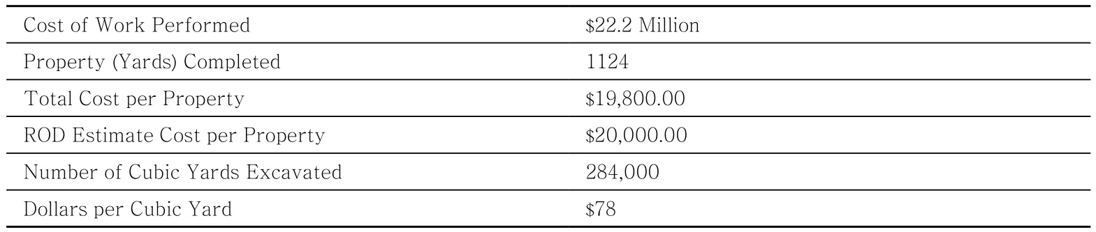
20年间,为解决该区域最为严重的水质、土壤和空气污染问题已经花费了2 220万美元的资金。目前根据州长的报告,修复工作的预算为4 000万美元,即使修复范围有限,一些人仍愿意为此出资。同时,哈佛大学的研究正在计划将更贴近当地情况的活态湿地生态系统整合到项目中。
尾声
以塔溪矿区修复项目为参考,首先我们发现,将一个污染场地放到更广阔的文化和生态背景中对于某些区域的再利用提供了选择的可能,以此可以指导未来进一步的整治措施。第二,目前社区越来越多地参与到了采矿废弃物和遗留物的处理进程中,作为一种改造土地和跨越历史的方式,将整治工程视为一个透明且条理清晰的任务,社区的所有成员均能够参与其中。最后,从长远的角度来看,自下而上的工作方式对于项目的实施起到了至关重要的作用。成功与否应该由项目小规模实施取得的成就来判定,而不是依据常规的再利用评价标准去评判。
通过对自然世界和人工世界的敏锐观察,我们可以在两者之间寻找交汇点。这说明在面对当代“超基金”场地中复杂的有机和人工系统结合的条件下,我们应该以一种具有挑战性的新模式开展相关的修复活动。不过,适应性管理方法应用于经历过极端退化的环境仅仅处于起步阶段。要想挑战现在州和联邦政府大规模使用的传统常规方法,我们需要像塔溪矿区项目中的丽贝卡 吉姆这样有能力的人慢慢而持续地重塑当地社区环境,随着时间的推移,这些方法将在不同的社区、场地、州、超基金土地之间被互相借鉴,广泛传播。
注(Note):
版权:尼尔 柯克伍德,2017年Copyright: Niall G. Kirkwood, 2017
注释(Notes):
①图1、3~ 5、7、8由Niall G. Kirkwood拍摄;图2由Nancy Goldenberg拍摄;图6由Rebecca Jim拍摄。Figure1, 3 ~ 5, 7, 8 : Photograph by Niall G. Kirkwood;Figure2: Photograph courtesy of Nancy Goldenberg;Figure6: Photograph courtesy of Rebecca Jim.
②表1、表2数据来源:美国国家环保局。Source of Table 1 and Table 2: USEPA.
[1]Berger, John and Jean Mohr. A Fortunate Man, London:Writers and Readers Publishing Cooperative, 1981.
[2]Berry, Wendell. Preface, Waste Land, Meditations on a Ravaged Landscape, (ed) David T. Hanson. New York:Aperture, 1997.
[3]Information from USEPA Report, EPA Region 6,Congressional District 02, Tar Creek (Ottawa County).Publication Date, October 4, 2005.
[4]Overheard by the author at a Conference in Miami High on the Tar Creek Superfund, 2002.
[5]Manufactured Sites: An International Landscape Conference and Exhibition on Site Technologies for Contemporary Practice organized by Professor Niall Kirkwood was held at the Harvard Design School,Cambridge, MA in April 1998. Two days of papers and panel discussions were held with international engineers,scientists, designers and EPA regulators on the issues,opportunities and constraints of post-industrial landscapes.
[6]Executive Summary, Final Report of Governor Frank Keating’s Tar Creek Superfund Task Force, 1 October, 2000.
Introduction
Tar Creek in Ottawa County, Oklahoma,a former lead mining area and part of the Tri-State Mining Area of Oklahoma, Kansas and Missouri, represents the failure at multiple levels of administration and overview to address decades of environmental degradation, toxic land conditions and environmental injustice. Communities and environmental of fi cers, in collaboration with local agencies and academic research groups, have started to address the long-term remediation, planning and regeneration of vast mining soil heaps, polluted waterways and rivers, and land subsidence and mineshaft sinkholes that characterize the Superfund site’s landscape and surrounding waste territories(Figure 1).
The story of the long-term reclamation of the forty square mile Tar Creek Superfund Site is presented here as a case study of future landscape planning and design strategies that utilize the resources of local residents, stakeholders, and environmental organizations with the assistance of academic research institutions. I will argue that local-based transformations of the site, as opposed to ‘top-down’ actions, have the potential to act as a framework to unite community desires, address environmental cleanup, and regenerate sequentially over time the entire landscape of a polluted area.
This essay also argues for a holistic way of viewing mining sites that acknowledges and then acts on the need for an incremental approach to land reuse and change within existing local social,cultural and ecological environments. It challenges the strategies that are currently brought to bear on these sites through the existing laws and focuses on the complexity of these landscapes as places with attendant histories, ecologies, communities, and potential futures. It describes the nature, built fabric and materiality of these places and the normative and often simplistic means that have been used to alleviate their current conditions of degradation and contamination. In the end, it is to the people,and the physical landscapes that they shape, restore,or reclaim for their daily uses and future utility, who are the inhabitants of sites such as Tar Creek, and that we turn to for guidance.
As cultural critic John Berger has written[1]and as could be applied to many of the mining sites in our contemporary environment:
Landscapes can be deceptive —
Sometimes a landscape seems to be less a
setting for the life of its inhabitants than
a curtain behind which their struggles,
achievements and accidents take place.
As outsiders, we have to be careful when thinking about a landscape, whether polluted or not, that we know a place and its people. This is especially true for those who have the responsibility to address the serious environmental concerns at mining sites on behalf of Federal, State and Local Agencies or other interested municipal institutions.The focus of this work is broadly concerned with the reclamation of derelict mine land, where the cleaning of land, water and soils becomes a sustainable infrastructural investment for the communities and stakeholders rather than just a selected environmental technique to be applied to a polluted site. The former mining works at the Tar Creek site in North East Oklahoma – a Superfund Site that although it has been under scrutiny since the early 1980’s is still in its very early days of recovery and planning – serves as a useful model for this approach.
Two Sets of Photographs
Nancy Goldenberg grew up and went to grade school within the Tar Creek Superfund Site in Ottawa County, Oklahoma. She has continuously returned from Chicago where she now works as a professional photographer to document the landscapes of Tar Creek, her home landscape.From the vantage point of a light aircraft rented by the hour, she has photographed the local communities, businesses, roadways, homes and her former grade school within an expansive landscape of mining waste (or chat), threaded by orange-red contaminated creeks, rivers and ponds, and littered with collapsed sinkholes as shown in Figure 2.
Interspersed among these formations are the communities of five former mining towns, their streets, homes, schools, stores and people.
Nancy has also driven along the outlying roads, stood beside tree-lined stream beds, walked up the shifting mounds of chat, looked into the modest yards littered with children’s swings and sandboxes, and focused her camera on the playgrounds, ball- fi elds, parking lots and streets of the five former mining towns of Picher, Cardin,Quapaw, Commerce and North Miami as shown in Figure 3.
These are two differing sets of views of the Tar Creek site. One presents a broad and expansive lens (so to speak) toward the mining lands shaped by large tracts of post-industrial waste sites,understood through USGS maps, satellite images,GPS coordinates, production statistics, and historic maps, overlain throughout with small clusters of dwellings, roads and named communities, and more recently described through medical data of children and teenagers, exposure levels and remediation reporting.
The other sees, at a detailed scale, the speci fi cs of the daily life of communities – as shown in Figure 4 – school, work, vegetable gardens, tribal meetings, recreation, church socials, health centers,and baseball leagues, all set within the ravaged environment of Tar Creek. Attempting to describe the magnitude of the environmental problems in this part of the Tri-state Mining Area is dif fi cult.
They include the acidic water in the Tar Creek and the piles of mining waste, the caveins, sinkholes, and fl ooded shafts where men were lowered into the ground to retrieve ore. Yet as Wendell Berry has stated about images such as these, “anybody who troubles to identify in the pictures the things that are readily identifiable,whether roads or buildings, will see nothing in them that is abstract. The power of these places is in their terrifying particularity (as shown in Figure 5). They are the ways, the products and results of human work.[2]” The evolution and reclamation of these places will also be the product of local human work redirected to revitalizing land and restoring the community. The subject of reclaiming and recycling contaminated land has grown in importance to exert a fascination today that is not fully explained by the influence it has had on the planning and rebuilding of regions, communities, infrastructure and open space. Revitalizing land and restoring communities requires multiple views and ways of addressing the issues of remediation, reclamation and recovery– from the broad perspective of planning to the detailed issues of local community development and site design. Mining sites such as Tar Creek offer three possible models for looking at the landscape and understanding these vast areas of modern destruction.
Three Models for Planning
The fi rst model is simply descriptive and sees a site as only defined and created by the residue of its previous industrial activities – these include elements such as the waste piles and abandoned mine shafts that are found at Tar Creek.
The second identifies a combination of engineering and design practices in the “technological circumstances of sites,” where the actual degraded physical conditions are literally “constructed” or“reconstructed.” Here, soil, water-bodies, and landforms are remade and formed through the integration of applied science, engineering and construction. This is one of the normative ways in which the reclamation of sites such as Tar Creek are conceived and actions are organized and carried out.
The third model, most significantly for planners and designers as well as local community and environmental groups, challenges the traditional models of site planning and design, where‘greenfield’ or non-polluted sites are understood through consideration of their inherent natural properties, including information regarding geology,soils, vegetation, microclimate and wildlife. These models are of little use within the contemporary polluted site, particularly in places such as Tar Creek that have been altered far beyond their initial state. The third model offers a new approach for contaminated sites, where the actual physical conditions, whether disturbed or contaminated, are identified and addressed as central to the genesis and understanding of the place.
Over the next several decades, federal, state,and local governments will continue to commit resources annually to clean up lands such as Tar Creek that are contaminated with hazardous waste and toxic materials. A number of questions arise from these actions:
• How will large-scale sites shape the national landscape and our future communities, towns and regions, both within the Superfund sites and outside?
• How do these sites structure the changing needs of scientific, cultural and aesthetic knowledge?
• How does the adaptation of such elements of the landscape as abandoned mining areas,derelict chat fi elds, and toxic river corridors affect how the public will perceive and interact with the natural and manmade world during the rest of the 21st century?
This essay explores proposals for the longterm reclamation of the forty square mile Tar Creek Superfund Site through sustainable planning and design activities and strategies generated at the community level. It addresses the ecologies of the area and why they may be considered “resilient”.It suggests that while the vastness of the land area of Tar Creek under discussion (four miles by ten miles) calls for a broad regional approach to future planning and reclamation efforts, the area’s ecologies have to date represented a failure of the many agencies involved to address decades of environmental degradation, toxic land conditions and environmental justice issues. I do not suggest that these efforts are in themselves wrong or represent an inappropriate application of agency resources or managerial direction and oversight.Rather, I propose that other models exist for addressing these classes of sites that engage in a more holistic way the true conditions of the landscape in its polluted form with the aspirations and strengths of the local environment and communities.
Local communities and environmental officers in collaboration with research groups have begun to address the long-term remediation,planning and regeneration of vast mining soil heaps, polluted waterways and rivers and land subsidence and mineshaft sinkholes. For example,with funding secured by Senator James Inhofe(OK), the U.S. Army Corps of Engineers is closing dangerous open mineshafts, mitigating hazards to local residents with land remediation projects, and leading a multi-agency team of experts to assess the potential for subsidence in higher population areas and along major traffic corridors. The partnership includes the U.S.Army Corps of Engineers, US Environmental Protection Agency, U.S. Department of Interior,the State of Oklahoma, and tribal governments,all of whom were encouraged by Senator Inhofe to sign a Memorandum of Understanding in May 2003 to develop solutions to the human health and environmental threats posed by the Tar Creek site.This led to the Tar Creek and Lower Spring River Watershed Management Plan, a guide for a multidisciplinary solution for all agencies working to solve the complex environmental problems at Tar Creek.
I will argue, however, that while approaches such as the Tar Creek and Lower Spring River Watershed Management Plan act to initiate transformations of the site, other long-term frameworks and approaches are required to unite community desires, environmental cleanup, and landscape regeneration. This need for a locally based long-range framework indicates not just a change to the physical appearance of land or a simple return to productive use of exhausted and currently undervalued vast areas of ground – a tidying up of the past industrial environment – it signals a profound shift in the way communities must lay claim to this, their own, but very polluted land.
First, however, some basic facts are in order about Tar Creek, the conditions that now exist, and how they came to be.
Context of the Tar Creek Superfund Site
The Tar Creek Site is a part of the former Tri-State Mining Area that extended over 700 square miles and included northeastern Oklahoma,southeastern Kansas and reached all the way into the counties of Jasper, Newton and McDonald in southwestern Missouri. The Tar Creek study area of 25,400 acres over 40 square miles is located above 300 miles of abandoned mining tunnels in Ottawa County in the Northeast corner of Oklahoma known as the Old Picher Field lead and zinc mining area. This four by ten square mile area encompasses fi ve towns including Picher and Cardin, as well as the site of over 200 former lead mining operations and milling factories.
At one time, the mountains of milkywhite mine waste as shown in Figure 6 proudly proclaimed Picher as the lead mining capital of the United States. After the war, metals demand declined, and by the 1960s mining operations slowed and fi nally ceased in the early 1970’s when companies left the area and the pumps finally ceased to operate in the mines.
After mining operations stopped, the pumps were turned off and the mines slowly filled with water. Iron pyrite left in waste piles in the mines as well as on the chamber walls and ceilings reacted chemically with the rising water to produce a more potent cistern of acidic water and eventually a 10-billion-gallon vat of subterranean poison, that found its way to the surface as the now familiar acid mine drainage colored a vivid red-orange. In 1978, the U.S. Geological Survey reported that the mines contained 100,000 acre-feet of water.Of that total, the Geological Survey said, 33,000 acre-feet was acidic, which totaled 10,753,097,000 gallons of acid mine drainage water that would eventually discharge into Tar Creek. From there,the acid water spilled into the Neosho River.
The Environmental Protection Agency(EPA) added Tar Creek to the National Priority List in 1981 and has spent more than $40 Million dollars to address some of the most disturbing and confounding water, soil, and airborne contamination problems in the country. It now believes the entire cleanup will cost $500 million dollars, a sum few people are prepared to spend on this site. The silt–sized mining tailings or chat as they are known locally, contain heavy metals,particularly lead and cadmium, and pose serious health risks to children 6 years old and younger.Exposure to lead and zinc found in the chat can cause nervous system and kidney damage,learning disabilities, attention de fi cit disorder, and lower intelligence. A health study in 1999 by the Oklahoma State Department of Health revealed that 38.3% of the children tested in Picher and 62.5 %of the children tested in Cardin had elevated blood lead levels over 10 ug/dL, compared with less than 2.4% for the rest of the state. The expected value for the United States at-large is 4.4%. Although 70% of the study area is tribal land, and 42.5% of the population is Native American, the percentage of children considered at risk is not associated with ethnicity.
The fear of contamination has given way to a calm acceptance of the site by the inhabitants.Toxic waste has set the parameters for future action. Here, it is not a matter of demanding a return to pristine nature on the site. Nor is the central issue the use of reclamation as a point of departure for criticism of the site’s current state.The fundamental ecological base of the landscape and communities has to be restored.
Large political and social forces threaten some parts of the Tar Creek area, while others seem to have been bypassed by contemporary concerns entirely. Many aspects of the site’s past activities remain remarkably intact. All deserve our care and attention, since they, together with thousands of sites large and small, hold the key to the future diversity of human space and what are allowable forms of community and natural life. The surviving towns and communities are devastated by ill-health (particularly in infants and children),lack of employment, and the widespread nature of contamination in their local landscape. Yet through all of this, they retain a pattern of strong cultural and regional identity and a spiritual connection to the land and its inhabitants, creatures and plants expressed through festivals, art and writing.
In the following section, an aspect of the Federal Response concerning the soils surrounding residential yards and community facilities is discussed.
EPA Response—Soil Removal
In 1979, the EPA and the State of Oklahoma became concerned about the acid water and contamination of soils as well as surface and groundwater. The Oklahoma Governor established the Tar Creek Task Force in 1980 to investigate the acid mine drainage. The site was proposed to the National Priorities List (NPL) in 1981 and added in 1983. By June 1984, evaluations had established such a potentially serious risk to human health that a Record of Decision was signed under the Superfund Law. Fourteen years later, in 1998,an EPA Region 6 Emergency Response Team launched a residential soil-sampling program. Soil test results showed that 65% of the homes had yard concentrations greater than 500 ppm. The figures below from EPA documents illustrate property categories within the five towns in the Tar Creek Superfund Study Site – Picher, Cardin,Quapaw, Miami and Commerce – at the beginning of 2000 (Table 1).
Residential remediation activities have been underway since 1996, targeting first those homes with young children and soil lead concentrations above 1,500 ppm (Table 2). Soil is removed in 6 inch layers as shown in Figure 7 until 18 inch depths are reached or the concentrations of lead are below 500ppm. Clean soil is replaced along with shrubs originally removed at the beginning of the excavation, and new grass as shown in Figure 8.
The benefits of federal agency actions as reported in April 2005 are as follows:
“The cleanup of lead-contaminated soils from 2,071 residential yards and high access public areas located within the five-city mining area has significantly reduced the exposure of the population, especially young children. Recent independent studies comparing blood level lead data collected in 1997 to data from 2000 show an approximately 50% decrease in the number of children living in Picher and Cardin between the ages of one and five years old with blood lead levels to or greater than the 10 μg/dL standards set by the CDC. A report in 2004 by the Agency for Toxic Substances and Disease Registry (ATSDR)shows that children living at the Tar Creek site who had blood lead levels in excess of the 10 μg/dL level decreased from 31.2% in 1996 To 2.8%in 2003. This reduction in the number of children with elevated blood levels is attributed to the residential yard cleanups and extensive educational efforts by federal, state, county and tribal entities.Abandoned well plugging has also reduced the potential for contaminants in the shallow Boone Aquifer to migrate to the Roubideax drinking water aquifer[3]”.
As Earl Hatley, former environmental director for the Quapaw Tribe of the Tar Creek region notes, the winds will continue to blow across the chat piles, and two years after remediation the yards will be re-contaminated to the same levels or higher. No further testing has been carried out to confirm or disprove his theory. However,it is likely that the windborne chat will continue to be distributed from the piles across the Tar Creek study site in a microscopic granular layer.In addition, in some cases, “clean soil” has meant water-impermeable clay. The remedial work that removed contamination left the new yards full of clay, homes are retaining moisture from rains, and mold has developed at an alarming rate. This is particularly distressing given the already substantial incidence of asthma in the area.
I want to return to the central argument of this paper regarding the contrast between the conventional approaches (Models 1 and 2) used by the State and Federal agencies to address polluted sites such as Tar Creek and the local knowledge and understanding of the actual physical conditions,whether disturbed or contaminated that can lead to an alternative (Model 3). This model is more sustainable for the long-term approach to cleaning up and regenerating large and complex land areas over time and including the close involvement of all stakeholders including community partners and participants. The difference between the two sets of approaches is striking. On the one hand the normative methods (Models 1 and 2) used under the current modes of engineering analysis,evaluation and response focus on a narrow way of looking at contamination insitu. In short the site is in an arrested state of succession or development where the levels of contamination can be measured, evaluated and removed within a single time frame. The site is then returned to a clean state, a tabla rasa that is devoid of any pollutants, a natural benign landscape where the land, dwellings and people are in harmony. On the other hand,the solution appears to have solved the most pressing need- that of immediately addressing the health problems of lead poisoning to the town’sresidential communities particularly the young and the elderly. By removing the immediate source of lead in the top eighteen inches of residential yard soil and replacing it with clean soil an immediate result is gained. It can be quantified, measured and mapped and to date has resulted in the most serious efforts in economic and engineering terms to remediate the Tar Creek area. While this approach looks to a short-term response to ‘solve’the problem of contamination it avoids what turns out to be the ‘real problems’ associated with sites such as Tar Creek- simply that they are the product of a relentless industrial process (mining)that occurred over a long period of time. In doing so the mining activities and its residues and wastes acted gradually on the environment to alter ecosystems, adjusting the nature of hydrologic systems and the structure of soils and sediments.In doing so vegetation, wildlife and aquatic life were also severely altered. Finally the interaction of these patterns of contamination and alterations to the soils and water on the human population has occurred and will continue to occur over signi fi cant period of times even though the soil removal exercise from residential yards has taken place. It is not possible to undo over a hundred years of mineral extraction and its large-scale effect on the land in an instant, nor is it possible to continue to view the process of cleaning as a simplistic linear activity. Rather it requires an adaptive model that accepts the changing circumstances of pollution and remediation techniques over time in concert with a profound shift towards communities and local stakeholders being involved as active participants rather than passive onlookers.

Tab.1 Property categories by town, Feb. 2000.
Tab.2 Yard remedial action status, March 2000.
This speaks to the inability of Models 1 and 2 to answer the deeper and more significant problems associated with the Tar Creek site. The environmental disturbance is vast and widespread and it will require long-term remediation efforts to address the chat piles, the condition of the water bodies, the subsidence of the ground and the airborne contamination. It also speaks of the need to move towards a different way of addressing the planning of the reclamation of the Tar Creek site area, one that is more receptive to the actual conditions of the site, both physical and cultural as well as to involve all stakeholders and communities in the process. Large-scale long-term remediation requires local knowledge and a large-scale design vision to be attained in small stages over signi fi cant periods of time. Some of the challenges posed by these large-scale remediation efforts are immense,concerned with incremental changes over time to the very nature of the landscape, continuous monitoring of both the original conditions and the remediation in progress, and adequate mapping of the cultural as well as environmental fabric that is to be identi fi ed and addressed as central to the genesis and understanding of the place.
In direct contrast to the EPA’s selected remedy(Alternative 2 in the March 1997 Proposed Plan),one part of the study project carried out by the Harvard Team that follows tests a hypothesis that addresses the key points expressed by Earl Hatley on the long-term nature and extent of contamination and to show that community-based planning models can more effectively curtail high soil lead concentrations in targeted study areas within the Superfund Site. Efforts are underway through this proposal to integrate a locally-based site strategy with a long-term land renewal effort.
The Harvard Community-Based Prevention and Intervention Research Project
The Tar Creek research project currently underway combines the efforts of faculty and researchers across three graduate schools at Harvard University – the Medical School, School of Public Health and Graduate School of Design.Founded through contacts that arose out of various subcommittees it involves Dr. Howard Hu of the Harvard Medical School, Dr. Lucia Lovinger of the Harvard Science Center, Professor Jack Spengler of the Harvard School of Public Health,Dr Robert Wright of Brigham and Women’s Hospital in Boston, and the author representing the Graduate School of Design, as well as Rebecca Jim of L.E.A.D, the local community group on site in Oklahoma.
The Harvard Community-Based Prevention and Intervention Research Project has three main components. First, the project includes a community based study of lead exposure biomarkers focusing on children in the study area. Second, there is a study of lead-exposure pathways tracking the movement of lead from mine spoil to various populations that includes studies on cultivated and foraged foods consumed by residents and wildlife. Third, in the future the project will examine remediation design tools and approaches to reduce lead at the larger site scale through innovative remediation and design techniques. It proposes to develop a model that will join other efforts at environmental remediation of contaminated areas such as a pilot passive wetland treatment system and a wetlands and wildlife refuge while addressing land subsidence, flooding, mine drainage discharges and chat pile distribution. For example in its most vivid approach to communitybased remediation, it will attempt to join efforts at environmental remediation of contaminated sites using living planted systems, an emerging technology called phytoremediation with long-term environmental restoration and reclamation of the broader land and water bodies. Thus, it promises to integrate a locally-based site strategy with a longterm land renewal effort and supports the necessity of moving to an adaptive management approach(Model 3) to address the long-term future of Tar Creek in the fi rst half of the Twenty First century.
Innovative Community-based Remediation
One important aspect of the Harvard Collaborative approach is the use of a localized remediation strategy- phytoremediation, to engage at the same time, the local community in planting,monitoring and harvesting as necessary that works the land in a respectful way that is closer to agricultural practices rather than engineering remediation. The continuation of the community and local stakeholders investment in this activity carries over time as the long-term evolution of the phytoremediation system works over the years to both clean up pollutants as well as establish a new plant ecosystem that will vegetate the chat piles, clean up wetlands, clean residential yards in an organic and holistic way. The long timeline associated with this process is usually seen over thirty years with short term results in one year or three growing seasons.
Drawing on basic research about the natural abilities of plants to accumulate lead from soils and groundwater, phytoremediation (literally meaning plant-cleanup) is viewed as a low-cost alternative natural treatment technology for lead contaminants.It is a low-cost in situ technology that employs the use of plants, including trees, grasses and aquatic vegetation to remove, sequester and uptake hazardous substances from the environment. It offers promise as a versatile strategy suitable for use on contaminated sites with a range of pollutants.
Living plants naturally capable of accumulating large amounts of metals such as lead (hyperaccumulators) were first described in 1948. Early exploratory studies were carried out primarily in Europe mainly related to the reuse of mining spoil and waste sites in the rebuilding efforts following World War II. Research however, did not start in earnest until the middle 1980’s in the United States,when the original mechanisms of phytoremediation were described in laboratory experiments. These can be grouped into three broad categories,based on the fate of the contaminant in question:accumulation, degredation and hydraulic control.Optimizing the effects of phytoremediation,the plants are generally densely planted in either rows perpendicular to the flow of a subsurface groundwater plume or in clumps or patches known as hotspots where the contamination occurs in concentrated soil areas. These have the ability to be applied in areas of high lead within communities including playing fields, river walkways and parks. The question posed by such a technology concerns the increased net environmental benefit of integrating a community-based model phytoremediation plan to reduce lead levels with other community concerns, and carrying out such efforts over the long-term.
A Single Bracelet does not Jingle
Rebecca Jim has often stated in presentations an old proverb that says “a single bracelet does not jingle”[4]. Phytoremediation research projects by their very nature foster collaboration between different fields of science and between different professions and communities. The potential also exists to integrate phytoremediation with other forms of environmental planning and design enterprises; for example, pump and treatment wetland systems, greenways, and solar technologies.The cleanup of lead by phytoremediation has been shown at a number of full-scale demonstration projects as an alternative to more established treatment methods used at hazardous waste sites,such as soil removal and replacement as has been carried out to date at Tar Creek. Limitations to its application at more conventional sites include the extended time-scale of phytoremediation activities in comparison to competing remedial technologies,and the inherent limitations of biological systems.Its low cost (approximately 70-100 times cheaper than conventional remediation techniques) makes it appropriate for sites such as Tar Creek, where a longer time-scale is necessary and the site holds the potential to integrate this approach with other community-based land redevelopment projects.
Initial testing of a phytoremediation approach using vegetation in the field was carried out over the summer of 1999 by graduate student Markley Bavinger. Through all phases of the research,adults and college and high school students living in the community were involved in the survey of opportunistic and/or native vegetation and their patterns of growth in targeted site areas.Design projects will later address specific test areas where phytoremediation installations will be integrated with community proposals for the river corridor, the containment of the mining waste sites, and residential areas and school yards.Phytoremediation is effective only in certain conditions. A phytoremediation scheme will make sense only if there are appropriate growing conditions, contaminant densities, soil aeration conditions, and time constraints on remediation.Planners, scientists and communities can play a role in the prevention of polluted landscapes by designing site and land-use codes that anticipate the presence of toxins and mitigate that presence with hyperaccumulators. During the “Manufactured Sites” Conference at Harvard Design School in 1998[5], one participant explained, “On some sites it is possible to place planting in such a way as to allow partial reuse of the site for public access or ongoing development while the cleanup is in process. Here, phyto-remediation and creative site design are united by the use of planted systems that both remediate and at the same time establish spatial and functional patterns of use.”
Some of the preliminary efforts to address these issues within the Harvard Collaborative study have resulted in an examination with the local environmental groups of how the labor intensive remediation planning and installation process could be integrated into the land ethic projected by the various local community organizations.This involves educational and Native American initiatives to foster various groups in the area to become engaged in the monitoring of ecosystems as well as review agricultural practices in the area,particularly where food production is coupled with remediation practices. The issues of overall coordination and management of Model 3, the Adaptive Management Approach are enacted at the local level with various feedback loops to the Federal and State agencies and academic institutions.
Governor Frank Keating’s Tar Creek Superfund Task Force
Parallel to the work by the EPA and the Harvard Collaborative Group, the report on a major initiative on Tar Creek was issued in October 2000. Prepared by the Oklahoma State Of fi ce of the Secretary of Environment, it was commissioned by the Governor to give further impetus to the resolution of problems that remained at the Tar Creek site. The vision for the site was:
“To establish a world-class wetlands area and wildlife refuge within the boundaries of the Tar Creek Superfund Site that will serve as an ecological solution to the majority of the most pressing health, safety, environmental and aesthetic concerns.[6]”
This study, in addition to the principles underlying the Harvard project, suggests an awakening of interest in using a sustainable longterm approach to the problems of Tar Creek and its communities.
The Interim Measures established by the Final Report included the following, to be carried out as a Superfund Remedial Investigation/Feasability Study (RI/FS):
• Undertake a comprehensive study of minewaste drainage to determine amount and types of treatment wetlands;
• Initiate a pilot wetland treatment system to determine the most effective and feasible systems for the area;
• Develop and test appropriate uses of large volumes of chat to establish markets for its export;
• Identify mine shafts that need plugging and test various closure methods; and
• Investigate the bio-availability of heavy metals resulting from the consumption of wild forage foods.
In addition, the following issues are to be carried out:
• Establish a local industrial authority to develop the necessary infrastructure and appropriate regulatory climate for large-scale aggressive chat marketing and export;
• Assemble a local steering committee to explore options for, and feasibility of, the relocation of the towns of Picher/Cardin;
• Create a Geographic Information System(GIS) ad hoc committee to compile all available data and information on the Superfund area, to allow for better decisions to be made about all aspects of the future remediation effort; and
• Develop a better EPA, DOI, Tribal, and State partnership to hasten cost recovery /NRDA reimbursement.
$22.2 million has been spent over almost 20 years to address some of the most confounding water, soil, and airborne contamination problems in the country. The remediation and recovery as currently defined by the Governor’s Report should cost $40 million dollars, a sum few people are prepared to spend on this site although the scope of remediation is still limited. However, the integration of a larger living ecological systemthe wetland with more locally based initiatives as outlined in the Harvard study suggests.
Endings
How can stakeholders in the Superfund process whether planners, lawyers, designers, or community leaders re-interpret the chronology of a site, be it natural, industrial or cultural in its disposition, in a speci fi c geographic location? And how can reclamation and reuse activities shape a Superfund site into a community environment within the cultural artifice of a post-industrial landscape? The Harvard Collaborative study is focused on carrying out a large-scale plan that accommodates the community in a long-term remediation of the land and waterways while acknowledging the specifics of the ecology and physical nature of the local environment. In it,plants native to the area assist in the absorption of pollutants guided by communities of the site and cultural practices of the place.
First, we have found that with reference to the Tar Creek Project, putting the site within a larger cultural and ecological context has considerable implications for reuse options used in selected parts of the area and how further remediation selection has to proceed in the future. Second, to date, the community has engaged incrementally with the residue of mining activities and historic traces as a way of reclaiming their own territory and past, looking at the remediation as a transparent and legible process involving all members of the community. Finally, viewing the site over the longterm as an effort from the bottom-up is essential to successful project implementation. Success should be measured by small-scale achievements instead of normal benchmarks for reuse.
By looking observantly upon the natural world as well as the disposable world, we may build at the great overlap between the two. This suggests a challenging new model for how we ought to work within the contemporary Superfund environment with a new quality of attention to the intricate organic and artificial systems of reality. The application of Adaptive Management methods to landscapes that have undergone drastic environmental degradation is only in its infancy.In being able to overcome the normative methods currently understood by the vast majority of the employed by Federal and State authorities it will require the ability of individuals like Rebecca Jim on Tar Creek to slowly and sustain ably build her community and in time these actions will pass from community to community, site to site, state to state,superfund land to superfund land.
Toxic Kingdom / Tar Creek Futures—The Case of Picher & Cardin Mining Areas, Ottawa County, Oklahoma, USA
Author: (USA) Niall G. Kirkwood Translator: LI Jia-yi Proofreader: WANG Xi-yue
A case study of long-term planning and reclamation of the forty square mile Tar Creek Superfund Site is presented through sustainable planning and design activities and strategies at the community level. Tar Creek in Ottawa County, Oklahoma, a former lead mining area and part of the Tri-State Mining Area represents the failure of federal and state agencies to address decades of environmental degradation, toxic land conditions and environmental justice issues. Local communities and neighborhoods and environmental officers in collaboration with academic research groups have addressed the long-term remediation, planning and regeneration of vast mining soil heaps, polluted waterways and rivers and land subsidence and mineshaft sinkholes. The case study will argue that the localbased transformations of the site act as a framework to unite community desires, environmental cleanup, and landscape regeneration.
mining sites; post-industrial landscape; superfund; landscape reclamation; waste land
进程中的利益相关者,无论是规划师、律师、设计师或社区领导,应该如何重新诠释场地的发展历程,是采取自然的、工业的或文化的处理策略,或是依托于特定的地理环境?整治修复和再利用工程应如何在“超基金”场地中塑造后工业文化景观背景下适宜的社区环境?哈佛大学合作研究重点是开展一项大规模整治计划,使社区在生态和环境上适应土地和河道的长期修复过程。在研究中,可吸收污染物的乡土植物规划是以当地社区和栽培实践技术为指导的。
TU 986
A
1673-1530(2017)08-0014-16
10.14085/j.fjyl.2017.08.0014.16
2017-05-25
修回日期:2017-06-15
(美)尼尔 柯克伍德/ 美国风景园林师协会理事/ 哈佛大学风景园林与技术教授,风景园林系前主任/技术与环境中心创始人与主任
(USA) Niall G. Kirkwood, Doctor of Science, FASLA, is a professor of Landscape Architecture and Technology,Department of Landscape Architecture and founder and current director of Center for Technology and Environment at the Harvard University Graduate School of Design in Cambridge, Massachusetts.
译者简介:李佳怿/1993年生/女/吉林人/北京林业大学园林学院在读硕士研究生/研究方向为风景园林规划设计与理论(北京100083)
LI Jia-yi, who was born in 1993 in Jilin, is a master student in the School of Landscape Architecture, Beijing Forestry University. Her research focuses on landscape planning and design (Beijing 100083) .
校者简介:王晞月/1992年生/女/北京人/北京林业大学园林学院在读博士研究生/研究方向为风景园林规划与设计(北京100083)
WANG Xi-yue, who was born in 1992 in Beijing, is a Ph.D.student in the School of Landscape Architecture, Beijing Forestry University. Her research focuses on landscape planning and design (Beijing 100083).
(编辑 / 任京燕)