不同农业耕作措施下坡耕地填洼量特征与变化
2017-10-14赵龙山吴发启戴全厚
赵龙山,侯 瑞,吴发启,戴全厚
不同农业耕作措施下坡耕地填洼量特征与变化
赵龙山1,2,侯 瑞1,吴发启2,戴全厚1
(1. 贵州大学林学院,贵阳 550025;2. 西北农林科技大学资源环境学院,杨凌 712100)
洼地蓄水是坡耕地重要的水文要素,由于它与坡耕地产流、土壤入渗能力有关,故也是坡面水土流失研究的重要对象之一。为了进一步认识坡耕地洼地蓄水作用,该研究通过人工模拟降雨试验方法,对3种常用农业耕作措施(人工锄耕、人工掏挖、等高耕作)条件下地表填洼量特征与变化进行了深入研究,以平整坡面为对照措施。研究结果表明,实施农业耕作措施的粗糙坡面平均填洼量较平整坡面提高4~13倍,洼地蓄水量依次为等高耕作>人工掏挖>人工锄耕>平整坡面;坡度对填洼量具有重要影响,洼地蓄水量随着坡度的变化可以用幂函数关系表达(2>0.70)。对于粗糙坡面,当坡度从15°增大到25°过程中,洼地蓄水量逐渐趋于稳定,受坡度的影响变小;在耕作坡面上,由于降雨侵蚀造成地表微地形变化,地表糙度减小,洼地蓄水量减小,地表填洼量变化可以通过地表糙度变化进行计算。
土壤水分;侵蚀;降水;地表糙度;模拟降雨
0 引 言
地表填洼量是指地表相对低洼处蓄存的水量,用地表洼地蓄水量表示(surface depression storage, SDS),由于它与坡耕地产流产沙、土壤入渗能力有关,故也是坡面水土流失研究的重要对象[1]。在水文学中,地表填洼量还是模拟坡面产流与退水过程的一个重要因子[2-3]。近年来,随着三维激光扫描技术在土壤侵蚀研究领域的广泛应用,针对填洼量及其相关内容的研究逐渐增多[4-5],为坡面土壤侵蚀与产汇流理论的发展奠定了科学依据。
在坡耕地上,由于耕作活动的影响,地表土壤呈现一定的高低起伏,使地表形成许多大小不同的洼地。对于不同的农业耕作措施,洼地的大小与空间分布特征具有一定差异[6]。在降雨产流过程中,洼地具有滞蓄径流和沉积泥沙的作用,从而降低水土流失的发生[7-8]。大量的研究表明[9-11],在不同的产流阶段,洼地作用不同,在降雨产流初期,洼地以蓄水作用为主,导致坡面产流延缓,增加降雨入渗的时间和潜在入渗量。Guzha[12]研究表明,在有洼地的坡面,土壤入渗率显著高于平整坡面,且地表填洼量越大时,对应土壤的含水量也越大;在坡面产流后,径流搬运的部分泥沙在洼地沉积,洼地起到拦截泥沙的作用,进而减小土壤流失量。同时,在坡面产流过程中,对不同坡位上或不同大小的洼地,蓄水时间长短不同,导致产流曲线呈现阶梯式上升特征,因此洼地对产流量的影响还与洼地空间特征有关[13]。当坡面产流达到稳定后,地表填洼量对径流特征的影响不明显[14]。Darboux等[15-16]研究表明,地表填洼量是逐渐蓄满的过程,它可以改变径流方向,是一个重要的径流模拟特征参数。
以上分析表明,地表填洼量是研究地表产流与汇流过程的重要特征量。但是,在降雨侵蚀作用下,地表填洼量并不是固定不变,而是随着地表微地形的变化而变化,而这种变化目前还不清楚。鉴于此,本研究以坡耕地采用的人工锄耕、人工掏挖、等高耕作等土地管理措施为研究对象,通过人工模拟降雨试验的方法,对坡度、降雨侵蚀作用下地表填洼量特征进行定量研究,以期为坡耕地水土流失过程与机理奠定科学基础。
1 材料与方法
1.1 研究方法
本研究采用室内人工模拟降雨的试验方法。降雨设备用中国科学院水土保持研究所黄土高原土壤侵蚀与旱地农业国家重点实验室研制的侧喷式模拟降雨系统,降雨高度15 m,降雨均匀度大于80%,单个试验区有效降雨面积约36 m2。侵蚀槽规格2.0 m´1.0 m´0.5 m(长´宽´深),侵蚀槽坡度可在0~40°范围内任意调节。
试验土壤取自坡耕地表层土(0~20 cm),经测定,土壤颗粒粒径>0.05 mm占比2.82%,粒径在0.01~0.05mm占比41.13%,粒径<0.01 mm占比56.05%。
土壤自然风干后(土壤含水率控制在10%左右),先过10 mm筛,然后将土壤分层装入侵蚀槽,槽内土壤深度为0.4 m。在填装土壤过程中,采用体积质量随机实测法,将侵蚀槽内土壤容重控制在1.3 g/cm3左右,以使土层均匀且体积质量接近土壤自然剖面。侵蚀槽装土完成后,先利用木块将表土整平,并将侵蚀槽坡度调至试验坡度,然后按传统的耕作措施在坡面上进行耕作,以模拟不同地表条件或地表糙度[17]。耕作措施包括人工锄耕、人工掏挖和等高耕作,其中:1)人工锄耕:沿地表以传统方式锄耕,深度4~5 cm;2)人工掏挖:采用镢头掏挖地表,深度5~8 cm,间距20~25 cm;3)等高耕作:在坡面上垂直于坡面方向进行横向犁耕,形成沟和垄,垄高7~10 cm,垄距为30 cm。另外,本研究用未实施耕作,土壤表面呈平整状态的坡面作为对照措施(平整坡面)。以上措施耕作模拟聘请长期从事相同耕作与农业生产的农民进行操作,以保证模拟耕作更接近实际生产。
耕作措施模拟完成后,立刻用10 mm/h降雨强度对侵蚀槽内土壤进行30 min预降雨,降雨后将侵蚀槽静置24 h再开始正式降雨试验,以恢复地表土壤粘结力,降低人为干扰。对每个侵蚀槽,在降雨试验开始前和降雨后,都需测量地表填洼量。
试验设计5个试验坡度:5°,10°,15°,20°和25°。试验降雨强度90 mm/h,降雨历时60 min。试验共使用4个侵蚀槽,分别标记为C1,C2,C3和C4,其中C1,C2和C3用来模拟人工锄耕、人工掏挖和等高耕作,C4为平整坡面。对每一个措施,均从最小坡度5°开始依次完成5个坡度的试验。每个坡度试验完成后,侵蚀槽内土壤全部更换新土,准备下一次试验。每个坡度重复3次,重复试验程序同上。
运用链条法测量不同耕作措施坡面的地表糙度,计算公式如下[18]:

式中表示地表糙度,%;0和1分别表示链条的实际长度和放置地面后链条的水平长度,m。通过计算初始地表糙度(0)和雨后地表糙度(t)比值来表征降雨侵蚀作用下地表糙度变化。
1.2 地表填洼量测量与分析
本研究中,地表填洼量是指耕作后坡面洼地的最大蓄水量,其值通过在地表覆盖塑料薄膜的方法进行实测。主要是将农用薄膜铺在坡耕地表面以阻止水分入渗,从坡顶向坡面注水直至坡面全部凹陷处蓄满水且从坡底集流口出水为止,记录注水量与出水量,二者作差得最大蓄水量[19]。本研究将5个坡度下地表初始填洼量均值作为衡量耕作措施地表填洼量的数量指标。
地表填洼量变化分析公式如下:

式中表示降雨侵蚀前后地表填洼量变化,%;DS表示雨后地表填洼量,mm;0表示初始地表填洼量,mm。若为正值,表示降雨侵蚀后地表实际填洼量较降雨前初始填洼量增加;反之,则表示减小。
运用最小二乘法原理对地表填洼量与地表糙度之间的关系进行回归分析,建立地表糙度与地表填洼量之间的函数关系。
2 结果与分析
2.1 不同耕作措施坡面地表填洼量特征
不同耕作措施坡面地表填洼量特征结果见图1。可以看出,与平整坡面相比,耕作措施显著提高坡面地表填洼量。对不同耕作措施坡面,初始地表填洼量具有一定区别,但是,除在坡度为10°、15°和20°时,等高耕作与人工锄耕、人工掏挖之间有显著差异外,其余坡度下差异不显著。总体上,在不考虑坡度影响下,等高耕作、人工掏挖和人工锄耕坡面的平均填洼量分别为6.96、3.52和2.48 mm,是平整坡面填洼量的4~13倍。与平整坡面相比,耕作措施具有增加地表糙度的作用。郑子成等[20]研究表明,在采取人工掏挖、等高耕作和人工锄耕的坡面上地表糙度的大小与地表填洼量具有相似的趋势,即等高耕作>人工锄耕>人工掏挖>平整坡面。可见,在坡耕地上,耕作措施在增加地表糙度的同时显著提高地表蓄水能力,这一特征为农业耕作措施发挥水土保持作用提供了基本条件。
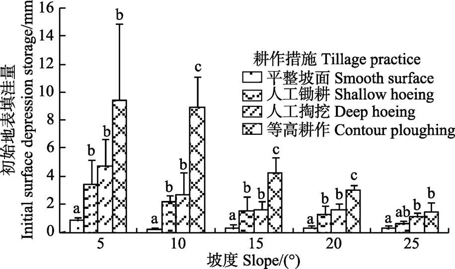
注:不同小写字母表示不同措施间差异显著(P<0.05),相同字母表示差异不著性,下同。
2.2 坡度对初始地表填洼量的影响
对不同耕作措施坡面地表填洼量与坡度关系分析结果见图2。可以看出,坡度对地表填洼量影响较大,即随着坡度增加,地表填洼量明显减小。应用最小二乘法对地表填洼量与坡度关系进行分析发现地表填洼量随坡度的减小特征可用幂函数表达,即:
=ab(2>0.78) (3)
式中表示地表填洼量,mm;表示坡度,(°);和为回归系数。对于不同的耕作措施,回归系数相差较大,而幂指数较为接近,说明坡度对不同耕作措施坡面地表填洼量的影响程度存在差异。初始地表填洼量越大,坡度的影响也越大。同时,地表填洼量与坡度的幂函数关系也说明坡度对地表填洼量的影响存在临界坡度,当坡度大于该临界值后,坡度的影响减小,地表填洼量趋于稳定值。对于平整坡面,当坡度在10°~25°之间时,平均填洼量在0.21~0.29 mm之间变化;对于人工锄耕、人工掏挖和等高耕作等粗糙坡面,当坡度从15°增大到25°过程中,平均填洼量趋于稳定,随坡度的变化减小。
地表糙度是对耕作措施下坡面微地形特征进行量化的指标,已有的研究表明地表糙度的大小与坡面水土流失具有一定关系[21]。在地表糙度与坡面产流产沙研究中,地表填洼量被认为是影响产流产沙的一个重要抑制因子[22-23]。随着地表糙度的增加,地表洼地蓄水能力逐渐增强[12,22],本研究也证实了这一观点。同时,我们也发现地表填洼量不仅与地表糙度有关,还受坡度的影响,但是坡度对地表填洼量有一定的影响。在坡面水文过程模拟研究中,当地面坡度大于一定数值后,坡面蓄水能力不再受坡度影响,可以取定值。

图2 坡度对地表填洼量的影响
2.3 降雨侵蚀对地表填洼量的影响
对不同耕作措施坡面地表填洼量受降雨侵蚀的影响分析结果见图3。可以看出,人工锄耕、人工掏挖和等高耕作等粗糙坡面与平整坡面降雨侵蚀前后地表填洼量变化呈不同的变化特征。对于平整坡面,在连续降雨(降雨量90 mm)侵蚀作用后,5个坡度条件下雨后地表填洼量均较初始地表填洼量增大,增加量在30%以上;相反,对于等高耕作、人工掏挖和人工锄耕坡面,地表填洼量均呈减小特征,最大减小量约60%。另外,对于粗糙坡面,除坡度为25°外,初始地表填洼量越大,相应的地表填洼量减小量也越大。以上结果说明降雨侵蚀作用对地表蓄水能力具有重要影响。
统计分析表明,尽管在个别坡度下,不同耕作措施之间地表填洼量存在显著差异,但是并无明显规律。如,在坡度为5°和10°时,人工掏挖和等高耕作之间并未显著差异,但是在坡度为15°时,又存在显著差异。可见,对不同耕作措施坡面,坡度并未对地表填洼量变化产生显著影响。
对不同耕作措施地表糙度与地表填洼量变化关系进行分析(图4),可以看出,等高耕作、人工掏挖和人工锄耕坡面雨后地表糙度(t)较初始地表糙度(0)减小。但是,在平整坡面上,t却增大。可见,地表填洼量的变化与地表糙度变化具有相似趋势,即对于地表糙度增加的平整坡面,地表填洼量呈增加趋势;相反,对地表糙度减小的粗糙坡面,地表填洼量呈减小的趋势。究其原因,笔者认为这与地表土壤侵蚀过程有关。对于粗糙坡面,受径流和泥沙沉积影响,地表洼地逐渐被上坡来沙填平,同时,侵蚀产流过程中形成的汇流网络将分散的洼地逐渐连通,坡面排水性增强,洼地的蓄水能力降低,导致地表填洼量减小[24-26];相反,对于平整坡面,侵蚀产流过程中坡面形成的鱼鳞坑及汇流网络反而增加了坡面的区域,导致地表填洼量呈增加的趋势[27-28]。
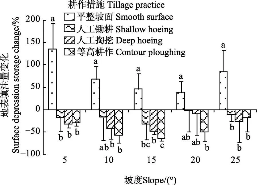
图3 降雨后不同耕作措施坡面地表填洼量变化
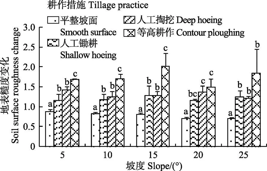
图4 降雨后不同耕作措施坡面地表糙度变化
为了进一步阐明地表填洼量与地表糙度的关系,运用最小二乘法原理对地表糙度变化与地表填洼量之间的关系进行分析,二者存在如下数量关系:

上式表明,降雨前后地表填洼量比值与地表糙度变化之间存在对数函数关系。
根据公式(4),在获得坡面某一时间段内地表糙度变化,即可计算该时段后地表填洼量。为了验证这一关系的准确性,用35组不同耕作措施坡面降雨资料(表1)对地表填洼量进行模拟计算,并绘制地表填洼量预测值与实测值散点图,结果见图5。运用最小二乘法原理回归分析表明地表填洼量实测值与预测值之间存在显著线性关系(<0.05),进一步表明地表填洼量与地表糙度之间的数量关系,即通过降雨前后地表糙度比值可以计算地表填洼量。
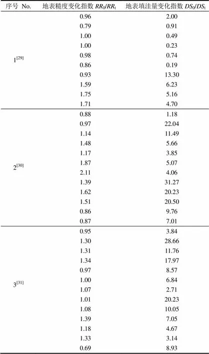
表1 降雨试验资料
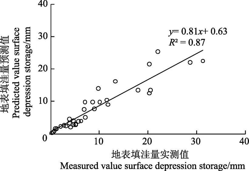
图5 地表填洼量预测值与实测值准确性分析
3 结 论
本研究通过人工模拟的试验方法,对不同耕作措施下坡耕地地表填洼量的特征与变化进行了研究,得出如下结论:
1)与无耕作措施的平整坡面相比,实施农业耕作措施的粗糙坡面平均填洼量提高4~13倍,洼地蓄水量依次为等高耕作>人工掏挖>人工锄耕>平整坡面。
2)坡度对填洼量具有重要影响,随着坡度的增加,洼地蓄水量呈幂函数规律逐渐减小。当坡度大于15°后,粗糙坡面洼地蓄水量逐渐趋于稳定,受坡度的影响变小。
3)对不同耕作措施坡面,初始地表填洼量越大,在降雨侵蚀中地表填洼量变化也越大。但是,坡度对地表填洼量变化并未显著影响。
4)由于降雨侵蚀造成地表微地形变化,地表糙度减小,粗糙坡面洼地蓄水量减小,地表填洼量变化可以通过地表糙度变化进行计算。
[1] Planchon O, Esteves M, Silvera N, et al. Microrelief induced by tillage: Measurement and modelling of surface storage capacity[J]. Catena, 2001, 46(2/3): 141-157.
[2] 芮孝芳. 产汇流理论[M]. 北京:水利电力出版社,1995.
[3] 白清俊,刘亚相. 流域坡面综合产流数学模型的研究[J]. 土壤侵蚀与水土保持学报,1999,5(3):54-58. Bai Qingjun, Liu Yaxiang. Integrated model of runoff generation over valley slope surface[J]. Journal of Soil Erosion and Soil and Water Conservation, 1999, 5(3): 54-58. (in Chinese with English abstract)
[4] Chu Xuefeng, Yang Jun, Chi Yaping. Quantification of soil random roughness and surface depression storage: Methods, Applicability, and Limitations[J]. Transactions of the American Society of Agricultural and Biological Engineers, 2012, 55(5): 1699-1710.
[5] Martin Y, Valeo C, Tait M. Centimetre-scale digital representations of terrain and impacts on depression storage and runoff[J]. Catena, 2008, 75(2): 223-233.
[6] 赵龙山,张青峰,宋向阳,等. 基于微尺度下DEM的黄土坡耕地地表坑洼特征研究[J]. 土壤学报,2012,49(1):179-183. Zhao Longshan, Zhang Qingfeng, Song Xiangyang, et al. Study of characteristics of surface depressions in farmland on loess slope based on micro-DEM[J]. Acta Pedoloca Sinca, 2012, 49(1): 179-183. (in Chinese with English abstract)
[7] Darboux F, Huang C H. Does soil surface roughness increase or decrease water and particle transfers?[J]. Soil Science Society of America Journal, 2005, 69(3): 748-756.
[8] Zhao Longshan, Huang Chihua, Wu Faqi. Effect of microrelief on water erosion and their changes during rainfall[J]. Earth Surface Processes and Landforms, 2016, 41(5): 579-586.
[9] Huang J K, Lee K T. Influences of spatially heterogeneous roughness on flow hydrographs[J]. Advances in Water Resources, 2009, 32(11): 1580-1587.
[10] Antoine M, Chalon C, Darboux F, et al. Estimating changes in effective values of surface detention, depression storage and friction factor at the interrill scale, using a cheap and fast method to mold the soil surface micro-topography[J]. Catena, 2012, 91(12): 10-20.
[11] Zhao Longshan, Wang Linhua, Liang Xinlan, et al. Soil surface roughness effects on infiltration process of a cultivated slopes on the Loess Plateau of China[J]. Water Resources Management, 2013, 27(14): 4759-4771.
[12] Guzha A C. Effects of tillage on soil microrelief, surface depression storage and soil water storage[J]. Soil & Tillage Research, 2004, 76(2): 105-114.
[13] Chu Xuefeng, Yang Jun, Chi Yaping, et al. Dynamic puddle delineation and modeling of puddle-to-puddle filling-spilling-mergingsplitting overland flow processes[J]. Water Resources Research, 2013, 49(6): 3825-3829.
[14] Darboux F, Gascuel-Odoux C, Davy P. Effects of surface water storage by soil roughness on overland-flow generation[J]. Earth Surface Processes and Landforms, 2002, 27(1): 223-233.
[15] Darboux F, Davy P, Gascuel-Odoux C. Evolution of soil surface roughness and flowpath connectivity in overland flow experiments[J]. Catena, 2001, 46(2/3): 125-139.
[16] Gómez J A, Darboux F, Nearing M A. Development and evolution of rill networks under simulated rainfall[J]. Water Resources Research, 2003, 39(6): 1148-1162.
[17] 赵龙山,张青峰,梁心蓝,等. 基于GIS的坡耕地数字高程模型的建立与应用[J]. 农业工程学报,2010,26(11):317-322. Zhao Longshan, Zhang Qingfeng, Liang Xinlan, et al. Establishment and application of DEM for loess slope land based on GIS[J]. Transactions of the Chinese Society of Agricultural Engineering (Transactions of the CSAE), 2010, 26(11): 317-322. (in Chinese with English abstract)
[18] Saleh A. Soil roughness measurement: Chain method[J]. Journal of Soil and Water Conservation, 1993, 48(6): 527-529.
[19] 宋冰,赵龙山. 微地形条件下地表填洼量计算方法研究[J]. 杨凌职业技术学院学报,2011,10(3):5-7. Song Bing, Zhao Longshan. Calculation of surface depression storage under micro-topography condition[J]. Journal of Yangling Vocational & Technical College, 2011, 10(3): 5-7. (in Chinese with English abstract)
[20] 郑子成,何淑勤,吴发启. 降雨条件下耕作方式对地表糙度的溅蚀效应[J]. 农业工程学报,2009,25(11):103-108. Zheng Zicheng, He Shuqin, Wu Faqi. Splash erosion effects of tillage practices on soil surface roughness under different rainfall conditions[J]. Transactions of the Chinese Society of Agricultural Engineering (Transactions of the CSAE), 2009, 25(11): 103-108. (in Chinese with English abstract)
[21] Zhao Longshan, Liang Xinlan, Wu Faqi. Soil surface roughness change and its effect on runoff and erosion on the Loess Plateau of China[J]. Journal of Arid Land, 2014, 6(4): 400-409.
[22] Kamphorst E C, Jettten V, Guerif J, et al. Predicting depressional storage from soil surface roughness[J]. Soil Science Society of America Journal, 2000, 64(5): 1749-1758.
[23] Helming K, Römkens M J M, Prasad S N. Surface roughness related of runoff and soil loss: A flume study[J]. Soil Science Society of America Journal, 1998, 62(1/2): 243-250.
[24] Gómez J A, Nearing M A. 2005. Runoff and sediment losses from rough and smooth soil surfaces in a laboratory experiment[J]. Catena, 59(3): 253-266.
[25] 郑子成,吴发启,何淑勤,等. 片蚀与细沟间侵蚀过程中地表微地形的变化[J]. 土壤学报,2011,48(5):931-937. Zheng Zicheng, Wu Faqi, He Shuqin, et al. Chang in surface micro-relief during the course of sheet erosion and inter-rill erosion[J]. Acta Pedologica Sinca, 2011, 48(5): 931-937. (in Chinese with English abstract)
[26] 郑子成,吴发启,何淑勤,等. 地表糙度对径流和产沙影响的室内试验研究[J]. 农业工程学报,2007,23(10):19-24. Zheng Zicheng, Wu Faqi, He Shuqin, et al. Effects of soil surface roughness on runoff and sediment discharges with laboratory experiments[J]. Transactions of the Chinese Society of Agricultural Engineering (Transactions of the CSAE), 2007, 23(10): 19-24. (in Chinese with English abstract)
[27] Borselli L, Torri D. Soil roughness, slope and surface storage relationship for impervious areas[J]. Journal of Hydrology, 2010, 393(3/4): 389-400.
[28] Moreno R G, Requejo A S, Altisent J M D, et al. Significance of soil erosion on soil surface roughness decay after tillage operations[J]. Soil & Tillage Research, 2011, 117(1): 49-54.
[29] 赵龙山,宋向阳,梁心蓝,等. 黄土坡耕地耕作方式不同时微地形分布特征及水土保持效应[J]. 中国水土保持科学,2011,9(2):64-70. Zhao Longshan, Song Xiangyang, Liang Xinlan, et al. Micro-relief characteristics of loess sloping farmland under different tillage practices and its effects of soil and water conservation[J]. Science of Soil and Water Conservation, 2011, 9(2): 64-70. (in Chinese with English abstract)
[30] 梁心蓝,赵龙山,吴佳,等. 地表糙度与径流水力学参数响应规律模拟[J]. 农业工程学报,2014,30(19):123-131. Liang Xinlan, Zhao Longshan, Wu Jia, et al. Simulation of response law for soil surface roughness and hydraulics parameters of runoff [J]. Transactions of the Chinese Society of Agricultural Engineering (Transactions of the CSAE), 2014, 30(19): 123-131. (in Chinese with English abstract)
[31] 梁心蓝,赵龙山,吴佳,等. 模拟条件下不同耕作措施和雨强对地表糙度的影响[J]. 中国农业科学,2014,47(24):4840-4849. Liang Xinlan, Zhao Longshan, Wu Jia, et al. Effects of different tillage treatments and rainfall intensities on soil surface roughness under simulated condition[J]. Scientia Agricultura Sinica, 2014, 47(24): 4840-4849. (in Chinese with English abstract)
Characteristics and change of surface depression storage on sloping land with different tillage practices
Zhao Longshan1,2, Hou Rui1, Wu Faqi2, Dai Quanhou1
(1.550025,; 2.712100,)
Surface depression storage, which is enhanced by various tillage practices, is an important hydrological element in the sloping land. Because surface depression storage is related to overland flow production and soil infiltration capacity, therefore, it is also one of the important factors to influence soil and water losses in the sloping land. The objective of this study was to measure the changes in surface depression storages and to analyze the characteristics of surface depression storage in the sloping land with 3 tillage practices, i.e. shallow hoeing, deep hoeing and contour ploughing. These are tillage practices commonly occurring on the Loess Plateau of China. A smooth surface served as the control measure. The tillage practices were simulated in soil box with a length of 2 m, a width of 1 m and a depth of 0.5 m. A total of 5 slope gradients were used for rainfall application in this study. Soil surface roughness of sloping land was measured and calculated using a chain method. The rainfall application was conducted using a simulator with 4 spray nozzles. The nozzles were mounted on the position of 15 m above the ground. The rainfall intensity was 90 mm/h, and the rainfall duration was 60 min. In general, surface depression storage is quantified by the maximum depressional storage, which can be calculated using various empirical equations containing roughness indices or be estimated using digital techniques. In this study, surface depression storage was measured using a field measurement method. The results showed that surface depression storages in the sloping land with tillage practices were more than 4 times that on the smooth surfaces. For the different tillage practices, the surface depression storage differed and the order of surface depression storages was contour ploughing > deep hoeing > shallow hoeing > smooth surface. The surface depression storage decreased with the increasing cumulative rainfall. For examples, the surface depression storage decreased by 41%, 28% and 15% for contour ploughing, deep hoeing and shallow hoeing treatments respectively after a successional rainfall event of 90 mm compared to the initial values before the rain. Moreover, the slope steepness of the sloping land also affected the amount of depressional storage. Regression analysis showed that the changes in surface depression storage with the slope steepness of the sloping land could be described by a power function (2> 0.70) for the shallow hoeing, deep hoeing, contour ploughing and smooth surface treatments. Once the slope steepness was more than 15°, the change rate of depression storage markedly decreased and then remained in a stable state, implying that slope had a critical role on the tilled surface. Beyond the critical slope steepness, the differences in change characteristics of depression storage between smooth surface and tilled surfaces declined fast. The changes in surface depression storage could be predicted by the ratio of soil surface roughness before and after rainfall. Overall, the surface depression is important characteristic in the sloping land. Tillage practices can increase the amount of water stored in surface depressions. However, both accumulated rainfall and slope gradient lead to the decrease of actual surface depression storage under some conditions. The results provide a mechanistic understanding on how tillage affects surface depression storage.
soil moisture; erosion; precipitation; surface roughness; simulated rainfall
10.11975/j.issn.1002-6819.2017.12.032
S157.1
A
1002-6819(2017)-12-0249-06
2016-08-17
2017-05-25
国家自然科学基金项目(41601293);贵州省科技计划项目(黔科合基础[2016]1027;黔科合[2016]支撑2835号);贵州省教育厅青年科技人才成长项目(黔教合KY字[2016]114)
赵龙山,男(汉族),甘肃古浪人,副教授,博士,主要从事水土保持与生态环境建设方面研究。贵阳 贵州大学林学院,550025。Email:longshanzh@163.com
赵龙山,侯 瑞,吴发启,戴全厚. 不同农业耕作措施下坡耕地填洼量特征与变化[J]. 农业工程学报,2017,33(12):249-254. doi:10.11975/j.issn.1002-6819.2017.12.032 http://www.tcsae.org
Zhao Longshan, Hou Rui, Wu Faqi, Dai Quanhou. Characteristics and change of surface depression storage on sloping land with different tillage practices[J]. Transactions of the Chinese Society of Agricultural Engineering (Transactions of the CSAE), 2017, 33(12): 249-254. (in Chinese with English abstract) doi:10.11975/j.issn.1002-6819.2017.12.032 http://www.tcsae.org
