Flood management of Dongting Lake after operation of Three Gorges Dam
2017-02-01XijunLaiZimingWang
Xi-jun Lai*,Zi-ming Wang
aKey Laboratory of Watershed Geographic Sciences,Nanjing Institute of Geography&Limnology,Chinese Academy of Sciences(CAS),Nanjing 210008,China
bZhejiang Institute of Hydraulics and Estuary,Hangzhou 310020,China
1.Introduction
Flooding of Dongting Lake has been one of the most common problems in the Yangtze River Basin.In past decades,floods occurred frequently,once every four years on average.Flood disasters have recently become even more frequent and caused more serious losses(Yin et al.,2007).Largefloods occurred almost every year in the 1990s andflood levels repeatedly exceeded the previously recorded highestflood level of 1954.For example,the 1996 flood,mainly caused by local rainfall in the catchment,forced about 1.02 million people to move to the embankment.In 1998,despite the fact that the rainfall did not reach historical highs,the recorded water levels of Dongting Lake were much higher than the historical maximum(Zong and Chen,2000).According to a report published in the People's Daily on August 26,1998,223 million people were affected byfloods,and about 4970000 houses were destroyed.
Large-scale reclamation in the lake area,lake deposition,and other factors have directly led to a rapid reduction in the surface area and storage capacity of Dongting Lake.They have also caused the weakening offlood diversion and storage functions of Dongting Lake(Du et al.,2001),resulting in a significant rise of the flood levels corresponding to certain discharge amounts.Thus,flood disasters have become more frequent and serious.The highestflood level recorded at theChenglingji Station(the sole outlet of Dongting Lake)was continually exceeded throughout the 1990s,rising from 34.55 m in 1954 to 35.31 m in 1996 and then to 35.94 m in 1998.However,the maximum discharge in 1998 at the Luoshan Station(about 40 km downstream from the outlet of Dongting Lake)was 68600 m3/s,significantly less than the maximum discharge of 78800 m3/s in 1954.
Located at the boundary between the upper and middle reaches of the Yangtze River,the Three Gorges Dam(TGD),is expected to significantly help control the floods of the middle part of the Yangtze River Basin,including Dongting Lake.The TGD was launched in 1993,beginning with the pilot impoundment in June 2003,and has been fully operated since 2010,when a normal water level of 175 m above the mean sea level was reached.Various investigations have confirmed that the flood risk status in the middle and lower reaches of the Yangtze River has been improved significantly(Fang et al.,2012;Hu et al.,2015;Lai et al.,2013a;Li et al.,2009;Zhou et al.,2009).Indeed,no disastrousflood has occurred since the beginning of operation of the TGD in 2003.On the contrary,severe seasonal droughts in Dongting Lake have attracted most attention(Huang et al.,2014;Lai et al.,2014).
In spite of this,climate change studies have shown that the Yangtze River Basin is likely to face more seriousflood disasters,because ofan upward trend in totalrainfall(Hartmann et al.,2012;Zhang et al.,2008)and an increase in the frequency of extreme rainfall events(Su et al.,2006)in the middle and lower parts of the basin over recent decades.Due to the potential for largefloods caused by extreme weather in the future,the safety of Dongting Lake is far from assured.
For this complex river-lake system,hydrodynamic models are preferred when investigatingflood processes.There have been some interesting studies that have focused on large water systems.Paz et al.(2010)modeled large-scale hydrodynamics of a complex river network andfloodplains.Paiva et al.(2011)simulated riverflows of the Amazon River using a large-scale hydrological and hydrodynamic model.D'Alpaos and Defina(2007)developed a full hydrodynamic model for many connected lagoons.For the large river-lake system in the middle part of the Yangtze River Basin with strong river-lake interactions,somelocalone-dimensional(1D)and twodimensional(2D)hydrodynamic models have been used to investigate the riverflow and sediment transport.Lai et al.(2013b) developed a large-scale hydrodynamic model covering all main rivers and open lakes in the middle part of the Yangtze River Basin.Compared to observed results,these hydrodynamic models can outputflood information over different spatial and temporal scales.They may help us to identify some key points that cannot be derived from observations alone,for improving ourflood management policy.For example,Jiang et al.(2007)suggested a new lake restoration strategy based on the models'findings on the flood response to the lake restoration from polders.
In order to understand possibleflooding scenarios of Dongting Lake and improveflood management after the operation of the TGD,the effects of the operation of the TGD on typical floods were quantified.Flood management is also described below,with the aim of reducing the potentialflood risk.
2.Data and methods
2.1.Study area
Dongting Lake(at latitudes 28°44′N to 29°35′N and longitudes 111°53′E to 113°5′E(Fig.1))is located in northeastern Hunan Province,in central China,and on the south bank of the mainstream of the Yangtze River.It is the second largest freshwater lake in China and is naturally connected to the mainstream of the middle reaches of the Yangtze River.The surface area of Dongting Lake was 6000 km2in 1825.Due to long-term siltation and land reclamation,Dongting Lake has been divided into numerous small lakes and three large ones(East,West,and South Dongting lakes),which connect to the Yangtze River.To date,the surface area of Dongting Lake has already decreased to about 2700 km2(Dou and Jiang,2000).
The Dongting Lake catchment area is 257000 km2.There are four main rivers in the catchment(excluding the area whose waterflows directly into the Yangtze River,the same hereafter):the Xiangjiang,Zishui,Yuanjiang,and Lishui rivers,whichflow directly into the lake.In addition,some of water of the Yangtze River alsoflows into the lake through the Sankou distributary channels.The catchment has highly complexflow regimes featuring strong river-lake interactions(Yin et al.,2007).Dongting Lake receives water from the upper Jingjiang reach of the Yangtze River.The water in Dongting Lakefinally flows into the lower Jingjiang reach of the Yangtze River at the Chenglingji Station and discharges downstream.
The water in Dongting Lake mainly comes from surface runoff and direct rainfall on the lake surface.The Dongting Lake catchment begins to enter the rainy season in April and the rainfall reaches its maximum in June.Then,the rainy area moves to the upper part of the Yangtze River Basin in July andflood water flowing into the lake from upstream increases significantly.The rainy season may continue until the end of September.Theflow regime of Dongting Lake maintains the same temporal pattern as the rainfall regime.Theflood season is from April to September.In general,flood water comes mainly from the catchment from April to June and from water diversion of the upper reaches of the Yangtze River from July to September.The annual runoff from Dongting Lake to the Yangtze River is 278.6 km3,of which 92.3 km3is received from the Yangtze River through the inlets(Dou and Jiang,2000).Influenced by the monsoon,the lake shows a signifi-cant seasonal change in itsflow regime.The lake water levelfluctuates dramatically throughout a year,up to 12.9 m(Dou and Jiang,2000).The water surface area also varies with thefluctuation of the water level from thousands of square kilometers in theflood season to only a few hundred square kilometers in the dry season.

Fig.1.River-lake system of Dongting Lake.
2.2.Hydrodynamic model
We used a hydrodynamic model,the coupled 1D and 2D hydrodynamic analysis model for the middle part of the Yangtze River Basin(CHAM-Yangtze model)(Lai et al.,2013b),to compute theflood process changes induced by the TGD.This model was specially designed for the river-lake system in the basin and fully validated.It consists of 1D and 2D hydrodynamic models,which are dynamically coupled using a four-step procedure as detailed in Lai et al.(2013b).
The 1D model component is used to represent the hydrodynamics in the river network systems and solve the 1D shallow water equations using the semi-implicit Preissmann scheme:
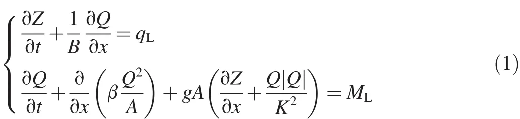
where Z is the cross-sectional water level,t is time,B is the channel width,Q is the river discharge,qLis the lateralflow discharge,β is the momentum coefficient,g is the gravitational acceleration,A is the cross-sectional area,K is theflow modulus,and MLis the momentum source term caused by lateralflow.
The 2D model component solving the 2D shallow water equations as follows is used to model lake hydrodynamics:
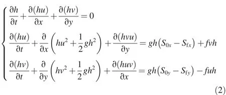
where h is the water depth;u and v are the depth-averaged velocities in the x-and y-directions,respectively;S0xand S0yare the bed slopes in the x-and y-directions,respectively;Sfxand Sfyare the friction slopes in the x-and y-directions,respectively;and f is the Coriolis coefficient.These 2D governing equations are solved using an unstructured Godunovtype finite volume method with the numericalfluxes calculated by an HLLC approximate Riemann solver(Toro,2009).
The CHAM-Yangtze model covers all the main rivers and lakes in the middle and lower parts of the Yangtze River Basin from the Yichang to Datong stations(Lai et al.,2013b).It has 14 1D and 2D inflow boundaries,15 lateral discharge boundaries,and one downstream outflow boundary.The 1D and 2D inflow or lateral discharge boundary conditions are specified by time series of measured discharge data.A stable rating curve is imposed at the downstream outflow boundary at the Datong Station,which is the furthest downstream hydrological station without the tide's influence.The effects of the operation of the TGD onflow regimes of downstream rivers and lakes can be examined easily by modifying the inflow boundary at the Yichang Station.
2.3.Floods in 1998 and 2010
In order to investigate the effects of the TGD on theflood level in Dongting Lake,two years were selected:1998,when the second largest Yangtze Riverflood of the past century occurred and the TGD was still under construction,and 2010,when the maximum discharge from the upper Yangtze River was larger than that in 1998 and the TGD was in operation for water storage.
In 1998,Dongting Lake was the most significantly affected area in the middle part of the Yangtze River Basin.On June 28,theflood level at the Chenglingji Station exceeded the warning water level(32.50 m).It broke the highestflood level record(35.31 m)on July 26 for the first time and then broke the record three additional times.Influenced by the flood water from the Lishui and Yuanjiang rivers and theflood peak from the upper reaches of the Yangtze River,theflood level at the Chenglingji Station reached the maximum water level of 35.94 m on August 20 and created a new historical record of the highest water level at the Chenglingji Station in Dongting Lake.From then on,theflood began to recess slowly and went under the warning water level on September 16.During thisflood event,theflood level at the Chenglingji Station was above the warning water level for 81 days(from June 28 to September 16),above the guaranteed water level for 45 days(from July 24 to September 6),and above the highest water level before 1998 for 29 days.
Theflood event in 2010 was the largest one since the beginning of operation of the TGD.In this year,the TGD was operated for water storage five times.Over 23 km3offlood water was regulated during this event.The third water storage occurred on July 20 to 22.By controlling the discharge from the TGD,the discharge decreased from 70000 m3/s(the maximum inflow)to 30000 m3/s(the maximum outflow).This resulted in a rise of the TGD's water level from about 150 m to 158 m.7.3 km3offlood water was stored during this time period.From July 28 to 30,the TGD was operated for water storage and the Yangtze River discharge downstream of the TGD decreased from 56000 m3/s to 40000 m3/s.Due to the operation of the TGD,theflood level in Dongting Lake remained stable in 2010.Theflood level at the Chenglingji Station was just slightly above the warning water level for about 16 days.
2.4.Modeling of TGD's effects
The TGD impoundment altered the river discharge to the lower Yangtze River.To analyze the TGD's effects on Dongting Lakefloods,we ran CHAM-Yangtze twice,setting the inflow boundary at the Yichang Station with and without theoperation oftheTGD and keeping othermodel parameters the same.The TGD's effects could be extracted quantitatively by comparing water levels at areas of interest.For the case of 1998,the Yichang inflow boundary condition was provided by the measured discharge hydrograph at the Yichang Station,in order to obtain theflood processes without operation of the TGD,and the regulated discharge was calculated by the reservoir operation guidelines under the 1998 upstream inflow discharge to the TGD,in order to obtain theflood processes with the operation of the TGD.In 2010,the TGD was operated to controlflooding.The Yichang inflow boundary condition was provided by the measured discharge hydrograph at the Yichang Station,in order to obtain theflood processes with the operation of the TGD,and the restored discharge from inflow to the Three Gorges Reservoir,in order to obtain theflood processes without the operation of the TGD.
3.Results
In our analysis,four main stations located in East,South,and West Dongting lakes were selected to show theflood level changes caused by the TGD in both 1998 and 2010.
The large amount offlood water from the upper Yangtze River was regulated by the TGD from June 11 to the end of September according to its formal operation guidelines.As a benefit of the TGD's flood storage,the flood peak in Dongting Lake can be significantly reduced(see Table 1).Our modeled results(Figs.2 and 3)with and without the operation of the TGD based on the 1998 and 2010flood events confirm this fact.As shown in Fig.2,most flood peaks during both years were cut significantly due to the operation of the TGD.For example,the highestflood peak at the Chenglingji Station appearing on August 20,1998,decreased from 35.92 m to 34.68 m with the operation of the TGD.Thisflood peak became the second highestflood peak in 1998.Similar to 1998,the highestflood peak at the Chenglingji Station would have reached 33.94 m in 2010 if the TGD were not in operation,appearing earlier and higher than the highestflood peak of 33.28 m measured on July 30,2010.

Table 1 Flood level reduction in 1998 and 2010 with TGD's operation(units:m).

Fig.2.Comparison offlood level hydrographs with and without operation of TGD in 1998.
From the changes of the entireflood season,we can see that there is little difference between large and mediumfloods.In 1998,theflood level at the Chenglingji Station,the outlet of Donting Lake,decreased by 0.43 m on average during the mainflood season from July to September.Almost the same reduction of about 0.30-0.40 m can be found at other stations(Table 1).This can mainly be attributed to the highflood level over the whole lake and low water surface slope during theflood season of 1998.The most significantflood level reduction at the Chenglingji Station reached 1.38 m at the time theflood peak reached its maximum.In 2010,the flood water level at the Chenglingji Station showed a slight increase of 0.07 m from July to September due to the operation of the TGD.This is mainly attributed to theflow homogenization throughout the flood season.However,the flood level reductions were still high in the days whenflood levels were above the warning water level.For example,the averageflood level reduction was 0.52 m at the Chenglingji Station during the days from July 19 to October 4.
In spite of the change inflood level,the operation of the TGD did not significantly reduce the number of days when theflood level was higher than the warning water level in most cases.However,the number of days when theflood level was above the highest safety level(34.55 m)was decreased significantly.In 1998,the duration above the highest safety levelwas shortenedbyabout10days(from 45to35days)when the TGD was operated.Due to the operation of the TGD,the timing of theflood peak was adjusted in some cases.For the 1998 large flood,the highestflood peak on August 20 became the second highest one,lower than the peak on August 7.In general,theflood process was attenuated due to the operation of the TGD.
Furthermore,examination of each peak for both years shows that some flood peaks are significantly reduced while the others have no significant changes.Fig.4 shows the flood level hydrograph,discharge from the upper reaches of the Yangtze River,and the inflow from the four main rivers in the Dongting Lake catchment.Comparison of the hydrographs confirms that the flood peak cannot be effectively reduced if it mainly arises fromflood water from the four main rivers.For the flood peak mainly induced by the flood water from the upper reaches of the Yangtze River,the TGD can play a significant role in cutting the flood peak in Dongting Lake.For example,during theflood event at the end of July in 1998,the TGD just lowered theflood level at the Chenglingji Station by 0.3 m.
4.Discussion
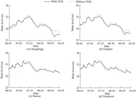
Fig.3.Comparison offlood level hydrographs with and without operation of TGD in 2010.

Fig.4.Comparison offlood level and discharge from four main rivers and Yangtze River in 1998 and 2010.
The TGD has a preservingflood capacity of about 22.15 km3(about 5%of the annual total runoff of the upper part of the Yangtze River Basin).It can reduceflood flow by 27000-33000 m3/s.The operation of the TGD can lead to a change in flood processes,including the timing and magnitude of theflood peak in Dongting Lake.If appropriately operated,it will be very helpful in the alleviation of potentialflood disasters.The pressure offlood prevention in the lake area will be greatly mitigated with the TGD's operation.
However,the effects of TGD operation are still limited.Although no largefloods occurred in the lake since the beginning of operation of the TGD in 2003,this does not mean thatflood risk has been eliminated by the TGD together with otherflood control measures at present.Climate variability may cause new largefloods like the 1954 and 1998floods.Our 1998 results show that the significantflood damage caused by largefloods cannot be totally avoided by means of the operation of the TGD alone.Therefore,a comprehensive strategy forflood management in Dongting Lake still needs to be considered.
Dongting Lake receives over half of itsflood water from the four main rivers during the flood season.The flood control measures in its own catchment also play an important role.Currently,there are eight controlling reservoirs with a total storage capacity of 13.09 km3.These reservoirs can be fully used to preventfloods arising from the four main rivers in the catchment.
Through flood waterstorage using these reservoirs,including the Three Gorges Reservoir,flood peaks in Dongting Lake can be decreased significantly.Fully utilizing the flood storage capacity of these reservoirs is a challenge,though.As we know,the large and disastrousfloods in Dongting Lake are mainly caused by theflood combined effects and interactions of the Yangtze River and the four main rivers of the catchment(Dou and Jiang,2000;Zong and Chen,2000).Accurate operation of the reservoirs can effectively causeflood peaks to shift and then reduce the peak value.In contrast,operation without full consideration may be a disaster for this complex river-lake system.Thus,to make full use of the present reservoirs,aflood warning system including reservoir operation is mandatory.An accurate hydrodynamic model will be a key component of it.
Along with operation of reservoirs,comprehensiveflood management measures in the catchment should be taken to homogenizeflood processes,in order to reduce theflood risk over different spatial scales.There are some valuable and sustainable strategies that can be applied.For example,the Natural Flood Management(Wentworth,2011)seeks to reduce theflood risk by utilizing or restoring natural processes through the so-called soft engineering,which means engineering with natural materials,such as soil.The Sponge City Program proposed recently in China also seeks a way to holdflood water and mitigate urban flooding.Combing all these measures throughout the catchment may have a surprising effect in reducing theflood risk.In fact,sustainable measures forflood risk reduction would not be new to Dongting Lake.After the majorflooding of 1998,many lands(polders)originally cultivated from lake wetlands in previous decades were returned to the lake.These restored wetlands can storeflood water and reduce theflood peak to some extent.Through examination of theflood responses to the lake restoration from different polders,Jiang et al.(2007)suggested the strategy of restoration of polders to a lake,which helps maximize the reduction offlood disasters.
Previous studies have also shown that over tens of cubic kilometers of excessflood water should be stored elsewhere when a 1954-levelflood occurs,without the operation of the TGD(HESC,2002).We need tofind new places to storeflood water.An alternative method would be to introduce new water storage areas,for example,further expanding lake wetland areas or constructing new reservoirs in lake areas that can absorb the highflood risk.Otherwise,improved management is required for lake wetlands and cultivated lands,especially the lands used forflood retention.The low river embankment can be heighted and reinforced.Alternative measures can be considered,however,including the immigration fromfloodprone areas,and the construction of houses and buildings in highlands that have a low risk of inundation.
5.Conclusions
Using the CHAM-Yangtze model,we modeled theflood level changes of the 1998 and 2010flood events in Dongting Lake caused by the operation of the TGD.The hydrodynamic model can accurately reproduce theflood routing processes.It can help to identify the causes, development, and consequences of aflood event,and also to evaluate the effects of possibleflood control measures onflood routing processes.At the same time,as a physical law-based model,it can be used in aflood warning system to provide a more accurate forecast forflood routing in a complex system like Dongting Lake.
Quantitative comparison of theflood level changes in bothflood years show that the operation of the TGD can effectively reduce theflood peak mainly caused by flood water from the Yangtze River.The TGD alone cannot eliminateflood disasters related to largeflood events,but can mitigate them partially.To prevent potentially significant flood disasters,comprehensiveflood management is necessary.
D'Alpaos,L.,Defina,A.,2007.Mathematical modeling of tidal hydrodynamics in shallow lagoons:A review of open issues and applications to the Venice lagoon.Comput.Geosci.33(4),476-496.https://doi.org/10.1016/j.cageo.2006.07.009.
Dou,H.S.,Jiang,J.H.,2000.Dongting Lake.Press of University of Science and Technology of China,Hefei(in Chinese).
Du,Y.,Cai,S.M.,Zhang,X.Y.,Zhao,Y.,2001.Interpretation of the environmental change of Dongting Lake,middle reach of Yangtze River,China,by210Pb measurement and satellite image analysis.Geomorphology 41(2-3),171-181.https://doi.org/10.1016/S0169-555X(01)00114-3.
Fang,H.W.,Han,D.,He,G.J.,Chen,M.H.,2012.Flood management selections for the Yangtze River midstream after the three Gorges project operation. J. Hydrol. 432-433, 1-11. https://doi.org/10.1016/j.jhydrol.2012.01.042.
Hartmann,H.,Becker,S.,Jiang,T.,2012.Precipitation variability in the Yangtze River subbasins.Water Int.37(1),16-31.https://doi.org/10.1080/02508060.2012.644926.
Hu,C.H.,Fang,C.M.,Cao,W.H.,2015.Shrinking of Dongting lake and its weakening connection with the Yangtze River:Analysis of the impact onflooding.Int.J.Sediment Res.30(3),256-262.https://doi.org/10.1016/j.ijsrc.2014.05.001.
Huang,Q.,Sun,Z.D.,Opp,C.,Lotz,T.,Jiang,J.H.,Lai,X.J.,2014.Hydrological drought at Dongting lake:Its detection,characterization,and challenges associated with three Gorges Dam in central Yangtze,China.Water Resour.Manag.28(15),5377-5388.https://doi.org/10.1007/s 11269-014-0807-8.
Hunan Economic and Scientific Committee(HESC),2002.Relationship between the Three-gorges Project and Dongting Lake.Hunan Science and Technology Press,Changsha(in Chinese).
Jiang,J.H.,Lai,X.J.,Qun,H.,2007.The characteristics offlood responses to the restoration of polders on Dongting Lake,China.Hydrol.Sci.J.52(4),671-685.https://doi.org/10.1623/hysj.52.4.671.
Lai,X.J.,Jiang,J.H.,Huang,Q.,2013a.Effects of the normal operation of the Three Gorges Reservoir on wetland inundation in Dongting Lake,China:A modelling study.Hydrol.Sci.J.58(7),1467-1477.https://doi.org/10.1080/02626667.2013.831418.
Lai,X.J.,Jiang,J.H.,Liang,Q.H.,Huang,Q.,2013b.Large-scale hydrodynamic modeling of the middle Yangtze River Basin with complex riverlake interactions.J.Hydrol.492,228-243.https://doi.org/10.1016/j.jhydrol.2013.03.049.
Lai,X.J.,Jiang,J.H.,Yang,G.S.,Lu,X.X.,2014.Should the Three Gorges Dam be blamed for the extremely low water levels in the middle-lower Yangtze River? Hydrol.Process.28(1),150-160.https://doi.org/10.1002/hyp.10077.
Li,Y.T.,Sun,Z.H.,Liu,Y.,Deng,J.Y.,2009.Channel degradation downstream from the Three Gorges Project and its impacts onflood level.J.Hydraul.Eng.135(9),718-728.https://doi.org/10.1061/(ASCE)0733-9429(2009)135:9(718).
Paiva,R.C.D.,Collischonn,W.,Tucci,C.E.M.,2011.Large scale hydrologic and hydrodynamic modeling using limited data and a GIS based approach.J.Hydrol.406(3-4),170-181.https://doi.org/10.1016/j.jhydrol.2011.06.007.Paz,A.R.,Bravo,J.M.,Allasia,D.,Collischonn,W.,Tucci,C.E.M.,2010.Large-scale hydrodynamic modeling of a complex river network andfloodplains.J.Hydrol.Eng.15(2),152.https://doi.org/10.1061/(ASCE)HE.1943-5584.0000162.
Su,B.D.,Jiang,T.,Jin,W.B.,2006.Recent trends in observed temperature and precipitation extremes in the Yangtze River basin,China.Theor.Appl.Climatol.83(1-4),139-151.https://doi.org/10.1007/s00704-005-0139-y.Toro,E.F.,2009.Riemann Solvers and Numerical Methods for Fluid Dynamics:A Practical Introduction.Springer-Verlag Berlin,Heidelberg.
Wentworth,J.,2011.Natural Flood Management(No.POSTNote 396).Parliamentary Office of Science and Technology,London.
Yin,H.F.,Liu,G.R.,Pi,J.G.,Chen,G.J.,Li,C.G.,2007.On the river-lake relationship of the middle Yangtze reaches.Geomorphology 85(3-4),197-207.https://doi.org/10.1016/j.geomorph.2006.03.017.
Zhang,Q.,Xu,C.Y.,Zhang,Z.X.,Chen,Y.D.,Liu,C.L.,Lin,H.,2008.Spatial and temporal variability of precipitation maxima during 1960-2005 in the Yangtze River basin and possible association with large-scale circulation.J.Hydrol.353(3-4),215-227.https://doi.org/10.1016/j.jhydrol.2007.11.023.
Zhou,G.,Wang,H.,Shao,X.J.,Jia,D.D.,2009.Numerical model for sediment transport and bed degradation in the Yangtze River channel downstream of Three Gorges Reservoir.J.Hydraul.Eng.135(9),729.https://doi.org/10.1061/(ASCE)0733-9429(2009)135:9(729).
Zong,Y.Q.,Chen,X.Q.,2000.The 1998flood on the Yangtze,China.Nat.Hazards 22(2),165-184.https://doi.org/10.1023/A:1008119805106.
杂志排行
Water Science and Engineering的其它文章
- Preface for special section on flood modeling and resilience
- Fenton-like oxidation of azo dye in aqueous solution using magnetic Fe3O4-MnO2nanocomposites as catalysts
- Preparation of 2D square-like Bi2S3-BiOCl heterostructures withenhanced visible light-driven photocatalytic performance for dye pollutant degradation
- Effects of urban grass coverage on rainfall-induced runoff in Xi'an loess region in China
- Effect of water-sediment regulation and its impact on coastline and suspended sediment concentration in Yellow River Estuary
- A distributed eco-hydrological model and its application