Numerical simulation of groundwater and early warnings from the simulated dynamic evolution trend in the plain area of Shenyang, Liaoning Province (P.R. China)
2016-11-25LIUJunqiuXIEXinmin
LIU Jun-qiu, XIE Xin-min
1Department of Water Resources, China Institute of Water Resources and Hydropower Research, Beijing 100038, China.
2College of Hydrology and Water Resources, Hohai University, Nanjing, 210098, China.
Abstract: Groundwater level is the most direct factor reflecting whether groundwater is in a virtuous cycle. It is the most important benchmark for deciding whether a balance can be struck between groundwater discharge and recharge and whether groundwater exploitation will trigger problems pertinent to environment, ecology and environmental geology. According to the borehole and long-term monitoring wells data in the plain area of Shenyang, a numerical groundwater model is established and used to identify and verify the hydrogeological parameters and balanced items of groundwater. Then the concept of red line levels, the control levels of groundwater is proposed, the dynamic evolution trend of groundwater under different scenarios is analyzed and predicted and groundwater alerts are given when groundwater tables are not between the lower limit and the upper limit. Results indicated: (1) The results of identification and verification period fitted well, and the calculation accuracy of balanced items was high; (2) with the implementation of shutting wells, groundwater levels in urban areas of Shenyang would exceed the upper limit water level after 2020 and incur some secondary disasters; (3) under the recommended scenario of water resources allocation, early-warnings for groundwater tables outside the range would occur in the year of 2020, 2023, 2025 respectively for successive wet, normal and dry years. It was imperative to reopen some groundwater sources and enhance real-time supervision and early-warning to prevent the occurrence of potential problems.
Keywords: Groundwater table; Groundwater exploitation; Numerical modeling of groundwater; Plain area of Shenyang
Research background
With the influence of the ongoing global climate change and anthropogenic actions, many areas, both home and abroad, rely on groundwater overdraft to meet the rapid increasing water demand so as to maintain rapid socioeconomic development given the undersupply of surface water resources. Yet groundwater overdraft has led to a series of problems pertinent to resources,ecology and environmental geology. Since 1960s,many scholars, both home and abroad, have begun studying on the technology of numerical simulation of groundwater (XUE Li-juan et al. 2010;McDonald M G et al. 1988; Anon, 2000a,b; HE Guo-ping et al. 2003) and applying the technology for work including dynamic simulation of groundwater as well as assessment, planning and management, yielding productive achievements.Based on groundwater management and the actual demand that production requires, domestic scholars have been paying more attention to using the simulation software developed by domestic developers alone or common simulation software to tackle issues including assessing groundwater resources (GONG Ai-xi, 2011; YANG Guo-li et al.2014; SHI Jian-sheng et al. 2014), adopting exploitation plans (XIAO Chang-lai et al. 2007;ZHU Xiao-bin et al. 2005; MA Lan, 2009) and deciding control levels and thresholds for groundwater management (FANG Zhang et al.2014). In 2012, Opinions on Implementing the Stringent Water Resources Management System,the No. 3 Document issued by the State Council,clearly stated that total groundwater extraction and water level control would be adopted for the state’s groundwater management. Although the concept of the “two-pronged control” of the total groundwater extraction and water levels has taken shape,currently, there is no uniform technical standard for regulations on and the guidance to the“two-pronged control” of the total groundwater extraction and water levels (FANG Zhang et al.2013). Hence, based on different groundwater exploitation and utilization in different areas, the plan of shutting wells to reducing groundwater exploitation in particular, is of great importance and urgency to appropriately decide and adjust the exploitation layout and scale on the basis of the forecasted dynamic evolution trend of groundwater by using the numerical model of groundwater so as to ensure a virtuous cycle and sustainable utilization of groundwater.
With the plain area of Shenyang, an old industrial base of northern China, as an example,based on investigations and analysis on hydrogeological conditions and groundwater exploitation and utilization in this area, the GMS software is applied to build the numerical model of groundwater, the concept of red line levels is introduced as the control levels of groundwater, analysis and predictions of the dynamic evolution trend of groundwater under shutting wells and the adjusted water resources allocation scenario are made, early warnings for areas and years whose groundwater levels would be outside the range were obtained,which would provide sound basis for implementing the “two-pronged control” of the total groundwater extraction and water levels.
1 Overview
Shenyang is situated in the southern portion of the Northeastern China, the central portion of Liaoning Province and Liaohe Plain with an annual precipitation of 598.9 mm and a total amount of water resources reaching 2.378 billion m3. The plain area of Shenyang includes five urban districts(Heping District, Shenhe District, Dadong District,Huanggu District and Tiexi New District) and four suburban districts (Shenbei New District, Sujiatun District, Hunnan New District, and Yuhong District). The total floor space of the plain area is 2 318 km2. The groundwater of the plain area is mainly pore phreatic water and urban groundwater supply sources are concentrated with high exploitation intensity, so some funnel-shape depression areas have formed. The maximum drawdown of groundwater in the center of the cone of depression reaches 20.7 m.
2 Specification of the hydrogeological conceptual model
2.1 Conceptualization of the aquifer and boundary conditions
(1) Conceptualization of the Aquifer. Basically,it can be concluded that from the top down aquifer grain granularity changes from fine to coarse. The upper part includes medium-sized coarse sand with gravel, coarse sand, medium sand and fine sand;the lower part includes gravel or gravel with soil.As the thickness and lithology within the area show changes to different extents, the aquifer is conceptualized as a heterogeneous and isotropic one. As the groundwater flow field is relatively flat,which is consistent with Darcy’s law, it is conceptualized as a two-dimensional or quasi three-dimensional unsteady flow.
(2) Conceptualization of Boundary Conditions.a) Conceptualization of lateral boundary conditions:the eastern boundary of the aquifer borders on mountainous areas and there is lateral recharge from the mountainous areas. The boundary is a lateral recharge boundary. Northern and southern boundaries converge with rivers; they are boundaries with a constant water level. The western boundary exchanges water with neighboring regions; the boundary is primarily a lateral discharge boundary. b) Conceptualization of vertical boundary conditions: Aquifer’s precipitation infiltration and surface water infiltration, canal irrigation infiltration, well irrigation regression recharge and lateral recharge are recharges.Groundwater exploitation, lateral discharge and phreatic evaporation are discharges. Aquifer floor is the impervious boundary because it is contact with the bedrock.
2.2 Parameter partitions and initial value determination
According to Shenyang’s regional hydrogeological prospecting and borehole data, the plain area was divided into 8 hydrogeological parameter partitions. Specific information is displayed in Fig. 1.Initial values for aquifer permeability coefficient and specific yield were comprehensively determined based on field pumping test data and empirical value. Comparative results between initial values and recommended values after the model identification and verification of parameters are shown in Table 1.
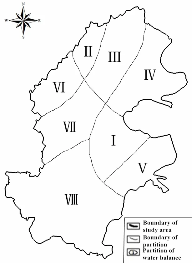
Fig. 1 Hydrogeological parameter partitions in the plain area of Shenyang

Table 1 Comparative results between initial values and recommended values of parameters
3 Numerical modeling of groundwater and its identification and verification
3.1 Model specification and solutions
Based on the specified hydrogeological conceptual model, the mathematical model was established as follows (Rao G T et al. 2013):

where: K is the aquifer permeability coefficient(m/d), μ is the specific yield; H is the groundwater level (m); h0is the initial water level (m); B is aquifer floor elevation (m); Qris the recharge volume (m3/d); Qdis the discharge volume (m3/d);Qiis the groundwater extraction from the largediameter well (m3/d); h1is the Type I boundary water level (m); q is the type II boundary unit discharge (m3/d/m);x, yare coordinates (m); D is the area for computation;nis the interior normal to the boundary;Γ1,Γ2are Type I and II boundaries respectively.
Rectangular partition and linear interpolation were used on the computation area D by GMS software. Kriging’s finite difference method was used to convert the above mathematical model into discrete finite equations. Solutions were obtained through the computer program.
3.2 Model identification and verification
Model identification was carried out by using a series of observed data from April 26th, 2007 to April 26th, 2013. Model verification was carried out by using a series of observed data from April 26th, 2013 to September 26th, 2013. Calculations are conducted on a monthly basis. Major identification and verification results are shown in Table 1,Table 2, Fig. 2 and Fig. 3.
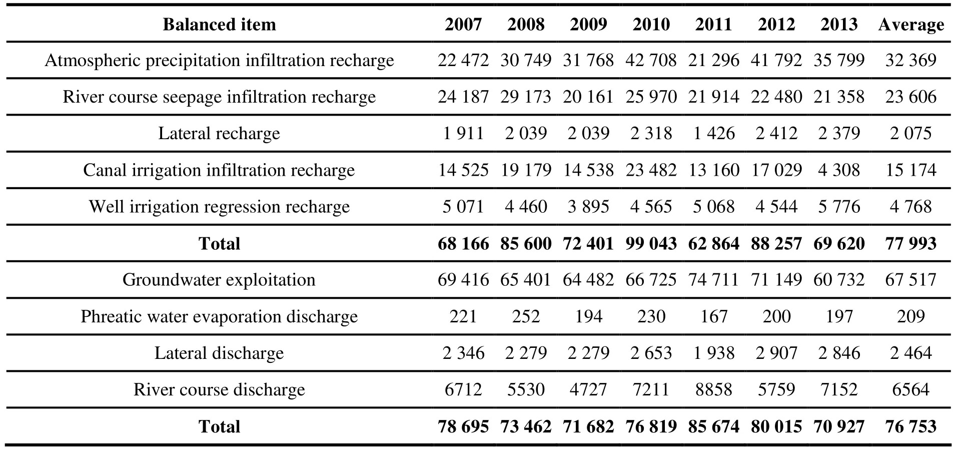
Table 2 Calculated results of groundwater balanced items (2007-2013) unit:10 thousand m3
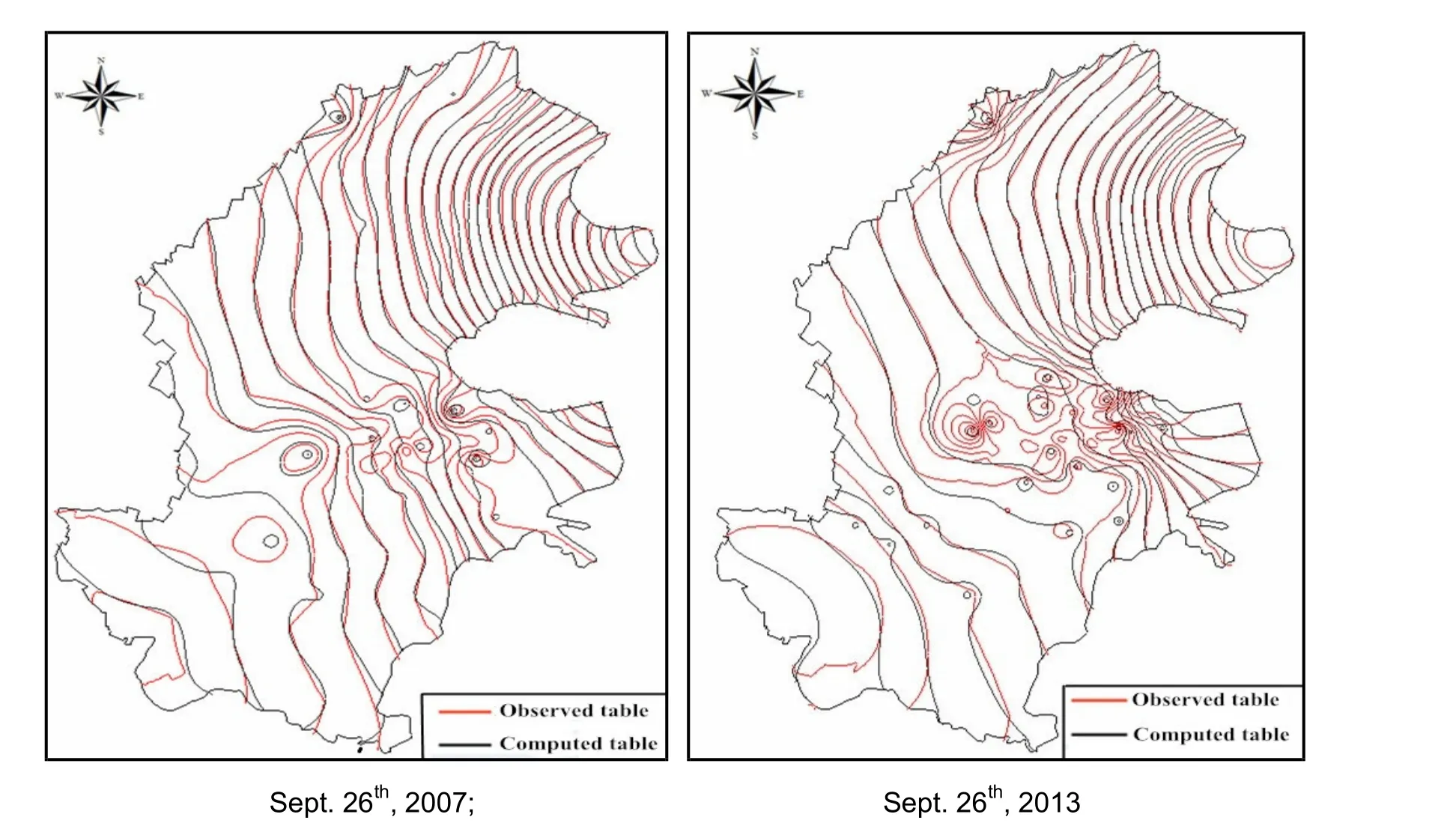
Fig. 2 Contour maps of groundwater water levels fitting between the initial phase of identification and the last phase of verification
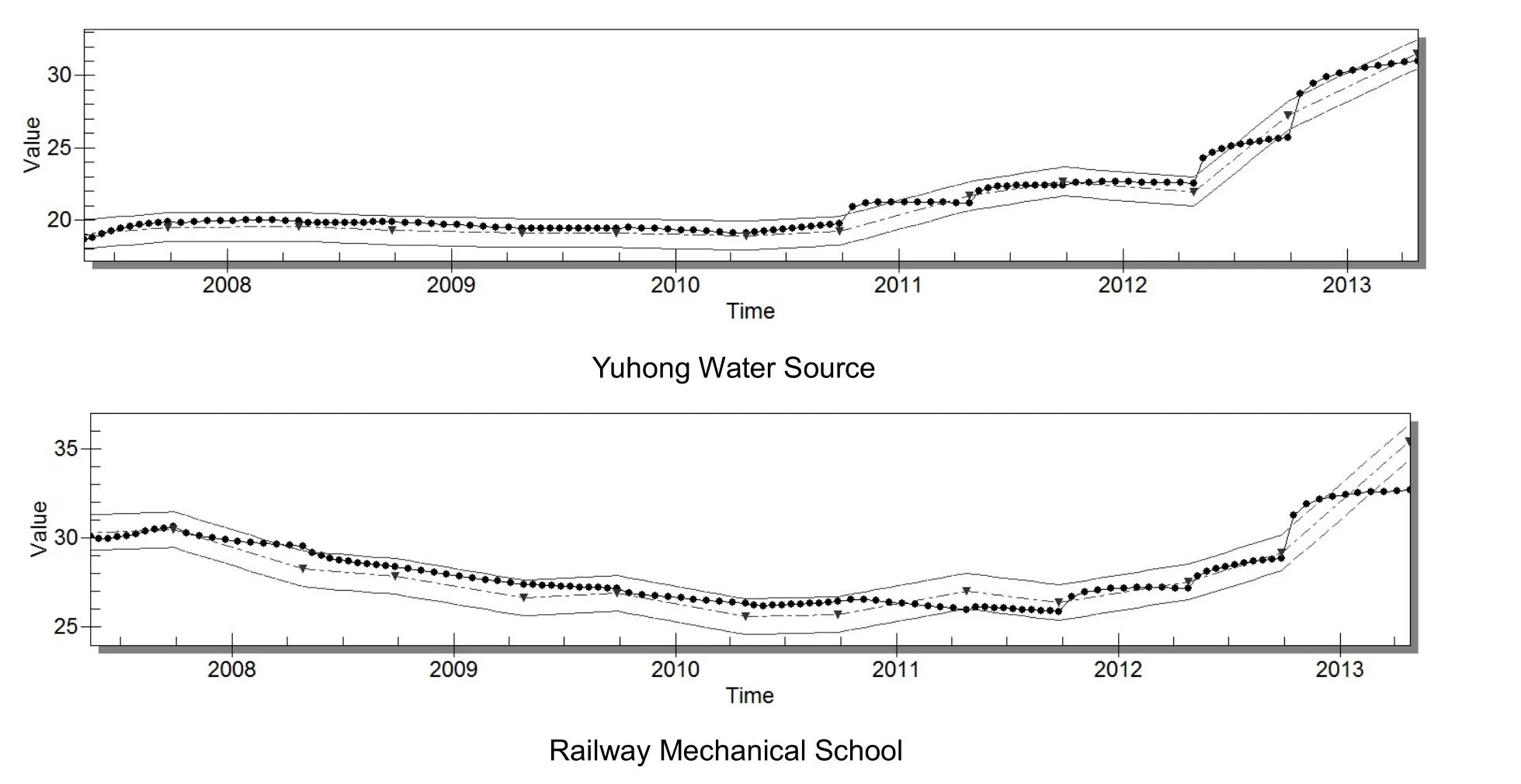
Fig. 3 Contour maps of some long term monitoring wells’ water levels fitting
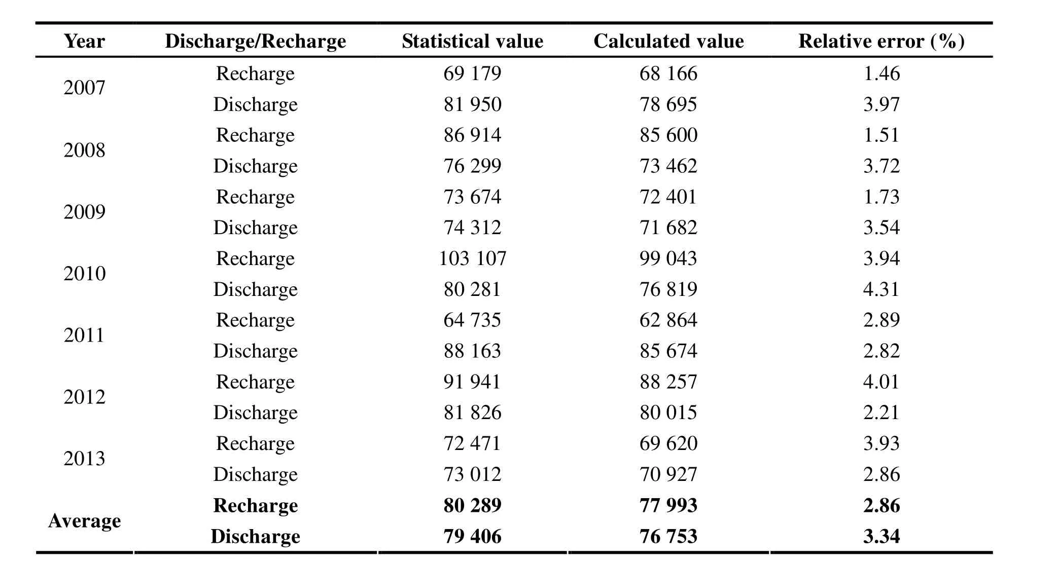
Table 3 Comparative results between calculated results of the model and statistical values through water resources investigation sand assessments (unit:10 thousand m3)
Based on the fitting errors of water levels,computation nodes with calculated errors below 1 m accounted for more than 85% of the total;computation nodes with calculated errors below 0.5 m accounted for more than 75% of the total.With the influence of concentrated groundwater exploitation in Shenyang urban areas (five urban districts) and discharge from railway construction and underground buildings, the dynamic distribution of groundwater in the five urban districts was complex so the model did not fit well. While with little influence of the aforementioned factors, the dynamic distribution of groundwater in four suburban districts was basically regular so the model fitted well. To conclude, the identified and verified model can be used for quantitating and forecasting the dynamic future trend of groundwater.
In order to further evaluate and check the accuracy of the model, modeling discharges and statistical values through investigations and assessments of water resources within identification and verification periods were compared. Table 3 displays the results.
According to the comparative results in Table 3,model-simulated values were 1.46%-4.31% smaller than statistical values with averaged recharge 2.9%being smaller than statistical values and averaged discharge 3.3% smaller than statistical values.Therefore, it can be concluded that the accuracy of the model was reliable and accuracy requirement was met (generally (-5%, 5%)).
The GMS was used for simulating and verifying models of different aquifer groundwater in the complex multi-aquifer systems with a high goodness of fit (Gurwin J and Lubczynski M,2005). Numerical models were applied to agricultural water management and conducted groundwater numerical simulation with a high goodness of fit (ZHAO Cheng-yi et al. 2005; HUO Zai-lin et al. 2007). However, this paper not only studies model identification and specification but also provides error analysis by comparing the modeling results to statistical results from water resources investigations and assessments. The purpose of the paper is to apply the numerical model of groundwater and discuss environmental problems resulting from overdraft-incurred water table falls,provide early warnings for water levels and put in place the control plan so as to provide a sound basis and guarantee for two-pronged management of groundwater resources.
4 Red line levels as the control levels of groundwater
4.1 Basic concept
For different hydrogeological units, red line levels as the control levels of groundwater are referred to as critical water levels resulted from water levels changes, which might incur a host of problems pertinent to resources, ecology and environmental geology. They are a set of critical values or thresholds solely used as indexes for the regional hydrogeological conditions and potential disasters pertinent to various resources, ecology and environmental geology. They have little impact on national economy, water resources allocation or management objectives. On the one hand, groundwater overdraft can result in a significant decline in regional groundwater levels,cause disasters including land subsidence, ground fissures and land subsidence, vegetation natural death, deterioration of water quality. On the other hand, surface water can raise regional groundwater tables, causing problems including secondary soil salinization, swamping and road mud squeezing.However, the concept of red line levels has been seldom studied at home and abroad, and most researches proposed the concept of critical water levels. For instance, for the North China Plain, the Sanjiang Plain and the Heihe River Basin(ZHANG Chang-chun et al. 2003; SUN Xiang-tai et al. 2012; FENG Qi et al. 2012), ecological groundwater levels were adopted for giving a full play to groundwater for regulating the ecological environment, which means groundwater levels could meet the requirements that would not lead to deterioration of the ecological environment. A preliminary study of critical groundwater levels was conducted as the control levels of groundwater and proposed that critical groundwater levels are referred to the groundwater levels affected by exploitation and utilization (XIE Xin-min et al.2007). Thus, for a host of problems pertinent to resources, ecology and environmental geology incurred by the “incomplete” groundwater circulation, this paper, based on the most stringent water management system and the “three red lines”system, proposes the concept of groundwater red water levels. “Red lines” mean the warning lines for further groundwater table rises or falls, and consequently, red lines are classified into the upper limit water levels and the lower water levels from aforementioned aspects. Through comparing the groundwater level with the water level range, it can be decided that whether the groundwater level is in a good condition; consequently with the established level-quantity model adjusting groundwater exploitation, the reasonable groundwater level can be obtained. That is why this paper proposes the concept of red line levels as the control levels of groundwater.
4.2 Analysis results
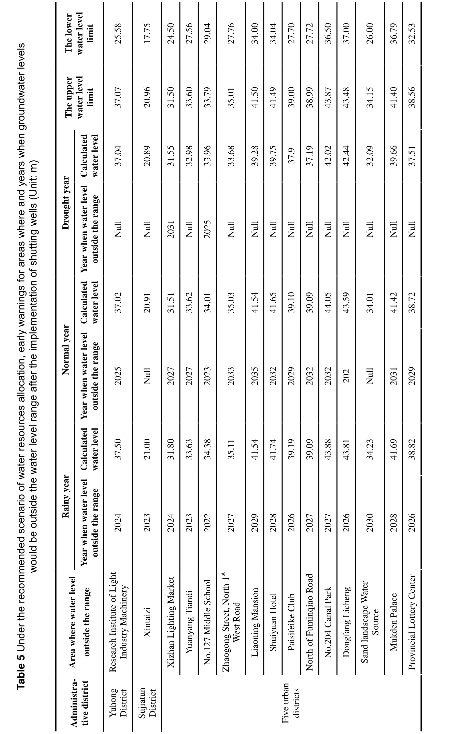
Based on regional hydrogeological conditions,long-term monitoring data of groundwater, soil secondary salinization, swamping, road mud squeezing as well as critical water levels for ground subsidence, ground fissures and deterioration of water quality and designed water levels for anti-floating and waterproof underground structures of different hydrogeological units, red line levels as the control levels of groundwater of the plain area of Shenyang were comprehensively determined. The main results are shown in Table 4 and Table 5.
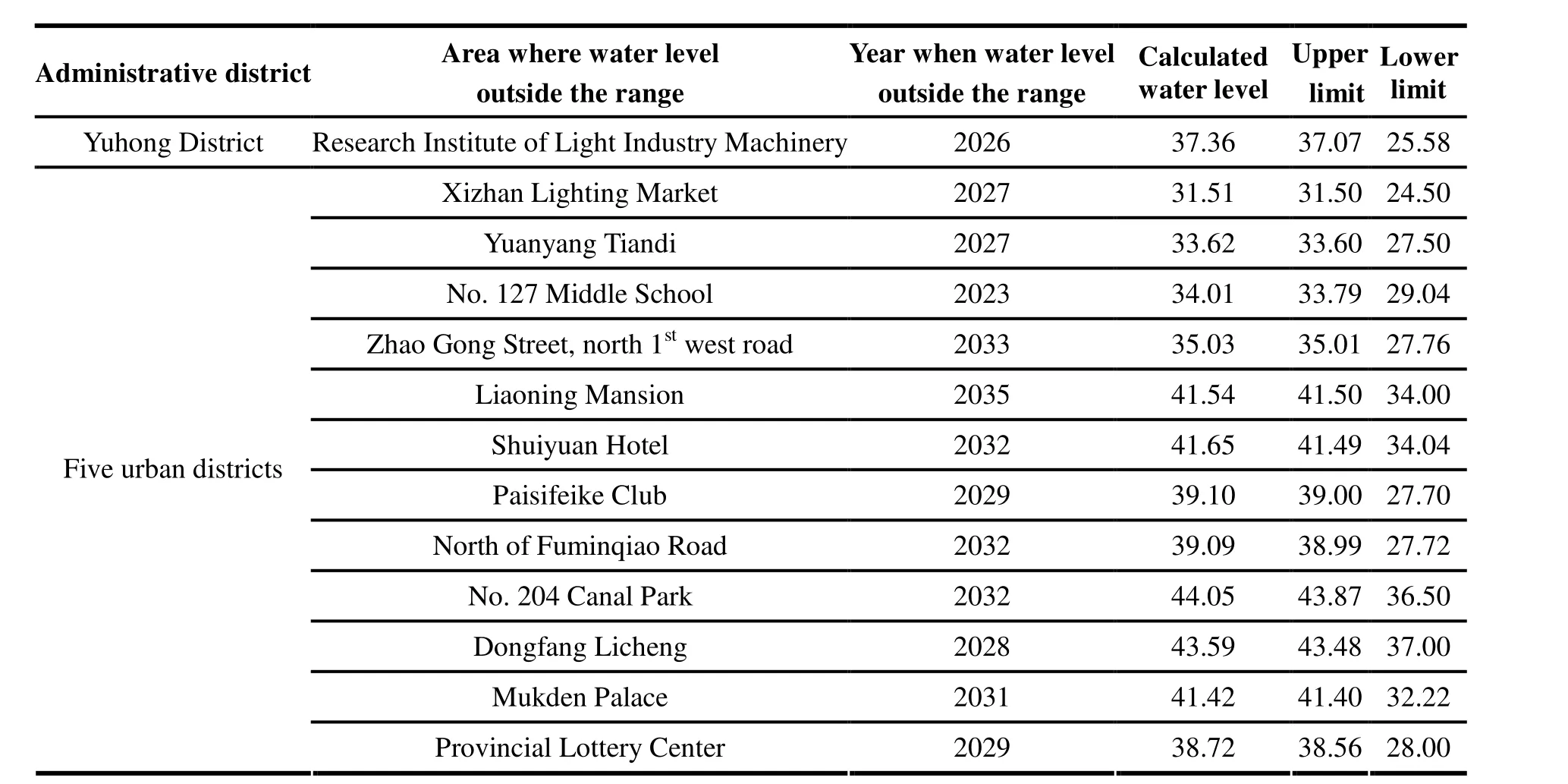
Table 4 Under the status quo scenario of water resources allocation early-warnings for areas where and years when groundwater levels would be outside the water level range after the implementation of shutting wells (a multi-year average) unit: m
5 Alert results of the dynamic trend of groundwater under different scenarios
Based on plan of shutting wells of Shenyang,under the status quo and recommended scenario of water resources, the dynamic evolution trend of groundwater from 2014 to 2035 was analyzed and predicted; through comparing the groundwater level with red line levels, early warnings for areas where and years when groundwater levels would be outside the water level range in the future were provided so potential problems could be discovered and prevented at an early date. Results are shown in Table 4 and Table 5.
Table 4 and Table 5 show that under the status quo and recommended scenario of water resources allocation on a multi-year average basis, after the implementation of shutting wells, areas where groundwater levels would be outside the water level range all included No. 127 Middle School,Research Institute of Light Industry Machinery,Xizhan Lighting Market, Yuanyang Tiandi and Dongfang Licheng and so on; years when groundwater levels would be outside the range included 2023, 2026, 2027, 2027, 2028 and 2023,2025, 2027, 2027, 2028 respectively and beyond.These indicated that there would be significant water level rises for areas around water supply sources after the implementation of shutting wells,and that a series of secondary disasters could be brought about in the future.
The best way to prevent the potential secondary disasters taking place in regional Shenyang urban area after shutting wells is to reopen the already shutting groundwater supply source. Under the recommended scenario of water resources allocation, putting the adjusted groundwater exploitation into the numerical model of groundwater, the best programs for groundwater supply in the year of 2020 and 2030 in Shenyang urban areas were determined through multiple iterative computation.Fig. 4 displays the dynamic evolution trend of groundwater.
?
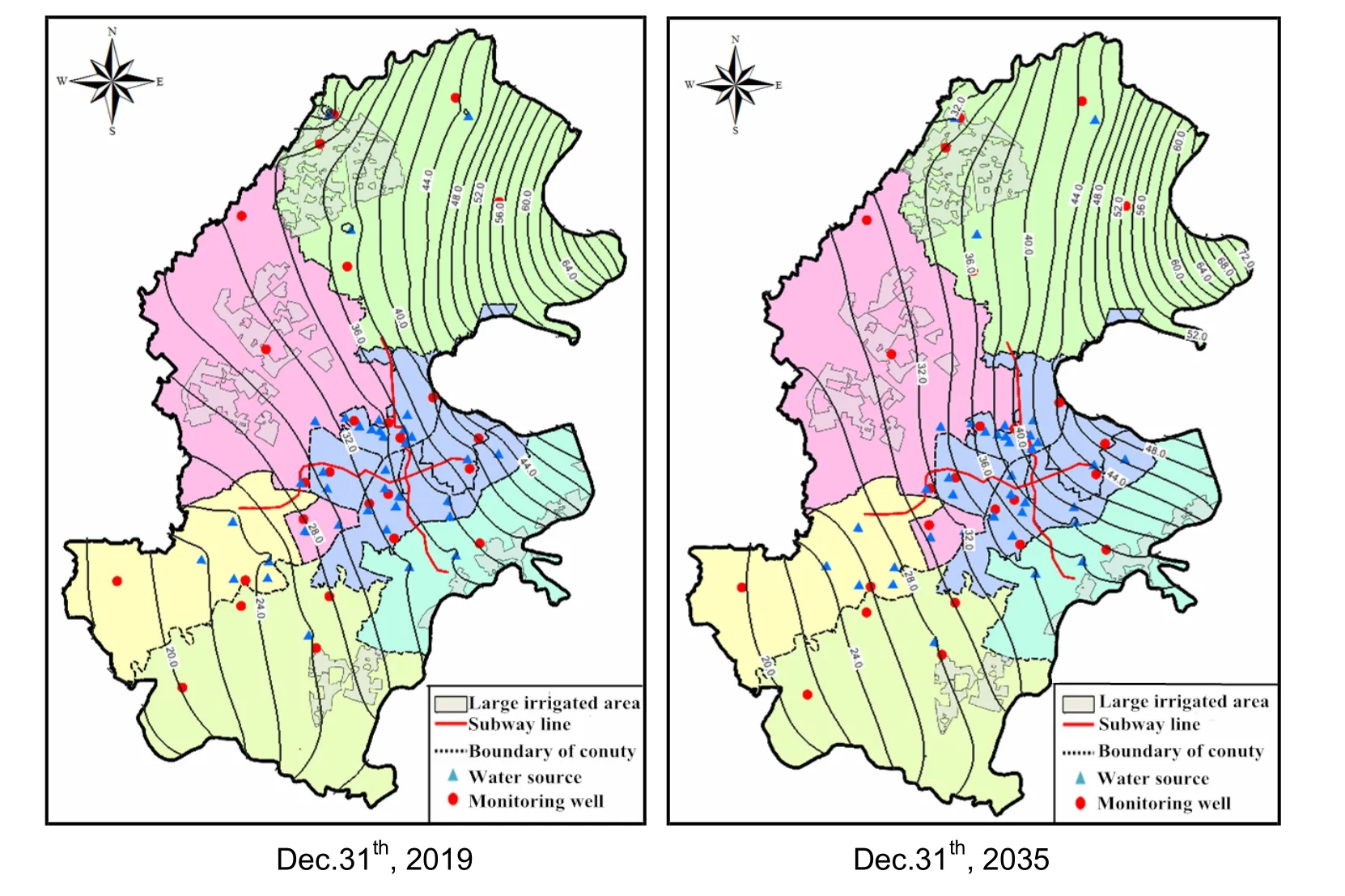
Fig. 4 Contour maps of groundwater levels under the recommended scenario after reopening groundwater water supply sources
6 Conclusions and suggestions
To address the potential problems from reduced groundwater exploitation in Shenyang, this paper proposes the concept of red line levels as the control levels of groundwater, specifies the numerical model of groundwater and predicts the dynamic evolution trend of groundwater under different scenarios by controlling groundwater exploitation,decides whether secondary disasters will occur in the future by comparing groundwater levels with red line levels and provides early warnings, which will provide a sound basis for ensuring water resources safety and adopting the “two-pronged control” of groundwater in Shenyang.
The red line level is the best benchmark for assessing and deciding whether groundwater is in a virtuous cycle. On the one hand, groundwater overdraft can lead to continuing decline of water level, which might incur some secondary disasters.On the other hand, after shutting wells, water table will rise quickly, which also might trigger some environmental and geological problems. Thus, it is imperative to adopt the “two-pronged control” and appropriate red line levels as the control levels of groundwater. Therefore, putting the adjusted groundwater exploitation into the numerical model of groundwater, the results of water resources allocation based on red line levels can be obtained through multiple iterative computations. At the same time, the best plan for the “two-pronged control” of groundwater including groundwater exploitation and water levels can be obtained as well.
The groundwater system is a giant and complex system for groundwater’s movement, evolution,input and out. As time goes by after shutting wells,under the influence of changes in regional geology,climate, rivers, hydrogeology and aquifer structures,some changes will take place in the relationship between groundwater recharge and discharge, and consequently, in hydrogeological parameters. For instance, Asian’s groundwater system was divided into 36 sub-regions and discussed the long-term evolving characteristics of each sub-region’s geology, climate, rivers, hydrogeology and aquifer structures, which provided a sound basis for groundwater exploitation and management with the changing hydrogeological conditions (ZHANG Fa-wang et al. 2016). In light of the complexity of the practical problems and problems during model conceptualization, it is recommended that calibration and validation of the numerical model of groundwater should be carried out on a regular basis so as to ensure its accuracy. Based on model forecasts, real-time and early-warning monitoring of groundwater should be strengthened so potential problems incurred by reducing groundwater exploitation can be discovered at an early date and reliable evidence can be provided for safeguarding safety of urban water supply and ecological environment.
Acknowledgements
This study is supported by Program of Separated Water Resources Fees of the Central government (1261530110043).
杂志排行
地下水科学与工程(英文版)的其它文章
- Building a scientific and ecological earth-on an important field of geo-science: Geo-environment and construction engineering effect
- A discussion of up-flow springs
- Statistical characteristics of heavy metals content in groundwater and their interrelationships in a certain antimony mine area
- Thermal stresses analysis of casing string used in enhanced geothermal systems wells
- Groundwater resources in karst area in Southern China and sustainable utilization pattern
- Study on engineering-hydrogeological problems of hydroelectric project
