Simulation of groundwater level recovery in abandoned mines, Fengfeng coalfield, China
2016-11-25MALuanWANGGuangcaiSHIZhemingGUOYuyingXUQingyuHUANGXujuan
MA Luan, WANG Guang-cai,2*, SHI Zhe-ming,2, GUO Yu-ying, XU Qing-yu, HUANG Xu-juan
1School of Water Resources and Environment, China University of Geosciences, Beijing 100083, China.
2State Key Laboratory of Biogeology and Environmental Geology & MOE Key Laboratory of Groundwater Circulation and Evolution, China University of Geosciences, Beijing 100083, China.
Abstract: Abandoned mines are of high potential risk as they could be a large underground storage of pollutants (heavy metals and organic wastes, etc.). Various physical, chemical and biological reactions would take place when groundwater flows into underground spaces, which makes abandoned mine a huge potential hazard to groundwater environment. The recovery of groundwater level is one of the key elements controlling the reactions and causing such hazards.This paper simulated groundwater level recovery processes in the abandoned mines, Fengfeng coalfield by using the computer program FEFLOW. The paper integrated the pipe flow model,“three zones” model and groundwater inrush (discharge) model in the simulation of groundwater in the complex laneway-aquifer system. Groundwater flow in the laneway systems was considered pipe flow and described in Bernoulli equation. The water-bearing medium (coal seam roof) overlying the laneway systems was divided into “three zones”composed of the caving zone, fissure zone and bending zone based on the disruption degrees of previous mining. Groundwater in the Ordovician limestone aquifer (bottom of coal seam)flowing into laneway systems was considered a major inrush/recharge source, and its flow rate was calculated by an inrush (discharge) model which was newly developed in this study and incorporated into FEFLOW. The results showed that it would take approximately 95 days for groundwater in abandoned mines to recover to regional groundwater level elevation, and the total amount of water filling up would be about 1.41195×10⁷ m3, which is consistent with the actual data. The study could be of theoretical and practical significance to mitigate abandoned mines’ hazards and improve mine groundwater utilization.
Keywords: Abandoned mine; Laneway system; Aquifer media; FEFLOW program;Groundwater level recovery
Introduction
Abandoned mines could be a giant underground storage for pollutants (heavy metals and organic wastes, etc.). Groundwater flowing into an abandoned mine which has been emptied will lead to a series of physical, chemical and biological reaction.It will change the groundwater quality and make groundwater rich in a variety of substances,eventually leading to groundwater contamination.Polluted groundwater will also enter aquifer with the diffusion of groundwater and constantly infiltrate into the surrounding area. If there is drinking water source adjacent to an abandoned mine, and once the polluted groundwater mixes with the groundwater of water source area, it will lead to water source pollution and pose a great threat to water security.
Groundwater level recovery is one of the key factors causing an abandoned mine to be a huge potential hazard to groundwater environment.Scholars all over the world have conducted many studies on groundwater level recovery in abandoned mines. Based on different conditions of mines, researchers established a variety of models and conducted simulation and practical application.By combining laneway system with surrounding rock system, Younger P L et al. (Adams R and Younger P L, 2002; Banks D et al. 1997;Sherwood J M and Younger P L, 1994; Younger P L, 2000; Younger P L, 2002; Younger P L and Adams Russell, 1999) developed the GRAM model to assess processes of groundwater level recovery. ZHANG Zhuang-lu et al. (2004)analyzed groundwater recharge process of the abandoned Tangcun coal mine, Yanzhou coalfield and calculated the highest groundwater level of the mine when the restoring level was ultimately stable and the time is up to the amount required for this process. XIONG Chong-shan and WANG Jia-chen(2005) analyzed the hydrogeology conditions of Qinshui coalfield and the possibility causing groundwater inrush, and put forward the concept of hydrops coefficient through data collection and laboratory simulation. They studied the calculation method of hydrops coefficient under the given condition, and estimated groundwater accumulated goaf volume based on their method, which provided an important reference to coal mine drainage. ZHOU Jian-jun et al. (2008) proposed a hydrodynamic mechanism for flooding of abandoned mines and developed a set of theories and methods to simulate and predict groundwater levels’ rise processes after mine closure. These methods were applied to simulate and forecast groundwater level recovery at the abandoned Wangfeng mine, Handan coal field, and the simulation result has good consistency with observed results.
At present, most studies using groundwater dynamics methods are based on GRAM model,incorporating the storage characteristics of different media and the calculation of groundwater resources to simulate mine groundwater recovery at abandoned mines (Amos R T et al. 2004; Gray John E et al. 2002; Hattingh R P et al. 2002;Sherwood J M, 1997; Smith J A et al. 1996;Watson I A, 2007). However, these models generally focus on modeling the formation of laneway system in the mining period, give less consideration to space multiplicity of abandoned mine and the relationship of groundwater recharge and discharge among different aquifer media, and neglect the variation of recharge with groundwater head changes.
This paper explores groundwater recovery process and mechanism in the abandoned mines,Fengfeng coalfield, Hebei Province, China, taking account of local hydrogeological conditions and aquifer characteristics after mining disturbance.The results of the study are expected to lay a solid foundation for mine groundwater utilization and groundwater protection.
1 Geology of mine area
1.1 Overview of abandoned mines
The study area is located 35 km southwest of Handan City, Hebei Province, with a total area of 353 km2. It is 22 km from north to south and 18 km from east to west. The study area is topographically situated in the eastern side of Gushan Hill, including productive mines such as No.5 Mine, Yangquhe Mine, Jiulongkou Mine, the new No.3 Mine and abandoned mines such as No.1 Mine, No.2 Mine, and No.3 Mine (Fig. 1).

Fig. 1 Extent of abandoned mine field
The abandoned mines in the study consist of No.1 Mine, No.2 Mine and Quantou Mine (Fig. 1).It is adjacent to No.5 Mine in the north and bounded by F1 fault. F17-1 and F10 faults are the borderlines in the east which separated the abandoned mines from Jiulongkou Mine. No. 1 Mine, No. 2 Mine and Quantou Mine were merged into a unitive mine with a total area of 12.6 km2in 1988. The mines were connected through underground tunnels.
The strata of mine field incline to east as a monoclinic structure, and the general inclination is 10°-20°. The way of opening up for the mine field is through the inclined shaft and multi-level mining,including three levels ±0 m, -180 m and -400 m.The primary mineable coal seam was No. 2 seam,while No. 4, No. 6, and No. 7 seams were exploited locally. No. 2 coal seam was exploited by inclined slicing long-wall mining method and the other coal seams were exploited with strike long-wall mining method. The coal pillars in underground industrial squares were exploited with strip mining method.The ventilation way for No. 2 Mine was the central parallel air draft. Quantou Mine adopted the central boundary ventilation and shared the ventilation system with No.1 Mine.
1.2 Variation characteristics of underground space structures caused by mining
Affected by mining disturbance, hydraulic characteristics of aquifer media, groundwater flow conditions and storage space have changed dramatically. Due to different characteristics of coal seams and the mining geological conditions,there are significant discrepancies among different mines in terms of mining methods and technologies. Coal resources are exploited mainly by underground mining methods in Fengfeng mine area and the other North China coal mine regions.Underground mining system generally includes developing tunnels, preparing tunnels and stopping tunnels (Fig. 2). Developing tunnels includes shafts, shaft station, rock cross-cuts, transportation tunnels, return airways and main ventilation shafts.Preparing tunnels includes the mining area up and down transportation systems, mining area station and mining area chamber. Stopping tunnels generally include transportation tunnels and return airways in section. There are multi-layer minable and the primary mineable coal seams in North China coalfields, so they will form multiple sets of production system and greatly change underground space structure.
With that he disappeared into the Sunday paper. I looked down at the plastic. It had seen better days. I could see my dad reaching for the dishes. The dark angel flew off. Soon I was singing about Mrs. Murphy s chowder. The words came out of nowhere. And out of nowhere I knew the kind of man I wanted to be.
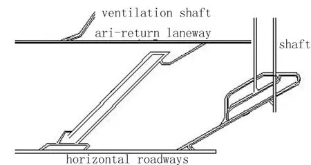
Fig. 2 Spatial structure of underground mining
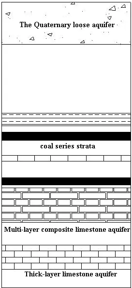
Fig. 3 Sketch geological profile map of North China coal mine area
1.3 Mine aquifer structures and hydrogeological characteristics
The main aquifers in Fengfeng mine area are thin layer limestone aquifer of Taiyuan Group and the hugely thick layer limestone aquifer of Ordovician or Cambrian on the bottom of coal seams (Fig. 3). When mines were abandoned,groundwater in the multiple limestone aquifers could be the main water source filling up underground spaces because of their higher water pressures. Due to disturbance and destruction of surrounding rocks caused by coal mining as well as groundwater rebound after the mine was abandoned, the seepage field and stress field in the abandoned mine area would be in a relatively unstable state for a long time (Fig. 4), and tended to adjust to re-equilibration after the mine was abandoned.In summary, the media types in abandoned mine are roughly divided into the following three categories:
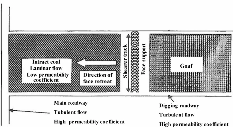
Fig. 4 Sketch map of tunnels and mining plate
(1) Tunnel pipe flow media: The media is a large pipe system mainly composed of the laneway system and distributed as a large network. The flow within the network is turbulent and cannot be described by common seepage theory. This paper employed the pipe flow hydromechanics and the principle of energy conservation to study and simulate pipe flow movement in such media.
(2) Caving zone and fissure zone media: Groundwater in those kinds of media accepts recharge from the pipe flow media and groundwater level rises fast. When groundwater level reaches the top of the caving zone, it gradually infiltrates into the overlying fissures, or leaks into other aquifers along faults. The lateral flow could be one of the main recharge sources making groundwater level rise in caving zone.
(3) Porous medium: The flow is laminar in the media. In some mine areas, the recharge sources could be infiltration from tunnels and faults, runoff from other aquifers and surface seepage (CHEN Chong-xi, 1995; HE Yang, 2007; WANG En-zhi,1992; WU Yan-qin and ZHANG Zhuo-yuan, 1997;XIONG Chong-shan and WANG Jia-chen, 2005).Although the porous medium could be the major storage space of groundwater, its permeability is generally lower than those of tunnel pipe flow media and caving zone and fissure zone media.Therefore, the groundwater level of this zone usually rises more slowly. As the flow speed is slow,groundwater recharge in porous media and groundwater level recovery may take quite a long time.
2 Establishment of theoretical models
2.1 Establishment of laneway system’s groundwater flow model
With the replenishment of groundwater inrush,groundwater level of laneway water-bearing media would rise rapidly, which will constantly lead to groundwater drainage to the wall rock. Therefore,the water-bearing media in the laneway system is not only the discharge area but also the recharge source area (ZHOU Zhi-fang, 2004) (Fig. 5).
As the water-collecting gallery, the laneway system has small resistance to groundwater flow.The flow in the laneway system is pipe flow which can be described in Bernoulli equation.
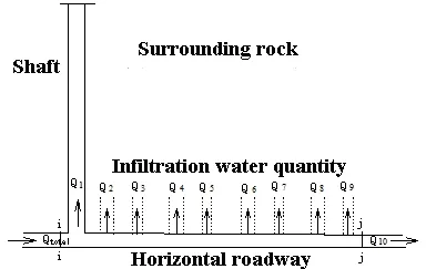
Fig. 5 Sketch map of laneway flow system in abandoned mine

where ziand zjare the geometric height at a certain point in any laneway sections i and j, and are defined as the potential head (L);are i and j sections’ pressure height, and are defined as the pressure head (L);are the mean kinetic energy of unit weight liquid in flow cross-section, and are defined as the velocity head(L); hijware the head loss (L) (CHEN Chong-xi et al. 2004).
The boundary of the laneway system is laneway walls, and the groundwater in laneway drains to wall rock through the laneway walls. The discharge varies with the difference of groundwater level at different sides of the laneway walls and the permeability coefficient of wall rock (LIU Zhong and ZHANG You-tian, 1996; WANG Yuan et al. 1996). Hence, the boundary of the laneway system is regarded as variable flow boundary, the discharge can be calculated by referring to the groundwater exchange formula of the “three zones” model described in the following text.
2.2 Mathematical model of groundwater flow at gushing points of abandoned mine
The groundwater inrush passages were conceptualized as pressurized pipes, assuming that they are circular and neglecting the variation of pipes’real shape and flow states. Groundwater flow was of free discharge in the initial stage, and it would turn to submerged discharge with the rise of groundwater level in the tunnel of abandoned mines. According to the principle of hydromechanics, the discharge can be calculated using the following equations.
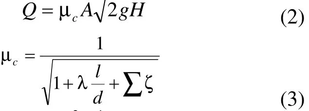
where Q is discharge (L3T-1); l is the length of pipe(L); A is the area of flow cross-section (L2); H is water head (L); λ is the frictional drag coefficient, which is dimensionless; cµ is flow coefficient of the pipe system, which is dimensionless;is the sum of local head loss coefficients.
3 Simulation of groundwater level recovery of abandoned mines in Fengfeng mine area
3.1 Establishment of "Three zones"model in abandoned mine
Because of coal mining, the groundwater system and the hydrogeological conditions have changed. According to the analysis of waterbearing medium in abandoned mines, the coal seam roof has formed three layers vertically, i.e.,caving zone, fissure zone and bending zone from bottom to top (YANG Tai-hua and YUAN Yong,1996) (Fig. 6). Therefore, the roof rock layer will be divided into three layers in the geologic modeling. It’s worth noting that caving zone and fissure zone both have great hydrogeological significance and are distinctly different in hydrodynamic characteristics (CHAI Jun-rui and WU Yan-qin, 2000; WANG En-zhi et al. 2002). It is of vital importance to determine and/or develop the suitable simulation method to simulate the groundwater flows in such complex water-bearing media. We employed FEFLOW program incorporating a newly developed add-on model (inrush(discharge) model) to simulate groundwater level recovery processes in the abandoned mines,considering the suitability and flexibility of computer programs for such kinds of cases.

Fig. 6 Sketch map of "three zones" model
The water heads in laneway were calculated by FEFLOW pipe flow plugin. The outer boundary was generalized as flow boundary. The main replenishment sources were three water inrush points in tunnel, neglecting the recharge of surface water and runoff between aquifers. The finite element mesh generation was conducted by FEFLOW. The water flow in laneway was regarded as pipe flow, and the Manning-Strickler formula was used for the calculation of flow velocity and head loss. When calculated by FEFLOW, the target water level was the regional groundwater level of the area, and the discharge would be zero while the balance approached. The key of newly developed inrush (discharge) model programs is listed in appendix.
3.2 The simulation of groundwater level recovery in abandoned mine
3.2.1 Characterization of hydrogeological conditions
As mentioned above, water-bearing media in abandoned mines are divided into laneway pipe flow media, caving zone and fissure zone media as well as porous media. The flow states are different in different medium, showing the coexistence of Darcy flow and non-Darcy flow as well as the complexity of water exchange. Owing to long-term continuous pumping during coal mining, the groundwater level declined greatly, resulting in groundwater depression cone in the mine area.When the pumping stopped after mines were abandoned, groundwater inrush flowing into abandoned mines continually became the main recharge source. Ordovician limestone groundwater from the bottom of coal seam is the main replenishment source as is mentioned above, and the groundwater flows into laneway through the inrushing points caused by previous mining exploitation.
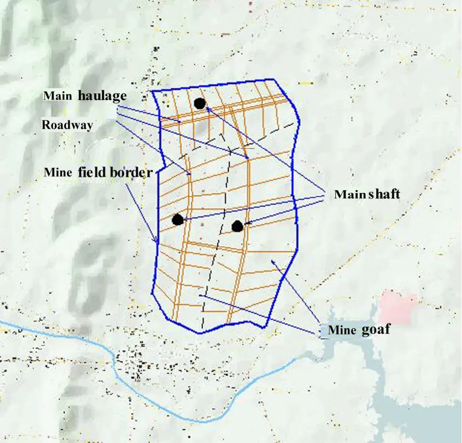
Fig. 7 Sketch map of abandoned laneway boundary
3.2.2 The hydrogeological structure model and parameters partition in abandoned mines
As stated above, different medium zones caused by coal mining have different hydraulic characteristics. The bending zone could be regarded as an aquitard. The tunnel can be defined as a variable water head boundary and FEFLOW was used to simulate the variation of groundwater head in tunnel system. It was supposed that underground mining system had a poor hydraulic connection with the near-surface unconsolidated aquifer and surface water, considering the depth of coal mining. Based on these conditions, the geological model was established in Fengfeng mine area. The area of abandoned mines is 12.2 km2approximately and the laneway system and ventilation system were subdivided so as to simulate it more accurately (Fig. 7 and Fig. 8).
The integration of No. 1 Mine, No. 2 Mine and Quantou Mine were performed in 1980s, and mining level is ±0, -180 and -400, respectively.The boundary of mining area consists of natural impermeable faults (Fig. 7). Combined with the“three zones” model, mining area can be vertically divided into 11 layers including 3 mining layers.Among the 11 layers, there are 3 caving and fissure layers, 3 bending zone layers and 2 aquifuge layers. The aquifer parameters were determined by taking into account the exploitation area and the disruption degree of wall rocks, and by referring to the estimated values of mining periods (Table 1). Parameters of tunnel, namely cross-section area and roughness coefficient, were defined on the basis of Manning-Chezy formula’s requirement and the actual situation of mines(Table 2).
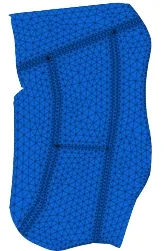
Fig. 8 The model of abandoned mine and the subdivided tunnel
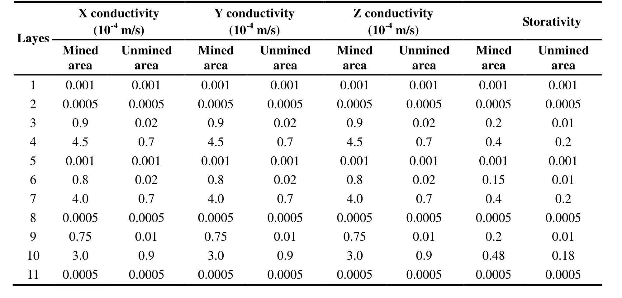
Table 1 Data for layer division and parameters
According to previous investigations, the study area has three sets of laneway systems, and three different mining levels. No.1 Mine and Quantou Mine were connected by ventilation tunnel. The model combining 3D geological model and laneway system was established as shown in Fig. 9.

Table 2 Hydrological parameter of tunnels
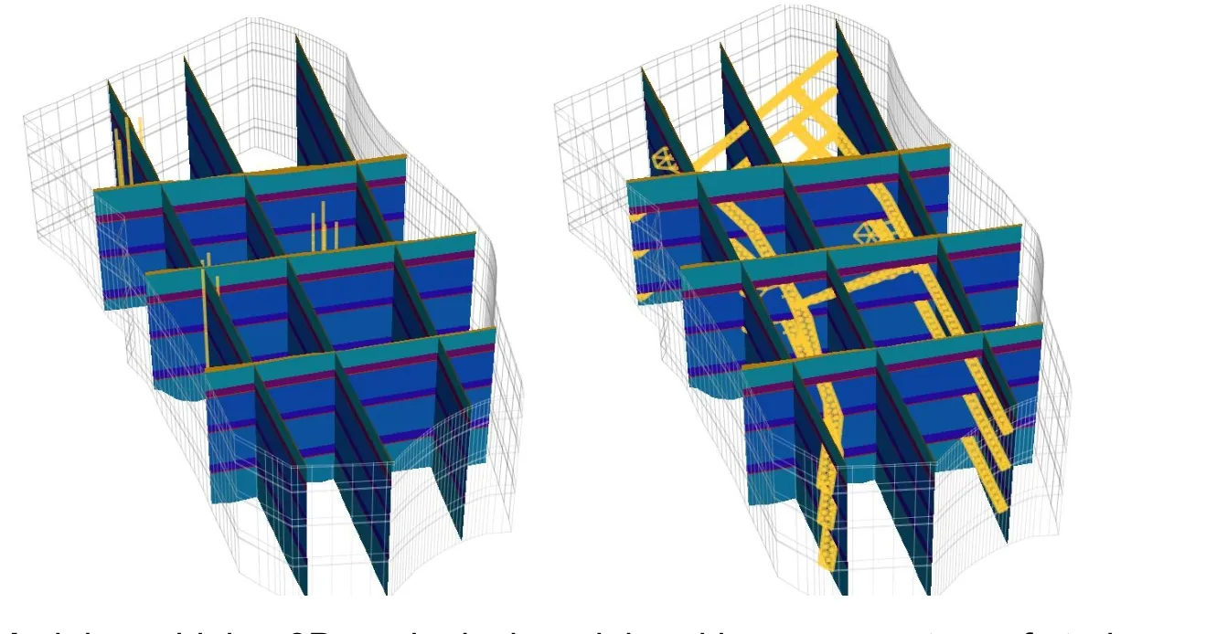
Fig. 9 Model combining 3D geological model and laneway system of study area
As the main water-storing media in the abandoned mine, the goaf plays a significant role in the process of groundwater level recovery.While tunnel generally controls the groundwater recovery, as every mining level was connected by vertical and horizontal tunnels.
4 The process of groundwater recovery in abandoned mines
The pipe flow plugin of FEFLOW program and the newly developed inrush (discharge) model can effectively simulate the process of groundwater recovery in abandoned mines. The curve of groundwater level recovery process was shown in Fig. 10.
As is shown in Fig. 10, groundwater level rises fast in the early stage, and slowly in later stage.There are many reasons for this phenomenon.Firstly, at the level of -400 m, the initial groundwater level was low and the difference of groundwater levels between the recharge source(gushing points) and the mine aquifer is large. The high hydraulic gradient made the groundwater inflow of the gushing points relatively larger.Secondly, both the mining space and chamber were relatively small in the deep mining level, which were filled up relatively fast, causing groundwater level rise faster at the level of -400. As the volumes of goaf and chamber vary with the elevation(mining level), and the smaller volumes are, the faster groundwater level will rise. At the level of±0, the volume of goaf was generally larger and could hold more water, so the groundwater level rises more slowly. When the overall groundwater level rises to the level of ±0, No. 1 Mine will be connected to Quantou Mine and No. 2 Mine through the ventilation tunnel, the groundwater level will rise synchronously at lower speed.
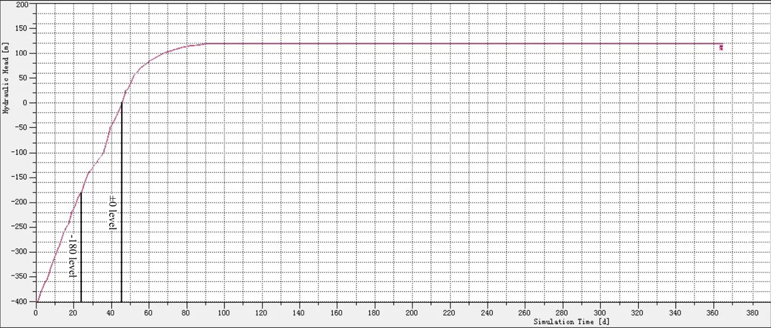
Fig. 10 The curve of groundwater level recovery process in abandoned mines
As the curve of groundwater level recovery process shows, the groundwater recovery slows down when the overall groundwater level rises to the level of -180. This phenomenon is related to the characters of the surrounding rock and the volume of goaf. When the groundwater fills up the whole goaf, groundwater exchanges between the goaf and space of the level of ±0 by the vertical tunnel. According to the results of simulation,water volume in the goaf below the level of ±0 m reached 6.6028×10⁶m3and the duration was around 40 days. When the groundwater level reached above the level of ±0, groundwater level recovery rate obviously slowed down, as the volumes of tunnels and goaf were relatively large.The duration of groundwater filling up the tunnels and goaf became longer, which accordingly made it longer for mine groundwater to reach the target level (regional groundwater level). The mine groundwater filling the area up to the level of ±0 required a time of 55 days and the amount of water was close to 8×10⁶m3. The mine groundwater level recovering to the regional groundwater level required 95 days and the volume of water filling up was around 1.41195×10⁷m3. The tunnels were filled with water up to about 2.136×10⁵m3. The simulation results are close to the actual data which suggests the desirable effect of the simulation.
5 Conclusions
The study integrated the pipe flow model,“three zones” model and groundwater inrush(discharge) model to simulate groundwater recovery process in the abandoned Fengfeng mines by using the FEFLOW program and a newly developed add-on sub-program. The results show that groundwater level rose faster in the early stage while slower in the later stage. The processes were controlled and influenced by factors such as groundwater level difference between inrushing points and mine aquifer, different elevations of laneways, different space of the goaf, and variation of groundwater flow pattern in different media.The groundwater in laneway pipe media is non-Darcy flow, while groundwater in fissures and porous media is Darcy flow at different velocities.Thus, there is coexistence of Darcy flow and non-Darcy flow in the complex systems. The gushing groundwater would firstly flow into laneway system. Due to the small resistance and fast groundwater flow, groundwater quickly bursts into laneway system and a small part of water flows into the fissures and pores of surrounding rock. Because of the larger hydraulic gradient at the initial state, the groundwater flow rates were larger and water level rose rapidly in the laneway system. The groundwater level rose slowly with the hydraulic gradient and flow rates decrease in later stages. Due to the groundwater level recovery in tunnels, groundwater tended to infiltrate into the surrounding rocks. The water levels in different water-bearing media kept changing, and the relations of groundwater recharge- discharge among different media repeatedly changed until the equilibrium was reached. In the whole process,water in tunnels is one of the main sources recharging the surrounding rocks.
The simulation shows that groundwater level recovering to regional groundwater level required 95 days and the volume of water filling up was 1.41195×10⁷m3. The amount of filled water in tunnels was around 2.136×10⁵m3. The simulation results are close to the actual data which suggests the desirable effect of the simulation. The study has demonstrated that it is important and effective to generalize and classify water-bearing media in the simulation. The study could enhance the understanding of mine structural characteristics and groundwater recovery processes in abandoned mines, and provide theoretical basis and technical support for the protection of geological environment and water resource management in mining areas.
Acknowledgements
We thank Mr. BAI Zhi-hui, Mr. YUE Wei-zhen and Mr. CHAI Zhen-jun from the Fengfeng Coal Mining Administration for their assistance in field work. This study was supported by the National Natural Science Foundation of China under grants No. 41272269.
杂志排行
地下水科学与工程(英文版)的其它文章
- Building a scientific and ecological earth-on an important field of geo-science: Geo-environment and construction engineering effect
- A discussion of up-flow springs
- Statistical characteristics of heavy metals content in groundwater and their interrelationships in a certain antimony mine area
- Thermal stresses analysis of casing string used in enhanced geothermal systems wells
- Groundwater resources in karst area in Southern China and sustainable utilization pattern
- Study on engineering-hydrogeological problems of hydroelectric project
