Building a scientific and ecological earth-on an important field of geo-science: Geo-environment and construction engineering effect
2016-11-25LUYaoruZHANGWeiLIUQiYANGMinZHANGFeng
LU Yao-ru , ZHANG Wei LIU Qi, YANG Min ZHANG Feng-e
1Institute of Hydrogeology and Environmental Geology (IHEG) of Chinese Academy of Geological Sciences (CAGS),Shijiazhuang 050061, China.
2Department of Geotechnical Engineering of Tongji University, Shanghai 200092, China.
Abstract: This paper explores the 12 aspects of geo-environment and construction engineering,including the earth evolution, the structure of geological bodies, the comprehensive utilization of resources, the geo-environmental effect, the engineering construction, the sustainable development and, etc. This paper presents that the good environment could only be created through the conservation and efficient utilization of resources, the joint efforts of disaster prevention and mitigation, as well as the avoidance of adverse environmental effect caused by human activities. This paper concludes that, to build a scientific and ecological earth, the development laws of geo-science must be learnt.
Keywords: Science; Ecology; Earth; Development; Effect
Geo-science is a subject that studies the formation and evolution of the earth internally and externally. Based on the exploration of minerals,stratum, paleotology, evolution of the sea and the land, crustal movement and other fundamental conditions, geo-science used to center on searching for various mineral resources of great significance to mankind, including metal, non-metal resources,coal, oil and gas, etc. The exploration of mineral resources in China dates back to thousands of years ago, with the tunnel system built for copper mining over 3 000 years ago in Daye, Hubei Province as a good example.
In modern times, another important area of geo-science emerged, namely hydrogeology,engineering and environmental geology. This area involves the exploration of mineral resources,engineering construction, urban development and various aspects of people’s daily life. That is to say,hydrogeology, engineering and environmental geology are deeply involved in human existence and development, including basic necessities of life, people’s living environment as well as the development of industry, agriculture and tourism,etc. (LU Yao-ru, 1973, 1986, 1999a, 1999b).Therefore, we must learn the development laws of geo-science so as to maintain a good living environment for mankind, and in other words, to build a scientific and ecological earth.
The following 12 aspects are also major research directions of this field.
1 Motion mechanism of geospheres and the evolution of the earth
As one of the planets in the solar system, the earth moves around the sun. The movement of the earth is under the influence of the solar system or even the impact imposed by the Galactic System on the solar system (XU Dao-yi et al. 1983).Currently, people focus more on supernova explosion. In 1933, Baade and Kaczynski from the U.S., put forward the concept of supernova explosion (the explored celestial body), which is over hundreds or thousands times brighter than the classical nova (exploring celestial body, one of the unstable stars). According to YANG Zheng-zong’s calculation, the total radiation energy of four historical supernovas (SN1006, SN1054, SN11572,SN1604①(①1006/1054/1572 is the date)) reaches as much as 1.23×1042-1.15×1043J. The mechanism of water formation and evolution exists both in the nebulous star studied by I·Kant or P.S.de Laplace and the expanded nebula generated from the supernova explosion.
The moon is the satellite of the earth, and the theories between its formation and the earth include:(1) Cognate bodies differentiation hypothesis; (2)heterologous bodies capture hypothesis; (3) cognate and heterologous bodies evolution hypothesis (LU Yao-ru, 1999b). Without getting into too much more detail because of the contraints of space, what needs to be stressed is that there is gravitational tide in the Earth-Moon System. Fig. 1 shows the tidal phenomena of groundwater influenced by the moon’s gravity in Yong’an, Fujian Province.

Fig. 1 Ground water range of the ZK14 hole influenced by the moon’s gravity in Yong’an, Fujian Province (according to the data observed by the Bureau of Geology and Mineral Exploration in Fujian Province)
According to Newton’s formula of Universal Gravitation, the moon’s gravity on the Earth per groundwater unit is:

in the formula: Mm-quality of the moon; ma-quality of unit water body; Dm-e-distance between the moon’s core to the earth’s core; re-semidiameter of the earth.
Similarly, the sun does have gravity on the earth. Though the sun is heavier than the moon, the sun’s gravity on the earth is smaller than that of the moon due to its greater distance (LU Yao-ru,1999a). Therefore, the calculation of the moon’s tides in ancient China is quite clear.
In the future, more research on the influence of cosmic factor on the movement of geospheres should be conducted (LU Yao-ru, 1999c).
The earth has four lspheres, namely, lithosphere, hydrosphere, atmosphere and biosphere.Their movements demonstrate in their interdependence and mutual influence. For instance, the lithosphere mainly contains rock and soil, with water and vapour in its cracks, but water and vapour could also be found in hydrosphere and atmosphere. There are human beings and other living creatures in the lithosphere. These four spheres have their own dynamics while influencing and constraining each other.
2 Changes of three-phase matter and three-phase flow
All matters, landscapes and creatures on the earth are, in fact, the combination of solid, liquid and gas. Since the three-phase matter is changeable,the phase transformation may occur. The main change of solid is its melting point, which is related to the pressure (Simon F, 1937).

A-constant related to internal pressure;
Tm-melting temperature at pressure P;
Tmo-melting temperature at atmospheric pressure;
C-constant
The main changes of liquid are its freezing and boiling temperature, being 0 ℃ and 100 ℃ respectively at a normal pressure, under which the solid-phase ice and gasification are generated. At a certain temperature, gas may turn into liquid. In nature, the three-phase matter is in a constant conversion (LU Yao-ru, 1986b, 2003).

Continuity formula for liquid is:υx, υyand υzrepresents flow rate component at x axis, y axis and z axis respectively. When density

For the compressible gas, that is:

φ-the velocity potential produced by the compressed air and the produced elastic wave velocity υac.

The buoyant force for floating gas among the three phase matter is ρB=ρgva.
This kind of phenomenon is very universal in nature. With various kinetic energies, the analysis of solid movement and sediment among threephase matter (in river) is shown in Fig. 2 (LU Yao-ru, 1986a, b).
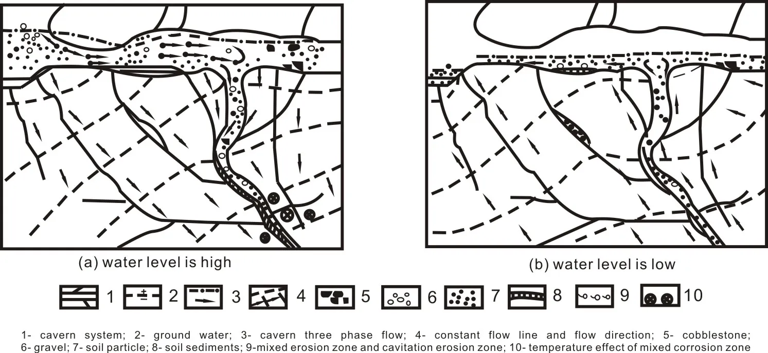
Fig. 2 Sketch map of solid gravel movement and sediment of three-phase matter in river
The higher the flow rate is, the greater the diameters of the moved particles in the upper reaches are. Hence, there are multiple manifestations of three-phase matter flow rate change in karst caves. The various evolutions of the threephase matter in the top of the cave is demonstrated in Fig. 3 (LU Yao-ru, 1986b; LU Yao-ru, 1990).
In 1920s, Gutengurg B held that there was a low-velocity layer of seismic wave 100-120 km underground. Later earthquake exploration found a material belt softer than upper and lower rock mass 60-250 km underground, and that is, asthenosphere.
The erosion in the asthenosphere requires relatively high temperature. Through another calculation of melting-point gradient in the earth core, Higgins G and Kcnmedy G G (1997) showed the linear relation between the melting temperature Tm at certain pressure and the volume change△V/V0△ under mutual pressure.
Referring to the related books enables us to get an initial concept of lithosphere hydrogeology(NIU Wen-wen, 1981; LIN Wu-de, 1981; LI Yan-dong et al. 2014). There are solid, liquid and gas in the asthenosphere, and they are in constant changes. The internal erosion and sedimentation in asthenosphere serve as an energy source for the changes of the earth crust, the sea and the mountains. Sketch map of the asthenosphere is shown in Fig. 4 (LU Yao-ru, 1999).
3 Features and geological structure of hydrodynamic conditions
The structures of geological bodies, including the strata characters, combination layers and the structural features, constitute the structural characteristics of various watery and water-free rock masses and watery systems. Combined with the water supply and the way of water movement and water discharge in them, the structures constitute the characteristics which determine their hydrodynamics (LU Yao-ru, 1962, 1973, 1999).
In nature, the actions of water and atmosphere are universal. No life can exist without water. It’s already known that water exists not only on the surface of the earth.
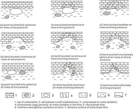
Fig. 3 Three-phase flow evolution of multiple migmatization on the top of the cave
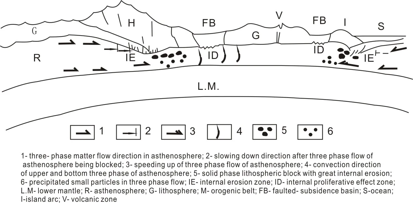
Fig. 4 Theoretical analysis chart of asthenosphere, the internal erosion and sedimentation
We believe that there are four layers in the earth: (1) The water-production belt in the earth core-earth mantle(A); (2) the water-gathering and three-phase flow belt in the asthenospherer (B); (3)the water-conservation and water-distribution belt in the deep crust and mantle(C); (4) the active circulation belt in the upper hydrosphere which can be divided into three parts: ① The sub-belt of the deep confined water seepage; ② the sub-belt of the phreatic water movement; ③ the sub-belt of airwater change.
Some people think that there is a huge water storage zone deep in the underground and some even observe that quite a few water bodies fall onto the earth from the outer space every day. All the above opinions need further research.
The complexity of karst water is embodied in the following five characteristics (LU Yao-ru,1973):
(1) The coexistence between the isolated and semi-isolated pipe flow and the ground hydraulic surface and diffusion flow with a unified water level;
(2) The interlaced and mosaic distribution of the watery rock mass and the water-free rock mass;
(3) The transformation of the unconfined water and confined water;
(4) The staggered appearance of the karst water turbulent flow movement and laminar flow movement;
(5) The complex change of the homogeneous aquifer and the heterogeneous aquifer.
The active circulation belt in the upper hydrosphere bears the closest relation to human living and development. There are water-bearing rock mass with pore water, water-bearing rock mass with crevice water, water-bearing rock mass with cave water in karst channels. Different waterbearing rock masses have different hydrodynamic characteristics, with the karst water-bearing rock mass being the most complex one.
4 Comprehensive exploitation & utilization of water resources and geoenvironment
Water is the source of life. At present, we are searching for the trace of water in another planet,which is also for the existence of other human beings.
In the primitive ages, people relied on the rainwater and the water in lakes and rivers for living. It is recorded that as early as in 453 BC,people started using water from the karst spring in the Jin Ancestral Temple. In 475 BC during the Warring States period, people started exploiting groundwater and BR Brine.
However, at present, different places have different focuses when it comes to exploiting water resources. Some mainly rely on the rain in the surface. The so-called Sponge City depends on collecting natural precipitation and impoundment.Some lean on reservoirs to increase water supply.However, in the arid areas, people have no choice but to exploit groundwater.
Water resources in China possess regional features. With different features, the drainage basins of different sizes and inland rivers are closely related to climate impact (LU Yao-ru et al.2002, 2003, 2004; LU Yao-ru et al. 2006). Special attention should be paid to eco-hydrology in the exploitation of water resources (LU Yao-ru et al.2006b).
Actually, six kinds of water in nature including rainwater, river water, lake water, ground water,artificial water and seawater, form a unified circulation system. It is of great significance to understand the circulation and conduct rational and comprehensive exploitation and utilization.
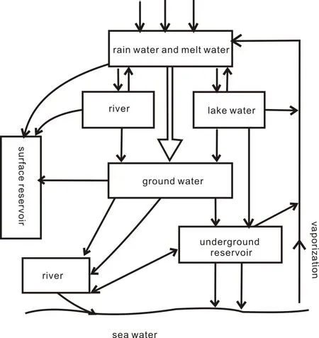
Fig. 5 Sketch map of hydrosphere
The comprehensive exploitation and utilization of water resources lies in:
(1) Utilization of various waters instead of a single kind to make the recoverable resources more abundant;
(2) Utilization and coordination of multiple water resources to guarantee better regulation and control;
(3) Conservation of water to achieve efficient utilization of water resources;
(4) Taking the the value of water into consideration in the process of utilization.
(5) Increasing water supply while consuming water to avoid water shortage;
(6) Regulation of water resources while using water. That is, supply- store- consume- supply...
Water is precious. It is not inexhaustible even though it is renewable.
In terms of the water system, underground reservoirs can be used to regulate water storage based on their characteristics, especially their hydrodynamic conditions and ways of water supply and discharge. For example, we can build underground reservoirs in sandy gravel layers or karst caves (LU Yao-ru, 1982, 1986, 1988; LU Yao-ru, 1987c, 1988).
Fig. 6 shows the underground reservoirs built in the karst regions.
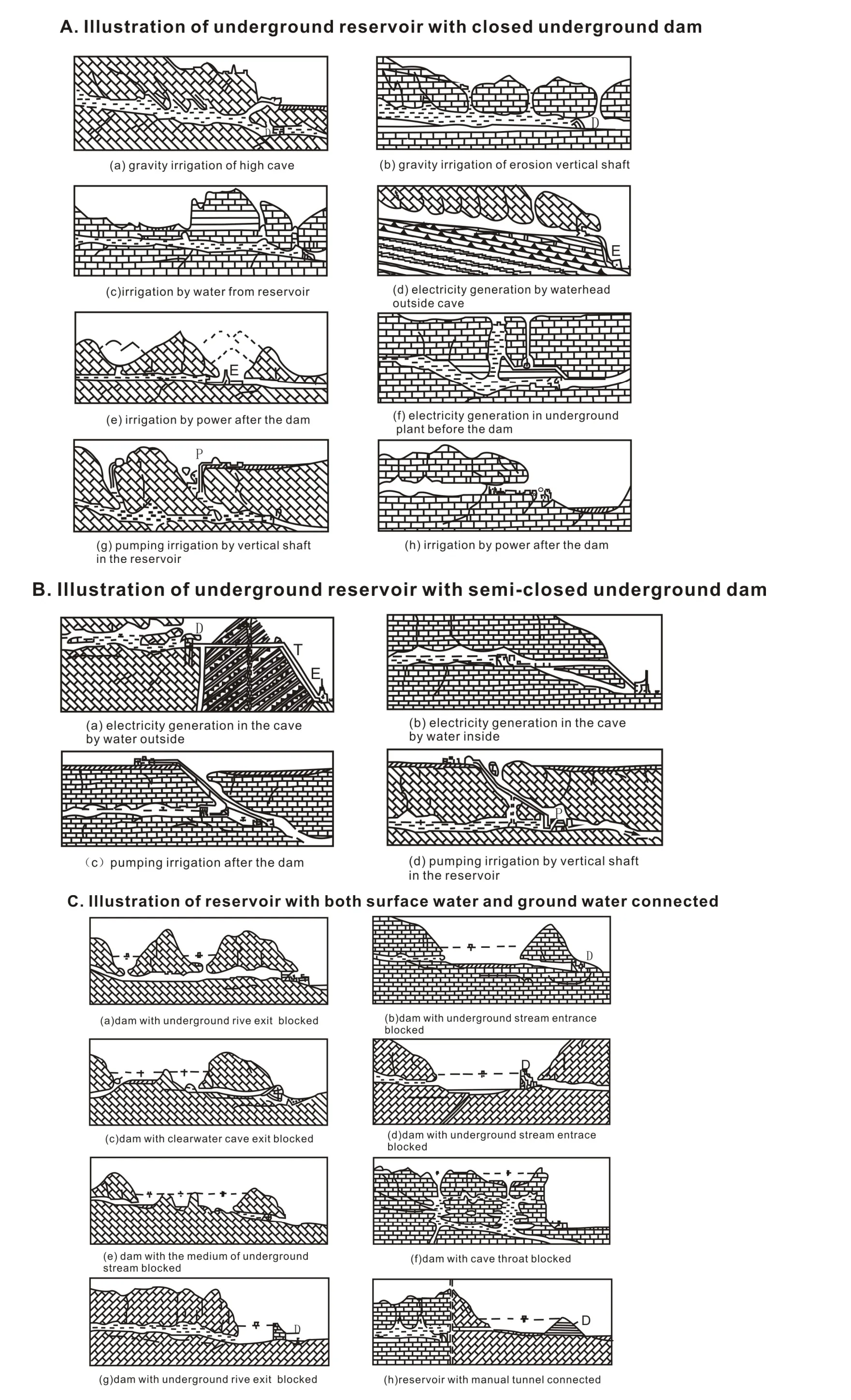
Fig. 6 Type map of underground reservoir in karst regions
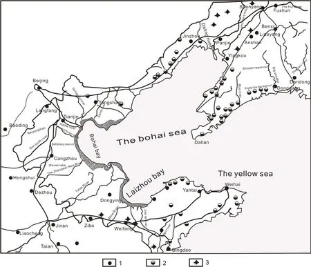
Fig. 7 Distribution map of underground reservoir in Bohai Rim area(SUN Xiao-ming et al. 2005)
5 Comprehensive prevention and control of geo-hazards and ecoenvironment
Many disasters have hindered the survival and development of mankind. Whether in the primitive society or today’s bustling world, despite a lot of damage caused by natural disasters, people have always managed to overcome them. The human population has greatly increased and people’s living standards have much improved, but disasters still exist, mainly including geological disasters(containing the earth’s surface), meteorological disasters and biological disasters (LU Yao-ru, 2000,2010).
Natural disasters have not put an end to human survival. However, great casualties will be caused if a place is continuously hit by serious disasters.Therefore, while being not intimidated by natural disasters, we should take disaster prevention and control seriously in tactics.
At present, the top priority is the comprehensive treatment of the six disasters, including flood, waterlog, drought, storm surge, geological disaster and water pollution.
The surface reservoirs built in the upper reaches of the arid and semi-arid regions usually deteriorate water in the middle and lower reaches.For instance, since the water in the upper reaches in the mountain areas of northwest China cannot flow downstream, people in the lower reaches have to get water from underground, which leads to the quick decline of the water level and deterioration of water environment. Another example is the Huangbizhuang Reservoir built in the main stream of the Hutuo River in Hebei Province. Originally,it only took 15 hours for water to flow from Huangbizhuang Reservoir to Zhongshan Hydrologic Station. As a result of the impoundment of Huangbizhuang reservoir, the lower reaches have to pump water from underground. In a flood discharge experiment, it took 190 hours for 878 000 000 m3water to flow to Zhongshan Hydrologic Station. But only 390 000 000 m3water reached the station, and the rest seeped into underground automatically.
The evolution of water environment in water storage and pumping of inland rivers is shown in Fig. 8.
A typical example is the Tarim River. The Taitema Lake, which dried up in the past, is full of water now by some proper measures of water adjustment (LU Yao-ru et al. 2003, 2004). The eco-environment of inland rivers and basins has also greatly changed.
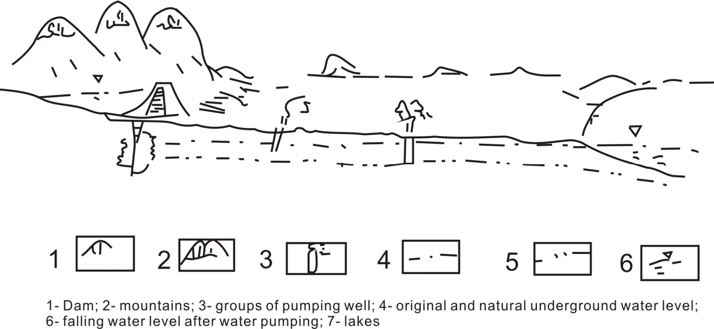
Fig. 8 Demonstration for dried-up inland river and basin after pumping
6 Development of urban clusters and its general effect on geo-environment
With the rapid development of towns, the urbanization rate of China reaches as high as over 52%. In the process of urbanization, the following principles should be obeyed:
(1) Scientific planning and comprehensive utilization of main resources, such as water, land, energy,mineral resources and biological resources;
(2) Comprehensive prevention, control and mitigation of natural disasters;
(3) Unified traffic network with different levels;(4) Rational and integrated planning and overdevelopment containing;
(5) Coordination of industrial development and joint innovation;
(6) Improvement of environment.
As for urban security, special attention should be paid to the prevention and control of disaster chain (LU Yao-ruet al. 2010; LU Yao-ru, 2010).
For example, through unified planning, the urban agglomeration in Beijing, Tianjin and Hebei has been integrated, covering an area of 139 200 km2. Because of long-time groundwater pumping, groundwater hoppers have formed as shown in Table 1 and Table 2. The surface settlements are demonstrated in Table 2 (ZHANG Zhao-jiet al. 2009).

Table 1 Groundwater depression cone in North China Plain

Table 2 The mining yield of ground water depression cone in North China Plain
According to the data above, future development lies in the integration of Beijing,Tianjin and Hebei as a whole by jointly carrying out resources exploitation, disaster prevention and control, and comprehensive planning of ecological industry.
The proper urban development embodies in the following:
(1) The number of people migrating to the large cities should be controlled. People moving from the large cities to the emerging cities should outnumber those who move from the emerging cities to the large cities;
(2) Industrial development in the large cities is restricted while the new industries and small cities are on the rise;
(3) An overall safe environment promotes the gradual harmony of urban and rural areas;
(4) Construction of small towns and their natural landscapes become important tourism resources;
(5) Small towns serve as a vital base for the cultivation of new-type talents.
7 Comprehensive development of mineral resources and geo-environment
Mineral exploitation, which goes hundreds of meters’ deep or even over one thousand meters,may result in water bursting, gas explosion, tunnel collapse, ground settlement, karst collapse, ground fractures, earthquakes and so on.
Fushun Coal Mine in the early days of the foundation of People’s Republic of China is taken as an example. The open pit with a depth of over 400 meters induced over 3 000-7 000 earthquakes in mining area every year, but usually low in magnitude, most of them being MS=I-III.
Due to the karst subsidence columns caused by both carbonate-type and sulfate-type karst, the water outburst of Fangezhuang Coal Mine in Tangshan even reached 10 m3/s at a time.
The karst subsidence columns which have posed much damage to the mining areas are demonstrated in Fig. 9 (LU Yao-ru and ZHANG Feng-e, 2006).
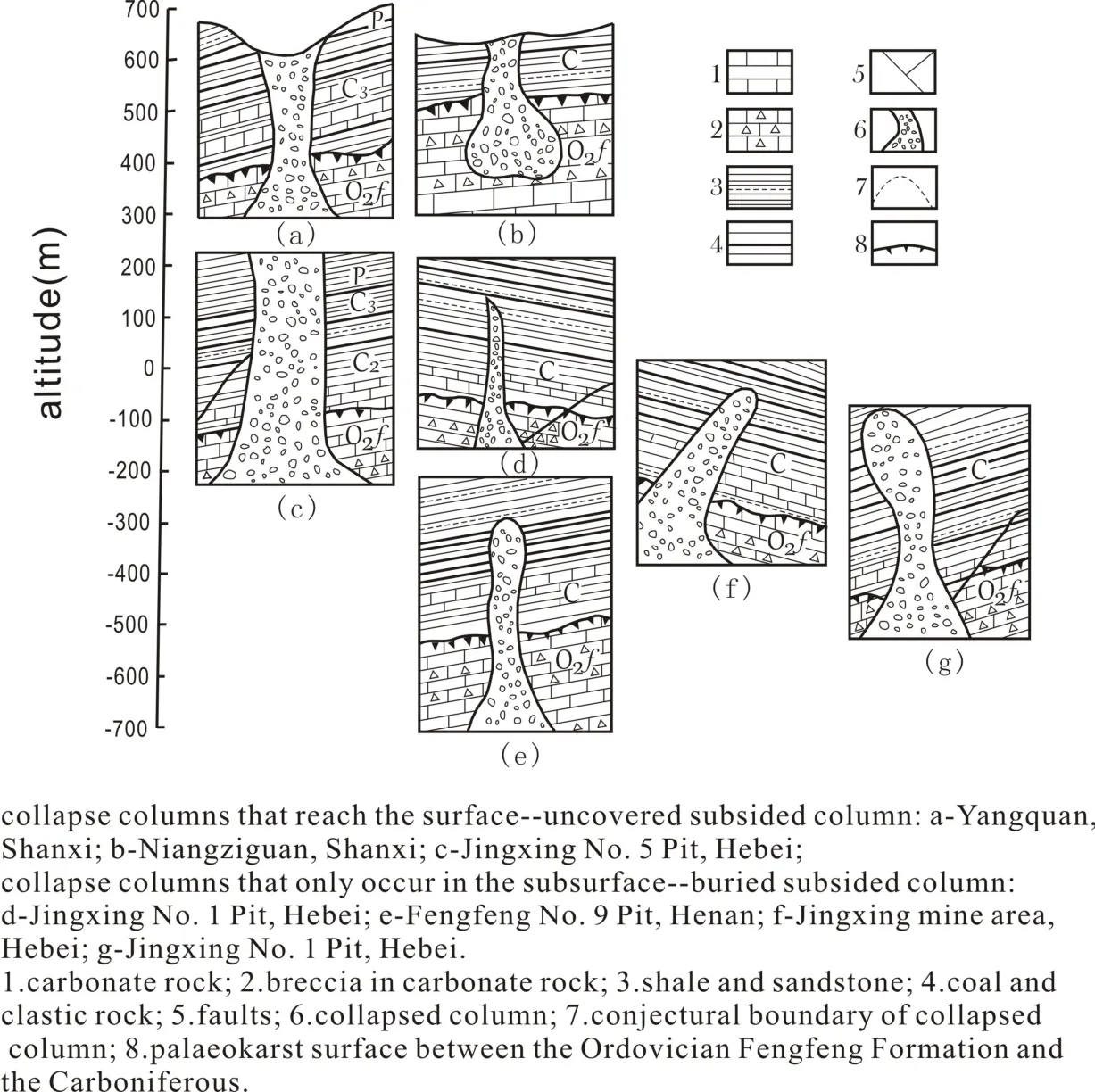
Fig. 9 Profile comparison chart of karst collapse columns in North China(LU Yao-ru and Cooper A H, 1996)
The water outburst in mining areas is not only related to groundwater but also to surface water.Hence, the prevention and control of the water outburst in mining areas requires a good understanding of local hydrological conditions and regional geo-environment. The measures are as follows: (1) Control and management of seeping rivers; (2) diversion of seeping rivers to other areas;(3) curtain grouting; (4) filling seeping channels;(5) drainage through tunnels; (6) pumping and discharge of wate; (7) ventilation by drilling; (8)isolation of groundwater-rich areas and so on.
As for the prevention and control of gas,exploration can be conducted before taking measures, such as strengthening monitoring and early-warning system as well as ventilation.
8 Exploitation of underground space and its geo-environmental effect
In large cities and megalopolis with a population of millions to 20 more million, it’s too crowded to only rely on the ground traffic network.Therefore, it’s necessary to develop underground traffic network (LU Yao-ru, 2001, 2010). In China today, over 30 cities have developed the transportation network of subways, with those in Beijing and Shanghai reaching hundreds of kilometers. However, due to different geological conditions, many problems have occurred during the construction and operation of subways, such as water outburst, mud outburst, subsidence(especially uneven settlement), sandy-mud outburst, piping, collapse and etc. Some of these problems even influence the surface buildings.Also, we must not pump groundwater in a large scale to develop underground transportation.Therefore, it’s indispensable to have a sound knowledge of geological conditions and to properly select routes and adopt construction schemes.
In the article “More emphasis should be attached to the geological and ecological environment effect in the exploitation of underground space” (such as subway construction), it puts forward the following suggestions: (1) Exploitation policies; (2) planning basis; (3) geological conditions; (4) comprehensive effect; (5) urban security; (6) scientific research; (7) prevention and treatment measures; (8) risk mechanism. We should seriously consider the geological conditions,possible negative effect and comprehensive environment effect, and establish risk analysis mechanisms so as to guarantee the safety of construction and operation.
The exploitation of underground space,including high speed rail (with the speed of 300-350 km/h) construction for cities with middle and long distance, requires relatively straight routes,small curves and more bridges and tunnels. For the high speed rails (300 km/h) which are four times faster than the electric trains along ballasted tracks,they focuses more on reducing the length of curved routes.
The depth of high-speed railway tunnels can reach hundreds and thousands of meters. Thus,some of the relevant geological problems, like water and mud outburst, active fault and collapse will be much more serious than those of urban subway. Moreover, other problems may also arise,such as the drying up of water in springs and reservoirs, land subsidence and karst collapse in the surrounding areas.
Because of the water and mud outburst, the 12.9 km-long and double tracking tunnel operated in 1990s endangered the traffic in it. By taking measures in the karst depression with a level difference of about 600 m, the traffic safety was restored as shown in Fig. 10.
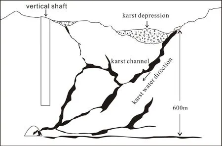
Fig. 10 Sketch map of karst water, mud and karst depression in 600 m deep tunnel
Since it’s hard to explore in the long tunnel, we stress the importance of “six steps in advance” on the excavated surface:
(1) Research of geological conditions in advance;
(2) Analysis of main geological effect in advance;
(3) Measures and equipment preparation in advance;
(4) Exploration of geological information in advance;
(5) Actions to deal with adverse effect in advance;
(6) Shelter built in advance.
It’s helpful to prejudge the yield and the way of water outburst based on the knowledge of the volume and pressure as well as the hydrodynamic conditions of the water-bearing caves. The details are shown in Fig. 11, Fig. 12 and Table 3.
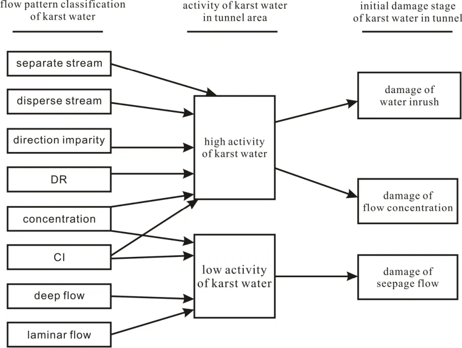
Fig. 11 Reference Diagram for the determination of initial damage of carbonatite karst water in tunnels
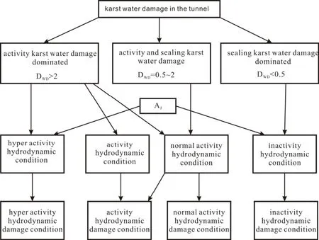
Fig. 12 Reference diagram for activity-damage classification of karst water hydrodynamic conditions
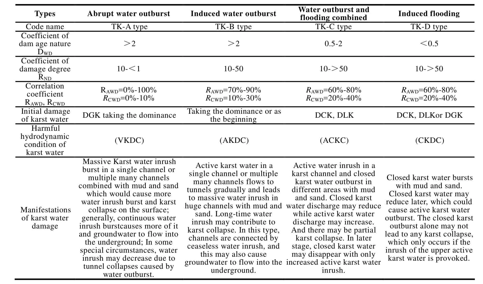
Table 3 References for karst water damage determination in tunnels
9 The large-scale engineering construction and its water environment effect
All large-scale engineering construction has an impact on geo-environment. The only difference is whether the positive effect or the negative one is dominant. In general, emphasis is made on the positive effect in construction, without due attention to the negative impact.
As it is mentioned by Dr. Sun Yat-Sen in his Nation-building Strategy American engineer John Lucian Sovage and some Chinese geologists came to the Three Gorges to select the site for the Three Gorges Dam before the foundation of the People’s Republic of China. When the Three Gorges project started in 1993, the main problems were: (1)Aggravated geo-hazards; (2) reservoir silting; (3)variation of water in the reservoir and environmental issues. At the same time, some suggestions were proposed (LU Yao-ru, 1999): (1) Enhancing investigation and prevention & control of disasters;(2) attaching more importance to ecological conservation, vegetation restoration and sediment retaining in the upper reaches to deal with the reservoir silting; (3) sub-control strategy to deal with pollution as shown in Fig. 13.
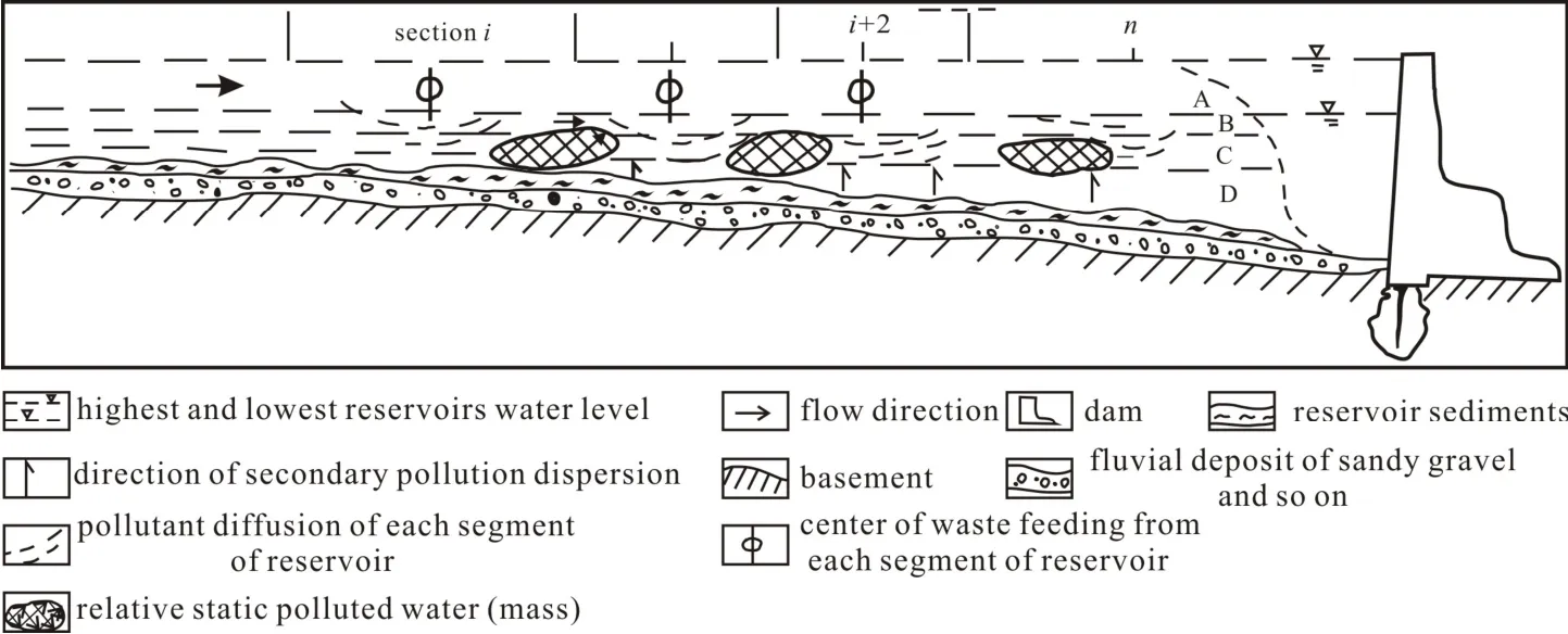
Fig. 13 Theory analysis chart of reservoir pollution
There are many pollution sources caused by waste discharge from different branches and direct discharge from cities and towns. Each source has polluted a certain reach. If there are n types of pollution sources, then there would be n polluted reaches. This can be explained by the following formulas:

There are multiple pollutant ions with pH, GH,Fe2+, Fe3+, phenol, cyanogen, Hg, Cr, As, NO3-,,,, F-, COD, BOD5and so on as the focus. For some important places, measurement of some items, such as heavy metal and organic matter can be added. With consideration of exceeding standard parameters instead of chemical reaction and secondary pollution caused by dispersion of pollutants, the pollutant ions between two sections during the period of I can be calculated as:

The total amount of pollutant ions of multiple pollution group during the period of T can be calculated as:

In this formula, IP T: quantity of solute (mg/L or g/m3) when accumulated pollutant ions form the polluted water mass during period T; QP T:quantity of solute (mg/L or g/m3) when multiple polluted water mass accumulated during period T.
As long as the sewage in the reservoir cannot be totally discharged to the lower reaches and the accumulated sewage cannot decrease or even by self-purification, the polluted water masses may develop. Through accumulation in many years, the polluted water masses will connect with each other to create a pollution zone. When there is much silting attached with massive pollutant ion, the secondary pollution sources would be generated.Theoretical analysis of reservoir pollution is demonstrated in Fig. 13.
The impact of reservoirs on geo-environment is concluded in Table 4.
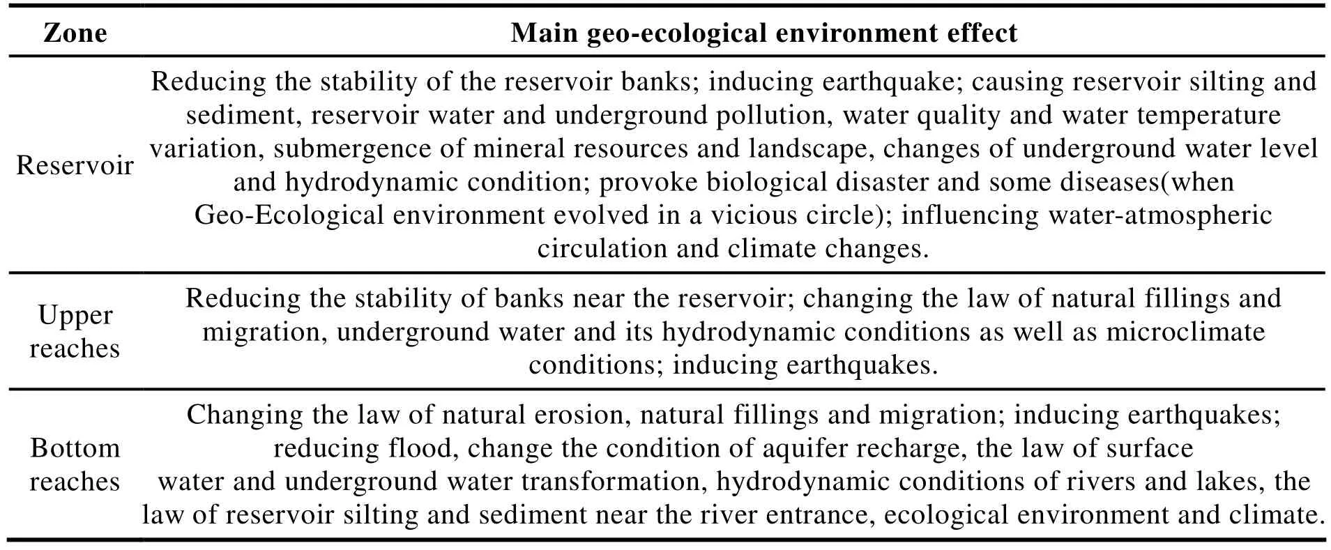
Table 4 Problems of geo-environment effect caused by the Three Gorges hydro project
The positive and negative effects coexist in every reservoir. A key point that needs more attention is the comprehensive effect on the geo-environment brought by the continuous large-scale water conservance and hydropower development, especially the earthquake effect.
The earthquakes induced by reservoir development can be divided into three types as shown in Fig. 14: (1) Broken by overload; (2)gasification burst; (3) cave collapse. Usually, the earthquakes are low in magnitude fromⅠ-Ⅲ. The magnitude of Xinbanjiang reservoir (now the Wanlu Lake ) in Guangdong was V.
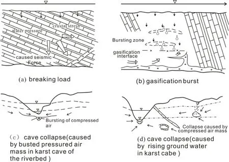
Fig. 14 Illustration of three kinds of earthquakes induced by reservoir
10 Ocean evolution and its geoenvironmental effect
The development of coastal zones and ocean is a vital direction for our future effort. The ancient Maritime Silk Route promoted the business, trade,cultural and religious exchanges among China,Southeast Asia, Africa and European. At present,China has already developed exploration ships that can dive as deep as over 7 000 meters under the sea.
First, the influence of sea water level on land-ocean interface should be given special attention. And the sea level even reached a hundred meters. Sea level changes are shown in Fig. 15.
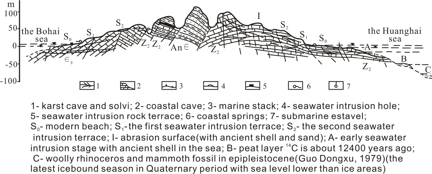
Fig. 15 Illustration of Hydrological environment changes in the Huanghai Sea-Dalian-the Bohai Sea
In Holocene medium-thermal period,Elaphurus clavidim migrated from the Huaihe River Basin to the north of North China Plain,while giant panda, Rhinoceros sumatranensis and Pavomutiaes which prefer to live in warm areas moved northward to Henan and Zhejiang at the latitude of 33°N. Elephas maximus could reach Hebei Plain at the latitude of 40°10’N and the most northern place that Rhinoceros sumatranensis reached was Banpo, Xi’an province. Freshwater animals in the Yangtze River Basin such as Leiocassis longirostris, Silurus meridionalis and Lampratala migrated northward about four latitudes where the temperature then was about 3 degrees higher than that of today.
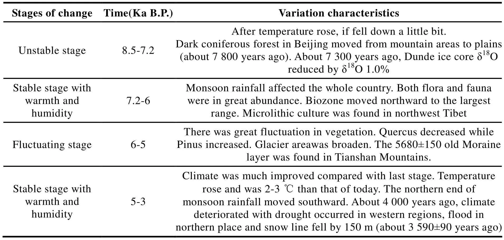
Table 5 The time of weather fluctuation of Holocene medium-thermal period
The melted glacier in the northwest made snow line higher and lake water rise. The coniferous forest in east Qinghai Province was distributed in places about 200-900 meters higher than those of today. Qinghai Lake was located at a point 25 meters higher than that of today. When Maxing xinghai Sea was about 5 540±65 years ago, the lake level was 5 meters higher and the temperature was 1-4 ℃ higher. There is no ice field any more in the Gonghe Basin in Qinghai. The dune was fixed and has developed into the black ancient soil.Tibet glacier was 400-700 meters higher. There was alpine shrub vegetation as honeysuckle and azalea in the first terrace of calcareous tufa in Boqu (about 5 000-6 000 years ago Boqu) with temperature about 3-5 ℃ higher. At that time,seawater could reach Lingyin Temple in West Lake, Hangzhou. After drilling, Elphidium crispum like Elphidium nakonokawense,Elphidiella kiangsuesis, Trochammina inflafa,were found in the marine sediments of that time.
Since Pleistocene, the sea level has gone through great changes with a rise of 12 cm in 30 years (GUO Dong-xu, 1979; LIN Guan-de, 1985).
Induced seawater intrusion by rising sea level and water pumping are demonstrated in Fig. 16.
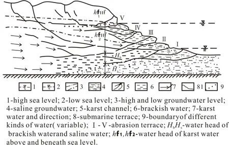
Fig. 16 Sketch map of seawater intrusion hydrodynamic system in Dalian
In the natural conditions, there is brackish water zone between fresh water and salt seawater due to water diffusion, movement and mixture apart from the normal hydrodynamic force.

In the equation:
Cn-underground water salt concentration (g/L) in natural world;
D-coefficient of diffusion (m2/s);
V-average permeability (m2/s);
Cp-changed salinity and concentration during water pumping (g/L);
C-salt concentration in admixing water during water pumping (g/L);
△- Laplacian.
Due to the pumping of underground fresh water in Dalian, saltwater intrusion has been exacerbated.
Calculated by Cl-ion and total mineralization,percentage of sea water and karst water in brackish water are:

In this formula, Vf·Vb, Vs- volume of karst water and Cl-ion content in salt water (mg/L)when there is Vbbrackish water. Accordingly, the brackish water in Dalian is comprised of 76.78%karst water and 23.22% seawater.
11 New energy development and geoenvironmental effect
Like many industrialized countries in the world,China uses dirty coal as its main energy supply.China’s current coal consumption accounts for 69% of the total amount, decreasing from 90%since the adoption of reform and opening-up in 1978.
At present, the new energy mainly refers to the renewable energy, including hydropower, wind power, solar power and tidal power. Though hydropower is clean and renewable, people’s opinions differ in the influence it has on river ecosystem (LU Yao-ru et al. 2011a, b).
The nuclear power will be further developed in China in the future. But the Chernobyl Nuclear Disaster in Ukraine and the recent Fukushima Nuclear Disaster in Japan caused concerns about nuclear power. It remains an important research issue to develop the third generation of nuclear power while fully considering its demand for geological conditions and its impact on environment protection. It involves issues as follows:
(1) How to guarantee stability and safety of nuclear power plant so as to avoid the influence exerted by geological disasters, such as surface faulting and landslide;
(2) How to deal with the nuclear waste;
(3) How to increase reserves in uranium mine;
(4) How to get material source from the outer space.
A great potential lies in the development of geothermal energy; the geothermal energy is utilized in human bathing and recuperation,heating and electricity supply. The common model of geothermal energy is the shallow resource shown in Fig. 17. If the deep resource compounds with the underground water with cycle channel,more geothermal spring can be provided.Nowadays, more efforts are made to develop the hot dry rock with more heat resources.
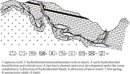
Fig. 17 Karst model with heat resources in geothermal energy
The major source for geothermal energy development comes from the underground hot dry rock. The research targets are:
(1) Searching for rock mass with high geothermal gradient and rich heat resource;
(2) Maintaining crust stability and avoiding great influence caused by surface faulting;
(3) Learning important indicators in geothermal energy development zones, namely thermal conductor, geothermal gradient and heat flow;
(4) Learning conditions of the cold water resources and water environment in surrounding areas;
(5) Understanding the prospect for the comprehensive development of various resources.
As for the geothermal energy, the research work should focus on the production condition of underground geothermal energy, the amount of heat resources and its development prospect, the relevant geothermal gradient, coefficient of heat flow and thermal conductivity.
China lags behind in the global ranking in terms of the amount of geothermal energy generation. We should catch up with other countries in the near future.
12 Ecological earth and sustainable development
As a complete planet, the earth enjoys a history of over four billion years. The earth is called a global village, as the development of science and technology makes communication and transportation much more convenient. Of course, the traffic in mountainous areas is still difficult and the exploration of the deep sea remains challenging The so-called global village mainly refers to cities and towns where people enjoy convenient communication and transportation. What’s more, the Internet makes it much easier for people from all over the world to exchange.
However, on the other hand, the increasing population and rapid development exert more negative influence on geo-environment and create more pollution. So the overall environment condition of the earth can never be neglected (LU Yao-ru, 1988, 1991, 1993, 1998).
It’s of great importance to maintain a favorable geological and ecological environment. All of us live in the same planet and it is our common obligation to protect it so as to promote the balance of biocapacity on earth. Since the middle 1970s,people have already lost the balance. Afterwards,the average consumption of human beings has always been exceeding the earth’s average biocapacity.
In order to improve the global environment and build an ecologic earth, we should pursue development and deal with our living environment in a scientific manner. Specifically, we should do things as follows:
(1) Maintaining a safe and peaceful environment;
(2) Reducing pollution source by using pollutionfree energy resources and making the coal usage harmless with new technology;
(3) Conserving energy and improving its efficiency;
(4) Establishing pre-warning system of global disaster prevention, control and mitigation;
(5) Promoting harmless and resourceful disposal of industrial and domestic wastes in the whole world;
(6) Formulating plans to protect eco- environment in a coordinated way;
(7) Promoting mutual help and common prosperity,with the developed countries supporting developing ones;
(8) Making joint efforts to protect our environment,creating new technology and innovations that can protect and improve the global ecologic conditions;
(9) Improving people’s awareness about the importance of environmental protection;
(10) Establishing global institutions to conduct publicity and supervision work.
It calls for concerted efforts to protect the earth that we share and rely on to live. To deal with this universal problem, research on hydro-geology,engineering geology and environmental geology,which are closely related to human development,should be advanced worldwide. The exchanges among professionals in this regard and their cooperation with relative engineering construction organizations should be enhanced.
The earth is shared by all mankind, and an ecological earth must pursue a scientific development.
杂志排行
地下水科学与工程(英文版)的其它文章
- A discussion of up-flow springs
- Statistical characteristics of heavy metals content in groundwater and their interrelationships in a certain antimony mine area
- Thermal stresses analysis of casing string used in enhanced geothermal systems wells
- Groundwater resources in karst area in Southern China and sustainable utilization pattern
- Study on engineering-hydrogeological problems of hydroelectric project
- Interactions between benzotriazole and corncob biochars pyrolyzed at different temperature
