Dynam ic and Thermodynam ic Featuresof Low and Midd le Clouds Derived from Atmospheric Radiation Measurement Program Mobile Facility Radiosonde Data at Shouxian,China
2016-08-12JinqiangZHANGHongbinCHENXiangaoXIAandWeiChyungWANG
Jinqiang ZHANG,Hongbin CHEN∗,Xiang’ao XIA,andWei-ChyungWANG
1Key Laboratory ofMiddle Atmosphere and Global EnvironmentObservation,Institute ofAtmospheric Physics, Chinese Academy ofSciences,Beijing 100029
2Collaborative Innovation Centeron Forecastand Evaluation ofMeteorologicalDisasters,Nanjing University of Information Science&Technology,Nanjing 210044
3Atmospheric Sciences Research Center,University atAlbany,State University ofNew York,USA
Dynam ic and Thermodynam ic Featuresof Low and Midd le Clouds Derived from Atmospheric Radiation Measurement Program Mobile Facility Radiosonde Data at Shouxian,China
Jinqiang ZHANG1,2,Hongbin CHEN∗1,2,Xiang’ao XIA1,2,andWei-ChyungWANG3
1Key Laboratory ofMiddle Atmosphere and Global EnvironmentObservation,Institute ofAtmospheric Physics, Chinese Academy ofSciences,Beijing 100029
2Collaborative Innovation Centeron Forecastand Evaluation ofMeteorologicalDisasters,Nanjing University of Information Science&Technology,Nanjing 210044
3Atmospheric Sciences Research Center,University atAlbany,State University ofNew York,USA
By using the radiosondemeasurements collected at Shouxian,China,we examined the dynamics and thermodynamics of single-and two-layer clouds formed at low andm iddle levels.Theanalyses indicated that the horizontalw ind speed above the cloud layerswas higher than thosew ithin and below cloud layers.Themaximum balloon ascentspeed(5.3m s−1)was located in thevicinity of the layerw ith themaximum cloud occurrence frequency(24.4%),indicating an upwardmotion(0.1–0.16m s−1).Theaverage thickness,magnitudeand gradientof the temperature inversion layerabovesingle-layercloudswere 117±94m,1.3±1.3°Cand 1.4±1.5°C(100m)−1,respectively.Theaverage temperature inversionmagnitudewas thesame (1.3°C)for single-low and single-m iddle clouds;however,a larger gradient[1.7±1.8°C(100m)−1]and smaller thickness (94±67m)were detected above single-low clouds relative to those above single-m iddle clouds[0.9±0.7°C(100m)−1and 157±120m].For the two-layer cloud,the temperature inversion parameterswere 106±59m,1.0±0.9°C and 1.0±1.0°C (100m)−1above the upper-layer cloud and 82±60m,0.6±0.9°C and 0.7±0.6°C(100m)−1above the low-layer cloud. Absolute differencesbetween the cloud-baseheight(cloud-top height)and the lifting condensation level(equilibrium level) were less than 0.5 km for66.4%(36.8%)of the casesanalyzed in summer.
radiosonde,cloud,dynam ics,thermodynam ics
1. Introduction
Clouds affect the radiation budget of the Earth’s atmospheremainly through reflecting the incoming solar radiation,absorbing the upwelling infrared radiation,and then re-em itting it at local temperatures(Trenberth et al.,2009). Therefore,the radiative heating/cooling caused by cloud vertical distribution of single-ormulti-layered clouds couple strongly w ith atmospheric dynamics,thermodynam ics and the hydrological cycle(Del Genio et al.,2005;Kalesse and Kollias,2013;Kunnen et al.,2013).Despite their significance,representationof cloudsinglobalclimatemodelsis far from realistic due to inadequateunderstandingof theunderlying dynam ic and physical processes(Stephens,2005;Tao et al.,2012)and considerablevariationsin cloud amountin both the verticaland horizontal directions(Zhang etal.,2005;Xi etal.,2010).The cloud feedback effectsassociated w ith climate changes have also been recognized as introducing the largestuncertainty in usingmodels to project future climate changes(IPCC,2007,2013).
Sherwood etal.(2014)highlighted the importanceof low cloudsand the associated feedbacks in affecting climate sensitivity.Compared to low and high clouds,less attention is paid to mid-level clouds because they do not produce significant amounts of rain or snow(Sassen and Wang,2012). However,m id-levelcloudsimpactboth theenergy budgetand verticalprofi le of heating in the atmosphere.In addition,the effectsof radiativeand latentheating ofmid-level cloudsare highly uncertain due to a lack of information aboutboth their frequency and phase(Riihimakietal.,2012).
Extensivesurfacestations,such as thosedeveloped by the Atmospheric Radiation Measurement(ARM)program(e.g., Lietal.,2005;Maceand Benson,2008)and Cloudnetin Eu-rope(e.g.,Haeffelin et al.,2005;Illingworth et al.,2007), which arewell equipped w ith ground-based remote sensing instruments,can provide information on the cloud properties over the sites(Zhao et al.,2011,2012).In addition to ground-based instruments,balloon-mounted radiosondes can penetrate cloud layers and thus provide in situ measurements of clouds,which,togetherw ith observational temperature,hum idity and pressure profi les,can be used to study atmospheric thermodynam ic and dynam ic processes(Manzato,2007;Kolliasetal.,2009).Radiosonde dataw ith high accuracy and vertical resolution have also been w idely deployed to determ ine the locations and boundaries of cloud layers(e.g.,Poore et al.,1995).Wang and Rossow(1995) used relative hum idity(RH)profi les to obtain the cloud vertical structure.Chernykh and Eskridge(1996)developed a cloud detection method based on the second-order derivatives of temperature and RH w ith respect to height.Cloud boundariesaredefined ifat leastoneof the two second-order derivatives iszero.Using radiosondedata,many studieshave analyzed cloud verticalstructure(e.g.,Chernykh etal.,2000; Wangetal.,2000;Minnisetal.,2005),but few havebeen validated due to a lack of trustworthy and/or independentproducts(e.g.,Wang etal.,1999;Naud etal.,2003).
As partof amajor U.S.–China joint field experiment,the East Asian Study of Tropospheric Aerosols and their Impacton Regional Climate(Fan etal.,2010;Lietal.,2011), an ARMmobile facility(AMF)was deployed at Shouxian, China in 2008.Using amodified version of themethod described by Wang and Rossow(1995),the radiosonde data obtained from the AMF campaign were used to derive the vertical cloud distributions(Zhang et al.,2010).Zhang et al.(2013)further carried out an extensive validation of the cloud retrievalmethod againsta ground-based remote sensingmethod atmultipleARMsites located in differentclimate regimes.Itwas found that the cloud layers derived from the twomethodsagreed wellat the Southern GreatPlains(SGP) site located in the m idlatitudes;however,the radiosonde tended to detectmore cloud layers in the upper troposphere at the tropicalwestern Pacific and north slopeof A laska sites.
Asmentioned,many previous studies have focused on the detection of cloud appearance from radiosondemeasurements.However,radiosonde data w ith high vertical resolution also provide a good opportunity to study the dynamics and thermodynamics of clouds,butvery few attempts of this typehavebeenmade.The dynamic and thermodynamic parameters of clouds can be derived from in situ measurementsby the radiosondeof temperature,RH andw ind vector w ith high vertical resolution,and its balloon’s speed of ascent.More importantly,analysis of the dynam ics and thermodynam ics of clouds can be performed based on the cloud detection result;therefore,we can explore the potential differences in theseparametersw ithin,below and above clouds. Thiswas the aim of the present reported study.This objectivewas achieved by analysis of the dynam ic and thermodynam ic characteristicsw ithin,below and above low andm iddleclouds,whichwerederived from the radiosondedataduring theAMF-Chinacampaign.A schematic representation of the analysis procedures is shown in Fig.1.To achieve this objective,dynam ic features,temperature distributions and their inversion structures,convective available potential energy(CAPE),the lifting condensation level(LCL),and equilibrium level(EL)were calculated from the radiosondemeasurements.A lthough CAPE isnota truemeasureof instability,it is stillw idely deployed as a predictor of atmospheric instability(Sobel et al.,2004).The LCL is a critical point for convection activities because saturation is required to realize the instability;therefore,it isoften used to estimate the cloud-base height(Craven et al.,2002).The EL is generally taken asan importantparameter for forecasting the convection cloud-top height in short-term forecasts.The resultsshould be beneficial for furtherunderstanding of the dynamicsand thermodynamicsof cloudsand theirneighboring environment.Potential difference in dynam ics and thermodynam ics between the cloud layers and clear regions can also help to interpretclimatemodelsimulations.
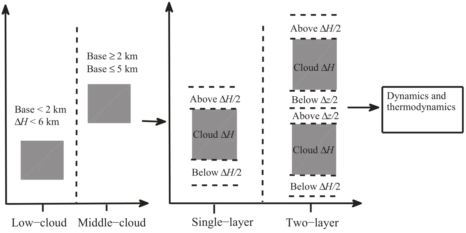
Fig.1.Schematic representation of the dynam ic and thermodynam ic study procedures below,w ithin and above clouds.ΔH denotes the thickness of cloud layers shown by the gray rectangular areas,and Δz is the distancebetween two-layer clouds.
Thepaper isorganized as follows:Section2 describes the data and algorithms.A detailed investigation of the dynam ic and thermodynam ic characteristicsw ithin,below and above cloudsover the AMF-China site is presented in section 3.A discussion and conclusionsare provided in section 4.
2. Data andmethodology
2.1. Data description
The AMF-China site at Shouxian,Anhui Province [(32.56°N,116.78°E);21m above sea level]was in operation from 14 May to 28 December 2008.The observation period can be divided into two parts:(1)the May-to-August Mei-yu season,which is characterized by high hum idity and frequent precipitation events associated w ith the East Asian monsoon system;and(2)the September-to-December dry season.During the campaign period,Vaisala RS92-SGP radiosondes were launched four times a day at 0130,0730, 1330 and 1930 LST.Profi les of temperature,RH,pressure, w ind speed andw ind direction atheights from the surface to generally higher than 10 km weremeasured.
In addition to the radiosonde measurements,groundbased active remote sensing instruments,such as a Vaisala ceilometer and a Micropulse Lidar(MPL)were also employed to detect clouds during the entire campaign period of AMF-China.Furthermore,a 95 GHz W-band ARMcloud radar(WACR)that can detectmultiple cloud layerswas installed from 15October to15December2008.By combining observations from the cloud radar,theMPL and the ceilometer,the Active Remote Sensing of Cloud(ARSCL)valueadded product(VAP)was generated by the ARMscientists to provide cloud boundariesw ith the bestpossible accuracy (Clothiaux et al.,2000;Kollias et al.,2009).The ARSCL VAPhasa temporal resolution of five seconds and a vertical resolution of 45m.Up to 10 cloud-layer boundaries can be identified in the ARSCL VAPproduct.Table1 illustrates the various datasets and their applications in locating the cloud layers.In this study,wemainly used the radiosonde data to derive the cloud layers and then investigated the dynamics and thermodynamics associated w ith the cloud layers.The ARSCL datawere employed to aid the radiosondemeasurements to locate the cloud layers if they were available.
2.2. Method
2.2.1. Cloud detection and classification using radiosonde data
We used the radiosonde-based cloud retrieval algorithm of Zhang etal.(2013),which wasmodified from Wang and Rossow(1995),to detect cloud boundaries.The algorithm employed threeheight-resolving RH thresholds to determine cloud layers,i.e.,them inimum andmaximum RH thresholds in cloud layers,aswellas them inimum RH threshold w ithin the distance of two neighboring cloud layers.A detailed descriptionof thealgorithm canbe found in Zhang etal.(2013).
Low cloudswere defined by theirbasesbeing lower than 2 km and their thicknesses less than 6 km.Cloudsw ith their bases ranging from 2 to 5 km were defined to be m iddle clouds.Only single-and two-layered low andmiddle clouds are discussed in this paper.The cloud-free layersabove and below cloudswere defined as follows:For the single-layer cloud,the cloud-free layer above the cloud layerwas determ ined as the layer ranging from thecloud top upwards to half of the cloud thickness(ΔH)level(Fig.1).Below the cloud layer it was defined in a sim ilar way but ranging from the cloud base downwards to theΔH/2 level.If the distance between the cloud base level to thesurfacewas less thanΔH/2, itwasdeterm ined tobe from thecloud basedownwards to the surface.For casesw ith two-layer clouds,the cloud-free layer below the higher cloud layerwas set to be the upper half of the cloud-free layersbetween the two-layer clouds(Δz).The cloud-free layerabove the lower cloud layerwas determ ined to be the lower half of the cloud-free layer between the twolayerclouds.Thedeterm ination of the cloud-free layerabove the higher cloud layer and below the lower cloud layerwas thesameas that for the single-layer cloud.
2.2.2. Dynamic and thermodynamic characteristics
Dynam ic features of the atmosphere were derived from the horizontalw ind speed and the balloon speed of ascent. The temperature structures,including the temperature inversion layersassociatedw ith the cloud layerswerealso investigated.In addition,three convective parameters(CAPE,LCL and EL)are discussed in this paper.
CAPE is a vertically integrated index and measures the cumulativebuoyantenergy in the free convective layer(FCL) ranging from the level of free convection(LFC)to the EL. The LFC is the levelatwhich the parcel temperatureexceeds the ambient temperature and parcels are unstable relative to theirenvironment.The EL is the levelatwhich the ambient temperature exceeds the parcel temperature and parcels are stable relative to their environment.The formaldefinition ofCAPE,adopted from Doswell IIIand Rasmussen(1994),is expressed as

Table 1.Information on the datasetsused in this study and theirapplications.

where Tvpis the virtual temperature of the parcel(units:K); Tveis the virtual temperature of the environment(units:K); ZELis the EL height(units:m),which is generally obtained from a T-ln p diagram;ZLFCis the LFC height(units:m);(units:K)is themean potential temperature in the FCL;and g is thegravitationalacceleration(units:N kg−1).
The w idely used Espy’s equation(Espy,1841),for the relationship between the LCL and dew-point temperature,is deployed to compute the LCL and isgiven by

where ZLCLis the LCL height(units:m),T is the temperature (units:°C),and Tdis the dew-point temperature(units:°C).
There are likely several temperature inversion layers that are separated above the cloud top.To ensure that the temperature inversion is related to the cloud as far as possible, only the fi rst temperature inversion layer above the cloud top is discussed in this paper.Themethod used to obtain the temperature inversion layer is the fi rst-order derivative of the temperature profi le w ith respect to height.The contiguous levelsw ith the fi rst-order derivative larger than zero are treated as the temperature inversion layer.Taking into account the complex structures of radiosonde-based temperature profi les,theremay be very thin layers not determined as temperature inversion layers located between two temperature inversion layers separated by a very short distance.To obtain reliable results,two neighboring temperature inversion layers are considered as one layer if the distance between these two layers is less than 50 m.The Vaisala RS92 radiosondemeasures data every 2 s,w ith an average speed of ascentof about5m s−1,resulting in a vertical resolution of about10m(5m s−1×2 s).The thicknessof the temperature inversion layer needs to be larger than 15m by considering that the temperature inversion layershould be larger than the vertical resolution of the radiosonde.In order to derive the temperature inversion layer that is close to the cloud top and thereby related to the cloud processes,the distance between thebaseof the temperature inversion layerand the cloud-top height should be properly considered.The occurrence frequency of the temperature inversion above the single-layer top heightwas66%,68%,71%and 71%if the distancewas set to be 50m,100m,200m and 300m,respectively.Although the occurrence frequency varied little,the thickness of the temperature inversion layer changed to some extent. Based on visual inspection,we found that reliable results were obtained by setting the distance as 200m,and so this distancewasused in the study.
3. Results
3.1. Cloud verticaldistributionsover the Shouxian site
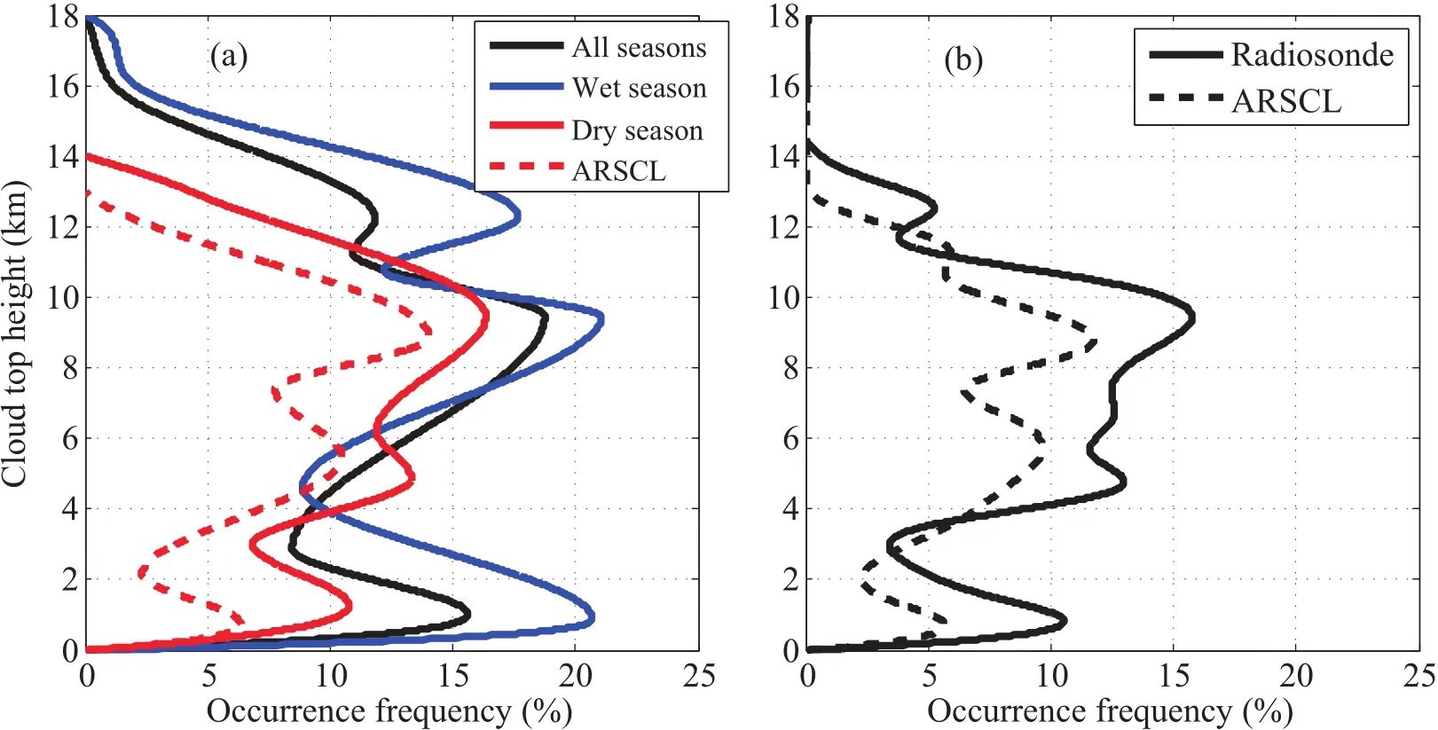
Fig.2.(a)Frequency distributions of cloud-top heights derived from the radiosonde observations during the entire AMF-China period(black solid line),in wetseason(blue solid line),in dry season(red solid line);and frequency distributionsobtained from the ARSCL data(red dashed line).(b)As in(a)but for cloud-top heights obtained from thesubsetof the radiosondeand ARSCL datasetgenerated attheirsimultaneously observed time.
Figure 2a shows the cloud-top height frequencies(CTFs) for all cloud samples derived from the radiosonde during the whole campaign period,in the wet season and the dry season,aswellas theCTFsderived from ARSCL data in thedry season.Therewere three peaks of CTFs for the radiosonde retrievals during thewhole period,which were located at 1, 9.5 and 12.5 km,respectively.The cloud-top heights in the wet season were generally higher than those in the dry season.The pattern of CTFswas sim ilar between the ARSCL data and the radiosonde data collected during the dry sea-son.However,themagnitude of cloud frequencies detected by ARSCL was significantly lower than those detected by radiosonde,which was likely due to the follow ing three factors:(1)the difference of the objects detected by two instruments caused by the balloon’s drift and fixed ground-based observation(Zhang etal.,2013);(2)the incompleteoverlapping observationalperiod associatedw ith thediurnalcycleof the cloud occurrence(e.g.,Zhang and K lein,2010);and(3) the differentobservation temporal intervalsbetween the two cloud products(Zhang etal.,2014).Figure 2b presents the CTF distributionsobtained from the radiosonde and ARSCL at concurrentobservation time,in which a large decrease of the differences in the CTFs between the two cloud products is revealed,ascomparedw ith Fig.2a.Ithasbeen proven that thecalculated cloud occurrence frequencyw illincreaseas the sample temporalintervalsincrease(Xietal.,2010).Thesample temporal intervalof ARSCL dataused in thisstudywas5 s.However,a radiosondegenerally spends~90min in theatmosphere to collectdata during one launch,whichw ill result in highercloud occurrence frequency calculated than the ARSCLmeasurements.Differences in the CTFsat the low and high atmospheric column levelswere larger than those in the m iddle troposphere.The radiosonde cloud retrievals tended to be larger than the ARSCL detections at the layer above 4 km,w ith amaximum difference of~7%.Besides the three reasonsmentioned above,the deficiency ofhigh-level clouds in the ARSCL cloud productswas also likely caused by the attenuation effect of thick lower-level clouds and/or fog in the cloud detection of the ground-based remote sensing instruments(Protatetal.,2014).
The number(percentage)of occurrences for the radiosonde detecting at least one cloud layer and non-cloud layer was 652(80.2%)and 161(19.8%),respectively.By using 10 yearsof data collected over the ARMSGPsite,we found that the radiosonde-based cloud occurrence frequency was 65%(Zhang etal.,2014).The radiosonde-based cloud occurrenceat the AMF-Chinasitewasabout15%larger than that at Taihu Lake(65%),which was about 500 km away from AMF-China(Zhao et al.,2014).The frequency of radiosondemeasurementsdeterm ining single-and two-layered low-andmiddle-cloud is presented in Table 2.The number (frequency)for the radiosondedetecting one-layer cloudwas 92(11.3%),ofwhich 51 and 41 were single-low and singlem iddle clouds,respectively.Therewere 39(4.8%)two-layer clouds,ofwhich 4 and 8 were two-layer-low and two-layermiddle clouds,respectively.The totalnumberof low/middle cloud layers analyzed in this study was 86/84.To present the potential differences of the dynam ic and thermodynam ic properties between the low and m iddle clouds,a few comparisonswere conducted at timesbetween single-layered low andm iddleclouds,excluding the two-layered low andm iddle cloudsdue to theirsmallnumbersmentioned above(4 and 8).
The probability density function(PDF)of cloud-base height and cloud-top height of single-layer clouds and the layers below and above the two-layer clouds is shown in Fig.3.The greatest PDF(~0.3)occurred for cloud-base heights of<0.5 km and cloud-top heights of>5 km for thesingle-layer clouds(Fig.3a).With regard to the layer below two-layer clouds,theirbase/top heightswere lower than 0.5/2 km for 41%/35%of the cases analyzed(Fig.3b).The largest PDF of both cloud-base height and cloud-top height was located at~5 km for the layer above two-layer clouds (Fig.3c).The radiosonde launcheswere further divided into four groups based on measurements from four radiosonde launchesperday to recognize the cloud distributionsat0130, 0730,1330 and 1930 LST.The percentages of single-layer cloud occurrenceswere 26.1%,32.6%,19.6%and 21.7%at the four launch times,respectively(Table 2).The two-layer clouds occurredmost frequently in themorning(0730 LST) and atnoon(1330 LST).In general,cloudsoccurredmostoften at noontime or in the early afternoon(1330 LST).This finding was consistent w ith previous results obtained over West A frica(e.g.,Rickenbach et al.,2009;Bouniol et al., 2012),whichmightbeassociatedw ith locally generated convection during this time.

Table 2.The occurrence number(frequency)of radiosonderetrieved single-and two-layered low andm iddle clouds,and their percentage occurrencesat four launch times(LST).
3.2. Dynam ic features
The frequency distributions of horizontalw ind direction and speed w ithin,below and above cloudsare shown in Fig. 4.For the single-layer cloud,the w ind direction was generally spread over all directions below the cloud;however, the prevailing w ind direction waswestw ithin and above the cloud.Theoccurrence frequenciesofairadvectionw ithw ind speed less than 10 m s−1were 70%,34%and 17%below, w ithin and above thecloud,respectively.Thehorizontalw ind speed was seldom greater than 30m s−1below cloud;however,their percentageswere 21%and 47%w ithin and above cloud.In general,the horizontal w ind speed was higher above the cloud layers thanw ithin and below the cloud.With regard to single-low clouds,theirw ind distributed throughout all directions,w ith most speeds less than 10 m s−1(84%); themajorw ind direction waswest,w ith about half of w ind speeds larger than 20m s−1(52%)w ithin the single-m iddle clouds(figure not shown).For two-layer clouds,the horizontal w ind speeds were generally less than 20 m s−1below,w ithin and above cloud for the low-layer cloud.Higher w ind speedwasobserved in theupper-layerclouds than in the lower-layerclouds.Thew ind dispersed inmany directions in the lower layer,but the prevailing w ind direction waswest for the upper layer.Meanwhile,the pattern was sim ilar for w ind direction distributionsw ithin and above cloud obtained from theupper-layer cloudsand the single-layer clouds.
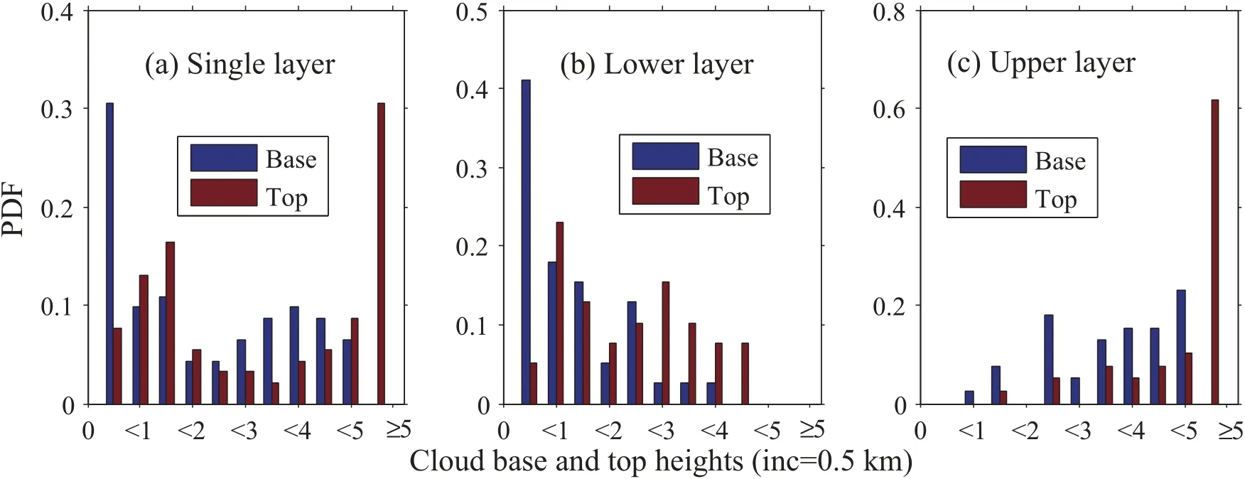
Fig.3.Probability density function(PDF)of cloud-baseheight(bluebars)and cloud-top height(red bars)for(a)single layer cloud,and(b)the lower layerand(c)upper layerof two-layer clouds.The stepw idth is0.5 km.
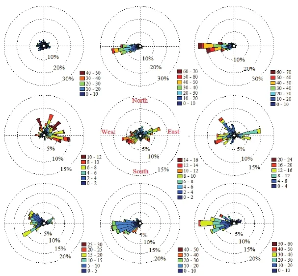
Fig.4.The occurrence frequency of horizontalw ind direction and speed below(left panels),w ithin(m iddle panels)and above(rightpanels)clouds.Top,m iddle and bottom plots denote single-layer cloud,and the lower and upper cloud of two-layer clouds,respectively.
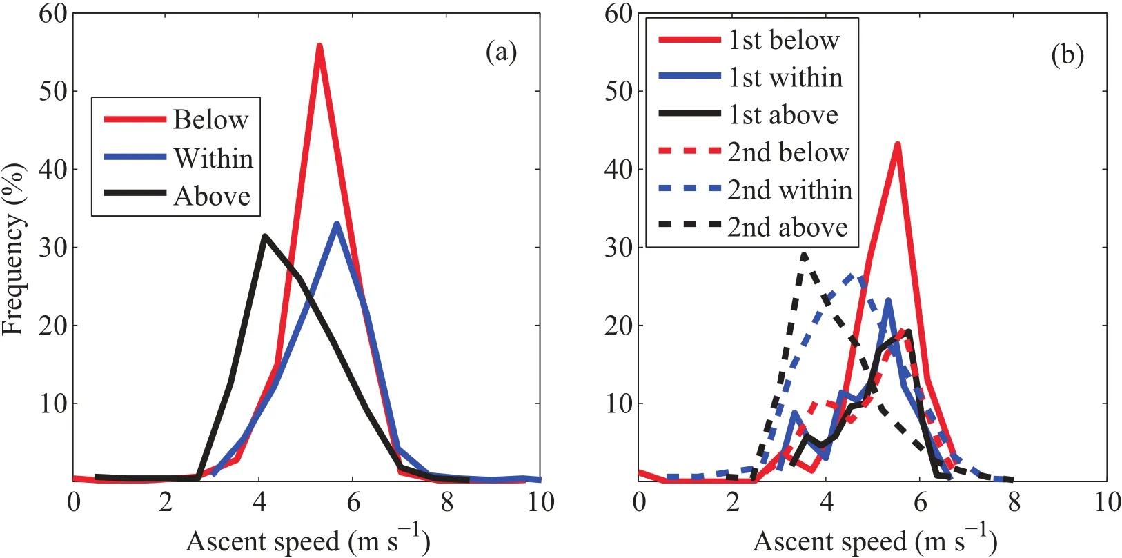
Fig.5.Frequency distributions of balloon ascent speed w ithin(blue line),below(red line)and above(black line)cloud for(a)single-layer cloud and(b)two-layer clouds.The solid linesand dashed lines in(b)represent lowerand upper cloud,respectively.
Figure 5 shows the frequency distributions of the balloon’sspeed ofascentbelow,w ithin and above the cloud.For the single-layer cloud(Fig.5a),there were large frequency distributionsbetween4and 6m s−1for theballoon’sspeed of ascentw ithin(72%)and below(84%)cloud.The frequency was 65%for the balloon’s speed of ascent ranging from 3 to 5 m s−1above the cloud.Themaximum frequencies of ascentspeed were 5.6,5.2 and 4.1m s−1w ithin,below and above the cloud.In general,the largestballoon ascentspeed was observed w ithin the cloud layers,followed by below the cloud,and finally above the cloud,which suggested the strongestupward flow occurred in the cloud.The balloon’s ascent speedswere less than 6 m s−1for 80%/77%w ithin single-low/m iddle clouds(figure not shown).The occurrence frequenciesof large ascentspeed episodes(>8m s−1) were 1%w ithin single-low clouds—two times larger than w ithin single-middle clouds.For two-layer clouds(Fig.5b), the balloon ascentspeeds derived from the lower-level cloud weregenerally larger than those from the upper-layer clouds, partly implying that the uplifted movementwas stronger in the lower atmosphere than at higher levels.It should also be noted that the smaller balloon ascent speed above the upper-layer cloud was due in part to an increase of balloon–radiosondeweightcaused by liquidwaterwetting.
The profi les of average balloon ascent speed and radiosonde-based vertical cloud occurrence frequency at a vertical resolution of 200 m from the surface to 4 km are shown in Fig.6.The vertical cloud occurrence frequency wasdefined as thenumberof radiosondesamplesdetecting a cloud or portion of cloud anywherew ithin a specified 200m bin divided by the total number of radiosonde samples during the AMF campaign period.Itcan be seen that the cloud occurrence frequency ranged between 17%and 25%.The cloud occurrence frequency increased from 0.2 to 0.7 km and reached amaximum(24.4%)at 0.7 km.Sim ilarly,Zhao et al.(2014)also foundmaximum cloud occurrence over Taihu Lake ata height close to 1 km.The balloon’s speed of ascentdecreased from the surface upwards to 0.3 km,and then an obvious increase occurred before reaching a maximum (5.3m s−1)at0.6 km.Themaximum balloon ascent speed was located in thevicinity of themaximum cloud occurrence frequency.Thiswas likely due to the occurrence of distinct upward motions typically ranging from 0.10 to 0.16 m s−1within the clouds,which was consistentw ith the results presented by Cotton and Anthes(1989).
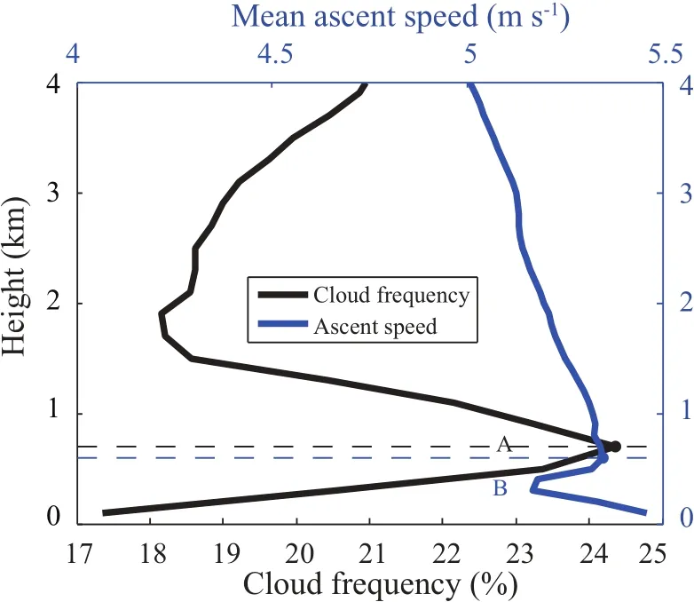
Fig.6.The relationship between cloud verticaldistribution frequency(black line)and theballoon’smean speed ofascent(blue line)asa function of detection altitude.Points A and B display the locations of themaximum cloud frequency and maximum ascentspeed.
3.3. Thermodynam ic features
The frequency distributionsof radiosonde-based temperaturegradientw ithin,below and above thecloud areshown in Fig.7.The temperature gradientevery 1000m was defined as(Ti+1−Ti)÷(Di+1−Di)×1000,where Diis the detecting altitude of a certain leveland Tiis the temperature of this level.Results for single-and two-layer clouds are shown in Figs.7a and b,respectively.The largest frequency was observed for the temperature gradient less than 5°C km−1for single-and two-layer clouds.Forsingle-layer cloud,the temperature inversion structures(>0°C km−1)occurredmostof-ten above the cloud layer,followed by below the cloud,and am inimum w ithin the cloud.For two-layer cloud configurations,the frequency distributionswere sim ilar between the two layers.The temperature inversion structures below and w ithin the cloud layeroccurred less frequently for the upper layer than the lower layer.However,the temperature inversion occurrence frequency above the cloudwas larger forupper cloud(16%)than for lower cloud(14%),which demonstrated that therewere stronger temperature inversion structures forupper clouds.
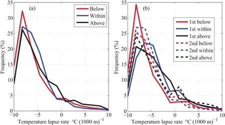
Fig.7.As in Fig.5 but for the temperature gradient.
Figure 8 displays two radiosonde-retrieved cloud cases and the temperature inversion structuresabove the cloud top. Gray areas in Figs.8a and c represent radiosonde-derived cloud layers,and rectangles outlined w ith red dashes denote temperature inversion locations.Figure 8a presents the single-layer cloud for the radiosonde launched at 0128 LST 15 November 2008 and Fig.8c shows the two-layer clouds obtained from the radiosonde launched at 0724 LST 8November2008.Figures8b and d show the cloudmask derived from the ARSCL around the radiosonde launch time in Figs.8aand c.Although therewas larger temporal variation for cloud locations and cloud thickness in the ARSCL data, the cloud layer structures obtained from the two distinctly different approaches agreed well.An obvious temperature inversion layerwas determined above the single-layer cloud (Fig.8a).The temperature inversion layer thickness(Tt),temperature inversion magnitude(Tm)(defined as the temperature difference collected at the top height and base height of the temperature inversion layer),and the temperature inversion gradientevery 100m(defined as Tm/Tt×100)were 415.1m,3.1°Cand 0.7°C(100m)−1,respectively.Therewas no noticeable temperature inversion layer for the lower-level cloud in two-layer clouds(Fig.8c).One thin temperature inversion layer was detected above the upper cloud top.The thickness,temperature inversionmagnitude and temperature inversion gradientwere90.1m,3.3°C and 3.6°C(100m)−1, respectively.It was evident that the temperature inversion structureswerewellderived by using the algorithm specified in section 2.
In terms of the radiosonde-based temperature inversion retrievals located above the single-layer cloud-top height, most of their thicknesseswere less than 200m,w ith a percentage of 85%and maximum thickness of~415 m.The inversion magnitude was generally less than 2°C and the maximum magnitudewas6.6°C.Theoccurrence frequencies were 57%and 20%for gradients less than 1°C(100m)−1and ranging from 1 to 2°C(100 m)−1,respectively.The average temperature inversion layer thickness,magnitude and gradient for all single-layer(low and m iddle)clouds were 117±94 m,1.3±1.3°C and 1.4±1.5°C(100 m)−1, respectively(Table3).Theoccurrence frequency of the temperature inversion was 71%above all single-layer clouds, whichwas80%(59%)above the single-low(m iddle)clouds. The average temperature inversionmagnitude was the same (1.3°C)for single-low and single-m iddle clouds;however,a largergradient[1.7±1.8°C(100m)−1]and smaller thickness (94±67 m)were detected above single-low clouds relative to those above single-m iddle clouds(Table 3).In terms of two-layer clouds,the temperature inversion layer occurrence number(frequency)above theupper cloud-top heightwas21 (54%),which was larger than 14(36%)obtained above the lower cloud-top height.Meanwhile,the temperature inversion layer thickness,magnitudeand gradientwerealso larger when presented by theupper layer[106±59m,1.0±0.9°C and 1.0±1.0°C(100m)−1]thanby the lower clouds[82±60 m,0.6±0.9°C and 0.7±0.6°C(100m)−1].In general,the temperature inversion structures above the cloud-top heights were strongerwhen presented by one layer than two;and as for two-layer clouds,they weremore strongly derived from the upper layer than the lower layer.Thismay be explainedby the radiative energy exchanges that affect the thermodynam ic state of cloud layers,as well as the interactions between the two layers of cloud.The em ission of infrared radiation at the top of a cloud w ill act to producemarked cooling around the top of the cloud layer(Chernykh and Eskridge,1996),which results in the temperature inversion structuresabove the cloud-top heightsof single-layerand the upper layer of two-layered clouds.However,this longwave radiative cooling effect is strongly reduced at the top of the lower layerof cloud in the presence of upper layersof cloud (Chen and Cotton,1987;Wang et al.,1999).The diurnal variation of temperature inversion structuresabove the cloud top at the AMF-China site(shown in Fig.9)was investigated based onmeasurementscollected from four radiosonde launches per day.Temperature inversion structuresoccurred most frequently at 1330 LST(32%)and least at 1930 LST (18%)for single-layer cloud.The patterns were sim ilar for frequency distributions obtained from the upper-levelcloud of two-layer clouds and the single-layer cloud,but the percentagewas larger for the former(43%)than the latter(32%)at noontime(1330 LST).More temperature inversion structures occurred at noontime and in the evening (1930 LST)for the lower-level cloud of two-layer clouds, and least in themorning(8%).Overall,the temperature inversion structures above the cloud top tended to occurmost frequently atnoontime forboth single-and two-layer clouds.

Fig.8.Radiosonde-retrieved temperature inversion structures above the cloud-top heights for cases of(a)single-and (c)two-layer clouds.Radiosonde vertical profi les of RH w ith respect to water,RH w ith respect to icewhen temperatureswere less than 0°C,and temperature are shown by the solid black line,the dashed black line,and the red line, respectively.Gray areas represent radiosonde-derived cloud layer boundaries,and rectangles outlined by red dashes denote temperature inversion locations.Panels(b)and(d)show the cloudmask obtained from the ARSCL around the radiosonde launch time corresponding to panels(a)and(c),respectively.

Table 3.Theoccurrence frequency,average temperature inversion layer thickness,magnitudeand gradient forallsingle-layer clouds(A ll), single-low cloudsonly(Low),single-middle cloudsonly(Middle),lower-layer(Lower)and upper-layer(Upper)of two-layer clouds.
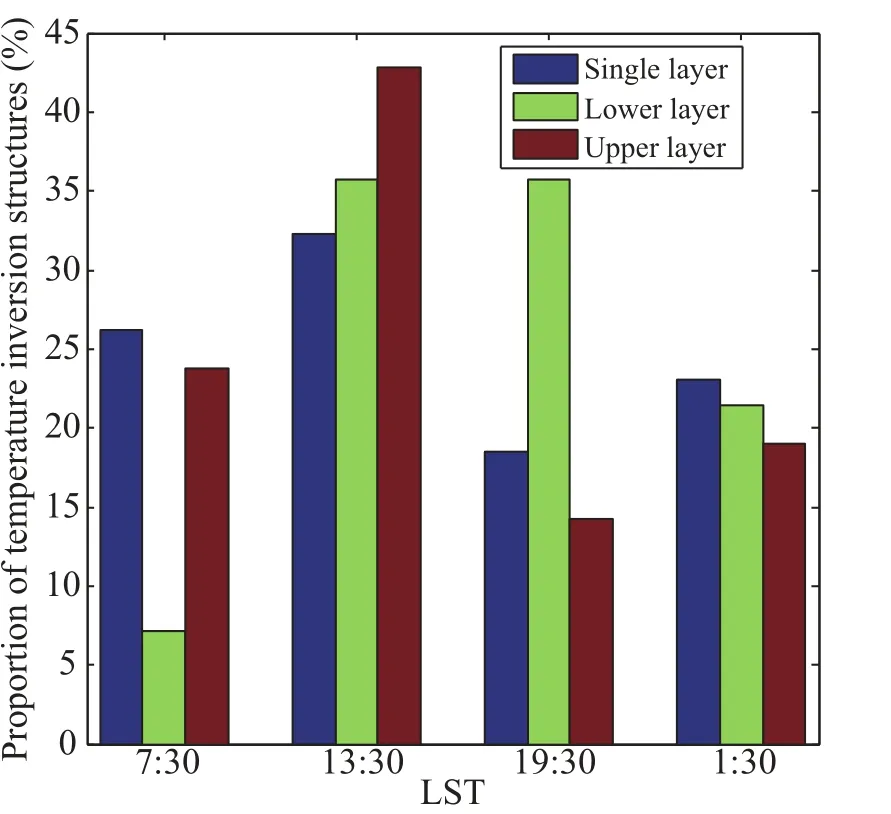
Fig.9.The proportion of temperature inversion structures located above the cloud-top heights occurring at four radiosonde launch times.The single-layer cloud,and the lower layer and upper layer of two-layer clouds are shown by the blue bars, green barsand red bars,respectively.
Themean temperature profi les under cloudy and cloudfree conditionsatnoontime(1330 LST)and nighttime(0130 LST)were also exam ined(figure not shown).About 50% of the cloudy skiesoccurred during thewarm months(June, July and August);meanwhile,mostof theclearskies(~51%) occurred during the coldmonths(Novemberand December). Becauseof theheterogeneousdistributionsof sky conditions, themean temperaturewashigher in cloudy skies than in clear skies from the surface to about12 km w ith amaximum difference at10.5 km.
Figure 10 shows themeanmonthly variationsof temperature at cloud-base height,cloud-top height,and cloud center leveland their distance from the 0°C height level for the single-and two-cloud layers.The temperaturewasgenerally higher than 0°C before October for single-layer cloud,and a sim ilarpatternwas revealed atcloud-baseheight,top-height, and cloud center level(Fig.10a).The structure of distance from the 0°C height level(Fig.10b)m irrored thatof temperature.For the lower layer of two-cloud layers(Figs.10c and d),the temperature(the distance from the 0°C height level) generally reachedmaximum(minimum)in August(November)for cloud-base height,top-heightand cloud center level. The temperatureof the upper layer(Fig.10e)was lower than 0°C at the cloud center and top levels duringmost seasons, which was higher than 0°C for the cloud base from May to October(Figs.10eand f).
3.4. CAPE,LCL and EL
The CAPEs derived from the AMF radiosonde data collected in Shouxian were mostly greater in the wet season than the dry season.Itwas found that99.5%of the CAPEs were smaller than 500 J kg−1in the dry season and 62% in wetmonths.The radiosonde-based lowest cloud boundarieswere compared w ith the LCL and EL calculated from the radiosondemeasurements during the entire AMF-China period.The cloud-baseheightsweregenerally located higher than the LCL,accounting for 68.5%.This should bemainly because the adiabatic assumption of airmass in calculating the LCL wasnotstrictly satisfied during the verticalmotion of stratiform layers.The correlation coefficientbetween the detected cloud-base heights and calculated LCL was 0.39. The relationship between the cloud-top heights and EL was also nothigh.Absolute differences between the cloud-base heightsand LCLwere less than 0.5 km for51.6%of the cases analyzed,whichwere less than 0.5 km for33.8%between the cloud-top heightsand theEL.Ingeneral,no clear relationship was found between the cloud-base height(cloud-top height) and LCL(EL).Thiswas likely because therewere very few cases of intense convection,which did not allow us to derive a clear relationship between the observational data and calculated convective parameters.The above comparisons were further conducted for the radiosonde samples collected in summermonths(June,July and August)when convective cloudsoften occurred.Relative to theentire AMF-China period,theiragreementwasmuchbetter in summerw ith theabsolute differences less than 500m between cloud-baseheight (cloud-top height)and LCL(EL)for 66.4%(36.8%)of the casesanalyzed.The AMF campaignsatShouxian lasted less than one year,so the above results associated w ith the convectiveparameterswereacquired from a relatively short-term period and thereby their representativeness needs to be thoroughly discussed in the future.Furtherstudy using long-term data collected at the ARMfixed stations is required.
4. Discussion and conclusions
The U.S.Departmentof Energy(DOE)ARM-AMFwas deployed at Shouxian,AnhuiProvince,China formore than seven months from 14 May to 28 December 2008.During theAMFcampaign,VaisalaRS92 radiosondeswere launched four times a day.The cloud vertical structures were derived from the radiosondemeasurements(Zhang etal.,2013). The present study focused on the dynam ic and thermodynam ic characteristics,including horizontal w ind speed,the balloon’s speed of ascentand the temperature structures,for single-and two-layered low and middle clouds.These dynam ic and thermodynam ic parameters w ithin-,below-and above-cloud were compared.Meanwhile,a few comparisonswerealso conducted between thesingle-low and singlem iddle clouds to discuss the potential dynamic and thermodynam ic differences in low andm iddle clouds.Highlightsofthe study’s findingsare summarized as follows:
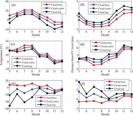
Fig.10.Themonthlymean variationsof(a,c,e)temperatureatcloud-baseheight(red line),cloud center level (blue line)and cloud-top height(black line),and their(b,d,f)distance from the 0°C height level for(a,b) single-layer cloud,and(c,d)the lower layerand(e,f)upper layerof two-layer clouds.
(1)The horizontal w ind speeds were larger above the cloud layers than thoseobserved w ithin and below the cloud for single-layer cloud.The frequency was 84%(52%)for w ind speeds of<10(>20)m s−1in single-low(m iddle) clouds.For two-layer clouds,the horizontal w ind speeds of the upper-layer cloud were generally higher than those of lower-layer retrievals.The prevailing w ind direction was westw ithin and above the cloud obtained from upper-and single-layer clouds.
(2)The largestballoon ascent speed was derived w ithin the cloud layers,followed by the rate below the cloud and above the cloud.More large ascent speed episodes(>8 m s−1)were observed in single-low clouds than in singlemiddle clouds.Themaximum balloon ascentspeed was5.3 m s−1,located in the vicinity of the layer w ith maximum cloud occurrence frequency(24.4%),suggesting upwardmotions(typically of 0.10–0.16 m s−1)occurred w ithin cloud layers.
(3)The average temperature inversion layer thickness, magnitude and gradientabove all single-layer(low andm iddle)clouds were 117±94 m,1.3±1.3°C and 1.4±1.5°C (100 m)−1,respectively.The average temperature inversion magnitude was the same(1.3°C)for single-low and single-m iddle clouds;however,a largergradient[1.7±1.8°C (100m)−1]and smaller thickness(94±67m)were detected abovesingle-low clouds relative to thoseabovesingle-m iddle clouds[0.9±0.7°C(100m)−1and 157±120m].For twolayer clouds,the temperature inversion parametersof theupper layer were 106±59 m,1.0±0.9°C and 1.0±1.0°C (100m)−1,respectively,which were larger than those of the lower-clouds[82±60m,0.6±0.9°C and 0.7±0.6°C(100 m)−1].In general,the temperature inversion structuresabove the cloud-top heightsof one-layer cloudswere stronger than thoseof two-layerclouds;for two-layer clouds,stronger temperature inversionswere observed for the upper layer clouds ascomparedw ith the lower layer clouds.This featureshould be associated w ith the radiative energy exchanges that affected the thermodynam ic stateof cloud layers,aswellas the interactions between the two layers of cloud.Temperature inversionsoccurredmost frequently atnoontime.
(4)The CAPE was greater during the wet season than the dry season.Absolute differencesbetween the cloud-base height(cloud-top height)and LCL(EL)were less than 0.5km for66.4%(36.8%)of the casesanalyzed in summer.
The dynamic and thermodynamic characteristics associated w ith the low and m iddle cloudswere discussed in this study.However,the2008AMFcampaignsatShouxian lasted less than one year,so the resultspresented in thisstudy were acquired from a relatively short-term period and thereby their representativenessneeds to be thoroughly discussed in the future.In addition to themobile facility,intensive and longterm(more than 10 years)measurements of surface and atmospheric quantitieshavebeen carried outat the fixed ARMsites,such as the U.S.SGP,northern slope of A laska,and tropicalwestern Pacific sites.Furthermore,as shown in previousstudies(e.g.,Protatetal.,2014;Zhang etal.,2014),the cloud retrievals from radiosonde,space-borne and groundbased remote sensing instruments have differentmerits and lim itations.As the nextstep,the long-term data(radiosonde and ground-basedmeasurements)collected from these fixed stationsw illbeused togetherw ith space-borne remote sensing measurements over these sites to comprehensively analyze the dynam ic and thermodynam ic characteristics associated w ith cloud layers to reveal their differences between cloud-free and cloudy sky conditions,especially their physical mechanisms,feedbacks,turbulence features and thermodynam ic structures.Finally,model simulationsw ith detailed aerosol–cloudmicrophysical interactionsarenecessary to improve cloud parameterizations in climate models and to understand the cloud formation process and life cycle of clouds,aswellas theirm ixingw ith theenvironment.
Acknow ledgements.The data employed in this study were made available by the ARMprogram sponsored by the U.S.DOE. Special thanksare extended to Prof.Zhanqing LIand Prof.Yuejian XUAN for theircontributionsto the ARMAMFcampaign atShouxian.We would also like to thank all the other participants in the AMF-China experiment.Thiswork was supported by the National Natural Science Foundation of China(Grant Nos.40975001 and 61327810)and the Special Fund for PublicWelfare Industry(Meteorology)(Grant No.GYHY201106046).WCW acknow ledges the supportof a grant(to SUNYA)from the Office of Science(BER), U.S.DOEand the Key NationalBasic Research Program on Global Change(GrantNo.2013CB955803).
REFERENCES
Bouniol,D.,F.Couvreux,P.H.Kamsu-Tamo,M.Leplay,F. Guichard,F.Favot,and E.J.O’Connor,2012:Diurnal and seasonalcyclesof cloud occurrences,types,and radiative impact overWest A frica.J.Appl.Meteor.Climatol.,51,534–553,doi:10.1175/JAMC-D-11-051.1.
Chen,C.,and W.R.Cotton,1987:The physics of themarine stratocumulus-cappedm ixed layer.J.Atmos.Sci.,44,2951–2977.
Chernykh,I.V.,and R.E.Eskridge,1996:Determ ination of cloud amount and level from radiosonde soundings.J.Appl.Meteor.,35,1362–1369.
Chernykh,I.V.,O.A.A lduchov,and R.E.Eskridge,2000:Trends in low and high cloud boundaries and errors in height determ ination of cloud boundaries.Bull.Amer.Meteor.Soc.,82, 1941–1947.
Clothiaux,E.E.,T.P.Ackerman,G.C.Mace,K.P.Moran,R.T. Marchand,M.A.Miller,and B.E.Martner,2000:Objective determination of cloud heights and radar reflectivities using a combination of active remote sensors at the ARMCART sites.J.Appl.Meteor.,39,645–665.
Cotton,W.R.,and R.A.Anthes,1989:Storm and Cloud Dynamics.Academ ic Press,San Diego,USA,883 pp.
Craven,J.P.,R.E.Jewell,and H.E.Brooks,2002:Comparison between observed convective cloud-base heights and lifting condensation level for two different lifted parcels.Wea.Forecasting,17,885–890.
Del Genio,A.D.,A.B.Wolf,and M.S.Yao,2005:Evaluation of regional cloud feedbacks using single-columnmodels.J. Geophys.Res.,110,D15S13,doi:10.1029/2004JD005011.
Doswell III,C.A.,and E.N.Rasmussen,1994:The effectof neglecting the virtual temperature correction on CAPE calculations.Wea.Forecasting,9,625–629.
Espy,J.P.,1841:The Philosophy ofStorms.C.C.Little and J. Brown,Boston,USA,552 pp.
Fan,X.H.,H.B.Chen,X.G.Xia,Z.Q.Li,and M.Cribb,2010: Aerosol optical properties from the Atmospheric Radiation Measurement Mobile Facility at Shouxian,China.J.Geophys.Res.,115,D00K33,doi:10.1029/2010JD014650.
Haeffelin,M.,and Coauthors,2005:SIRTA,a ground-based atmospheric observatory for cloud and aerosol research.Ann. Geophys.,23,253–275.
Illingworth,A.J.,and Coauthors,2007:Cloudnet–continuous evaluation of cloud profi les in seven operationalmodels using ground-based observations.Bull.Amer.Meteor.Soc.,88, 883–898,doi:10.1175/BAMS-88-6-883.
Intergovernmental Panel on Climate Change(IPCC),2007:The Physical Science Basis.S.Solomon et al.,Eds.Cambridge Univ.Press,Cambridge,U.K.,996 pp.
Intergovernmental Panel on Climate Change(IPCC),2013:The Physical Science Basis.Working Group IContribution to the Fifth Assessment Report of the Intergovernmental Panel on Climate Change,Summary for Policymakers.Stocker et al., Eds.,33 pp.[Available online at http://www.climatechange 2013.org/.]
Kalesse,H.,and P.Kollias,2013:Climatology of high cloud dynamics using profi ling ARMDoppler radar observations.J. Climate,26,6340–6359.
Kollias,P.,M.A.Miller,K.L.Johnson,M.P.Jensen,and D.T. Troyan,2009:Cloud,thermodynam ic,and precipitation in WestA fricaduring 2006.J.Geophys.Res.,114,D00E08,doi: 10.1029/2008JD010641.
Kunnen,R.P.J.,C.Siewert,M.Meinke,W.Schr¨oder,and K.D. Beheng,2013:Numerically determ ined geometric collision kernels in spatially evolving isotropic turbulence relevant for droplets in clouds.Atmospheric Research,127,8–21.
Li,Z.Q.,M.Cribb,F.L.Chang,A.Trishchenko,and Y.Luo, 2005:Natural variability and sampling errors in solar radiationmeasurements formodelvalidation over the Atmospheric RadiationMeasurementSouthern GreatPlains region.J.Geophys.Res.,110,D15S19,doi:10.1029/2004JD005028.
Li,Z.Q.,and Coauthors,2011:East Asian studies of tropospheric aerosolsand their impacton regional climate(EASTAIRC):An overview.J.Geophys.Res.,116,D00K34,doi: 10.1029/2010JD015257.
Mace,G.G.,and S.Benson,2008:The verticalstructure of cloud occurrence and radiative forcing at the SGPARMsite as re-vealed by 8 years of continuous data.J.Climate,21,2591–2610,doi:10.1175/2007JCLI1987.1.
Manzato,A.,2007.Sounding-derived indices for neural network based short-term thunderstorm and rainfall forecasts.Atmospheric Research,83,349–365.
Minnis,P.,Y.H.Yi,J.P.Huang,and J.K.Ayers,2005:Relationships between radiosonde and RUC-2meteorological conditions and cloud occurrence determ ined from ARMdata.J. Geophys.Res.,110,D23,doi:10.1029/2005JD006005.
Naud,C.,J.P.Muller,and E.E.Clothiaux,2003:Comparison between active sensor and radiosonde cloud boundariesover the ARMSouthern Great Plains site.J.Geophys.Res.,108, D44140,doi:10.1029/2002JD002887.
Poore,K.D.,J.H.Wang,and W.B.Rossow,1995:Cloud layer thicknesses from a combination of surface and upper-air observations.J.Climate,8,550–568.
Protat,A.,and Coauthors,2014:Reconciling ground-based and space-based estimates of the frequency of occurrence and radiative effect of clouds around Darw in,Australia.J.Appl. Meteor.Climatol.,53,456–478,doi:10.1175/JAMC-D-13-072.1.
Rickenbach,T.,R.Nieto Ferreira,N.Guy,and E.Williams,2009: Radar-observed squall line propagation and the diurnal cycle of convection in Niamey,Niger,during the 2006 African Monsoon and Multidisciplinary Analysis IntensiveObserving Period.J.Geophys.Res.,114,D03107,doi:10.1029/2008JD 010871.
Riihimaki,L.D.,S.A.McFarlane,and J.M.Comstock,2012: Climatology and formation of tropicalmidlevel cloudsat the Darw in ARMSite.J.Climate,25,6835–6850,doi:10.1175/ JCLI-D-11-00599.1.
Sassen,K.,and Z.E.Wang,2012:The clouds of themiddle troposphere:composition,radiative impact,and global distribution.Surveys in Geophysics,33,677–691,doi:10.1007/ s10712-011-9163-x.
Sherwood,S.C.,S.Bony,and J.L.Dufresne,2014:Spread in model climate sensitivity traced to atmospheric convective m ixing.Nature,505,37–42,doi:10.1038/nature12829.
Sobel,A.H.,S.E.Yuter,C.S.Bretherton,and G.N.Kiladis,2004: Large-scalemeteorology and deep convection during TRMMKWAJEX.Mon.Wea.Rev.,132,422–444.
Stephens,G.L.,2005:Cloud feedbacks in the climate system:A critical review.J.Climate,18,237–273.
Tao,W.K.,J.P.Chen,Z.Q.Li,C.Wang,and C.D.Zhang,2012: Impact of aerosols on convective clouds and precipitation. Rev.Geophys.,50,RG2001,doi:10.1029/2011RG000369.
Trenberth,K.,J.T.Fasullo,and J.Kiehl,2009:Earth’s global energy budget.Bull.Amer.Meteor.Soc.,90,311–324,doi: 10.1175/2008BAMS2634.1.
Wang,J.H.,andW.B.Rossow,1995:Determ ination of cloud vertical structure from upper-air observations.J.Appl.Meteor., 34,2243–2258.
Wang,J.H.,W.B.Rossow,T.Uttal,and M.Rozendaal,1999: Variability of cloud vertical structure during ASTEX observed from a combination of raw insonde,radar,ceilometer, and satellite.Mon.Wea.Rev.,127,2482–2502.
Wang,J.H.,W.B.Rossow,and Y.C.Zhang,2000:Cloud vertical structure and its variations from a 20-yearglobal raw insonde dataset.J.Climate,13,3041–3056.
Xi,B.K.,X.Q.Dong,P.Minnis,and M.M.Khaiyer,2010:A 10 year climatology of cloud fraction and vertical distribution derived from both surface and GOES observations over the DOE ARMSGP Site.J.Geophys.Res.,115,D12,doi: 10.1029/2009JD012800.
Zhang,J.Q.,H.B.Chen,Z.Q.Li,X.H.Fan,L.Peng,Y.Yu, and M.Cribb,2010:Analysis of cloud layer structure in Shouxian,China using RS92 radiosonde aided by 95 GHz cloud radar.J.Geophys.Res.,115,D7,doi:10.1029/2010JD 014030.
Zhang,J.Q.,Z.Q.Li,H.B.Chen,and M.Cribb,2013:Validation of a radiosonde-based cloud layer detection method against a ground-based remote sensing method at multiple ARMsites.J.Geophys.Res.,118,846–858,doi:10.1029/2012JD 018515.
Zhang,J.Q.,Z.Q.Li,H.B.Chen,H.Yoo,and M.Cribb,2014: Cloud vertical distribution from radiosonde,remote sensing, and model simulations.Climate Dyn.,43,1129–1140,doi: 10.1007/s00382–014-2142-4.
Zhang,M.H.,and Coauthors,2005:Comparing clouds and theirseasonalvariationsin 10 atmospheric generalcirculation models w ith satellitemeasurements.J.Geophys.Res.,110, D15,doi:10.1029/2004JD005021.
Zhang,Y.Y.,and S.A.K lein,2010:Mechanisms affecting the transition from shallow to deep convection over land:Inferences from observations of the diurnal cycle collected at the ARMSouthern Great Plains site.J.Atmos.Sci.,67,2943–2959.
Zhao,C.,and Coauthors,2011:ARMCloud Retrieval Ensemble Data Set(ACRED).DOE ARMtechnical report,DOE/SCARM-TR-099,Dep.of Energy,Washington,D.C.,28 pp. [Available online at http://www.arm.gov/publications/techreports/doe-sc-arm-tr-099.pdf.]
Zhao,C.F.,and Coauthors,2012:Toward understanding of differences in current cloud retrievals of ARMground-basedmeasurements.J.Geophys.Res.,117,D10206,doi:10.1029/2011 JD016792.
Zhao,C.F.,Y.Z.Wang,Q.Q.Wang,Z.Q.Li,Z.E.Wang, and D.Liu,2014:A new cloud and aerosol layer detection method based onm icropulse lidarmeasurements.J.Geophy. Res.,119,6788–6802,doi:10.1002/2014JD021760.
24 January 2015;revised 8April2015;accepted 16 June2015)
:Zhang,J.Q.,H.B.Chen,X.A.Xia,and W.-C.Wang,2016:Dynamic and thermodynamic features of low andm iddle clouds derived from Atmospheric Radiation MeasurementProgram mobile facility radiosonde data atShouxian, China.Adv.Atmos.Sci.,33(1),21–33,
10.1007/s00376-015-5032-8.
∗Corresponding author:Hongbin CHEN
Email:chb@mail.iap.ac.cn
杂志排行
Advances in Atmospheric Sciences的其它文章
- Variation in Summer Surface Air Tem perature over Northeast Asia and Its Associated Circulation Anomalies
- Ensemble Transform Sensitivity Method for AdaptiveObservations
- Observational FactsRegarding the Joint Activitiesof the Southwest Vortex and Plateau Vortex after ItsDeparture from the Tibetan Plateau
- Teleconnected Influenceof the BorealW inter Antarctic Oscillation on the Somali Jet:Bridging Role of Sea Surface Tem perature in Southern High and Midd le Latitudes
- Effectsof Surface Flux Parameterization on the Numerically Simulated Intensity and Structureof Typhoon Morakot(2009)
- Verification and Correction of Cloud Base and Top Height Retrievals from Ka–band Cloud Radar in Boseong,Korea
