气候系统与气候变化研究进展
2016-07-31
气候系统与气候变化
气候系统与气候变化研究进展
2016年,气候系统(极地气象)研究所在气候预测理论与方法、气候系统模式研发以及极地气候研究方面获得了显著进展。
1 气候预测理论与方法
1.1 GPCP和CMAP资料在东亚夏季风降水年际变率上的不一致性及其改进方案
揭示了GPCP和CMAP资料在北半球夏季风降水年际变率上的不一致性,提出基于两者算数平均减小该不确定性的方法和理由。GPCP和CMAP降水资料因覆盖全球范围和时间跨度较长而广泛用于气候监测和气候变率研究中。资料对比分析表明,尽管GPCP和CMAP资料均可描述北半球季风区降水的季节循环特征,但两者之间仍然存在明显的绝对误差,这种差异在5—10月的西北太平洋(WNP)季风区最为明显,表现为CMAP资料中WNP季风区夏秋季降水较GPCP资料数据偏多。就气候平均夏季降水的空间分布而言,两套资料的主要差异出现在WNP季风区的海洋上空,以及北非(NAM)和印度(IND)季风区的热带海域,这可能是CMAP资料使用了具有争议的岛屿观测资料。在年际尺度上,GPCP和CMAP资料在北半球五大季风区夏季降水年际变率方面大体一致,但两者在IND和NAF季风区的差异显著。GPCP和CMAP数据的一致性在近几十年逐渐提高,特别是在NAM和IND季风区。使用GPCP和CMAP的算术平均来描述北半球季风区降水的年际变率能够有效降低不同资料间的不确定性,特别是在1979—1997年的IND季风区和1998—2014年的NAF季风区(图1)。(祝从文,刘伯奇)
1.2 东亚夏季风气候季节内振荡的特征和可能成因
该工作证实了东亚夏季风气候季节内振荡(CISO)的存在性,阐明了与CISO位相循环相关主要环流系统的耦合过程和东亚夏季风降水季节内变化的联系。东亚夏季风(EASM)的气候季节内振荡以季风环流的垂向和经向相互作用为特征,与夏季风雨带的季节性北抬相联系。EASM CISO在5—8月最为强盛。采用谐波分析和多变量EOF分析方法,从逐日气候态(1981—2010年平均)风场、降水、非绝热加热以及海温场的季节内变化分析了EASM CISO主模态特征。结果表明,EASM CISO存在的根本原因是东亚地区海陆热力对比对太阳辐射年循环的非对称响应,使得CISO变率中心位于我国东部至西北太平洋上空。在EASM盛行季节,非绝热加热Q1主要由凝结潜热构成,Q1中心位于西北太平洋和东亚地区,因此Q1的水平梯度能够在其中心的东北侧制造负涡度源,其造成的背景上升运动有利于CISO的触发。同时,Q1各成分之间的位相差也能够维持EASM CISO。具体而言,EASM CISO开始于表面感热加热的加强,进而改变大气对流稳定度,调控季风对流及其凝结潜热,而凝结潜热的增加会令地面降温,感热减弱,如此循环往复,构成了EASM Q1 的CISO。
多变量EOF结果表明,EASM CISO的前两个主模态的主要特征是850 hPa贝加尔湖附近蒙古气旋、500 hPa西太平洋副高和200 hPa青藏高原上空南亚高压的相互耦合。其中第1主模态表现为上述3个环流系统的同时加强,对应着东亚地区“3极型”降水异常,即梅雨锋位于长江中下游至日本以南,而东北亚和西北太平洋的降水异常偏少。在EASM CISO的第2主模态中,蒙古气旋和西太平洋副高加强并向西北方向传播,而南亚高压却异常偏弱,与之对应的是亚洲到西太平洋地区的偶极型降水异常。而AGCM试验证明,EASM CISO的第1主模态主要与SST对大气环流的强迫作用有关,表现为东亚-太平洋地区逐日SST季节变化对大气环流季节演变的驱动作用,但EASM CISO的第2主模态却无法很好模拟,暗示该模态很可能与大气对SST的强迫过程有关(图2)。(祝从文,刘伯奇)
1.3 南海夏季风爆发年际变化特征及其海温影响因子在1993/1994年前后的年代际差异
揭示了南海夏季风爆发过程的年际变化特征在1993/1994年前后存在显著差异,指出春季南印度洋海温和前冬ENSO事件分别是1993/1994年前后影响南海夏季风建立时间的关键因子。南海夏季风爆发时间具有明显的年际变率。本研究依据南海夏季风爆发期间的动力热力场和环流结构的年际变化,以1993/1994年为界,将南海夏季风爆发的年际变化划分为两种不同类型。在1980—1993年期间,南海夏季风爆发年际变化的特征是季风降水异常出现在南海北部,伴随着显著的低空纬向风异常,将其定义为“Ⅰ型”爆发,它与副热带环流系统的联系更为紧密。在1994—2014年期间,南海夏季风爆发年际变化的特征变为以热带季风对流和高空纬向风异常为主,将其定义为“Ⅱ型”爆发。因此,南海夏季风爆发期间高、低空环流垂直耦合过程在这两个时段也具有明显差异。
影响南海夏季风爆发年际变化两种类型的前期SSTA也截然不同,对“I型”爆发而言,1983—1993期间南海夏季风爆发早晚主要受春季南印度洋(40°~20°S,40°~110°E)SSTA影响,南印度洋暖SSTA会导致南海夏季风爆发异常偏晚。这是因为南印度洋暖SSTA能够首先造成大尺度经向海平面气压异常,令南印度洋出现低空异常辐合,而低空异常辐散却位于南海地区,随后异常低空反气旋控制着南海北部,产生异常下沉运动,进而减弱南海地区的垂直东风切变和海陆热力对比,最终抑制了南海季风对流的发生,令南海夏季风爆发异常偏晚。对“Ⅱ型”爆发而言,在1994—2014期间,前冬ENSO事件及其相关的春季热带印度洋SSTA是影响南海夏季风爆发迟早的主要海温强迫。前冬暖ENSO事件发生后,能够通过“大气桥”造成春季热带印度洋的异常增暖。热带印度洋的异常增暖会激发出热带定常Kelvin波,令南海地区对流层中上部平均温度的经向梯度(MTG)减弱,从而推迟了MTG由冬到夏季节转换的时间。此外,对流层高层由热带印度洋吹向南海的大尺度东风异常使热带印度洋的上升运动加强,但却令南海南部的上升运动减弱,这将进一步抑制南海季风对流的建立,最终导致南海夏季风爆发异常偏晚。研究结果说明,ENSO和南海夏季风爆发时间之间的对应关系在1993/1994年前后发生了明显改变。这可能是因为在1993/1994年之后La Niña事件的发生频次明显提高,而这又与ENSO事件的年代际调整有关(图3)。(刘伯奇)
1.4 南亚高压季节变化是南海夏季风爆发的可能前兆信号
研究发现高空南亚高压的季节演变对南海夏季风的爆发具有指示意义,揭示了南海地区跨赤道季风环流建立的动力过程。南海夏季风爆发主要发生在每年的第28候(5月16—20日),以往的南海夏季风爆发研究主要基于对流层低层的大气环流和下垫面热状况研究南海夏季风的爆发机理(例如,西太平洋副高的东西移动和局地海温变化的影响)。利用NCEP/DOE R2大气再分析资料计算和分析了南海夏季风爆发前后的大气热动力过程,发现南亚高压在第27候的向东移动伸入南海上空很可能是导致南海夏季风爆发的主要诱因。第27~28候,随着南亚高压的东伸加强,南海上空出现正位涡平流,相应地局地高空上升运动加强,其导致的抽吸作用令低空西太平洋副高开始东撤出南海,季风槽和季风对流逐步建立;随着南海季风对流的不断加强,南亚高压持续东伸发展,与之对应的高空暖中心和近海面暖中心的空间位相叠加,南海地区的对流层温度垂直层结被破坏,从而满足了环流的角动量守恒条件,令季风环流的下沉支能够穿越赤道到达南半球,最终引起了跨赤道的季风经向环流,将南、北半球季风系统相联,南海夏季风最终于第29候完全爆发(图4)。(刘伯奇)
2 气候系统模式研发
2.1 东亚夏季降水结构模拟及其影响因子:2种不同类型大气模式对比
当前气候模式对东亚地区降水模拟存在普遍误差:东南部气候态降水偏少,北部地区气候态降水偏多;模式普遍高估降水频次,低估降水强度;对陆地午后日峰值的模拟普遍提前。研究指出,这些误差并非孤立存在,而是具有一定的内在联系。
研究对比了CAM5和SPCAM5模式的模拟结果,后者可以显式模拟次网格云降水等物理过程。研究指出,与大部分气候模式类似,CAM5具有以上误差特点。其中,CAM5对华南地区午后以16:00—17:00为主的峰值模拟偏早,主要集中在14:00这一午后不稳定最强的时刻。与此对比,SPCAM5缓解了华南地区的降水负偏差问题,降低了平均小时降水频次,提高了降水强度。同时,在以午后降水峰值主导的地区,SPCAM5延迟了降水峰值时刻。
为了明确造成两类模式模拟差异的原因,研究对模式的大尺度变量进行了小时尺度的源汇分析。针对Q1-Qrad的分析指出,SPCAM5在对流加热随时间演变的刻画上具有更明显的倾斜结构。针对Q2的分析指出,SPCAM5对降水峰值前的近地层变干信号具有更明显的表征。这反映了SPCAM5对于午后对流发展的渐进过程,即对流由浅对流至深对流的转换过渡阶段具有更合理的描述。
结合二者结果可以得出以下的物理图像。在CAM5中,每当有午后的不稳定能量出现,模式作出消耗不稳定能量的表现,开始降水,对流无法累积到一定的强度。因此,模式中以频繁的弱降水主导,且降水峰值提前,在气候平均态上表现为降水量偏低。在SPCAM5中,当有午后不稳定能量出现,模式不会立刻产生消耗不稳定能量的行为。模式能够模拟出对流由浅对流发展为深对流的演变阶段。浅对流云的存在使得模式不会快速形成降水,同时有助于不稳定能量的累积。当不稳定能量累积到一定程度时,降水峰值才出现。因此,降水峰值滞后,且峰值时刻降水量增强,降水频次降低,强度提高,在气候平均态上表现为降水量增多。因此,对流由浅至深转化这一过程的合理模拟,使得SPCAM5能够在一定程度上改善东亚地区降水在不同时间尺度上的特征。此外,由于降水峰值时刻对流更强,直接带来的一个副效应是峰值时刻的大尺度上升运动在SPCAM5中更强,这反映了次网格尺度过程对大尺度动力环流的影响。(张祎)
2.2 青藏高原陡峭地形处降水的模拟误差调节
针对大气环流模式在东亚降水模拟存在的一大顽疾“高原南坡陡峭地形区的降水偏差”,本研究发现这一问题对大尺度动力过程更为敏感。研究通过设计一组敏感性试验考察了这一问题。第1组试验为标准AMIP型气候积分的控制试验。第2组试验为敏感性试验,其中,人为的引入了一个与空气散度成正比的水汽散度项。这一项的引入使得空气辐散区的水汽被驱散,辐合区的水汽被堆积,与地形周边的散度效应恰好成对应关系。
通过长期气候积分发现,这一项的引入减少了模式在陡峭高地形区原本高估的降水,增强了模式在低地形区原本低估的降水,对模式在陡峭地形附近的降水误差呈抑制作用。此外,模式整体的降水频次-强度结构亦发生了变化,在陡峭高地形区的降水频次和强度值都有所降低。并且,总降水的主要变化来自于格点尺度降水和水汽含量的改变。这说明大尺度动力因子改变了局地的水汽结构,从而达到改变降水场模拟的结果。在非绝热水汽倾向上,这一水汽散度项表现为对高地形区原始正平流倾向的抑制,而对低地形区原始平流倾向的增加,这与模式气候积分结果相符。
为了能够更好地考察这一水汽散度项对模式的影响,进一步开展了气候模式的短期数值预报试验。该试验通过对模式进行短期的初始化预报构造模式的气候态,以考察短期误差和模式长期气候误差的联系。研究指出,这一散度项所带来的影响在很短的时间内即形成,是一个快过程变化。由于地形处的空气辐合辐散,高地形处的水汽随着该项的引入被“驱散”,低地形处的水汽随着该项的引入被“补充”。陡峭地形处水汽随大尺度动力因子的改变,影响了模式在该地区的降水特征。这一研究为消除模式在青藏高原地区的模拟误差提供了依据。研究也揭示出大尺度动力因子对降水的影响。(张祎)
2.3 正二十面体大气模式发展:传输与浅水方程求解器
为了适应面向未来的全球高分辨率大气模拟,研究发展了基于正二十面体剖分后形成的球面准均匀网格上的大气模式求解器。球面网格通过对一个规则正二十面体的三角边进行逐次等分所形成,并采用Voronoi-Delaunay球面拓扑划分构建为非结构型网格(区别于结构型正二十面体网格,不存在统一的拓扑规则)。求解器采用Arakawa-C网格,即质量位于单元格中心,正交预报速度位于单元壁。在罗斯贝半径得以分辨的前提下,C网格由于对散度模态的模拟优势,非常适合于模拟以散度模态为主导的高分辨率下的大气运动。同时,不同于Z网格,C网格无需求解椭圆方程,避免了全局通信,便于大规模并行。
传输和浅水方程包含了三维静力原始方程的水平部分。首先在正二十面体网格上构造了一个守恒两步保形平流方案(TSPAS),该方案是对Yu (1994年)两步保形平流方案在非结构网格上的有限体积推广。通过构造一个合适选取的预估参数,该方案可以灵活选择Lax-Wendroff和迎风格式以实现在保持精度的前提下的正定平流传输。本研究还构造了国际上广泛使用的通量纠正格式(FCT),并采用多个球面传输算例(刚体平移测试、变形流场测试等)对比了TSPAS和FCT方案。结果显示,两种方案都能够很好地实现非结构网格上的正定平流传输,TSPAS对单调性保持略佳,而FCT对信号峰值的保持略佳。本研究还指出了TSPAS和FCT在构造理念上的差异。
在传输方程的基础上,进一步构建了基于正二十面体C网格的球面浅水方程求解器。构造浅水方程,模式应满足一些重要且潜在的物理约束。对于广义形状的非规则C网格,其中重要的一点是对与预报风场成正交的科氏力项的近似,以避免切向力产生虚假的能量源汇。采用可严格保持科氏力能量中性的矢量重构算法,以及保证能量转换精确到时间截断误差的基本算子,构造了总能量守恒至时间精度的浅水方程求解器。通过采用多种时间积分方案,证实了这一求解器在能量方面的可靠性。该研究工作为后续研发奠定了基础。(张祎)
2.4 一种可客观评估模式降水的新方法及其适用性检验
在当前全球大气环流模式分辨率尚不足以分辨云动力尺度云雨演变过程的情况下,由参数化方案计算得到的模式降水只能表征模式格点尺度的平均降水。降水存在极大的时空非均匀性,这使得模式模拟降水与台站观测降水(固定点)和高分辨率卫星反演降水(小网格内的平均情况)难以进行直接比较,这一问题在评估降水小时尺度特征时会更为突出。本研究提出的应用一种新定义的区域降水事件(RRE)方法是客观评估模式对小时尺度降水特征模拟能力的有效手段。为验证该方法的适用性,首先比较了台站观测、小时融合降水产品(CMPA-Hourly)和两套常用卫星产品再现的中国中东部地区暖季(5—9月)小时降水特征。结果表明,与单站或单点比较不同的是,采用区域降水事件的方法比较不同源资料可以得到基本一致的降水频次与强度的空间分布特征,只是卫星反演降水在量值上与台站观测存在差异。基于单站或单点发现的卫星降水易于高估降水频次而低估降水强度的问题在使用该方法时有显著改进。同时,不同源观测资料均显示出暖季区域降水系数(RRC)分布的南北差异,即长江流域以南RRC相对较小,而以北区域则相对较大,表明该方法合理反映了暖季降水特性的区域差异,我国南方地区暖季对流降水频繁,而北方地区系统性的区域性降水更为频繁,这与此前研究的结论亦相一致。从日变化的角度看,卫星反演的降水频次和强度的日变化与台站观测降水也较为一致,基于区域降水事件考察不同资料间差异时未发现卫星资料对午后降水峰值的明显高估。整体而言,融合降水资料对中国中东部地区小时降水特征的再现要明显优于卫星反演降水。除了不同源资料的一致性外,该方法也能给出不用源资料对降水特性再现的差别。分析发现,在中国中东部地区,代表有限区域内降水空间分布的RRC在夜间至上午达日最大值,表明这一时段区域内降水分布最为均匀。在大部分地区,RRC达到日峰值的时间较区域降水事件强度的峰值时间滞后几个小时,表征了局地对流向层云降水转变的过程。在午后RRC较小,表明局地对流活动频繁,而对午后局地对流探测能力的不同可能是导致不同源资料对午后降水估计存在差异的重要原因之一。由于区域降水事件反映的是有限区域内的降水整体特征,采用该方法对不同源资料进行比较分析时卫星资料高估午后降水的特征不明显,以区域降水事件来分析卫星降水产品小时尺度降水特征亦具有更高的可信度。研究结果表明,区域降水事件是一种可用于比较不同源降水资料小时尺度特征的更合理方法,后续研究将进一步应用该方法评估数值模式模拟的云和降水时空变化特征(图5)。(陈昊明)
3 极地气候研究
3.1 夏季北冰洋中心大气边界层垂直结构与海冰范围变化的关系
最近的研究指出,北极海冰减少加强了北极大气边界层中海-冰-气相互作用,特别是秋季至初冬季海/气热通量的增加和边界层稳定度的下降。1999年以来中国实施了6次北冰洋科学考察。考察期间,开展了对大气垂直结构探测和海-冰-气相互作用的观测试验,使我们对北极浮冰区不同海冰密集度的大气边界层特征有了初步认识。研究指出,北极海冰区的大气逆温层能有效地阻碍大气与冰面之间的热量及物质交换。北冰洋大气边界层可分为稳定型、不稳定型和多层结构等类型,并发现来自高空较强的暖湿气流与冰面近地层冷空气强烈相互作用会形成强风切变和逆温、逆湿过程,从而导致北冰洋高纬度地区的大块海冰破裂。随着北极海冰的持续减少,2008年夏季中国第3次北极科学考察队到达北冰洋85°N海域,第4次北极科学考察队到达北极点附近(88.41°N),2012年第5次和2014年第6次北极科学考察队都到达了80°N以北冰区,使我们得以在北冰洋中心区冰站获取了GPS探空资料,为研究北冰洋高纬度对流层和边界层结构提供了重要基础。Ma等(2011年)和Bian等(2011年)分析了对流层和边界层逆温强度的变化特征,对北冰洋大气层边界层高度的变化特征提出了新认识。本研究利用中国第4~6次北极科学考察队获得的北极探空资料,对比分析北极夏季海冰面积变化对大气边界结构的影响,为研究北极海冰变化对大气环流的影响机理提供观测事实。
为了探索2010、2012和2014年夏季大气垂直结构、边界层高度参数差异的原因,分析了1979—2014年9月1000 hPa和850 hPa温度与海冰范围的变化关系,揭示出新的统计事实和它们的紧密关系,为深入研究北极海冰变化在全球气候变化中的作用提供了重要依据。主要结果如下:
(1) 2012年与2010和2014年夏季北冰洋中心区的对流层顶、边界层高度、温度递减率及风速和风向的垂直结构均在1 km以下存在明显差异,2010年和2014年近地面存在明显的逆温结构,2012年逆温层却很少出现,其过程与探测区域周围存在无冰海域和近地层气流较强的混合作用有关。2010和2014年夏季边界层高度与逆温强度呈显著的对数关系,相关系数分别为0.81和0.92,表明逆温强度越强,边界层高度越低。2012年二者对数关系相对离散,相关系数为0.56,边界层高度为690 m,明显高于2010年和2014年的边界层高度,反映了9月海冰范围的年际变化对大气边界层结构有重要影响。
(2)北极大气垂直结构除了受大尺度天气过程的影响外,与海冰覆盖范围的变化有直接关系:北冰洋中心区夏季的海冰面积越大,稳定层结的天气越多;反之对流性的天气增多。通过分析1979—2014 年9月北极海冰范围与1000 hPa和850 hPa温度变化的关系,发现近30年北冰洋中心区1000 hPa和850 hPa的温度变化呈显著的升高趋势,变化速率分别为1.3 ℃/10a和0.81 ℃/10a,与海冰范围呈负显著相关,相关数分别为0.83和0.74。结果表明,北极海冰减少,能够引起1000~850 hPa高度的大气层增温,这是海-冰-气相互作用的动力和热力输送结果。(丁明虎)
3.2 对2008—2013年间南极Dome A 表面物质平衡的再评估
2004/2005年,第21次南极考察在Dome A顶点安装了自动气象站,用于观测该区域的气象参数;2007/2008年,中国第24次南极考察队在Dome A 30 km×30 km区域内布设了49个花杆,用于测量该地区的数字高程、冰流速和表面物质平衡;2010/2011年和2012/2013年分别对各观测站点进行了复测。通过蒙特卡洛模拟,证明局部及区域尺度范围内表面物质平衡至少需要利用12~20个花杆点建立可靠的估计,因此本研究的观测方案可信度强。通过花杆观测数据计算了该区域的净物质平衡,为(22.9±5.9)kg/(cm2·a),远低于包含Dome C、Dome F和南极点在内的南极冰盖其他地区。结合气象站观测数据利用奥布霍夫-莫宁模型,模拟了该区域的升华和凝华状况,发现Dome A区域的升华损耗为(2.22±0.02)kg/(cm2·a)、凝华损耗为(1.37±0.01)kg/(cm2·a),即大约有14.3%的降雪量通过凝华形式损耗,远高于南极冰盖平均状况,这可能与该区域盛行下沉气流有关,对南极冰盖变化和雪冰芯研究具有重要的指示意义。另外研究发现,由于地形导致的下降风的原因,Dome A西部地区的冰盖雪密度与表面物质平衡要高于其他区域。本研究还建立并分析了Dome A数字高程模型,确认2个山峰穹顶均可以作为东南极冰盖的顶峰,修正了前人的结果。(丁明虎)
3.3 气候模式和地面观测中南极冰盖表面质量平衡的对比
本研究利用3265个多年平均的站点观测结果和29个逐年观测的观测数据对近些年出现的再分析资料和区域气候模式产品(ERA-Interim、JRA-55、MERRA、PMM5、RACMO2.1和RACMO2.3)在南极地区物质平衡的空间分布和年际变率进行检验。
自第1次国际极地年(1957—1958年)以来,世界各国科学家积极参与国际横穿南极科学考察计划(ITASE)和南极物质平衡和海平面研究计划(ISMASS),特别是国际极地年(2007—2009年)的一系列科学计划,对南极冰盖主要流域进行了大量表面物质平衡实地测量,采用的方法主要有花杆、超声高度计(雪深仪),雪坑、冰/雪芯和探地雷达法。Vaughan等 (1999年) 最早对表面物质平衡观测资料进行了编撰,建立了表面物质平衡空间数据库,但是其中包含了很多不可靠的数据,影响了表面物质平衡的空间分析及气候模式结果验证,为此Magand等(2004年)建立了南极积累率实测数据质量控制标尺。基于该标尺,Favier等 (2013年)对收集整理的南极物质积累率数据集进行了甄别筛选,在此基础上更新了该数据库。本研究广泛收集了冰芯、雪坑、自动气象站、物质平衡花杆观测资料,特别是国际极地年(2007—2009年)以来的最新研究成果,对Favier等(2013年)编撰的南极冰盖表面物质平衡数据集进一步更新,建立了具有3550个位置观测数据的经质量控制的南极冰盖多年平均表面物质平衡空间数据库。该数据库空间分布极不均匀,南极内陆和海岸许多区域仍然是数据空白区。
ERA-Interim、MERRA、CFSR、JRA-55和NCEP-2模式均能较好地模拟南极冰盖表面物质平衡大尺度空间变化,与实测结果相关系数超过0.75,但是模拟表面物质平衡中尺度变化能力有限,如在昭和站-Dome F断面,中山站-昆仑站断面,兰伯特冰川流域等 。所有这些再分析资料较好地再现了很多海岸区域表面物质平衡梯度,但是其模拟值通常偏高。JRA-25模式显著高估了东南极高原表面物质平衡,而ERA-Interim过低估计了表面物质平衡。总体上来说,由于对边界层潜热通量的高估,NCEP-2过低估计了表面物质平衡。MERRA、JRA-55和CFSR模拟结果与观测值比较一致,但是值得注意的是,所有再分析资料没有包含风吹雪导致的消融过程,说明这3种再分析资料在一定程度上高估了表面物质平衡。
1979—2012年,冰盖尺度上NCEP2、JRA-25、JRA-55、MERRA模拟的表面物质平衡呈显著增加趋势。CFSR和ERA-Interim模拟的表面物质平衡没有显著的变化趋势,这与基于冰芯记录重建的南极冰盖表面物质平衡结果一致。ERA-Interim线性变化趋势显著性水平达不到0.1检验水平的区域最为广泛。区域尺度上,尽管不同的再分析资料表面物质平衡趋势大小和方向差异显著,但是NCEP2、MERRA、JRA-25和JRA-55模拟的表面物质平衡在毛德皇后地海岸区域呈异常显著上升趋势,这与该区域的冰芯显示1989—2007年积累率呈下降趋势相左。在东南极70°~170°E区域内,再分析表面物质平衡变化资料趋势相近,如兰伯特冰川区和威尔克斯地岛中部呈上升趋势,而威尔克斯地岛西部和维多利亚地岛呈下降趋势。需要指出的是,JRA-25和NCEP2在威尔克斯地岛中部过高的上升趋势(>200 mm/a)令人怀疑。此外,除ERA-Interim模式外的Law Dome 显著上升趋势的再分析表面物质平衡与冰芯记录结果相矛盾。在西南极冰盖,1989—2009年,再分析表面物质平衡通常呈不显著变化趋势。在艾尔斯渥兹地(Ellsworth Land),ERA-Interim、CFSR、JRA-55和MERRA模拟的表面物质平衡呈上升趋势,这得到了该区域附近Gomez 冰芯记录的证实。所有再分析资料很好地再现了与罗斯海海冰范围增加有关的威尔克斯地岛表面物质平衡下降趋势。
从格点尺度上线性回归趋势来看,PMM5、RACMO2.1和RACMO2.3模拟的表面物质平衡具有显著性(p<0.05)线性变化趋势的区域都很有限。RACMO2.1模拟的表面物质平衡显著性变化趋势区域主要集中在毛德皇后地海岸区域和威尔克斯地岛部分区域,而RACMO2.3 模拟显著变化趋势区域集中在威尔克斯地岛和东南极内陆的部分区域,然而这些显著趋势区域并没有得到冰芯记录结果的证实。1979—2012年,南极冰盖尺度上PMM5和RACMO2.1模拟的表面物质平衡没有显著的变化趋势,但是RACMO2.3呈显著的下降趋势。29个具有区域代表性表面物质平衡实测序列与相应的PMM5、RACMO2.1和RACMO2.3模拟结果的相关分析表明,有15个点RACMO2.3模拟结果与实测表面物质平衡序列显著相关,而RACMO2.1和PMM5模拟结果与实测显著相关的点少于10个。总的来说,与再分析资料相比,区域气候模式模拟的南极冰盖表面物质平衡年变化趋势可信度不高,这很可能是其内部由于没有同化观测数据限制任由模式自由演化导致的。未来在这些模式长期积分中引入松弛逼近方法或谱逼近方法等进行动力降尺度有望改进模拟表面物质平衡年际变化的能力。(丁明虎)
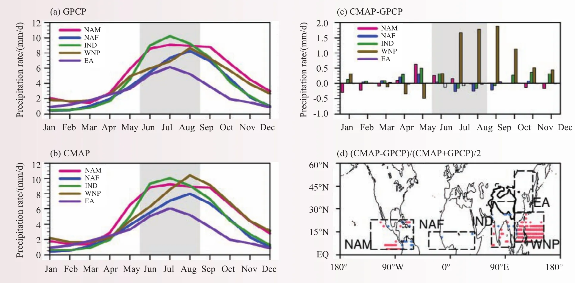
图1 GPCP(a)和CMAP(b)资料计算的北半球五大季风区气候平均降水的季节循环特征,以及两者季节循环的绝对偏差(c)和两者夏季降水的相对偏差(d)(红点表示>30%; 蓝点表示<-30%,虚线框表示两者一致的季风区范围,黑色等值线表示1.5 km的青藏高原范围)Fig. 1 Climatological seasonal cycle of precipitation (1979–2014) calculated based on (a) GPCP and (b) CMAP (unit: mm d−1)products over the f ve monsoon regions as marked in (d). (c) Absolute difference in the averaged seasonal cycle between the two products (CMAP minus GPCP; unit: mm d−1). (d) Relative difference of the averaged summer precipitation between the two products (0.5 × (CMAP−GPCP) × (CMAP + GPCP)−1; red: >30%; blue: <−30%). The black contoured region is the 1.5 km topography of the TP
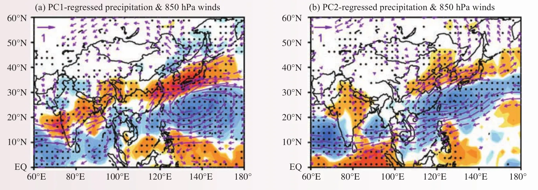
图2 与东亚夏季风(EASM)气候季节内振荡(CISO)前2个主成分有关的季节内降水(阴影,mm/d,打点区表示通过90%信度检验)和850 hPa风场(矢量,m/s,通过90%信度检验的部分)的回归场Fig. 2 Regressed intraseasonal anomalies of precipitation (shading, mm d-1; values exceeding 90% conf dence level are stippled)and 850 hPa winds (vectors, m s-1; vectors exceeding 90% conf dence level are plotted) associated with the first two MV-EOF modes of winds related to EASM CISO
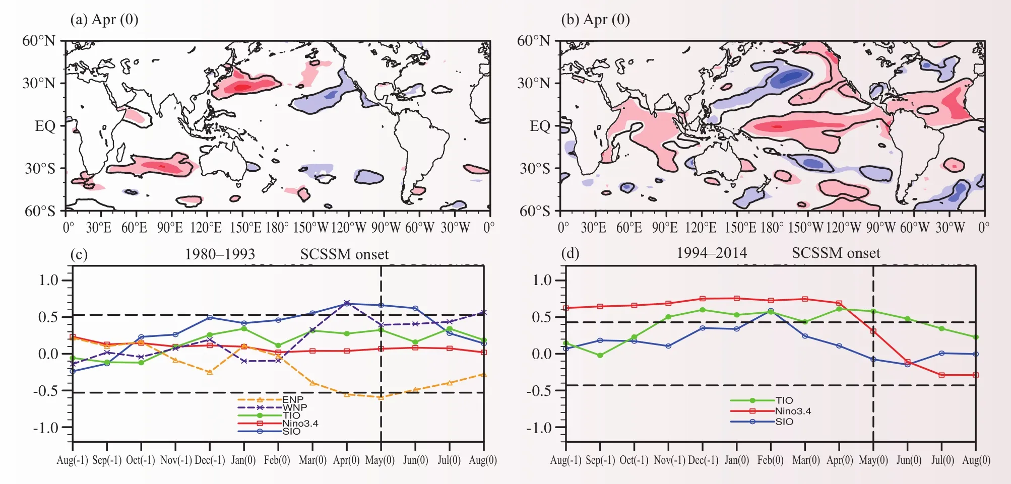
图3 不同年代影响南海夏季风爆发时间的春季海温关键区(K)(a,b)及其季节变化(c,d)(a,c:1980—1993年;b,d:1994—2014年)Fig. 3 (a, b) Spring SSTA (K) and (c, d) its seasonal evolution (represented by the correlation coefficient between the regional mean SSTA and the SCSSM onset time) associated with the SCSSM onset time during (a, c) 1980–1993 and (b, d) 1994–2014,respectively
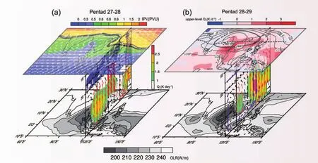
图4 南海夏季风爆发进程示意:(a)第27~28候(上:360 K等熵位涡(阴影,PVU)和风场(矢量,m/s);中:非绝热加热(阴影,K/d)、正位涡平流(等值线,10-5PVU/s)和垂直运动(矢量,加粗箭头表示高空上升运动,10-2Pa/s);下:OLR(W/m2));(b)第28~29候(上:对流层上部非绝热加热(阴影,K/d)和气温(K);中:非绝热加热(阴影,K/d)和季风经圈环流(矢量,紫色箭头表示跨赤道季风环流圈,m/s);下:OLR(W/m2))Fig. 4 Schematic diagram of the SCSSM onset process. (a) Pentad 27–28 (upper panel: 360 K isentropical potential vorticity(shading, PVU) and winds (vectors, m s-1); middle panel: diabatic heating (shading, K day-1), positive advection of potential vorticity (contours, 10-5PVU s-1) and vertical motion (vectors, heavy ones represent the upper-level ascending, 10-2Pa s-1) over the SCS (averaged along 110°–120°E); low panel: OLR (W m-2)). (b) Pentad 28–29 (upper panel: diabatic heating (shading, K day-1) and air temperature (contour, K) in the upper troposphere (averaged bween 400–200 hPa); middle panel: diabatic heating(shading, K day-1) and meridional monsoon circulation (vectors, purple ones are for the cross-equatorial monsoon circulation, m s-1); low panel: OLR (W m-2))
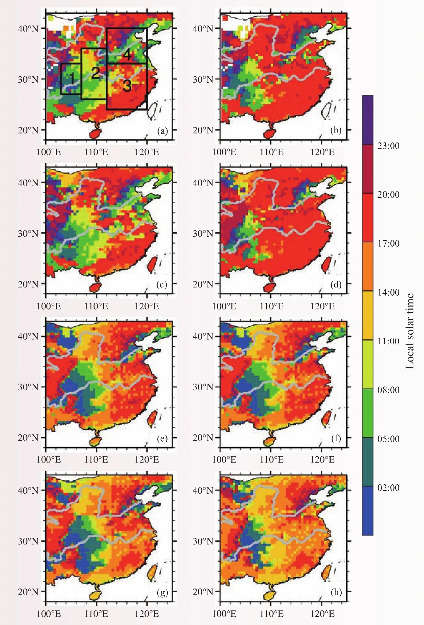
图5 2008—2013年暖季(5—9月)平均的区域降水事件强度(左)和频次(右)的日峰值位相(当地时间)分布(从上往下依次为台站观测(a~b),CMPA-Hourly融合降水(c~d),TRMM 3B42(e~f)和CMORPH(g~h);灰色实线为长江和黄河的位置)Fig. 5 The diurnal phase (local solar time) of the 2008−2013 warm season (May−September) mean intensity (left column) and frequency (right column) of RRE from rain gauges (a-b), CMPA-Hourly (c-d), TRMM (e-f) and CMORPH (g-h) products. The locations of the Yellow and Yangtze rivers are marked by gray lines
Progress in Climate System and Climate Change Research
In 2016, the Institute of Climate System (Polar Meteorology) has achieved remarkable improvements in the fields of (1) theory and methodology of climate prediction, (2) development of climate system model, and (3)polar climate.
1 Theory and methodology of climate prediction
1.1 The inconsistency of interannual rainfall variability of boreal summer monsoon between GPCP and CMAP precipitation products and an improvement scheme
This work has revealed the discrepancy between GPCP and CMAP precipitation products in terms of the seasonal and interannual variations of boreal summer monsoon rainfall, and the arithmetic mean of the two products is shown to reduce such uncertainties. GPCP and CMAP precipitation products with global coverage and long record length have been widely used to monitor the climate status and study the climate variability.Our recent work has pointed out that although the GPCP and CMAP products are able to describe the seasonal cycle of rainfall in the boreal summer monsoon region, the absolute error between them is still evident. In particular, the difference in rainfall amount is largest from May to October in the western North Pacific(WNP) monsoon region, presenting more summer and autumn rainfall in the GPCP product. As to the spatial distribution of the climatological mean summer precipitation, the most prominent difference between the two datasets appears over the ocean portion in the WNP, North Africa (NAF) and Indian (IND) monsoon region. It is likely due to the controversial use of atoll gauges over the tropical Pacific in CMAP.
In the interannual timescale, the interannual variabilities of summer precipitation in GPCP and CMAP products are generally consistent over the boreal summer monsoon region, but the evident discrepancy appears over the IND and NAF monsoon regions. The consistency between CMAP and GPCP has increased in the recent decades, especially over the NAM and IND monsoon regions. Further analysis shows that the arithmetic mean of CMAP and GPCP products is an effective method to reduce the uncertainties. The improvement is mostly evident over the IND monsoon region during 1979–1997 and the NAF monsoon region during 1998–2014 (Fig.1). (Zhu Congwen, Liu Boqi)
1.2 The climatological intraseasonal oscillation in the East Asian summer monsoon and its possible mechanisms
The existence of climatological intraseasonal oscillation (CISO) in the East Asian summer monsoon(EASM) has been validated in this work. We have also revealed the CISO-related primary circulations and their coupling process, as well as its association with the EASM precipitation on the intraseasonal timescale.
The climatological intraseasonal oscillation (CISO) of the East Asian summer monsoon (EASM) is characterized by the vertical and meridional interactions of monsoon circulation, with a stepwise northward shift of front-related rain belt during boreal summer, particularly from May to August. To reveal the vertical structure and the internal modes of the EASM CISO, as well as their interaction with the surrounding SSTs, we conducted harmonic and multivariate empirical orthogonal function (MV-EOF) analyses on the climatological daily winds, rainfall, diabatic heating, and SST for the period 1981–2010. The EASM CISO exists not only in diabatic heating, primarily contributed by condensational heating, but also in rainfall and circulation. TheEASM CISO mainly results from the asymmetric response of the land-sea thermal contrast over East Asia to annual solar forcing. As a result, the center of the CISO variability is located over eastern China and the western North Pacific. During the EASM season, the Q1 is mainly associated with condensational heating and is centered over the WNP and East Asia. Thus, the horizontal gradient of Q1 produces a negative vorticity source to the north and east of the Q1 center. The resultant local background ascending motion favors the initiation of the CISO. Moreover, the EASM CISO can also be initiated and maintained by the different phasings of various diabatic heating (Q1) components. Namely, the CISO is initated by changes in surface sensible heat flux, which modulates the atmospheric convective instability, and thus the variations of monsoon convection and the condensational heating. The changes in condensational heating in turn would affect land surface temperature through radiative forcing. This eventually would lead to changes in surface sensible heating flux, and so on.
Results based on the MV-EOF analysis reveal that the first two modes of the EASM CISO are mainly characterized by the coupling of the Mongolian Cyclone (MC) around Lake Baikal at 850 hPa, the WNP subtropical High (WNPSH) at 500 hPa, and the South Asian High (SAH) over the Tibetan Plateau (TP) at 200 hPa. The first leading mode shows a simulteneous enhancement of the MC, WNPSH, and SAH, accompanied by a tripole rainfall anomaly of the strong Meiyu and Baiu fronts around the lower reaches of the Yangtze River and southern Japan, whereas the rainfall was suppressed over northeastern Asia and the WNP. The second leading mode, which indicates the eastward and northwestward propagation of the enhanced MC and WNPSH with the weakened SAH, is associated with a dipole of the rainfall anomaly, with abundant and deficient rainfall over the northeastern and southeastern Asia-Pacific regions, respectively. In this study, we also performed the AGCM simulations forced by daily SST from 1981 to 2010 using the ECHAM5.4 at the resolution of T63L31.The results show that the simulated first CISO leading mode is consistent with the observed, suggesting the critical role of seasonal variations of daily SST in the EASM CISO over the Asia-Pacific region. However, the AGCM runs failed to realistically reproduce the second CISO leading mode. The MC CISO is well reproduced by the AGCM, but the simulated CISO of the WNPSH and SAH is poor compared with the observations likely owing to the lack of feedback of SST to the atmospheric forcing (Fig. 2). (Zhu Congwen Liu Boqi)
1.3 The difference of interannual variation of South China Sea summer monsoon onset and itsrelated SSTs before and after 1993/1994
We have found the distinct differences of interannual variation of South China Sea summer monsoon(SCSSM) onset before and after 1993/1994. It is shown that the SSTA in the southern Indian Ocean in spring and the ENSO in previous winter are key factors in determining the SCSSM onset time before and after 1993/1994, respectively.
Based on their distinct thermodynamic field and circulation structures, we have identified different behaviors of the interannual variability of SCSSM onset in the periods 1980–1993 and 1994–2014. Our results suggest that the interannual variability of the SCSSM onset during 1980–1993 is characterized by rainfall anomalies over the northern SCS and evident anomalous zonal wind in the lower troposphere. This is defined as type-I SCSSM onset, presenting a closer association with subtropical systems. During 1994–2014, the interannual variability of the SCSSM onset is determined by the anomalies of tropical convection and the upper-tropospheric zonal wind, which is herein referred to as type-Ⅱ SCSSM onset. As a result, the vertical coupling between the upper- and lower-level circulations differs between type-I and type-Ⅱ SCSSM onsets on the interannual time scale.
The interannual variability of SSTAs in boreal spring is also distinct in the two types of SCSSM onsets.In the type-I SCSSM onset, the interannual variability of the SCSSM onset time is controlled by the springSSTAs in the South Indian Ocean (SIO, 40°–20°S, 40°–110°E) during 1980–1993, whereas it is affected by the winter ENSO and spring Tropical Indian Ocean (TIO) SSTAs in the type-II SCSSM onset during 1994–2014, on the interannual time scale. In the 1980–1993 period, the warm SIO SSTAs in spring can delay the SCSSM onset. In this process, the warm SIO SSTAs first produce a large-scale meridional dipole pattern, with anomalous convergence over the SIO and divergence over the SCS in the lower troposphere, bridging via the cross-equatorial flow near 90°E. Then, an anomalous anticyclone forms over the northern SCS, leading to the anomalous descent over the northern SCS and ascent over the land to its north. Subsequently, the vertical easterly shear and meridional land-sea thermal contrast weaken such that they suppress convection associated with the monsoon onset over the SCS and the SCSSM onset is postponed. During the 1994–2014 period, both winter ENSO events and spring TIO SSTAs are closely related to the interannual variability of the SCSSM onset time. A warm ENSO event during winter can induce the warm TIO SSTAs in the following spring via the atmospheric bridge. Subsequently, the meridional temperature gradient (MTG) in the mid- to uppertroposphere weakens over the SCS due to the tropical stationary Kelvin wave stimulated by the warm TIO SSTAs, and this delays the seasonal transition of the MTG from winter to summer. In addition, the anomalous large-scale westerly in the upper troposphere blows from the TIO to the SCS, with the anomalous ascending and descending branches over the TIO and SCS in the tropics, respectively. Consequently, the anomalous descent and weakened zonal easterly shear could suppress convection associated with the monsoon onset over the southern SCS, leading to the late onset of the SCSSM.
The present results also imply an abrupt change in the relationship between ENSO and the timing of the onset of the SCSSM before and after 1993/1994. In fact, the El Niño events of previous winters are followed by a late onset of the SCSSM in both periods, and the closer association between ENSO and the SCSSM onset time and the early SCSSM onset in the recent period after 1993/1994 may be attributed to the more frequent La Niña events, which may be related to the interdecadal adjustment of the ENSO after 1993/1994 (Fig. 3). (Liu Boqi)
1.4 The seasonal evolution of the South Asian High is a possible precursor for the onset of the South China Sea summer monsoon
The seasonal evolution of the South Asian High (SAH) has been suggested to be a precursor for the South China Sea (SCS) summer monsoon onset. We have also revealed the dynamical process that is responsible for the establishment of the cross-equatorial monsoon circulation over the SCS.
The averaged onset time of the SCS summer monsoon (SCSSM) is pentad 28 (16−20 May). Previous studies on the SCSSM onset have focused on the influences of the lower tropospheric circulation and the underlying thermal condition on the SCSSM onset. In the present study, we have used the NCEP/DOE reanalysis data to diagnose the thermal and dynamical processes during the SCSSM onset. It is found that the major incentive for the SCSSM onset is the eastward extension of the SAH to the upper troposphere of the SCS. During Pentad 27−28, the positive potential vorticity advection takes place over the SCS, along with the eastward development of the SAH. Accordingly, the upper-level ascending motion is enhanced, making the low-level western North Pacific subtropical anticyclone to withdraw eastward away from the SCS, followed by the initial formation of the monsoon trough and the onset of monsoon convection. Later, the monsoon convection over the SCS deepens gradually, resulting in the continuous eastward development of the SAH. The near-surface warm SST is overlaid by the upper-level warm center associated with the SAH. Such a thermal configuration implies a destruction of the vertical thermal stratification over the SCS, which satisfies the condition of absolute angular momentum conservation (AMC). As a consequence, the ascending motion over the SCS is able to cross the equator and reaches the Southern Hemisphere, and finally induces the closed cross-equatorial monsoon circulation that bridges the monsoon systems in the two hemispheres on Pentad 29 after the SCSSM builds up completely (Fig. 4). (Liu Boqi)
2 Development of climate system model
2.1 Comparing simulations and impact factors of precipitation characteristics over East Asia in two different atmospheric models
Current climate models have common biases in simulating precipitation over East Asia. They tend to underestimate the precipitation amount over southeastern China, overestimate the precipitation amount over northern China, and overestimate the precipitation frequency while underestimate the precipitation intensity,and often simulate the afternoon continental precipitation peak too early. These biases are not isolated problems but intimately correlated.
The study compared the CAM5 and Super-Parameterized CAM5 (SPCAM5) simulations of summer precipitation characteristics. SPCAM5 can explicitly simulate cloud and precipitation processes in a GCM’s grid column. Results show that CAM5 posesses those aforementioned biases. Especially, over southeastern China, the precipitation peak in CAM5 appears at around 14:00 local solar time, when the unstable condition reaches the maximum. However, in the observation, the precipitation peak occurs at around 16:00–17:00. In contrast, SPCAM5 alleviates the negative precipitation biases over South China, reduces the precipitation frequency while enhances the precipitation intensity. Moreover, over regions dominated by the afternoon precipitation peak, SPCAM5 delays the precipitation peak time by a few hours, closer to observtions.
To f gure out reasons for these differences in the model performances, we conducted a source/sink budget analysis by calculating the residuals of large-scale state variables. Results from the Q1-Qrad analysis indicate that SPCAM5 more evidently simulates the progressive evolution of convective heating, which exhibits a tilting structure in the pressure-time transect. The Q2 analysis indicates that SPCAM5 more evidently simulate the drying signal occurring before the intense precipitation starts. These reflect the fact that SPCAM5 better simulate the transition from shallow to deep convection.
Based on the aforementioned analysis, we can draw the following conclusions. In CAM5, when the unstable energy occurs in the afternoon, the model will quickly release the unstable energy through deep convection so as to stabilize the model atmosphere. In this case, precipitation appears quickly in the model and convection cannot be accumulated to certain strength. As a result, the model produces more frequent but less intense rain. In SPCAM5, the model will not instantly remove the unstable energy once the atmosphere becomes unstable. Instead, the model simulates a process in which convection progressively develops from shallow to deep convection. Shallow cumulus clouds inhibit precipitation and help the unstable energy to grow to a higher magnitude. At certain threshold, the precipitation occurs and reaches the maximum at a relatively late stage. Therefore, in SPCAM5, the peak is delayed and accompanied by more intense precipitation. The model atmosphere rains less frequently with higher intensity, and exhibits increased precipitation amount in terms of the climatology. Hence, it is the proper simulation of the transition from shallow to deep convection that helps SPCAM5 to improve the simulations of precipitation characteristics. Meanwhile, because convection becomes more intense near the peak time, a related effect is that the large-scale upward motion becomes stronger during the precipitation peak in SPCAM5. This reflects the impact of sub-grid scale convection on the large-scale dynamics. (Zhang Yi)
2.2 Regulating the precipitation errors along the steep slope of the Tibetan Plateau
A stubborn model bias over East Asia in GCMs, namely, the precipitation errors along the shouthern steepslope of the Tibetan Plateau, was investigated in this study. Results suggest that this problem is more closely related to the large-scale dynamics. Two contrasting model experiments were designed in this study. The first experiment is a typical AMIP style climate integration. In the second experiment, a moisture divergence term is artificially added to the model’s moisture transport equation. With this term added, moisture over the convergent area will be continuously accumulated, while moisture over the divergent area will be gradually removed.
Results show that this additional term well reduces the originally overestimated precipitation amount at the higher part of the steep slope, while enhances the originally underestimated amount at the lower part of the steep slope. Moreover, the entire precipitation frequency-intensity structure was also modulated. The changes in the total precipitation mainly result from the changes in the grid-scale precipitation and moisture contents.This reflects that the large-scale dynamics modulates the local moisture content and regulates the precipitation simulation. By checking the adiabatic moisture tendency, we confirm that this additional term inhibits the original positive moisture advection tendency at the high part, while enhances the tendency at the low part, in accordance with the differences in the simulated precipitaiton climates.
To better understand the impact of this term on the model performance, we conducted numerical weather prediction type experiments. Results show that this term quickly exerts an influence on the precipitation simulation, namely, it is a fast adjustment process. Moisture contents over the higher part are largely removed,while those over the lower part are significantly enlarged. The change of the moisture content in fluences the precipitation characteristics over the steep slope region. This study offers useful information for suppressing the simulation errors around the Tibetan Plateau. It also reveals the impact of large-scale dynamics on the precipitation simulations. (Zhang Yi)
2.3 Development of an icosahedral atmospheric model: Solvers of transport and shallow water equations
To accommodate the requirement of developing global high-resolution atmospheric models in the future,we are conducting research to solve the atmospheric model equations based on a quasi-uniform mesh obtained from a subdivided icosahedron. The spherical mesh is formed by recursively bisecting each triangular edge of a regular icosahedron. The mesh is further divided into the Voronoi-Delaunay diagram such that an unstructured mesh is achieved. This differs from the structured icosahedral mesh in that there is no uniform topological rule for the grid. The solver utilizes the Arakawa-C staggering grid system, namely, the mass is defined at the cell center and the normal velocity is located at the cell edge. When the Rossby deformational radius can be well resolved, the C-grid system is very suitable for simulating the resultant high-resolution atmospheric motions because of its advantage in depicting the divergent mode. Meanwhile, unlike the Z-grid, a C-grid model does not need to invert an elliptic equation, thus avoiding the massive global communication and favoring the massive parallel computation.
The transport and shallow water equations constitute the horizontal part of a global 3D model. We first built a conservative Two-step Shape-Preserving Advection Scheme (TSPAS). This can be viewed as a finitevolume and unstructured extension of the scheme in Yu (1994). By designing a properly defined pre-integration parameter, this method selects between the Lax-Wendroff and the upwind scheme to maintain a positive definite transport with the minimum loss ofinumerical accuracy. We also constructed a famous and widely used positive definite transport scheme called “Flux Corrected Transport (FCT)”, and compared TSPAS with FCT using various transport experiments. Results show that both schemes fulf ll the demand of a positive definite transport. TSPAS retains more monotone solutions and FCT maintains larger maxima of the transported signal.The work also pointed out difference in the designs behind the TSPAS and FCT.
Besides the transport equation, we further constructed a shallow water solver on the icosahedral C-grid.This needs to maintain some important underlying physical constraints. For an irregular C-grid, an important point is to approximate the tangent Coriolis term, which should not be an energy source or sink. We built a shallow water model based on a vector reconstruction algorithm that can rigidly maintain the energetic neutral Coriolis term, and a set of operators that conserve the total energy within the time truncation error. By testing different time integration schemes, we conf rmed that the solver perfectly fulf ll our requirement. This will be the basis of our further development. (Zhang Yi)
2.4 A new method proposed to objectively evaluate model precipitation and its evaluation using satellite retrieved precipitation
The current advanced global atmospheric model cannot explicitly resolve the evolution of cloud and precipitation at cloud scale. This is because the model simulated precipitation only represents the mean precipitation in the model grid box. Due to the great inhomogeneity of precipitation in nature, it is difficult to objectively compare the grid-box-mean precipitation in the model with rain gauge observed (in a f xed location)or satellite retrieved (in a much high spatial resolution) precipitation. In this study, a new defined method called regional rainfall event (RRE) is proposed to objectively evaluate the model simulated rainfall. To verify the effectiveness of the method, this study compares the hourly characteristics of warm season (May–September)rainfall among rain gauge observations, China Merged Hourly Precipitation Analysis (CMPA-Hourly), and two commonly used satellite products. Results show that the method largely eliminates the differences of rainfall characteristics among different observation measurements over central eastern China.The spatial distribution and diurnal variation of the RRE frequency and intensity are quite consistent among different datasets. All of the datasets present smaller (larger) regional rainfall coefficient (RRC) in south (north) of the Yangtze River.The values of warm season mean frequency and intensity of RRE are also similar compared with these datasets by using RRE, although the TRMM products overestimate the RRE intensity. The diurnal variations of RRE intensity and frequency are also comparable among different datasets, and the overestimation of afternoon peak is not obvious in both TRMM and CMORPH datasets while compared using RRE method. It is found that the spatial spread of rainfall, revealed by RRC, is more uniform during the nocturnal to morning hours over central eastern China. Over most regions in the central eastern China, the RRC reaches the diurnal maximum several hours after the RRE intensity peaks, implying an intermediate transition from convective to stratiform rainfall. In the afternoon, the RRC reaches the minimum, implying that local convections dominate in those hours, which could cause large differences between rain gauge and satellite observations. The RRC reaches the diurnal maximum more frequently in the afternoon in TRMM and CMORPH than in gauge and CMPA-Hourly data, implying the more organized afternoon rainfall systems in satellite products. Despite the similarity among different datasets, the CMPA-Hourly data show great advantages in reproducing gauge-observed mean state and diurnal variations of RREs compared with the TRMM and CMORPH datasets over the central eastern China. This indicates that the CMPA-Hourly dataset is more reliable for analyzing the sub-daily variations while considering the setailed rainfall characteristics as a regional event. Since RRE reflects the whole features of rainfall in a limited region rather in a f xed point or a single grid box, the widely-recognized overestimation of afternoon rainfall in satellite products is not obvious, and the satellite estimates are more reliable in representing sub-daily variation of rainfall in the RRE perspective. This study provides a reasonable method to compare satellite products with rain gauge observations in sub-daily scale, which also have great potential and will be further used to evaluate the spatio-temporal variation of cloud and rainfall in numerical models (Fig. 5).(Chen Haoming)
3 Polar climate research
3.1 Vertical structure of the summer atmospheric boundary layer in the central Arctic Ocean and its relationship with sea ice extent change
The atmospheric vertical structure and changed characteristics of boundary layer parameters, as well as their relationships with sea ice and temperature changes in the central Arctic Ocean (80°–88°N) are presented by adopting the GPS sounding data obtained from the 4–6th Arctic expeditions of China and NCEP(National Centre for Environmental Prediction) reanalysis data. Obvious differences are observed in terms of the tropopause height, the boundary layer height, the temperature inversion, and vertical structure of wind speed and direction in the central Arctic Ocean in summers of 2010, 2012, and 2014. These differences can be explained by the relationships between temperature and changes in sea ice extent in September from 1979 to 2014. In September 2012, the Arctic sea ice extent decreased by 44% with obvious warming. In September 2010 and 2014, it decreased by 22.6% and 17% with an obvious cooling, respectively. A comparison of the two processes shows that sea ice change has a significant in fluence on the vertical structure of the atmospheric boundary layer. In the recent 30 years, the temperatures at 1000 and 850 hPa in the central Arctic Ocean have displayed an obvious warming trend and are negatively correlated with the sea ice extent. These changes indicate that the continuous reduction of Arctic sea ice will continue the warming of the mid-lower troposphere.(Ding Minghu)
3.2 Re-assessment of recent (2008–2013) surface mass balance over Dome Argus, Antarctica
At Dome Argus, East Antarctica, the surface mass balance (SMB) from 2008 to 2013 was evaluated using 49 stakes installed across a 30 km by 30 km area. Spatial analysis showed that at least 12 and 20 stakes are needed to obtain reliable estimates of SMB at local scales (a few hundred square meters) and regional scales (tens of square kilometers), respectively. The estimated annual mean SMB was (22.9±5.9) kg m-2yr-1,including a net loss by sublimation of (2.22±0.02) kg m-2yr-1and a mass gain by deposition of (1.37±0.01) kg m-2yr-1. Therefore, about 14.3% of precipitation was modif ed after deposition, which should be considered when interpreting snow or ice core records produced by future drilling projects. The surface snow density and SMB in the western portion of Dome Argus are higher than in other areas. These differences are likely related to the katabatic wind, which is strengthened by topography in this sector. A new digital elevation model (DEM)of Dome Argus was generated, conf rming that both peaks of the dome can be considered as the summit of the East Antarctic Ice Sheet. The findings from this study should be valuable for validating SMB estimates obtained from regional climate models and DEMs established using remote-sensing data. (Ding Minghu)
3.3 A Comparison of Antarctic ice sheet surface mass balance from atmospheric climate models and in situ observations
In this study, 3265 multi-year averaged in situ observations and 29 observational records at annual time scale are used to examine the performance of recent reanalysis and regional atmospheric climate model products (ERA-Interim, JRA-55, MERRA, the Polar version of MM5 (PMM5), RACMO2.1, and RACMO2.3)for their spatial and interannual variability of Antarctic surface mass balance (SMB). The simulated precipitation seasonality is also evaluated using three in situ observations and model intercomparison. All products qualitatively capture the macroscale spatial variability of the observed SMB, but it is not possible to rank their relative performance because of the sparse observations at coastal regions with an elevation range from 200 to 1000 m. In terms of the absolute amount of the observed snow accumulation in the interior
Antarctica, RACMO2.3 f ts best, while the other models either underestimate (JRA-55, MERRA, ERA-Interim,and RACMO2.1) or overestimate (PMM5) the snow accumulation. Despite underestimated precipitation by the three reanalyses and RACMO2.1, this feature is clearly improved in JRA-55. However, because of changes in the observing system, especially the dramatically increased satellite observations for data assimilation, JRA-55 presents a marked jump in snow accumulation around 1979 and a large increase after the late 1990s. Although precipitation seasonality over the whole ice sheet is common for all products, ERA-Interim provides an unrealistic estimate of precipitation seasonality over the East Antarctic plateau, with high precipitation strongly peaking in summer. ERA-Interim shows a significant correlation with interannual variability of the observed snow accumulation measurements at 28 of 29 locations, whereas fewer than 20 site observations significantly correlate with simulations by the other models. This suggests that ERA-Interim exhibits the highest quality in capturing interannual variability of the observed precipitation. (Ding Minghu)
