A Study of Virtual Museum Simulation Platform Based on 2.5D Architectural Modeling Technology
2016-01-12
College of Information and Technology, Heilongjiang Bayi Agricultural University, Daqing 163319, China
1 Introduction
With the application of virtual reality technology in science, education, culture and other fields, virtual museum comes into being. Virtual museum can make up for various deficiencies in visiting the traditional museum, so it has captured more and more public attention nowadays. The traditional virtual museum publicity is based on the two-dimensional graphic web interface display. This form can play a role in display and promotion of the museum, but it is not vivid enough in the visual effects and can not cover the entire showrooms and exhibits of the museum. With the development of architectural modeling technology and virtual reality technology, it has had a tremendous impact on the museum, or even the whole culture industry[1]. 2.5D modeling technology, as a technology between 2D and 3D architectural modeling technologies, uses 2D image to simulate 3D effect so as to present the pictures or scenes in a "pseudo-3D" manner. This approach makes a significant reduction in modeling amount while retaining most realistic information in 3D scene to meet user requirements. Virtual reality technology can build a real-time, three-dimensional virtual environment, and the user can enter the virtual environment to view and manipulate the computer-generated virtual world. The application of virtual reality technology in the museum is mainly concentrated in the three-dimensional visualization of scene[2]. Currently, the museum’s virtual visualization basically uses the totally real 3D architectural modeling technology, to conduct the most realistic 3D simulation of exhibits or scenes, so the audience can view exhibits from any angle, to be truly virtual. However, there are also some problems, such as the contradiction between true visual effects of scenes and exhibits, and normal users’ bandwidth, or too long loading of virtual scene, which may make viewers lose patience and give up the browsing and learning opportunities in virtual museum[3]. Therefore, to achieve reasonable use of network resources, the publicity, development and planning of virtual museum must be based on the features of different types of museums. The 2.5D modeling technology should be combined with virtual reality technology to develop a virtual simulation platform. The 2D information data are used to generate 3D models, and 3D models are used to generate 2D model images which are dynamically presented in front of people via the Internet or other media according to different circumstances. The audience can enjoy the exhibits in virtual museum and visit the exhibition hall, museum and surrounding environment according to their own will.
2 Architecture of virtual museum simulation platform
Virtual museum simulation platform aims to build a "pseudo 3D" all-around virtual museum simulation platform. It mainly consists of three parts. (i) 2.5D exhibit modeling. The 2.5D data of the exhibits in various areas of museum are collected, 3D modeling is conducted, and the model converted to 3D object model map from a fixed design point. (ii) 2.5D scene modeling. It is responsible for the environment simulation, reconstruction and visualization inside and outside the museum. (iii) Scene interactive control system. It realizes real-time, interactive control, navigation, positioning and loading of the object in the scene.
2.1Analysisof2.5DexhibitmodelingThe key of 2.5D exhibit modeling is that the 3D model is placed in the virtual scene in a planar form. Therefore, the 2.5D exhibit modeling requires the following steps. (i) Information processing. The data acquisition is conducted on the model, and the data information collected is arranged and classified. (ii) 3D modeling. The 2D graph imported in system is edited to generate a 3D object model. (iii) Model rendering. The shading conversion, color matching and light rotation are conducted in real time. (iv) Rendered image exporting. The designed 3D model is exported. (v) 2.5D map.
2.2Analysisof2.5Dscenemodeling2.5D scene modeling is responsible for generating and viewing initialized 3D scene, and managing the entire scene. 2.5D scene modeling requires the following steps. (i) 3D terrain reconstruction. It provides digital elevation model importing, rapidly establishes 3D terrain, and provides surface remote sensing image importing, and realizes a wide range of terrain reconstruction. (ii) Creating and editing of landscape building. The building can be deleted and moved, and its structure, shape, height and other parameters can be modified at any time. (iii) Rapid integration of 3D object space information and surface texture. Surface texture data can enhance detail description, and make the landscape simulation more realistic. (iv) 3D rendering. The shading conversion, color matching and light rotation are conducted in real time. (v) Image exporting. The designed 3D model is exported. (vi) Model importing. 3D model is generated, and the 2.5D mapping is conducted on the model, and the model established using 3D MAX and Auto CAD can be imported.
2.3AnalysisofsceneinteractivecontrolsystemrequirementsScene interactive control system achieves real-time, interactive control, dynamic display and loading on the object in the scene. (i) Roaming control of scene. Users can choose automatic navigation roaming scene or browsing ways according to needs. (ii) Interaction with the object in the scene. Any object in the scene is selected to achieve observation at any angle, or the relevant parameters are changed to obtain different results.
3 Design and realization of virtual museum simulation platform
The platform takes Daqing Museum as an example to explain how to build a virtual museum simulation platform. The simulation platform consists of three parts: 2.5D exhibit modeling, 2.5D scene modeling and scene interactive control system. 2.5D exhibit modeling is mainly to create the specific exhibit model of Daqing Museum, and the hierarchical processing is conducted on these data. The projection coordinates of each layer are set to make the projection coordinates of different layers consistent, and each layer is stored separately to generate 3D model file and export the 2D image at a fixed angle. In 2.5D scene modeling, the model file is read, and the 3D scene is generated based on terrain information. The interactive control system can carry out interactive control operation on the scene such as roaming and positioning.
3.1Realizationof2.5DexhibitmodelingThe 2.5D modeling is responsible for the collection of exhibit data regarding Daqing Museum, and by re-organizing these data, the 2D image is converted into 3D architectural model. By rendering, the model is changed into 2D image, and simple modeling processing is conducted on the exhibit. The rendered 2D image is "stuck back" to simple model to finally form 2.5D model. (i) Collecting data. Different types of exhibit information are exported into 3D modeling software. A variety of data types can be imported, and the formats of the building data that can be imported include*.jpg,*.png,*.tif, and*.gif. (ii) 3D modeling. The 3D model is created based on planar image of model, and mapping and rendering are completed. (iii) Exporting 2D image with 3D effect. At specific angle, the static image is rendered, the image format is .PNG, and it is adjusted and processed in Adobe Photoshop. PNG image has Alpha channel which can perform transparent mapping on image, and due to small format of PNG image file, the loading time is saved for interactive roaming. (iv) Creating exhibit simple model and mapping. The simple modeling is conducted on exhibits for the second time, and the model is given to the "pseudo-3D" PNG image to form 2.5D model.

Fig.12.5Dexhibitmodeling
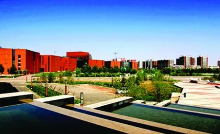
3.2Realizationof2.5DscenemodelingIn accordance with the data generated by 2.5D exhibit modeling as well as specific information, the 2.5D scene modeling generates 3D scene model, including terrain, roads, landscape, vegetation, water and other space objects. The 3D visualization of Daqing Museum is realized, as shown in Fig. 2. (i) Terrain modeling. All along, the terrain modeling is often complex and time-consuming. In modeling, it needs to consider terrain factors, and the proportional relationship between objects[4]. In this article, the surface modeling mainly uses Sketchup modeling software, to import the CAD building data of Daqing Museum into the modeling software. According to the dimension scale, the visible 3D terrain is generated, to show the terrain inside and outside the museum, as well as the distribution of each exhibition area. (ii) Building modeling. The building is an important part of scene modeling system, and the external environment of museum is complex. For the building modeling, there is a need to conduct spatial measurement or aerial photo extraction, to obtain the data about outline, height and house vertex coordinates of buildings[5]. In modeling of Daqing Museum, 3ds Max is used for the building modeling, and the building model mainly uses polygonal modeling method. Multiple circle lines are added, and the outer contour of the model is adjusted, to generate .3ds format file. (iii) Plant modeling. Plant is irregular entity, and the simulation methods of trees are generally divided into three categories: geometric entity model, wireframe model and mapping model[6]. In the past, the best tree model generating algorithm in the computer field is fractal algorithm[7]. However, the model generated using fractal algorithm requires a lot of data, the computation is complex, and the real-time 3D rendering efficiency is low, so it is rarely used in the plant modeling. In order to improve the final real-time efficiency of rendering, the 2.5D modeling method is still used for the woody vegetation. The approximate plane is first created in 3ds Max, Adobe Photoshop is used to perform the texture mapping processing on the woody vegetation photograph, and the image file is saved as a PNG format. PNG image supports Alpha transparency properties, and can show details of trees and vegetation. Since the real tree photo is used, the model effect is relatively good.

Fig.2The3DsceneoutsideDaqingMuseum
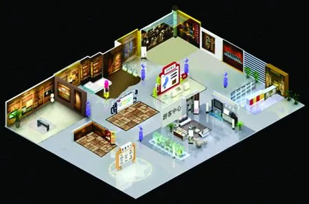
3.3RealizationofsceneinteractivecontrolThe data generated by 2.5D exhibit and scene modeling are used for interactive control operation such as roaming and navigation. The internal roaming effect of Daqing Museum is shown in Fig. 3. (i) Scene navigation. Scene navigation simulates real roaming status, and visitors can roam freely in the 3D scene, and feel free to visit Daqing Museum and the nearby area. (ii) Path roaming. The path roaming is user-defined. The roaming path, walking speed, specific exhibition area, exhibits and other parameters are pre-set so that the visitors can roam automatically according to the designed parameters. (iii) Attraction positioning. There are many exhibition areas and rich exhibits in Daqing Museum. Due to complex environment, visitors can not roam aimlessly in the scene. Therefore, the attraction can be found by positioning exhibit No. and name. (iv) Scene information release. Using Unity software, the scene generated is published in the .exe form, to complete roaming control.

Fig.3InternalroamingcontrolofDaqingMuseum
4 Conclusions
In this paper, taking Daqing Museum for example, we develop a 2.5D architectural modeling technology, and combine it with virtual reality technology, to create the virtual museum simulation platform. By establishing the virtual simulation platform of Daqing Museum, we verify the feasibility of using 2.5D architectural modeling technology to build the virtual museum system, create a virtual simulation platform with practical value. Through the platform, we can better publicize museums and other cultural industries, and provide decision support for the future planning and management of exhibition hall, in order to better promote the development of museum and other cultural industries. Through the initial operation, this platform gains good social benefits and economic benefits, which verifies the broad prospects for the development of virtual museum.
[1] LIANG F. The research on the interactive display of virtual reality virtual museum [D].Shanghai:Shanghai University,2010:33-34. (in Chinese).
[2] LIU GY, WANG N, ZHAO XY,etal. Application of virtual reality technology in the process of Chinese agricultural modernization [M].Dalian: Dongruan Electronic Press, 2015(4): 87-92. (in Chinese).
[3] CHEN YQ, LEI KB. Virtual reality technology and application [M].Beijing: Science Press,2015.(in Chinese).
[4] CHEN DX, XIA D, ZHANG Y,etal. Design of three-dimensional model of geographic information management on system campus underground pipeline network [J].Journal of Heilongjiang August First Land Reclamation University,2015,27 (4):107-109.(in Chinese).
[5] SUN M, MA GN, MAO SJ. Tree representation and visualization in 3DGIS [J]. Journal of Computer-Aided Design & Computer Graphics,2001,13(10): 901-905.(in Chinese).
[6] HAN BL, LUO QS, ZHANG H,etal. Application of 3DS MAX sticking picture and material texture and lighting function in mechatronics product virtual sculpting [J].Journal of Yanshan University,2005 (3):230-236. (in Chinese).
[7] QI DX. Fractal and its computer generation [M].Beijing: Science Press,1994.(in Chinese).
杂志排行
Asian Agricultural Research的其它文章
- Empirical Analysis on Financial Development, Urbanization, and Urban and Rural Resident Income in Jiangsu Province
- Farmer’s Perception on Supply-Demand Matching of New Variety and Its Influence Factors
- Vegetation Coverage Changes in the West Qinling Region from 2000 to 2010: A Case Study of Longnan City
- A Study of Estimation Model for the Chlorophyll Content of Wheat Leaf Based on Hyperspectral Imaging
- The Value Insistence of the Cultural Production in the Big Data Era
- Sino-Australian Agricultural Product Trade Development in the Context of the Belt and Road Initiative
