Quantity Calculation of the Land Unsuitable for Farming: A Case Study of Anze County in Shanxi Province
2016-01-12,,
, ,
1. College of Geographical Science, Shanxi Normal University, Linfen 041000, China; 2. School of Geography, The University of Melbourne, VIC 3010, Australia
1 Introduction
Arable land is the most valuable type among land resources, whose quantity and quality reflect the comprehensive grain production capacity. To protect food security, China implements strict arable land protection system, and establishes the goal of retaining 1800 million mu of arable land. For arable land protection, we should not only focus on quantity goal, but also pay attention to quality goal and ecological safety. In recent years, a lot of incidents of suffering from nature retaliation due to the over-exploitation and ecological destruction, have occurred during the land development process; meanwhile, there is arable land damage and arable land degradation due to over-exploitation. Degradation of arable land, from one side, indicates that arable land has been excessively developed. If we reclaim the ecologically fragile land, we will face more serious land degradation, ecological deterioration and other issues[1]. Second survey shows that 9.963 million ha of arable land is located in the northeastern and northwestern forests, grassland, the areas within the highest flood level control lines of rivers and lakes and steep slopes of more than 25 degrees. A considerable part of arable land needs to be gradually adjusted in accordance with the national overall plan of converting arable land to woodland, grassland, and wetland[2]. At present, China’s ecological environment is increasingly deteriorating, and ecological protection and construction has been not only related to arable land protection issues, but also related to the survival and development of the whole country[3]. Therefore, the development and utilization of arable land resources should be combined with ecological security issues, and the farming suitability evaluation criteria should also shift from lop-sided attention to natural farming suitability to giving consideration to ecological safety. Taking Shanxi’s Anze County for an example, based on ecological safety and natural suitability criteria, we establish the evaluation indicator system to evaluate the farming suitability of existing land in the county, and calculate the minimum area of arable land per capita and grain per capita after abandoning tillage, in order to combine food safety with ecological safety, and improve the ecological environment quality.
2 Overview of the study area
Anze County is a county of Shanxi, China. It is under the administration of Linfen City. Anze County is located on the Loess Plateau, and in the southeastern foot of Taiyue Mountain. It has a total area of 1960 km2, and administers 4 towns, 3 townships, 104 administrative villages and 513 natural villages. Anze, as a national ecological demonstration zone, is in Taiyue Mountain water conservation and biodiversity protection ecological function area. The main ecological function of this area is to conserve soil and water and maintain species diversity. It is the water conservation area of Qinhe River, Danhe River, Zhanghe River and Fenhe River. Anze County is in the water conservation forest area of the Taihang Mountains, with forest covering area of 1.98 million mu, forest greening rate of 67.2% and forest coverage rate of 45.44%. According to land use change survey results in 2012, the county had a total area of 1960 km2, including 241 km2of arable land (12.29%), and 995 km2of forest land (50.75%), more than half of total area in the county. It has a total population of 82012, and the per capita area of arable land is 0.29 ha, far more than the national per capita area of arable land (0.10 ha)[2], 2.9 times of the national average. The arable land is partly located on hillside with slope of greater than 25°, partly in the ecologically protected areas, and partly in the areas prone to geological disasters. This part of arable land should be ecologically reused for other purposes, to achieve ecological functions.
3 Data sources and method
3.1DatasourcesThe data for this study are from the reserve arable land resource survey and evaluation, including slope map, second land survey and change data, ecological protected areas, geological disaster point coordinates, traffic data,StatisticalYearbook,NationalEconomicandSocialDevelopmentStatisticsBulletinand the like.
3.2MethodThis paper uses the limiting factor evaluation method, that is, the farming suitability evaluation is conducted on various evaluation indicators, and as long as one of the indicators does not meet the conditions, it is not suitable for farming. Each indicator is made dimensionless. If the conditions are met, the value is 1, or else, the value is 0. The product of the indicators is used as the evaluation result of farming suitability, to evaluate the quality of arable land. It is calculated as follows:
(1)
whereAis farming suitability evaluation result;Kiis the dimensionless value of indicatori.
4 Farming suitability evaluation
4.1EvaluationindicatorsFor the farming suitability evaluation of land, we should not only consider natural suitability of land resources, but also take into account the ecological safety. Natural suitability reflects the suitability level of land resources as arable land. Ecological safety reflects the ecological tolerance of arable land development and use, to ensure that arable land is not developed and used at the cost of ecological environment[4]. Based on the evaluation indicator system in line with ecological safety and natural suitability criteria, combined with the evaluation indicators for reserve arable land resources inTechnicalProvisionsonSurveyandEvaluationofNationalReserveArableLandResources, we select 10 indicators (ecological conflicts, terrain slope, soil depth, soil texture, soil pollution, salinization level, soil pH, annual accumulated temperature, annual precipitation and irrigation conditions, and geological disasters) to evaluate the farming suitability of land resources.
Table1FarmingsuitabilityevaluationindicatorsforlandinAnzeCounty

No.EvaluationindicatorsConditionsunsuitableforfarming1EcologicalconflictsLocatedintheecologicalprotectionzone2Terrainslope>25°3SoildepthSoildepth<60cm4SoiltextureCoarseorgravellysoilorrockwithoutcroppingdegreeofgreaterthan2%5SoilpollutionSoilispolluted(heavymetalcontamination)6SalinizationlevelSeveresoilsalinization(soilsalinity>1%)7SoilpHpH≥9.5,alkalinesoil8AnnualaccumulatedtemperatureAnnualaccumulatedtemperature(≥10℃)<1800℃9AnnualprecipitationandirrigationconditionsNaturalprecipitation≤350mm,withoutirrigationconditions10GeologicaldisastersLocatedwithinthescopeofgeologicaldisasters
Table2Evaluationresultsofsomeindicatorsaffectingfarmingsuitabilityofland

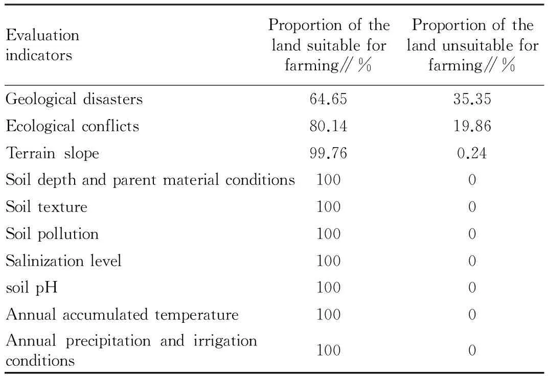
EvaluationindicatorsProportionofthelandsuitableforfarming∥%Proportionofthelandunsuitableforfarming∥%Geologicaldisasters64.6535.35Ecologicalconflicts80.1419.86Terrainslope99.760.24Soildepthandparentmaterialconditions1000Soiltexture1000Soilpollution1000Salinizationlevel1000soilpH1000Annualaccumulatedtemperature1000Annualprecipitationandirrigationconditions1000
4.2EvaluationresultsIn the evaluation indicators, soil depth and parent material conditions, soil texture, soil pollution, salinization level, soil pH, annual accumulated temperature, and annual precipitation and irrigation conditions, are assigned to 1, that is, they are not the limiting factors affecting the farming suitability of land in Anze County, and only ecological conflicts, terrain slope and geological disasters are the limiting factors.
4.2.1Geological disasters. The constraint of geological disasters means that the evaluation unit is near the geological hazard points. The main geological disasters in Anze County include landslip, landslides, mudslides and ground subsidence, and there are 196 disaster points. Taking into account the need for security and prevention of disasters, the evaluation units near geological disaster points are identified as the land unsuitable for farming. The arable land to be abandoned due to geological disaster limitations accounts for 35.35% of the evaluation object.
4.2.2Ecological conflicts. The ecological conflict restriction is due to its location in the ecological protection zone. There are five provincial-level forest parks (Mayi Temple, Mount Huanghua, Mount Qingsong, Mount Antai, Xunzi Cultural Park) and one provincial-level nature reserve (Hongni Temple) in Anze County. Based on important functions of ecological protection areas, all the evaluation objects in the ecological protection zone are identified as the land unsuitable for farming. Evaluation results show that the arable land in ecological protection areas accounts for 19.86% of the evaluation object. The arable land in ecological protection zone should be gradually abandoned for other purposes, in order to make the ecological protection zone better play its ecological functions such as water and soil conservation, and protection of species diversity.
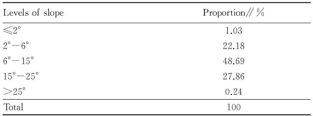
4.2.3Terrain slope.TechnicalSpecificationonLandUseSurveydivides slope of arable land into five levels: ≤2°; 2°-6°; 6°-15°; 15-25°; >25°. Different levels of slope have different effects on arable land use. For ≤2°, there is generally no soil erosion; for 2°-6°, there may be mild erosion, and it is necessary to pay attention to soil and water conservation; for 6°-15°, there may be moderate soil erosion, and it is necessary to take some measures such as terracing and contour planting to strengthen soil and water conservation; for 15°-25°, the soil erosion is serious, and it is necessary to take comprehensive engineering and biotechnology measures to control soil erosion; for >25°, wasteland reclamation is limited according to provisions ofWaterandSoilConservationLaw. Meanwhile,WaterandSoilConservationLawprovides that crop farming in the hillsides with a slope of over 25° shall be prohibited; as for the planting of economic forest in the hillsides of over 25°, we shall scientifically select tree species and reasonably determine the scale. Therefore, this paper takes the evaluation object with terrain slope of over 25° as the land unsuitable for farming. Evaluation results show that the arable land to be abandoned for other purposes due to terrain slope limitations accounts for 0.24% of the evaluation object.
Table3DistributionofarablelandwithdifferentlevelsofslopeinAnzeCounty

LevelsofslopeProportion∥%≤2°1.032°-6°22.186°-15°48.6915°-25°27.86>25°0.24Total100
4.2.4Farming suitability evaluation results. By evaluating 10 indicators, we use formula (1) to calculate the farming suitability evaluation results. 1 represents the land suitable for farming, and 0 represents the land unsuitable for farming. The area of the land suitable for farming is 12348 ha, accounting for 51.3% of the area of evaluation object; the area of the land unsuitable for farming is 11743 ha, accounting for 48.7% of the area of evaluation object.
5 Discussions
5.1TheamountofarablelandandarablelandareaafterabandoningtillageThe minimum area of arable land per capita gives the bottom line of quantity of arable land that needs to be protected in order to ensure the food safety in one region. The minimum area of arable land per capita is the function of food self-sufficiency rate, per capita food demand, and food production capacity[5-8]. The calculation model is as follows:
(2)
whereSminis the minimum area of arable land per capita (ha);ais the food self-sufficiency rate (%);xis the per capita food demand (kg);dis the grain yield (kg/ha);Sis the proportion of grain sowing area to total sowing area (%);kis the multiple cropping index (%).
According to the national target of not less than 95% inChina’sFoodIssuepublished by Information Office of the State Council in 1996, combined with the research results of Shi Peijun[9], Chen Baiming[10], Deng Dacai[11]and Ke Bingsheng[12], the food self-sufficiency rate takes 100% in accordance with the bottom line of 1800 million mu of arable land. The Chinese food safety objectives, developed by National Food and Nutrition Advisory Committee in 2004, recommend that the per capita amount of grain should be 391 kg in a basic well-off society (2010), 437 kg in a comprehensive well-off society (2020), and 472 kg in the transition period to become rich (2030). In addition, Liu Zhenwei (2004)[13]points out that when the per capita food demand is higher than 400 kg, food safety can be ensured; when the per capita food demand is 350-400 kg, food safety is in tight balance; when the per capita food demand is less than 350 kg, the food crisis will occur. Finally, the per capita food demand is set to 437 kg. According toNationalEconomicandSocialDevelopmentStatisticsBulletininAnzeCounty(2011)[14], the crop sowing area was 385860 mu, grain growing area was 357419 mu, and the annual food output was 105802 t. Based on the above data, the minimum area of arable land per capita in Anze County is calculated at 0.089 ha (1.33mu), and based on the county population of 82012, the amount of arable land is set to 7299 ha, which can ensure regional food safety. After abandoning tillage, there is still 12348 ha of arable land, much larger than the amount of arable land, so abandoning tillage can ensure food safety.
5.2Percapitaamountofgrainandfoodself-sufficiencyrateafterabandoningtillageBased on formula (2), the per capita amount of grain can be calculated at 743.12 kg. Food self-sufficiency rate can reach 170%, and the food safety can be fully ensured.
6 Conclusions
Based on 10 evaluation indicators concerning ecological safety and natural suitability criteria, we use the limiting factor evaluation method to evaluate the arable land in Anze County. Results show that Anze County needs to reuse 11743 ha of arable land for other purposes, 48.7% of the existing arable land, to ensure ecological safety; it still retains 12348 ha of arable land after abandoning tillage, 51.3% of the existing arable land, which can ensure 0.15 ha of arable land per capita, 743.12 kg of grain per capita and 170% of food self-sufficiency rate. Retaining 1800 million mu of arable land is the goal of strictly protecting arable land, while ecological construction is an urgent need for a comprehensive well-off society. When the two conflict, it is necessary to be based on the actual situation, combined with regional positioning and development strategy, to coordinate relations between the two. Based on ecological safety and natural suitability criteria, there is a need to reuse the land unsuitable for farming for ecological purpose, to ensure the ecological security. "Dynamic equilibrium of total arable land", as the core of existing arable land protection theory and index system, emphasizes "human-land balance" and mainly aims to solve the food problem, but fails to fully reflect the balance between land and environment. With the progress of science and technology and the change of natural ecological environment, it is necessary to explore new arable land protection theory and index system in accordance with local conditions to adapt to the needs for sustainable development of population, resources and ecology.
[1] ZHANG FR. Study on the evaluation indicators of the arable land from the view of ecological security [J]. China Land Science,2009,23(9):4-8,14. (in Chinese).
[2] Ministry of Land and Resources of the People’s Republic of China. The bulletin on main data results of the second national land survey [EB/OL] . http://www.mlr.gov.cn/zwgk/zytz/201312/t20131230_1298865.htm,2013-12-30.(in Chinese).
[3] Research Group of Economic Construction and Cultivated Land Protection. Ecological protection and cultivated land conservation [J].China Land Science,2001,15(3):1-4.(in Chinese).
[4] ZHANG JX, CHEN YQ, YAO YM. Study on land use regionalization based on land-use function. case study of Jilin province [J].Journal of China Agricultural University, 2008,13(3):29-35.(in Chinese).
[5] TANG J, CHEN ZG, ZHAO XF,etal. China’s farmland protection and food security: Discussion with professor Mao Yu-shi [J].China Land Science, 2009, 23(3): 4-10. (in Chinese).
[6] CAI YL, FU ZQ, DAI EF. The minimum area per capita of cultivated land and its implication for the optimization of land resource allocation [J].Acta Geographica Sinica, 2002,57(2):127-134.(in Chinese).
[7] RAN QH, YUE YH, XIE DT,etal. Calculating the threshold value of per capita arable land security in China [J]. Resources Science, 2007, 29(3):158-164.(in Chinese).
[8]DING ZW. Study on the prediction of suitable cultivated land in Xingtai City [D]. Shijiazhuang: Hebei Normal University,2010.P21-46.(in Chinese).
[9] SHI PJ, YANG MC, CHEN SM. Study on the rate level of food self-supporting and safety in China [J]. Journal of Beijing Normal University(Social Science Edition),1999(6):74-80.(in Chinese).
[10] CHEN BM, ZHOU XP. Analysis on the grain self-sufficient ratio and the safe baseline of cultivated land in China [J]. Economic Geography,2005,25(3):145-148.(in Chinese).
[11] DENG DC. Discussion on the constitution of the rate of food self-supporting and safe quantity [J].Grain Issues Research,2005(3):12-13.(in Chinese).
[12] KE BS. On the the rate of food self-supporting and grain trade issues in China [J]. Agricultural Outlook,2007,3(4):3-6.(in Chinese).
[13] LIU ZW. The Food Security Issues in China [J].Problems of Agricultural Economy, 2004, 25(12): 8-13.(in Chinese).
[14] Anze County Statistical Bureau. Statistical bulletin of national economy and social development in Anze County in 2011 [EB/OL]. http://www.anze.gov.cn/info/news/shows/4684.htm,2012-05-10. (in Chinese).
杂志排行
Asian Agricultural Research的其它文章
- Research on Compensation Mechanism of Land Acquisition in Rural Areas Based on the Practice of Anhui Province
- Methods and Paths for Rural Collectively Owned Profit-oriented Construction Land Entering into Trading Market
- Effect of Transplantation in Different Seedling Age on Growth and Yield of Spring Maize in Shanxi Early Mature Area
- Effect of Nitrogen Topdressing on Growth and Yield of Garlic
- A Study on Phosphorus Use Efficiency of Wheat
- On China’s New Urbanization and Land Use
