Connection of Farmland Consolidation Construction Works in Northern Anhui Plain: A Case Study of Si County of Anhui Province
2016-01-11,,*,
, ,*,
1. College of Economics and Management, Anhui Agricultural University, Hefei 230036, China; 2. Institute of Land and Resources, Anhui Agricultural University, Hefei 230036, China
1 Introduction
Land consolidation project is of great significance for sustainable use of land resources and sustainable development of entire social economy; it is an objective requirement for realizing sustainable development and also an inevitable path for realizing sustainable development[1]. Land consolidation planning and design are a complex systematic work and the key link in land consolidation, it directly influences investment and benefits of consolidation and is a decisive factor for implementing consolidation task and objective and realizing reasonable land use[2]. According to practical experience and theoretical requirements, land consolidation planning and design include four works: (i) land leveling, (ii) irrigation and drainage, (iii) field road works, (iv) farmland protection and ecological environment protection works. These four works complement each other, and are interdependent. Planning and design personnel should take full consideration of all factors and make reasonable judgment and decision. Through project implementation, it is expected to realize square field, network-like forest, connected roads, irrigable, connected channels, and drainable field.
2 Existing problems in farmland consolidation
2.1InternalconnectionoflandconsolidationprojectAs a complex and systematic project, land consolidation not only involves terrain, landform, soil, hydrological and climatic conditions, water resources, irrigation canals and ditches, roads, land use type and habits, social conditions and economic development level, but also involve many other factors such as river system, roads, terrain, and distribution of towns. Terrain and landform in the project area influence or even determine decisions of design of land parcel, ditches, and roads; hydrological and climatic conditions, water resources, social condition, and economic development level affect or even determine design of land use pattern, ditches and roads; roads, river system, and terrain outside the project area influence design of main roads and ditches; distribution of towns influences land use design within the project area, and there are many interdependent factors. Therefore, it is required to take land consolidation as a system, take overall consideration of these factors, attach importance to connection of four works, to realize mutual integration of land use system and environment and avoid occurrence of unfavorable conditions[3].
2.2Existingproblems
2.2.1Land consolidation can be simply understood as land leveling. Some areas blindly pursue image of land consolidation and require realizing the objective of "square field, network-like forest, connected roads, irrigable, connected channels, and drainable field" regardless of natural conditions. As a result, land leveling works take up more than half land consolidation costs. Anthropogenic mellowed soil cultivated by farmers through several decades or even a hundred year is buried underground and can not be turned over permanently.
2.2.2Ditches and channels straightened. Ditches and channels are crooked and can store large volume of water, and can provide habitat for wild animals and plants. However, in the current land consolidation concept and practice, many areas straighten ditches and channels. In consequence, wild animals and plants suffer a huge impact due to not adapting to survival environment[4].
2.2.3Not reasonable design of field roads. In some land consolidation projects, field roads fail to match with land parcels, ditches and channels, and forest, which is not favorable for field management, and not well connected with outside roads, so it fails to form unified rural road network[5]. What's worse, it fails to suit measures to local situations, select local materials, take full advantage of original field roads, and fail to reasonably connect with field facilities, leading to covering large area[2].
2.2.4Little attention to farmland protection and ecological environment protection. Land consolidation is not a short-term combination, adjustment, transformation or increase of farmland area, but should be oriented towards long-term landscape protection and ecological balance. At present, some land consolidation projects excessively stress high grade design and lay concrete roads and ditches in fields. This not only blocks natural breath of soil, influences changes of micro-environment temperature, but also disturbs living and rest of small animals and plants. Besides, hardening of ditches and channels may also lead to many problems, such as high flow velocity and smooth surface are harmful to spawning and breeding of planktonic organisms and fishes; surrounding areas of hardened ditches and channels lack plants, so there will be direct sunlight and high difference of day and night temperature, not favorable for ecological development; hardening is adverse to living and breeding of aquatic organisms, and self-purification functions of aquatic organisms to pesticide pollution[4]. More concrete roads and ditches means less green fields and less habitats, so excessive cement and concrete will inevitably harm ecological balance[6].
3 Case study of Si County
3.1GeneralsituationsoftheprojectareaThe project area is situated in Liuwei Town and Shantou Town of Si County, Suzhou City of Anhui Province, involving Xima Village and Gaodu Village in Liuwei Town and Tongcheng Village, Shantou Village, and Luomiao Village in Shantou Town. The total area of land consolidation was 2095.24 hm2. Excluding large area forest area, residential area, rivers, and independent industrial and mining areas, the total construction area was 1896.10 hm2.
(i) Natural conditions. The project area is situated in Huaibei Plain, the terrain is high in the northwest and slightly low in southeast, the terrain is relatively flat with average altitude of 17 meters. Soil type is fluvo-aquic soil, the soil layer is deep, and soil texture is homogeneous. Surface water is supply mainly by natural precipitation and guest water, underground water resource is rich, and natural water quality is high and unpolluted, suitable for irrigation and drinking by people and animals. The project area belongs to temperate semi-humid and semi-arid monsoon climate with distinct four seasons. The vegetation is mainly deciduous broad-leaved forest. Due to damage of cultivation, natural vegetation basically disappears and is gradually replaced by artificial vegetation.
(ii) Social economic conditions. The project area is about 20 km from Si County. Surrounded by county and town level roads, the project area has excellent traffic conditions. According to statistics, agricultural population of the project area is 12754, agricultural production history is long, and it has certain foundation, the industrial production is weak, and there is no scale economy. Township economy is mainly agricultural economy, but intensive and mechanized production level is low. For a long time, raising agricultural economic benefit, increasing farmers' income and improving people's living conditions are top priorities of local government.
(iii) Current situations of land use. Current land use situation adopts the survey data of 2008: the total construction area was 1896.10 hm2including agricultural land 1887.60 hm2accounting for 99.55% of total construction scale; the construction land area was 1.60 hm2, accounting for 0.08%; other land area was 6.90 hm2, accounting for 0.36% of total construction scale.
Table1Currentlanduseoftheprojectarea
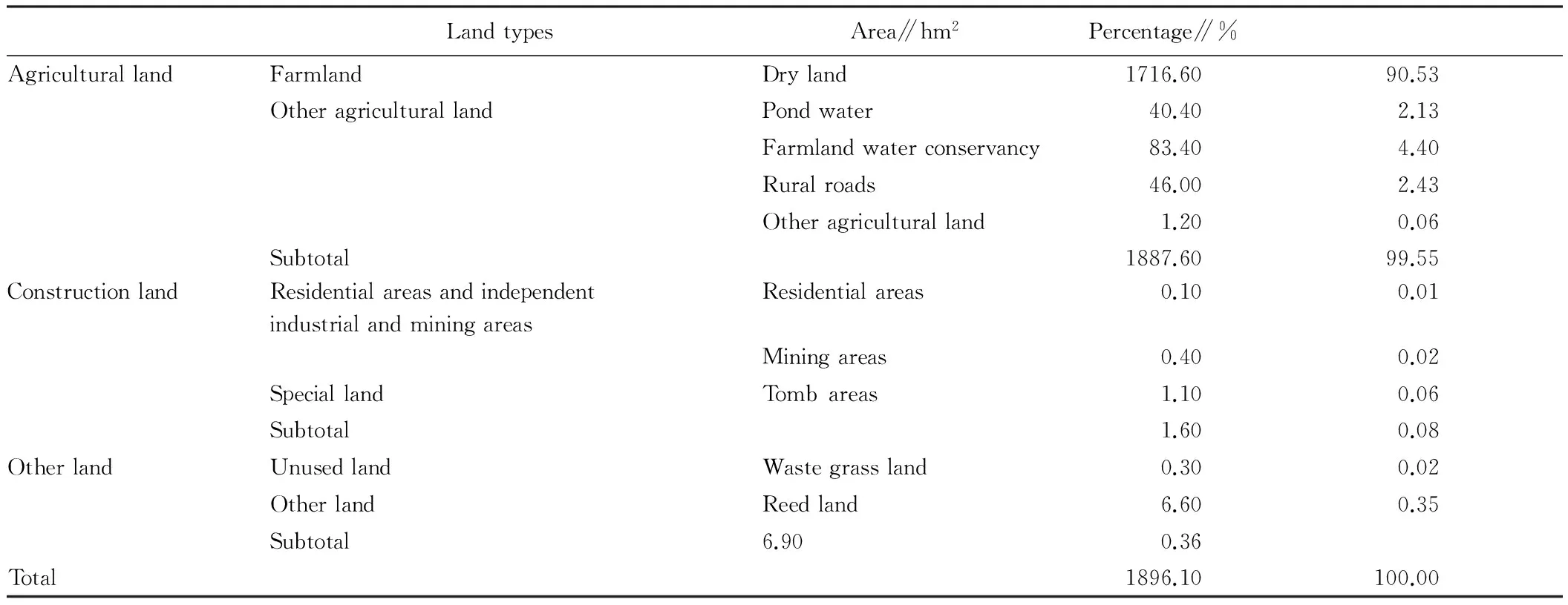
LandtypesArea∥hm2Percentage∥%AgriculturallandFarmlandDryland1716.6090.53OtheragriculturallandPondwater40.402.13Farmlandwaterconservancy83.404.40Ruralroads46.002.43Otheragriculturalland1.200.06Subtotal1887.6099.55ConstructionlandResidentialareasandindependentindustrialandminingareasResidentialareas0.100.01Miningareas0.400.02SpeciallandTombareas1.100.06Subtotal1.600.08OtherlandUnusedlandWastegrassland0.300.02OtherlandReedland6.600.35Subtotal6.900.36Total1896.10100.00
Data source: land development and reclamation center of Si County
3.2ExistingproblemsoflanduseinprojectareaThe farmland area in the project area takes up a big portion, construction land is relatively little, scattered ponds and residential area are much, field roads and ditches and channels take up large area, there is little forest protection land and unused land, so the land consolidation condition is excellent and the potential is high. The main existing problems are as follows: (i) Low land use efficiency. The farmland area in the project area is large but the quality is low. Before consolidation, the farmland area was 1716.60 hm2, accounting for 90.53% of construction scale. Due to influence of natural conditions, middle-and-low-yielding fields take up a larger portion. In addition to extensive operation and management, ditches and channels are not matched and are vulnerable to droughts and floods, so the agricultural yield is relatively low. (ii) Poor infrastructure. Water conservancy facilities are poor and the drought-resistance is weak; field roads are crooked and distribution is not reasonable, the traffic to outside is not smooth. (iii) Waste ditches and channels occupy a larger area, and the blockage is serious. It not only impedes agricultural production, but also wastes land resources. (iv) Field parcels are varied in area, not favorable for mechanized operation.
3.3LeadingconstructionofworksintheprojectareawithplanninganddesignAccording to characteristics of terrain and landform, land consolidation can be divided into water and soil conservation type agricultural and forest combined consolidation mode in low mountain area, water-saving type ecological modified consolidation mode in plain area, and water saving and water and soil conservation combined consolidation mode in hilly area[7]. Si County is situated in Huaibei Plain area and rich in water resources. Besides, the terrain is flat. Land use is mainly agricultural land. Natural disasters mainly include drought, flood, and sandstorm. Therefore, land consolidation in this area should focus on strengthening farmland water conservancy facility improvement, land parcel regulation, and farmland protection forest construction.
3.3.1Land leveling works.
(i) Field arrangement. Consolidated fields should be favorable for growth of crops, mechanized operation, and water and soil conservation, and should satisfy irrigation and drainage and wind prevention requirements. Besides, they should be convenient for operation and management. Farming fields adopt strip and grid design: 300-600 m long and 80-300 m wide strip fields; 60-120 mm long and 20-40 m wide grid fields. The arable layer thickness is not less than 20 cm. When leveling the land, to protect topsoil of arable layer in the project area, we peeled the topsoil[8]. Firstly, shovel the topsoil to specially arranged storage area, and conduct leveling using deep barren soil. Then, fill back arable layer topsoil to the storage area, the thickness is not less than 20 cm. The specific design of topsoil peeling: to protect soil of arable layer, push the soil of 20 cm thick arable layer to one side before arrangement, and restore the soil layer after completion of leveling. For arable land with high terrain, firstly peel mellowed topsoil, and fill back topsoil after land leveling; for low-lying arable land, also firstly peel topsoil, then fill back topsoil when it reaches the designed height. According to soil texture and arable layer depth, the peeling of topsoil should be 20 cm, and the planned peeling is 40000 m3. The calculation formula is as follows:
Vtopsoil=Speeling area×0.2
(Formula 1)
In calculation, for fields with excavation backfill depth less than 30 cm, topsoil peeling is not necessary.
(ii) Division and method of land leveling. The terrain of the project area is relatively flat. The field slope is basically consistent, so it is not necessary to make leveling and division. Attention should be paid to fields with high height difference and inconvenient irrigation and drainage. Such fields and low-lying fields, waste ditches and channels should be moderately leveled, considering reasonable distribution of earthwork and balance of excavation and backfill. It is required to take full use of current land use situations and realize internal earthwork balance as much as possible.
(iii) Earthwork calculation.
The project area belongs to plain area. Except some large ditches and channels and some low-lying lands in central area, most parts are relatively flat. According to current situations of the project and terrain and landform, it should build a horizontal strip field with certain slope. The earthwork calculation adopts weighted average method. Take any field (with area of S) as an example, the specific method is as follows: Firstly, draw up the designed height Hdesign. Hdesignis determined according to arranged ditch and channel flow direction on the basis of balancing the excavation and backfill of earthwork as much as possible. Hdesign needs several times of assumption to ditch and channel arrangement and the excavated and backfilled earthwork. Within the range of the area of this field (generally 0.1-3 mu), take points representing different heights of the field, set n height points (H1, H2, H3,…Hn, expressed in m). In the n height points, the points higher than Hdesignare excavation and points lower than Hdesignare backfill. For the difference between each point and Hdesign, negative value is backfill depth, and the positive value is excavation depth, and the algebraic sum is 0, to ensure balance of excavation and backfill.
i) Calculation of average excavation depth:
Hexcavation= ∑Hexcavation/ L-Hdesign
(Formula 2)
where ∑Hexcavationdenotes the height sum of height points higher than Hdesign.
L is the number of height points higher than Hdesign.
ii) Calculation of average backfill depth:
Hbackfill= Hdesign-∑Hbackfill/M
(Formula 3)
where ∑Hbackfilldenotes the height sum of height points lower than Hdesign.
M is the number of height points lower than Hdesign.
iii) Calculation of excavation and backfill area:
Sbackfill= S×nbackfill/n
(Formula 4)
Sexcavation=S×nexcavation/n
(Formula 5)
where nbackfilldenotes number of height points lower than Hdesignin the field.
nexcavationdenotes number of height points higher than Hdesignin the field.
iv) Calculation of excavation volume:
Vexcavation= Sexcavation× Hexcavation
(Formula 6)
Vbackfill= Sbackfill× Hbackfill
(Formula 7)
Separately substitute values of corresponding height points to Formula 6 and Formula 7, we obtained that leveling of the field needs excavation of 120000 m3earthwork and backfill of 120000 m3earthwork. In sum, the excavation and backfill reached balance by the above method. It took full consideration of terrain and division of fields, consistent with realities of the project area.
(iv) Typical field design. Typical fields were designed according to terrain conditions, planting structure and farming habits of the project area. Some fields adopt natural boundary as field limit according to actual terrain. And fields can be adjusted properly according to actual situations.
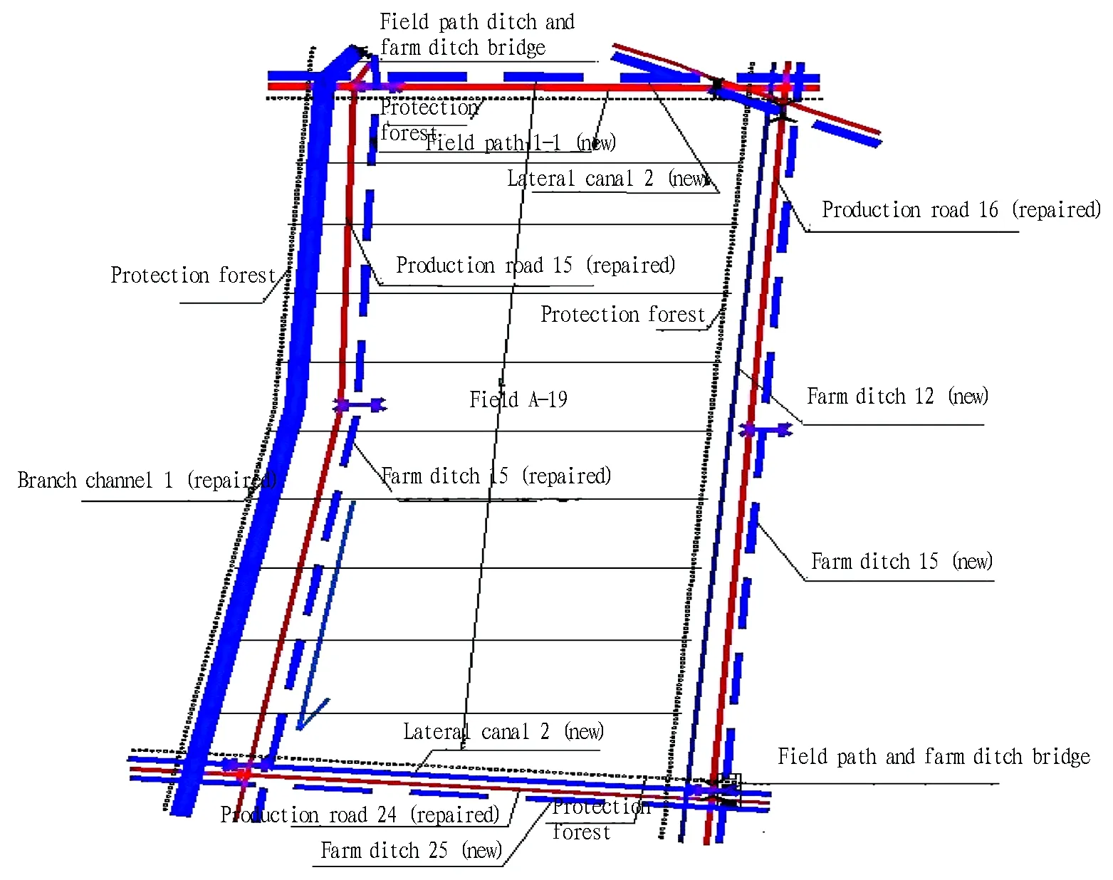
Fig.1 Design drawing of field A-19
3.3.2Farmland water conservancy projects.
(i) Irrigation works
i) Pump station. There is an old hydropower station in Shantou floodgate of new Tonghe river. This power station has been abandoned for many years. In our survey, we found that at the water intake of original pump station, the water flow is stable, favorable for flood, pollution and sand prevention. Thus, it is feasible to select the site in original place. Therefore, we recommend building a new pump station in the original site, to intake water directly from new Tonghe River, ensure 1.9 million m3irrigation water and satisfy irrigation demands of 668.37 hm2farmland. Banks of the river are steep, so the bank type arrangement was adopted and the front edge of intake building slightly protrudes to banks. The entire irrigation area covers more than 10000 mu, adopts 2 vertical axial-flow pumps with flowrate of 55 kw 0.6 (1.2 m3water can be delivered if running simultaneously). According to pump type, electrical equipment, inlet and outlet water requirements, we designed a main pump house and distribution room separately. The design level of inlet tank adopted average daily or quarterly water level 14.75 m that can guarantee 85%-95% water source, and the design level of outlet tank was 17.95 m.
ii) Pit-pond. Pit-pond is mainly used for storing surface run-off and supporting channel and well irrigation. Because soil in the project area is loose, in addition to out of repair for long years, the pit-pond is seriously blocked and has low water storage capacity. In this project, we proposed repairing and excavating the pit-pond, and the excavated earthwork will be used for reclamation of pit-pond and ditch.
iii) Motor-pumped well.
In normal years, the daily water output of a single well in 15 hours is 30-40 m3, the maximum irrigation demand of crops is 40 m3/mu, irrigation period is 8 days, and irrigation water utilization coefficient adopts 0.75, then the controlled area of a single well is:
F = ηQtT/M
(Formula 8)
where F: irrigation area of a single well, expressed in mu; η: irrigation water utilization coefficient, take 0.75; Q: available flowrate, m3/h, take 35m3/h; T: daily supply hours of water, take 14 h/d; T: designed irrigation period, take 8 days; M: designed volume of irrigation, take 40 m3/mu.
Through calculation, F = 73.5 mu. Since there is 88 m3surface run-off in one mu project area stored in pit-pond, we designed on the principle of one well controlling 80 mu, then the project area needs 167 wells with depth of 40 m. In the well irrigation area, each well is equipped with mobile pump and delivery hose, and the mobile pump also can be used for water intake from pit-pond.
iv) Channels. In field A, we proposed building a branch channel with 2184 m length, 4 m wide upper outlet, 1 m wide lower outlet, 1.5 m depth, wall thickness 8 cm, C15 concrete reinforced, 5 cm thick concrete and mortar cushion, side slope 1∶1, design flowrate 1.22 m3/s, longitudinal slope ratio 1/5000, 0.2 m wide in channel bank; 4 ditches with length of 6872 m, 3 m wide upper outlet, 0.6 m wide lower outlet, 1.2 m depth, wall thickness 6 cm, C15 concrete reinforced, 4 cm thick concrete and mortar cushion, side slope 1∶1, design flowrate 0.55 m3/s, longitudinal slope ratio 1/3000, 0.2 m wide in channel bank; 47 canals with length of 18821 m, 1.7 m wide upper outlet, 0.5 m wide lower outlet, 0.8 m depth, wall thickness 4 cm, C15 concrete reinforced, 2 cm thick concrete and mortar cushion, side slope 1∶0.75, design flowrate 0.26 m3/s, longitudinal slope ratio 1/2000, 0.2 m wide in channel bank. The planned irrigation channel has a total length of 27877 m and covers an area of 6.13 hm2.
(ii) Water drainage works
In this project, we designed the drainage modulus as per the occurrence rate of rainstorm every 5 years,i.e. 1.05 m3/s/km2.
i) Design of drainage ditch. The section size of drainage ditch was designed taking the typical field as an example, and the section size of ditch took the new ditch 1 as an example. The detailed calculation process includes following two steps.
a. Calculation of drainage ditch flowrate. Except the field water drainage, the project area should also consider domestic water of residential area nearby and surface run-off in areas with higher terrain. According to provisions ofCodeforDesignofIrrigationandDrainageEngineering(GB50288-99), the drainage criterion adopted the occurrence rate of rainstorm every 10 years, and the rainstorm duration and drainage time adopted 1 day rainstorm and 1 day drainage to water depth of submergence tolerance of crop[9].
The specific calculation formula of ditch flowrate is as follows:
(Formula 9)
Irrigated field:R=P-hfield storage-E
Dry land:R=aP
where Q is designed drainage flowrate of ditch, m3/s; R is designed runoff depth, mm; q is designed drainage modulus, m3/s·km2; F is controlled area of ditch, km2; t is drainage time (d), take 1 day in this project; a is runoff coefficient; P is designed rainstorm, mm; h field storage is depth of field storage, mm, take 40 mm; E is evaluation of paddy field during the t period.
b. Design of ditch section size.
The hydraulic calculation formula for ditch section size:
(Formula 10)
where Q is designed flowrate of ditch, m3/s; A is area of cross section, m2; V is average flow velocity of cross section, m/s; R is hydraulic radius, R = A/X, X is wetted perimeter, m; C is Chezy coefficient, calculated using formulaC=n-1R1/6,nis bed roughness (take 0.025); i is the ditch slope (take 1/2000). There are 175 drainage ditches in the project area, including 14 ditches with a total length of 31636 m and 161 farm ditches with a total length of 66115 m, and trapezoidal section with concrete was adopted and the side slope is 1∶1.
ii) Occupation size and reclamation design of drainage ditches
a. Occupation size
Currently, the ditches occupy 43.53 hm2, and after consolidation, they will occupy 36.39 hm2. New ditches occupy 14.74 hm2and repaired ditches cover 21.65 hm2.
b. Earthwork source
The new ditches cover 14.74 hm2, and it plans to reclaim 35.7 hm2waste ditches, needing 222000 m3earthwork, including 60000 m3earthwork from excavating channels and 176400 m3earthwork from ditch desilting.
iii) Ditch desilting
Original ditches and farm ditches in the project area were desilted. In land consolidation project, original ditches and channels should be used as much as possible to reduce workload. In this project, 6 ditches were desilted with the length of 19182 m, opening width 5 m, bottom width 1 m, current depth 0.5 m, and designed depth 2 m, and slope coefficient 1∶1, and the desilted earthwork was 71900 m3; 71 farm ditches were desilted with the length of 40198 m, opening width 3 m, bottom width 1 m, current depth 0.4 m, designed depth 1 m, and slope coefficient 1∶1, and the desilted earthwork was 104500 m3; in sum, it can provide 176400 m3earthwork through desilting ditches. Earthwork can be used for hydraulic structure reclamation, landfill of waste ditches and channels, and paving road bed.
iv) Excavation of drainage ditches
Since original ditches in the project area are naturally formed, most of them are crooked and occupy a large area, the excavation is mainly undertaken for ditches and farm ditches. Apart from desilting and dredging original ditches, it is required to excavate new drainage ditches. In the project area, the total length of ditches is 31636 m, new ditches have a total length of 12454 m, as per opening width 5.6 m, bottom width 1.1 m, depth 1.5 m, 8 cm thick C15 concrete placed, 5 cm cement mortar cushion, designed flowrate 1.87 m3/s, the longitudinal slope ratio 1/3000, and excavating 62600 m3as per slope coefficient 1∶1.5; the total length of new farm ditches is25917 m, as per opening width 3 m, bottom width 1 m, depth 1 m, designed flowrate 0.62 m3/s, the longitudinal slope ratio 1/2000, and excavating 51800 m3as per slope coefficient 1∶1; therefore, total earthwork excavation of drainage ditches = excavation of ditches + excavation of farm ditches = 62600 m3+ 51800 m3= 114400 m3. Since roads and ditches are distributed with ditches and roads adjacent to each other, the earthwork excavation adopts excavation and use at the same time, the excavated earthwork will be use for paving the road bed.
3.2.3Road works.
(i) Design of field path. According to requirements ofLandDevelopmentProjectPlanningandDesignStandards(TD/T1012-2000), combining actual situations of the project area, the criteria for field path are as follows: road width 6 m, road bed 8 m, road shoulder 1 m, 0.7 m higher than ground surface, 20 cm plain soil compacted, 25 cm Telford base, 25 cm thick C30 cement concrete pavement, slope 1∶1.5; criteria for field path I: road width 4 m, road bed 5 m, road shoulder 0.75 m, 0.3-0.5 m higher than the ground surface, 10 cm plain soil compacted, 20 cm thick 10% lime soil base, 20 cm C30 cement concrete pavement, slope 1∶1.5; criteria for field path II: road width 4 m, road bed 5 m, road shoulder 0.75 m, 0.3-0.5 m higher than the ground surface, 12 cm plain soil compacted, 20 cm thick 10% Telford base, 15 cm clay-bound macadam, 3 cm graded sand surface, and slope 1∶1.5. In the project area, a total of 11869 m field path and 20829 m field road was arranged[10].
(ii) Design of production road. The project planed to build 146 production roads with a total length of 64862 m, road width 3 m, road bed 4 m, road shoulder 0.5 m, 0.3 m higher than the ground surface, along the original ground surface, 15 cm thick 8% lime base, 15 cm thick clay-bound macadam, and slope 1∶1.5.
3.2.4Farmland protection works. To prevent sandstorm, the project area planned to plant protection forest in field paths, field roads (repaired and new), to protect ditches, roads and improve ecological environment. Besides, 2 rows of suitable trees were planted along field paths and field roads, forming a total length of forest network 130801 m, with row spacing of 3 m, and 43600 trees were planted in total[8].
4 Recommendations on the basis of practice in Si County
4.1LandlevelingworksLand leveling in Huaibei Plain area should focus on keeping and transformation of land fertility. (i) Planning and implementation of land leveling project should be coordinated with other works in land consolidation. When formulating land leveling scheme, it is required to take overall consideration of irrigation, drainage, field roads, farmland protection and ecological and environment conservation works, to make them connect with each other. It is recommended to conduct land leveling in combination with actual situations of the project area, closely connect with field, ditch, channel and road works, reduce excavation and backfill of earthwork as much as possible, and reduce unnecessary mechanical consumption leading to waste due to rework[11]. (ii) It is recommended to properly increase workload of surface soil stripping, and change surface soil stripping 20 cm to stripping according to thickness of arable layer. The arable layer of fields in different place is varied. Before surface soil stripping, it is required to inspect section of arable layer and determine the surface soil stripping thickness according to inspection results, to avoid waste of mellowed soil. (iii) Strengthening soil modification measures. Field combination and reducing bumpy-ridge coefficient in the land leveling process are process of modifying soil, and it is able to judge whether soil structure reaches soil requirements of arable layer. For too sandy or sticky soil, it is recommended to modify soil through mixing sandy soil and clay; acid soil can be modified through lime and gypsum. In addition, it is recommended to encourage farmers in the project area to plant green manure crops and use farm manure, return straws to fields, and conduct rice field-upland field rotation, increase soil organic content, and improve soil fertility and farming fertility level, so as to lay solid foundation for building high standard capital farmland[12].
4.2IrrigationanddrainageworksWater conversancy projects such as rivers and canals should follow the natural terrain, keep original longitudinal winding and horizontal diverse form, and build multi-level and multi-functional water supply and drainage system. Also, it is recommended to simulate natural river ecological system, and establish water course ecological restoration and natural revetment, to improve self-restoration and biodiversity protection function of water body[13].
(i) Rivers and canals should keep original terrain and landscape as much as possible, to avoid straightening bends, and should keep original habitat environment. (ii) Channels with high velocity should increase water retention facilities, to slow down water flow and alleviate impact on ecology. (iii) It is recommended to design channels with unsmooth surface, to realize varied water flow, full perturbation of water flow, stabilize water temperature, and provide diversified bottom habitat environment, and keep survival of organisms at channel bottom[4].
4.3FieldroadworksField roads, bridges and culverts should avoid influencing hydrologic conditions, water flow characteristics, and arrange ecological bridges and ecological paths, to reduce impact on natural conditions; arrange buffer zone to reduce disturbance to residential areas, vegetation, soil, and water quality along the roads, bridges and culverts[13]. (i) If condition permits, roads should be designed firstly. As artery of rural life and production, field road network system once established will form close connection with fields, channels and ditches, and protection forest. This will be easier to realize the purpose of connecting four works, make them more coordinated, and bring into play optimal function of land consolidation. (ii) Rural road construction should suit local conditions and select local materials. Materials should mainly use stones, and road shoulders can provide survival places for wild plants and animals. (iii) It is recommended to arrange channels and ditches along roads and carry out green belt and buffer zone construction.
4.4FarmlandprotectionandecologicalenvironmentprotectionworksFarmland protection forest construction should attach great importance to restoration of natural vegetation, increase green corridors and separate plots, bushes, simulate regional natural plant communities, take full advantage of local plants, and establish ecological economical landscape protection forest system[13]. (i) Natural materials should be used in construction, to manifest local unique landscape, combine with rural scene, and create natural beauty of environment. (ii) Low-lying areas may be established as ecological protection zone. Low-lying area is commonly called swamp or marsh. Although with barren productivity, low-lying area is excellent habitat for wild plants and animals. Thus, it can be designed as ecological protection zone, planting forage grass or aquatic plants, realizing sustainable ecological environment. (iii) It is recommended to survey and cultivate indigenous species. Since it is easier to restore indigenous species, it is required to carry out detailed survey, screening and cultivation, to benefit ecological protection of the project area[4].
[1] WANG WM. Land consolidation and sustainable development[J]. Land & Resources,2003(3):19-23. (in Chinese).
[2] JIANG J. Studies on planning and design of rural land arrangement project[D].Changsha:Hu’nan Agricultural University,2010. (in Chinese).
[3] CHEN ZJ. Study on the planning and design of land consolidation project[D].Beijing:China Agricultural University,2005. (in Chinese).
[4] LIU R.On the arrangement of the land and the view of scientific development[J].Journal of Anhui Agricultural University(Philosophy & Social Sciences Edition),2004,13(6):14-17. (in Chinese).
[5] NIU CJ. Analysis on the optimization of the design project of land consolidation project[D].Beijing: Beijing Forestry University, 2007. (in Chinese).
[6] YU ZX. Study on land consolidation based on theory of ecology and landscape science[J]. Journal of Huazhong Agricultural University(Social Sciences Edition),2007(6):87-91. (in Chinese).
[7] ZHANG TX. A preliminary exploration on land consolidation mode[J].Land and Resources Information,2009(10):20-21. (in Chinese).
[8] Department of Land and Resources of Anhui Province. Standards of land development and consolidation project construction, DB/T001-2008[S]. Hefei:Department of Land and Resources of Anhui Province, 2009,1. (in Chinese).
[9] Ministry of Housing and Urban-Rural Development of the People’s Republic of China. Specification of irrigation and drainage engineering design, GB50288-99[S].Beijing: The Ministry of Water Resources of the People’s Republic of China,1999,3. (in Chinese).
[10] Ministry of Land and Resources of the People’s Republic of China. Specification of land development and consolidation project planning and design, TD/T1012-2000[S]. Beijing:Ministry of Land and Resources of the People’s Republic of China,2000,10. (in Chinese).
[11] CHEN D. Discussion the land levelling issues in the land consolidation[J].Modern Agricultural Sciences and Technology,2012(5):385-387. (in Chinese).
[12] WEI A. On the maintaining of farmland productivity in the process of land levelling[J]. Fujian Agricultural Science and Technology,2011(3):72-74. (in Chinese).
[13] XU G. Analyzing the approaches and design of ecological land renovation projects[J].Shanghai Land & Resource, 2012,33(1):51-54. (in Chinese).
杂志排行
Asian Agricultural Research的其它文章
- Research Progress in Tomato Responses to Abiotic Stress
- Current Situations and Recommendations for Non-grain Tendency of Farmland in Anhui Province
- A Study on the Reform and Further Development of "Chongzhou Mode" Based on the Perspective of Modern Enterprise Management
- Spatiotemporal Coupling of Water and Fertilizer for Double-cropping Grape in Guangxi
- On the Government Function Orientation in China’s Agricultural Management Reform
- Empirical Study on Satisfaction of Farmers with Land Requisition in Guangdong Province