四川岷江上游滑坡触发因素分析
2015-07-01李艳豪蒋汉朝徐红艳梁莲姬
李艳豪 蒋汉朝* 徐红艳 梁莲姬
(中国地震局地质研究所, 地震动力学国家重点实验室, 北京 100029)
四川岷江上游滑坡触发因素分析
李艳豪 蒋汉朝* 徐红艳 梁莲姬
(中国地震局地质研究所, 地震动力学国家重点实验室, 北京 100029)
以高山峡谷为地貌特征的岷江上游地区人口密集, 在晚更新世以来发生了数以万计的滑坡, 探讨该地区滑坡发生的主要触发因素对该地区的地质灾害防治意义重大。文中从区域降雨特点、 滑坡坡形特点、 地震震级大小与滑坡面积的对应关系以及叠溪已恢复地震记录的周期性分析等方面入手展开探索性研究。在降雨方面, 与滑坡灾害严重的尼泊尔相比, 岷江上游无论是累积降雨量还是日降雨量均未达到触发滑坡的关键阈值。在坡形方面, 岷江上游的滑坡不具有暴雨触发滑坡形成的坡底峡谷地形特征, 而具有地震触发滑坡形成的自上而下较为平坦的坡面特征。在震级大小与滑坡面积的对应关系中, 岷江上游的大面积滑坡分布支持地震触发, 与暴雨触发的局部小面积滑坡形成鲜明对比。在叠溪已恢复地震记录的周期分析中, 我们获得能够导致该地区软沉积物变形的>5.0或5.5级地震的复发周期集中于二三十年, 而引发大面积滑坡的可能类似汶川特大地震的平均复发间隔为2.6ka。这与中等—特大地震以及滑坡面积随地震震级一般呈现指数增长关系相吻合。据此, 我们初步认为, 岷江上游地区晚更新世以来发育的大量滑坡由降雨触发的可能性很小, 绝大部分可能为地震触发。这一初步认识有待今后的细致研究进一步验证。
四川岷江上游 滑坡成因 地震 暴雨 滑坡坡形 复发间隔
0 引言
滑坡是指斜坡上的土体或者岩体, 受河流冲刷、 地下水活动、 雨水浸泡、 地震及人工切坡等因素影响, 在重力作用下, 沿着一定的软弱面或软弱带, 整体或部分顺坡向下滑动的自然现象。据相关统计, 滑坡每年在全球范围内造成数十亿美元的经济损失(Spikeretal., 2003)。大多数滑坡沿剪切面发生, 受摩擦强度减弱触发(Lambeetal., 1969)。已有研究显示, 引起剪切面摩擦强度减弱的最常见因素是暴雨(Trauthetal., 2000, 2003; Gabetetal., 2004; Bookhagenetal., 2005)和地震活动(Keefer, 1984, 1999; Jibsonetal., 1993; Malamudetal., 2004; Dadsonetal., 2004; Owenetal., 2008; Hewittetal., 2011; Xuetal., 2014a)。 Schulz等(2009)研究认为, 大气潮汐也会调整剪切面摩擦强度进而引起滑坡运动。
有效识别1个地区滑坡发生的主要因素需要从这个地区的具体条件(滑坡的时空分布规律、 区域构造背景、 气候及地形地貌特点等)入手展开工作(Cozieretal., 1995; 黄润秋, 2004, 2007; 李晓等, 2008)。最近, 青藏高原东部地区发生了以汶川8.0级特大地震为代表的严重自然灾害, 引起广大科研工作者的关注。在震后科考中, 殷跃平(2008)、 Yin等(2009)、 Dai等(2011)和Xu等(2012, 2014a)等发现汶川地震之后岷江上游地区滑坡面积和滑坡数量有较为明显的增加, 可能是岷江上游大面积滑坡的主要触发因素。另一方面, 考虑到该地区位于青藏高原东缘, 属于亚热带—暖温带, 受西南季风影响, 降雨主要集中于夏季。这为暴雨引起岷江上游地区发生大规模滑坡提供了可能(李媛等, 2004; 常晓军等, 2007)。这样, 岷江上游地区触发滑坡的主要因素到底是降雨还是地震, 成为当前迫切需要解决的科学问题。这对滑坡发生严重的岷江上游地区自然灾害防治工程设计与规划影响深远。
1 研究区地质背景
岷江是长江上游左岸的一级支流, 发源于四川与甘肃交界的岷山南麓。岷江上游是指都江堰以上河段及其支流, 处于青藏高原东缘至四川盆地的过渡带, 长约340km。该地区的地貌类型以高山峡谷为特征。河谷深切, 最大相对高差达3000m(Wangetal., 2011)。河谷两侧的谷坡陡峭, 平均坡度为30°~35°(葛永刚等, 2009; 张斌等, 2011)。区域内出露的地层主要有志留系茂县群的千枚岩、 绢云石英片岩和碳酸盐岩, 白龙江群的板岩、 千枚岩和灰岩等; 泥盆系危关群的绢云千枚岩、 石英千枚岩、 板岩和石灰岩等; 石炭系雪宝顶群的灰岩及千枚岩, 西沟群的灰岩; 二叠系的千枚岩和灰岩; 三叠系菠茨沟组的板岩、 变质砂岩及灰岩, 杂谷脑组的变质砂岩和灰岩, 侏倭组的变质石英砂岩与千枚岩不等厚互层、 新都桥组的千枚岩和板岩, 罗空松组的变质砂岩和板岩以及第四系多种成因的松散沉积物。其中, 志留系和三叠系发育相对完整, 以千枚岩分布较为广泛为特征。第四系因高山峡谷地形地貌和长期剥蚀仅零星分布。受岷江断裂带、 虎牙断裂和龙门山逆冲推覆带的影响(Chenetal., 1994; Zhangetal., 2010; Wangetal., 2011)。该地区褶皱和断裂较为发育, 部分地层如千枚岩等较为破碎, 易于风化和被水软化。较低的岩石强度, 结合显著的高山峡谷地形地貌和全年降雨多集中于夏季的特征, 导致崩塌滑坡等表生地质灾害颇为严重。据不完全统计, 2008年之前, 岷江上游地区的滑坡有300多处, 其中岷江主干流汶川—较场段滑坡最为密集, 规模最大的是汶川县岷江左岸的周仓坪滑坡, 滑坡体的体积达3×10⁷m3, 滑坡崩塌的总体积达到数亿m3(乔建平, 1994; 孟晖等, 2004)。
2 岷江上游滑坡成因探讨
基于岷江上游严重的滑坡灾害, 本次研究拟从区域降雨特点、 滑坡坡形特点、 诱发该地区滑坡发生的震级以及已发表的晚更新世地震记录周期特征与近期地震复发间隔的对比等方面展开分析, 以期为该地区滑坡发生诱因的厘定提供有效制约。
2.1 岷江上游降雨引起滑坡的可能性
针对1个具体地区而言, 降雨能否触发滑坡, 需要对该地区的降雨特点开展详细而具体的分析, 如降雨区域、 降雨量、 降雨强度、 降雨历时、 研究区地质地貌条件等(Finlayetal., 1997; 钟荫乾, 1998; Daietal., 2001; 林孝松, 2001; 林孝松等, 2001; Gabetetal., 2004; 谢剑明等, 2004; 魏丽等, 2006)。谢剑明等(2004)研究浙江非台风区和台风区滑坡稳定性时发现, 触发滑坡发生的降雨阈值明显不同: 在非台风区, 当日降水量达到60mm和130mm, 有效降水量达到150mm和225mm时, 滑坡高易发区和中易发区的滑坡点密度明显增加; 而在台风区, 日降雨量分别达到90mm和150mm, 有效降雨量分别达到125mm和275mm时, 滑坡高易发区和中易发区的滑坡点密度明显增加。Brand等(1984)详细分析了1963—1983年的香港滑坡数量与1~30d的累积降雨关系之后, 认为香港绝大部分滑坡由历时短的强降雨诱发, 把小时降雨量75mm作为灾难性滑坡的临界降雨量, 并进一步提出可利用24h 累积降水量预测滑坡的发生。当24h降雨量<100mm时, 滑坡发生的可能性很小; 当24h降雨量>200mm时, 严重的滑坡灾害发生的可能性很大。杨顺泉(2002)研究湖南省滑坡灾害时提出, 发生滑坡的降水临界值为日降雨量≥120mm, 小时降水量≥40mm。除了降雨量, 林孝松(2001)和李晓(1995)强调滑坡发生区域的地质地貌条件也应该引起重视, 如重庆市北岸区缪云山及相邻地区植被相对较好, 引起地质灾害的临界降雨强度为150mm/d; 而重庆市南岸区真武山一带植被相对较差时, 产生地质灾害的临界降雨强度为100mm/d(李晓, 1995)。可见, 降雨引起滑坡多发生在降雨量大且比较集中的华东—华中地区, 尽管引发滑坡的短时强降雨阈值在不同地区差别明显, 但累积有效降雨量一般要超过100mm。

图1 青藏高原东缘地区降雨量Fig. 1 Rainfall in the eastern margin of the Tibetan plateau.蓝色(坐标横轴之上)表示每月日平均降雨量(mm); 紫色(坐标横轴之下)表示月平均降雨量(mm); P降雨量
值得注意的是, 这些研究地区的区域特点与岷江上游相比, 无论是降雨分布还是地形地貌特点都相差较大。不过, 令人兴奋的是, Gabet等(2004)对尼泊尔的安纳布尔纳山脉的Khudi Khola流域开展了降雨与滑坡的关联性研究。该地区与岷江上游地区分属青藏高原南缘和东缘, 同受西南季风影响。在坡度方面, Khudi Khola流域的地形坡度主要为20°~35°, 平均坡度为26°±8°。而岷江上游地区的平均坡度为30°~35°, 两个地区均发育较多的陡坡, 坡度分布较为一致。在地形地貌方面, Khudi Khola流域的海拔高度为600~5100m, 平均海拔为2565m(Gabetetal., 2004), 属于高山峡谷地形。岷江上游地区同属高山峡谷地形, 海拔高度900~5000m左右, 平均海拔3000m左右, 两地区都主要为中高山地貌。在岩性方面, Khudi Khola流域出露的基岩多为片岩和片麻岩, 与岷江上游地区类似, 均属强度低、 易被水渗透软化的岩石类型。青藏高原活动的整体性和连贯性为我们研究岷江上游降雨与滑坡之间的关联性找到了与该地区(尼泊尔Khudi Khola流域)的可对比性。Gabet等(2004)利用2000—2002年间的日输沙量和日降雨量详细对比分析了Khudi Khola流域季风降雨与滑坡之间的关系, 得出降雨引发滑坡的2个关键阈值——累积季风降雨量需要达到860mm, 同时日降雨量需要达到11mm。相比之下, 岷江上游以松潘和红原为代表的1970—2000年降雨数据(图1)显示, 年平均降雨量(MAP)分别只有721.9mm和767.3mm, 夏季(6—9月)的累积平均降雨量(MCP)分别为414.3mm和492.3mm, 最高降雨月的日平均降雨量(MMDP)分别只有4mm和4.5mm。它们均未达到尼泊尔降雨-滑坡关系的累积季风降雨阈值。值得注意的是, 茂县年平均降雨量只有490.7mm(Jiangetal., 2014), 推测夏季MCP与松潘和红原相比更低。不仅如此, 我们也对松潘和红原附近的青藏高原东缘其他地区进行了分析, 如阿坝(MAP为727mm, MCP为510mm, MMDP为4.5mm)、 马尔康(MAP为781.4mm, MCP为515.3mm, MMDP为5.1mm)、 道孚(MAP为617.4mm, MCP为460.3mm, MMDP为4.3mm)、 小金(MAP为616.3mm, MCP为398.8mm, MMDP为4.3mm)和甘孜(MAP为662.1mm, MCP为457.4mm, MMDP为4.4mm)。值得注意的是, 即使在岷江上游的下限都江堰地区, 其MAP为1173mm, MCP为821mm, MMDP为8.5mm/d, 也未达到尼泊尔降雨-滑坡关系研究得出的累积季风降雨阈值。鉴于日平均降雨量不能代表具体某一天的降雨量, 我们仔细检查核对了岷江上游地区中国地面国际交换站各气象站点的降雨数据, 发现岷江上游地区的日降雨量绝大部分都低于11mm/d。这表明岷江上游地区不仅年平均降雨量达不到860mm(图2), 季风期日降雨量达到11mm/d的可能性也很小, 由此推测暴雨引发滑坡的可能性也很小。

图2 岷江上游区域年降水量等值线图Fig. 2 Annual precipitation isograms of the upper reaches of the Minjiang River.数据来源: 中国地面国际交换站《气候资料年值数据集》中所有岷江上游地区1951—2009年间的降水量数据

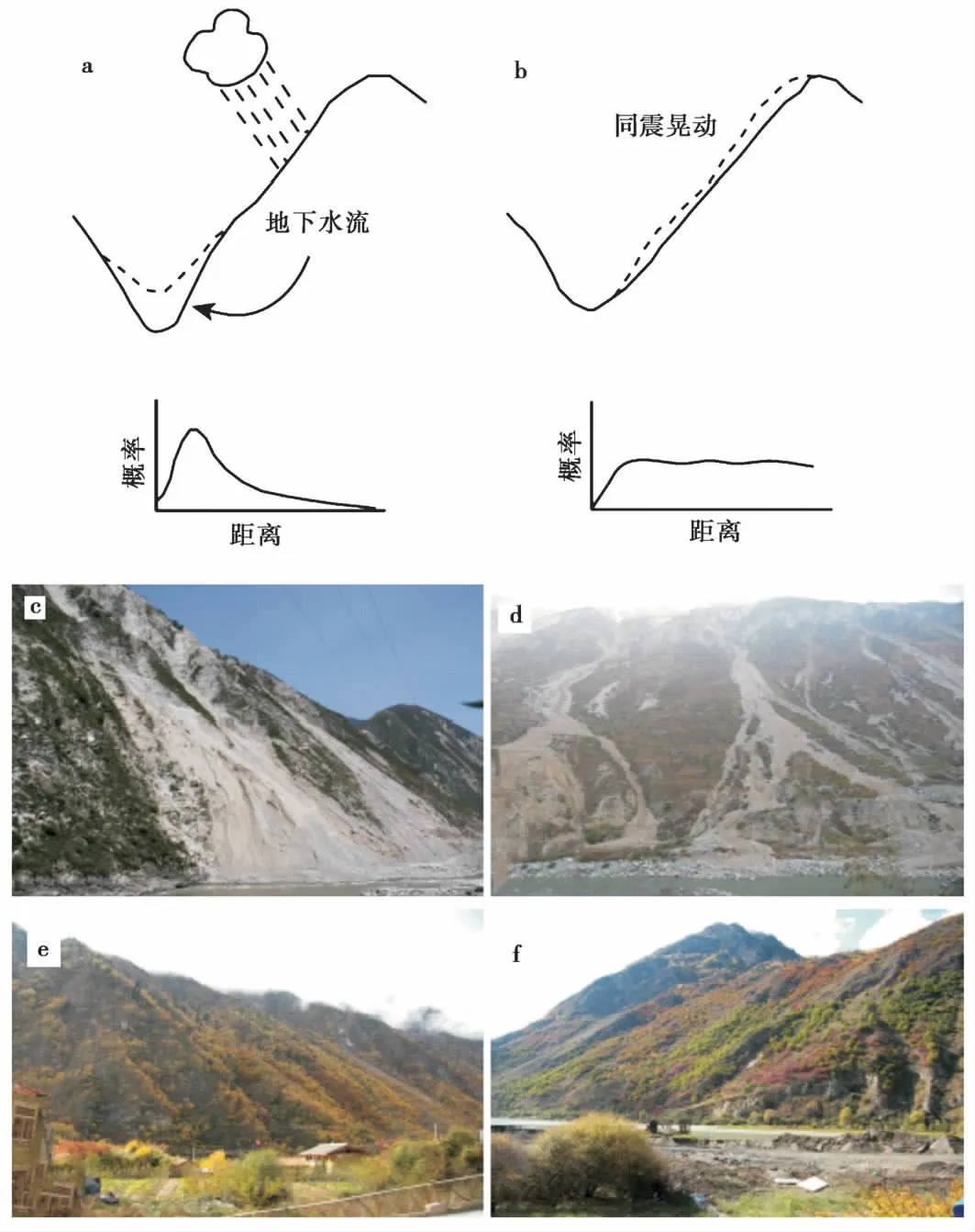
图3 滑坡发生坡面横截面的概念模型图(a, b;Densmore et al., 2000)与岷江上游滑坡(c—f)Fig. 3 Hypothetical hillslope cross sections showing(a) storm and(b) earthquake triggered bedrock landslides(Densmore et al., 2000); (c-f)Representative photos showing landslides in the study area.a 暴雨诱发的滑坡形态; b 地震诱发的滑坡形态; 虚线表示滑坡前地形, 实线表示滑坡后地形, 同时还给出了从坡底到坡顶发生滑坡的概率分布推测
2.2 岷江上游滑坡形态特征
山地地形侵蚀通常通过山坡风化剥蚀和山谷下切实现(Burbanketal., 1996)。暴雨和地震能够优先影响山地地形不同部位的演化(Iversonetal., 1992; Bouchonetal., 1996)。不管是暴雨还是地震, 它们长期作用于山坡的证据可能被该山坡地形很好地锁定和保存。
Iverson 等(1992)研究发现, 接近饱和状态的山坡的渗透压力会引起有效应力的显著改变。渗透压力的空间梯度增加了山坡物质的整体应力, 因而导致了滑坡的形成。滑坡潜力在渗透压力接近饱和的山坡坡脚位置比其他地方高很多, 因为那里存在向上和向外的渗透压力。暴雨引起的山坡渗透压力接近饱和, 也确实引起了大量滑坡, 且主要聚集在坡脚位置(Megahanetal., 1978)。因为滑坡的幅度普遍遵循幂律分布(Hoviusetal., 1997), 最频繁的滑坡规模常常较小, 风化剥蚀碎屑产物仅在坡脚被带走。这种作用形成的明显较陡的坡脚只会在偶尔发生的大型滑坡作用下被破坏(Densmoreetal., 1997)。因此, 暴雨触发的滑坡地形至少应该有一些明显较陡的坡脚(Densmoreetal., 2000; 图3a), 被称为内峡谷(inner gorges)(Kelsey, 1988)。
另一方面, 地震发生时, 垂直方向的地震波被地表地形衍射传播, 造成地面加速破坏, 这种效果向山顶山脊方向被显著放大(Davisetal., 1973; Celebi, 1987; Gelietal., 1988; Bouchonetal., 1996)。这在2008年汶川地震后的野外科考中被证实(殷跃平, 2008)。中强地震发生时, 聚集山顶或山脊的滑坡会引起山顶和山脊的优先侵蚀。值得注意的是, 地震引起的地面加速破坏无处不在, 从坡顶到坡脚, 常常形成较为一致的侵蚀平面, 而缺少明显的峡谷地形(Densmoreetal., 2000; 图3b)。
针对暴雨和地震引起山坡地形侵蚀产生显著不同的山坡外貌特征, 我们观察了岷江上游不同位置的山坡坡面特征, 如图3c—f。无论是侵蚀刚刚发生不久的坡面, 还是地质时期接受侵蚀而现在被植被覆盖、 表现相对稳定的坡面, 都具有较为一致的特征——自上而下显示相对较平坦的侵蚀面, 可能反映当时自坡顶至坡脚经历了近乎一致的破坏和侵蚀。这种特征符合图3b呈现的地震作用的特征(Densmoreetal., 2000)。因此, 我们认为, 岷江上游高山峡谷地形呈现的颇为一致的面状坡形, 缺少与暴雨作用有关的峡谷地形特征(Densmoreetal., 2000; 图2a), 支持研究区大多数滑坡长期受地震触发的认识。
2.3 岷江上游滑坡的空间分布支持地震触发
降雨型滑坡和地震型滑坡虽同属滑坡, 但由于触发营力的不同, 两者在区域的空间分布上有显著差别。由降雨触发的滑坡通常以土质物质为主, 主要发生于具有滑动面的土层与岩层接触面或岩性对比反差大的成层岩质与基岩的接触面, 以小范围分布于暴雨区和久雨区为特征, 受降雨地区和降雨时间的严格控制(钟荫乾, 1998; Daietal., 2001)。相比之下, 由地震触发的滑坡的分布通常与地震参数(震级、 烈度、 震源深度、 发震断裂和震中距等)和斜坡环境参数(坡度、 坡向以及地层岩性等)密切相关(Keefer, 1984, 1994, 2002; Malamudetal., 2004; Yinetal., 2009; Xuetal., 2014b)。值得注意的是, 由强震触发的滑坡不仅发生在松散和强度较低的地层中, 在硬岩和较硬岩石地层中也有发育; 并且在高山峡谷地形地貌条件下常常呈现大范围集群分布的现象。最近的研究表明, 岷江上游的滑坡多沿断裂分布, 不完全统计显示仅汶川—茂汶段岸坡就集中了80%的崩塌滑坡(乔建平, 1994; 孟晖等, 2004)。在硬岩、 较硬岩石区域, 崩塌滑坡也有广泛分布, 并且在岷江上游由崩塌滑坡堵塞河道形成的堰塞湖成串分布(聂高众等, 2004; 杨文光等, 2008; Wangetal., 2011; 王兰生等, 2012; Xuetal., 2015)。
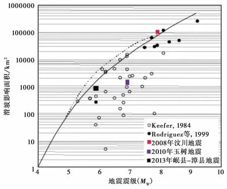
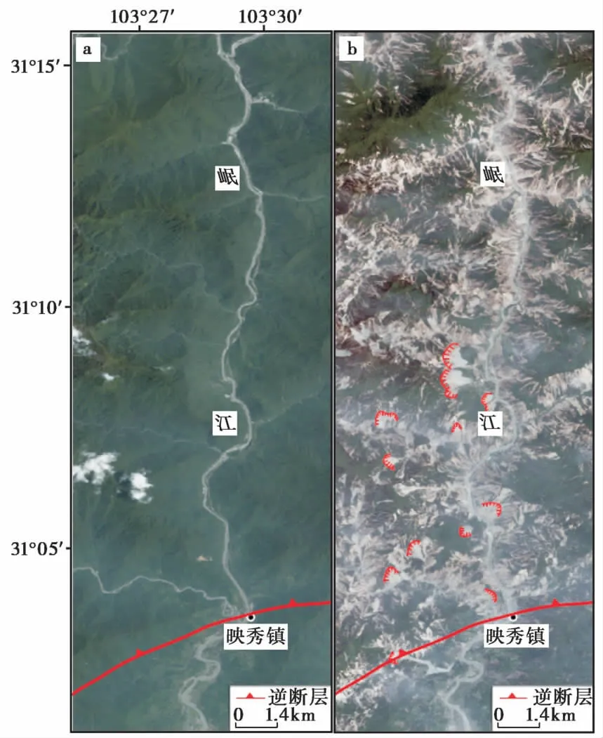
Keefer(1984)较早利用1911—1980年间全球范围内40次地震滑坡的资料对滑坡与地震参数的定量关系进行了研究, 给出了地震诱发滑坡的最小震级为4.0, 并绘制了地震滑坡影响面积与地震震级的统计曲线(图4)。后来, Rodríguez等(1999)又对其进行了补充和完善。总的来说, 滑坡随地震震级的增大而增加。尤其是在高山峡谷地区, 1次大地震可以诱发数以万计的滑坡。岷江上游强震频繁, 据史料记载, 公元638—2002年间该区M≥4.7 地震就有52次, 其中M≥7.0地震3次, 而2002年至今又发生多次地震, 尤其是2008年的8.0级汶川地震和2013年的7.0级芦山地震, 对该区滑坡的发育和分布特征影响甚广。在图4 中, 汶川地震滑坡的影响面积略高于其他震例, 也表明该区极易发生地震滑坡的特点。这与震后科考统计分析发现的汶川地震产生的高密度滑坡沿震区延伸约240km(Ouimet, 2010)、 总数目达197481个、 总面积达1160km2(许冲, 2012)相吻合。这在2008年汶川地震前后的滑坡遥感影像对比中十分明显(图5)。同时对其中的巨型滑坡进行了初步解译。

图4 滑坡影响区面积与地震震级的关系(Xu et al., 2014)Fig. 4 Relationship between area of landslide-affected zone and earthquake magnitude(after Xu et al., 2014).

图5 滑坡密集分布区岷江流域汶川地震前后QuickBird遥感影像对比 Fig. 5 QuickBird images showing the pre- and post-Wenchuan earthquake comparison of the landslide concentration area along the Minjiang River.短曲线指示研究区巨型滑坡分布; a采集日期为2005年6月26日; b采集日期为2008年6月3日
2.4 岷江上游晚更新世以来地震周期与近期地震复发间隔初步对比
地震周期最早由Reid(1911)在对1906年旧金山大地震的地震断层进行研究时提出, 它是指断层面用来恢复前一次地震所释放应变的时间。Wallace(1970)利用断层平均滑动速率与同震位移的关系估计了圣安德列斯断裂的地震重复间隔, 开创了利用断裂活动历史的资料预测未来大地震发生时间的先例。20世纪70年代以后, 随着第四纪测年技术的发展, 可以利用地层样品年代控制探槽中多次地震事件的年代进而得到地震复发间隔。目前, 对晚更新世以来地震周期的研究主要是利用活动构造参数(单次和多次地震的同震位移量、 断裂的累积位移量和滑动速率)、 古地震探槽事件的精细定年和历史地震资料(Xuetal., 1996; 闻学泽, 1998; 张培震等, 2003; 冉勇康等, 2008; Ranetal., 2010, 2013)。相比之下, 从沉积记录中提取古地震信息建立古地震事件发生的时间序列, 进而探讨区域古地震周期的研究较少。河湖相沉积物的高分辨率粒度记录常常含有丰富的物源信息(Jiangetal., 2010a, b)。最近, Jiang等(2014)对四川岷江上游叠溪出露的末次冰消期湖相沉积物开展详细的物源研究(稀土元素、 粒度和石英颗粒扫描电镜), 证明该湖相沉积物主要为风力搬运。其中, >16μm的组分可能为近源粉尘沉积, 与研究区地震触发的大面积滑坡提供大量粉尘物源有关, 因而>16μm的组分可以用来揭示该地区的地震事件。

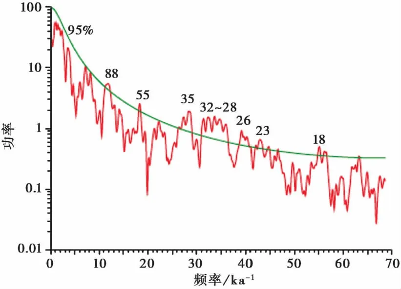
图6 岷江上游叠溪新磨村湖相沉积剖面>16μm粒组频谱分析结果Fig. 6 Spectral results of the grain-size fraction of >16μm from the Xinmocun section in the Diexi Lake,the upper reaches of the Minjiang River.抛物线表示95%的置信度水平, 频谱图上标注的数字为周期值(单位: a)
本次研究我们运用redfit 3.8频谱分析软件(Schulzetal., 2002)对叠溪新磨村湖相沉积剖面中>16μm的组分进行了地震活动周期分析, 时间跨度为18.65~10.63ka。在95%置信度之上的周期有88a、 55a、 35a、 32~28a、 26a、 23a和18a(图6)。值得注意的是, 岷江上游1933年在叠溪发生7.5级大地震、 1976年松潘发生7.2级大地震和2008年汶川发生8.0级大地震, 其复发间隔为三四十年, 接近于我们周期分析结果中的32~28a周期群。尽管该周期分析粗颗粒粉尘组分的变化与滑坡紧密相关, 而滑坡可能不完全是地震触发, 但是如前文所述, 岷江上游的滑坡主要还是地震触发。基于这一点, 我们推测, 岷江上游高山峡谷地区触发滑坡的地震震级要求可能不太高。这一推测与已有研究揭示的触发软沉积物变形的震级>5或5.5(Leeder, 1987; Ken-toretal., 2001; Moneckeetal., 2004)相吻合。另一方面, 我们观察该剖面高分辨率粒度记录时发现, 近源风成粉尘粒度组分(>16μm)持续时间较长的有3次。它们分别在17.83~17.5ka BP、 15.17~14.79ka BP和12.63~12.14ka BP, 对应持续时间分别为330a、 380a和490a, 复发间隔为2.66ka和2.54ka, 平均2.60ka。这与过去研究得出的青藏高原大震复发间隔约为2000a(Xuetal., 1996; Ouimet, 2010)或2000~3000a(Dengetal., 1996)较为一致。与此同时, 1个简单的地震震级-频率法研究给出了7级地震的发生次数通常达到8级的10倍, 6级地震发生次数通常达到8级的100倍(Ouimet, 2010)。这与我们给出的研究区中等震级(>5或5.5)发生周期为几十年而类似汶川地震的大震发生周期为2 000多年的认识也较为一致, 与地震触发滑坡面积随震级呈指数增长的认识(Keefer, 1984; Rodríguezetal., 1999)也颇为一致。
3 讨论与结论
地球内外动力地质作用、 地形地貌条件及气象条件等因素的相互耦合是群发性地质灾害发生的主要原因(Scheidegger, 1998; Flageolletetal., 1999; 王思敬, 2002; 张永双等, 2009)。针对一个具体的灾害发生地区, 从该地区的具体条件入手分析灾害发生的主要诱因对今后的灾害防治意义重大。龙门山地区, 在不到100km的距离内海拔由约500m(四川盆地)急剧增加到4000m以上(青藏高原东缘)的地形特点和2008年发生的8.0级汶川地震, 吸引了众多科研人员对该地区展开研究。殷跃平(2008)对震后地质灾害及隐患进行了系统分析, 提出地震触发了15000多处滑坡、 崩塌和泥石流。后来, 黄润秋等(2009)统计提出汶川地震触发的崩塌滑坡数量约为3.5万处, 分布面积约为1×10⁵km2。Dai等(2011)在震后利用遥感影像进行解释得出地震触发的滑坡超过56000个, 总面积达811km2。Parker 等(2011)对汶川地震滑坡统计的数量为73367, 滑坡面积565.8km2。最近, 汶川地震滑坡的编录成果显示, 地震触发了197481处滑坡, 滑坡面积约为1160km2, 大致分布在面积约1.1×10⁵km2的区域内(许冲, 2012)。可能由于排查范围及当时可用遥感数据的局限性, 这些统计数据不尽相同, 但都表明汶川地震滑坡数量多、 密度大、 分布广, 具有群集性发育的特点, 与研究区地质构造背景和高山峡谷地形地貌密切相关。
黄润秋(2007)对中国大型滑坡机制的研究结果表明, 中国大陆大型滑坡发育最根本的原因是具有有利的地形地貌条件, 约80%的大型滑坡发生在环青藏高原东侧的大陆地形第1个坡降带范围内。对岷江上游而言, 除了高山峡谷地形地貌条件, 不同地质时代的岩石强度低而易碎可能也是滑坡发生的重要地质条件。有了这些重要的条件组合, 最重要的还是主要触发因素——频发的地震活动。只有详细客观地了解地震沿断层活动的位置、 规律、 强度及已经造成的危害, 才能在今后的灾害防治工作中采取有针对性的细致工作。鉴于此, 岷江上游晚更新世以来的地震活动记录还需要进一步开展细致深入的研究, 为更好地了解该地区的地震活动性提供基础数据。
致谢 在本文撰写过程中与许冲副研究员、 袁仁茂副研究员、 何宏林研究员、 郑文俊研究员进行了深入细致的讨论, 受益匪浅, 在此深表感谢!中国地震局兰州地震研究所谢虹博士提供了详细的降雨数据, 在此一并致谢。最后, 感谢本刊主编和审稿人提出的宝贵意见和建议, 使本文得到进一步提升。
常晓军, 丁俊, 魏伦武, 等. 2007. 岷江上游地质灾害发育分布规律初探 [J]. 沉积与特提斯地质, 27(1): 103—108.
CHANG Xiao-jun, DING Jun, WEI Lun-wu,etal. 2007. Distribution of the geological hazards in the upper reaches of the Minjiang River, Sichuan [J]. Sedimentary Geology and Tethyan Geology, 27(1): 103—108(in Chinese).
葛永刚, 庄建琦. 2009. 5·12 汶川地震对岷江上游河道的影响: 以都江堰—汶川河段为例 [J]. 地质科技情报, 28(2): 23—28.
GE Yong-gang, ZHUANG Jian-qi. 2009. River channel change of the upper reaches of Minjiang River by 5.12 Wenchuan earthquake: A case study of the section of Dujiangyan-Wenchuan [J]. Geological Science and Technology Information, 28(2): 23—28(in Chinese).
黄润秋. 2004. 中国西部地区典型岩质滑坡机理研究 [J]. 地球科学进展, 19(3): 443— 450.
HUANG Run-qiu. 2004. Mechanism of large-scale landslides in Western China [J]. Advance in Earth Sciences, 19(3): 443— 450(in Chinese).
黄润秋. 2007. 20世纪以来中国的大型滑坡及其发生机制 [J]. 岩石力学与工程学报, 26(3): 433— 454.
HUANG Run-qiu. 2007. Large-scale landslides and their sliding mechanisms in China since the 20thcentury [J]. Chinese Journal of Rock Mechanics and Engineering, 26(3): 433— 454(in Chinese).
黄润秋, 李为乐. 2009. 汶川地震触发崩塌滑坡数量及其密度特征分析 [J]. 地质灾害与环境保护, 20(3): 1—7.
HUANG Run-qiu, LI Wei-le. 2009. Analysis on the number and density of landslides triggered by the 2008 Wenchuan earthquake, China [J]. Journal of Geological Hazards and Environment Preservation, 20(3): 1—7(in Chinese).
李晓. 1995. 重庆地区的强降雨过程与地质灾害的相关分析 [J]. 中国地质灾害与防治学报, 6(3): 39— 42.
LI Xiao. 1995. Relative analysis between strong rainfall process and geological hazards in Chongqing City [J]. The Chinese Journal of Geological Hazard and Control, 6(3): 39— 42(in Chinese).
李晓, 李守定, 陈剑, 等. 2008. 地质灾害形成的内外动力耦合作用机制 [J]. 岩石力学与工程学报, 27(9): 1792—1806.
LI Xiao, LI Shou-ding, CHEN Jian,etal. 2008. Coupling effect mechanism of endogenic and exogenic geological processes of geological hazards evolution [J]. Chinese Journal of Rock Mechanics and Engineering, 27(9): 1792—1806(in Chinese).
李媛, 孟晖, 董颖, 等. 2004. 中国地质灾害类型及其特征: 基于全国县市地质灾害调查成果分析 [J]. 中国地质灾害与防治学报, 15(2): 29—34.
LI Yuan, MENG Hui, DONG Ying,etal. 2004. Main types and characteristics of geo-hazard in China: Based on the results of geo-hazard survey in 290 counties [J]. The Chinese Journal of Geological Hazard and Control, 15(2): 29—34(in Chinese).
林孝松. 2001. 滑坡与降雨研究 [J]. 地质灾害与环境保护, 12(3): 1—7.
LIN Xiao-song. 2001. The study of landslide related to rainfall [J]. Journal of Geological Hazards and Environment Preservation, 12(3): 1—7(in Chinese).
林孝松, 郭跃. 2001. 滑坡与降雨的耦合关系研究 [J]. 灾害学, 16(2): 87—92.
LIN Xiao-song, Guo Yue. 2001. A study on coupling relation between landslide and rainfall [J]. Journal of Catastrophology, 16(2): 87—92(in Chinese).
孟晖, 张岳桥, 杨农. 2004. 青藏高原东缘中段地质灾害空间分布特征分析 [J]. 中国地质, 31(2): 218—224.
MENG Hui, ZHANG Yue-qiao, YANG Nong. 2004. Analysis of the spatial distribution of geohazards along the middle segment of the eastern margin of the Qinghai-Tibet Plateau [J]. Geology in China, 31(2): 218—224(in Chinese).
聂高众, 高建国, 邓砚. 2004. 地震诱发的堰塞湖初步研究 [J]. 第四纪研究, 24(3): 293—301.
NIE Gao-zhong, GAO Jian-guo, DENG Yan. 2004. Preliminary study on earthquake-induced dammed lake [J]. Quaternary Sciences, 24(3): 293—301(in Chinese).
乔建平. 1994. 岷江上游崩塌滑坡分布规律研究 [J]. 长江流域资源与环境, 3(4): 365—370.
QIAO Jian-ping. 1994. Study on the regularities governing the density distribution of collapses and landslides on the upper Mingjiang River Basin [J]. Resources and Environment in the Yangtze Valley, 3(4): 365—370(in Chinese).
冉勇康, 陈立春, 陈桂华, 等. 2008. 汶川MS8.0 地震发震断裂大地震原地重复现象初析 [J]. 地震地质, 30(3): 630— 643.
RAN Yong-kang, CHEN Li-chun, CHEN Gui-hua,etal. 2008. Primary analyses of in-situ recurrence of large earthquake along seismogenic fault of theMS8.0 Wenchuan earthquake [J]. Seismology and Geology, 30(3): 630— 643(in Chinese).
王兰生, 王小群, 许向宁, 等. 2012. 岷江叠溪古堰塞湖的研究意义 [J]. 第四纪研究, 32(5): 998—1010.
WANG Lan-sheng, WANG Xiao-qun, XU Xiang-ning,etal. 2012. Significances of studying the Diexi paleo-dammed lake at the upper stream of Minjiang River, Sichuan, China [J]. Quaternary Sciences, 32(5): 998—1010(in Chinese).
王思敬. 2002. 地球内外动力耦合作用与重大地质灾害的成因初探 [J]. 工程地质学报, 10(2): 115—117.
WANG Si-jing. 2002. Coupling of earth’s endogenic and exogenic geological processes and origins on serious geological disasters [J]. Journal of Engineering Geology, 10(2): 115—117(in Chinese).
魏丽, 郑有飞, 单九生. 2006. 暴雨型滑坡灾害预报预警方法研究评述 [J]. 气象, 31(10): 3— 6.
WEI Li, ZHENG You-fei, SHAN Jiu-sheng. 2006. Review on prediction and warning methods of landslide hazard triggered by heavy rainfall [J]. Meteorological Monthly, 31(10): 3— 6(in Chinese).
闻学泽. 1998. 时间相依的活动断裂分段地震危险性评估及其问题 [J]. 科学通报, 43(14): 1457—1466.
WEN Xue-ze. 1998. Assessment of time dependent seismic hazards on segments of active fault and its problems [J]. Chinese Science Bulletin, 43(14): 1457—1466(in Chinese).
谢剑明, 刘礼领, 殷坤龙, 等. 2004. 浙江省滑坡灾害预警预报的降雨阀值研究 [J]. 地质科技情报, 22(4): 101—105.
XIE Jian-ming, LIU Li-ling, YIN Kun-long,etal. 2004. Study of the threshold values of rainfall of landslides hazards for early-warning and prediction in Zhejiang Province [J]. Geological Science and Technology Information, 22(4): 101—105(in Chinese).
许冲. 2012. 汶川地震滑坡详细编录及其与全球其他地震滑坡事件对比 [J]. 科技导报, 30(25): 18—26.
XU Chong. 2012. Detailed inventory of the 2008 Wenchuan earthquake triggered landslides and its comparison with global other earthquake events [J]. Science & Technology Review, 30(25): 18—26(in Chinese).
杨顺泉. 2002. 突发性地质灾害防灾预警系统方案研究 [J]. 中国地质灾害与防治学报, 13(2): 109—111.
YANG Shun-quan. 2002. Research on abrupt geological hazard prevention and prediction program [J]. The Chinese Journal of Geological Hazard and Control, 13(2): 109—111(in Chinese).
杨文光, 朱利东, 郑洪波, 等. 2008. 岷江上游第四纪叠溪古堰塞湖的演化 [J]. 地质通报, 27(5): 605— 610.
YANG Wen-guang, ZHU Li-dong, ZHENG Hong-bo,etal. 2008. Evolution of a dammed paleolake in the Quaternary Diexi Basin in the upper reaches of the Mingjiang River, Sichuan, China [J]. Geological Bulletin of China, 27(5): 605— 610(in Chinese).
殷跃平. 2008. 汶川八级地震地质灾害研究 [J]. 工程地质学报, 16(4): 433— 444.
Yin Yue-ping. 2008. Researches on the geo-hazards triggered by Wenchuan earthquake, Sichuan [J]. Journal of Engineering Geology, 16(4): 433— 444(in Chinese).
张斌, 王萍, 王建存. 2011. 岷江上游堰塞湖沉积中软沉积物变形构造成因讨论 [J]. 地震研究, 34(1): 67—74.
ZHANG Bin, WANG Ping, WANG Jian-cun. 2011. Discussion of the origin of the soft-sediment deformation structures in paleo-dammed lake sediments in the upper reaches of the Minjiang River [J]. Journal of Seismological Research, 34(1): 67—74(in Chinese).
张培震, 闵伟, 邓起东, 等. 2003. 海原活动断裂带的古地震与强震复发规律 [J]. 中国科学(D辑), 33(8): 705—713.
ZHANG Pei-zhen, MIN Wei, DENG Qi-dong,etal. 2003. Paleoearthquake rupture behavior and recurrence of great earthquakes along the Haiyuan Fault, northwestern China [J]. Science in China(Ser D), 48(38): 364—375.
张永双, 石菊松, 孙萍, 等. 2009. 汶川地震内外动力耦合及灾害实例 [J]. 地质力学学报, 15(2): 131—141.
ZHANG Yong-shuang, SHI Ju-song, SUN Ping,etal. 2009. Coupling between endogenic and exogenic geological processes in the Wenchuan earthquake and example analysis of geo-hazards [J]. Journal of Geomechanics, 15(12): 131—141(in Chinese).
钟荫乾. 1998. 滑坡与降雨关系及其预报 [J]. 中国地质灾害与防治学报, 9(4): 81—86.
ZHONG Yin-qian. 1998. Landslide related to rainfall and its forecasting [J]. The Chinese Journal of Geological Hazard and Control, 9(4): 81—86(in Chinese).
Bookhagen B, Thiede R C, Strecker M R. 2005. Late Quaternary intensified monsoon phases control landscape evolution in the northwest Himalaya [J]. Geology, 33(2): 149—152.
Bouchon M, Barker J S. 1996. Seismic response of a hill: The example of Tarzana, California [J]. Bulletin of the Seismological Society of America, 86(1A): 66—72.
Brand E W, Premchitt J, Phillipson H B. 1984. Relationship between rainfall and landslide in Hong Kong [C]. In: Proceedings of the Fourth International Symposium on Landslide, Torondo. 377—384.
Burbank D W, Leland J, Fielding E,etal. 1996. Bedrock incision, rock uplift and threshold hillslopes in the northwestern Himalayas [J]. Nature, 379: 505—510.
Celebi M. 1987. Topographic and geological amplification determined from strong motion and aftershock records of 3 March 1985 Chile earthquake [J]. Bull Seism Soc Am, 77: 1141—1147.
Chen S F, Wilson C J L, Deng Q D,etal. 1994. Active faulting and block movement associated with large earthquakes in the Min Shan and Longmen Mountains, northeastern Tibetan plateau [J]. Journal of Geophysical Research: Solid Earth(1978—2012), 99(B12): 24025—24038.
Cozier M J, Deimel M S, Simon J S. 1995. Investigation of earthquake triggering for deep-seated landslides, Taranaki, New Zealand [J]. Quaternary International, 25: 65—73.
Dadson S J, Hovius N, Chen H,etal. 2004. Earthquake-triggered increase in sediment delivery from an active mountain belt [J]. Geology, 32(8): 733—736.
Dai F C, Lee C F. 2001. Frequency-volume relation and prediction of rainfall-induced landslides [J]. Engineering Geology, 59(3): 253—266.
Dai F C, Xu C, Yao X,etal. 2011. Spatial distribution of landslides triggered by the 2008MS8.0 Wenchuan earthquake, China [J]. Journal of Asian Earth Sciences, 40(4): 883—895.
Davis L L, West L R. 1973. Observed effects of topography on ground motion [J]. Bulletin of the Seismological Society of America, 63(1): 283—298.
Deng Q D, Zhang P Z, Xu X W,etal. 1996. Paleoseismology of the northern piedmont of Tianshan Mountains, northwestern China [J]. Journal of Geophysical Research, 101(B3): 5895—5920.
Densmore A L, Anderson R S, McAdoo B G,etal. 1997. Hillslope evolution by bedrock landslides [J]. Science, 275: 369—372.
Densmore A L, Hovius N. 2000. Topographic fingerprints of bedrock landslides [J]. Geology, 28(4): 371—374.
Finlay P J, Fell R, Maguire P K. 1997. The relationship between the probability of landslide occurrence and rainfall [J]. Canadian Geotechnical Journal, 34(6): 811—824.
Flageollet J C, Maquaire O, Martin B,etal. 1999. Landslides and climatic conditions in the Barcelonnette and Vars Basins(Southern French Alps, France)[J]. Geomorphology, 30(1): 65—78.
Gabet E J, Burbank D W, Putkonen J K,etal. 2004. Rainfall thresholds for landsliding in the Himalayas of Nepal [J]. Geomorphology, 63(3): 131—143.
Geli L, Bard P Y, Jullien B. 1988. The effect of topography on earthquake ground motion: A review and new results [J]. Bulletin of the Seismological Society of America, 78(1): 42— 63.
Hewitt K, Gosse J, Clague J J. 2011. Rock avalanches and the pace of late Quaternary development of river valleys in the Karakoram Himalaya [J]. GSA Bulletin, 123(9-10): 1836—1850.
Hovius N, Stark C P, Allen P A. 1997. Sediment flux from a mountain belt derived by landslide mapping [J]. Geology, 25(3): 231—234.
Iverson R M, Reid M E. 1992. Gravity-driven groundwater flow and slope failure potential: 1. Elastic effective-stress model [J]. Water Resources Research, 28(3): 925—938.
Jiang H, Ding Z. 2010a. Eolian grain-size signature of the Sikouzi lacustrine sediments(Chinese Loess Plateau): Implications for Neogene evolution of the East Asian winter monsoon [J]. Geological Society of American Bulletin, 122: 843—854.
Jiang H, Mao X, Xu H,etal. 2010b.~4Ma coarsening of sediments from Baikal, Chinese Loess Plateau and South China Sea and implications for the onset of NH glaciation [J]. Palaeogeography, Palaeoclimatology, Palaeoecology, 298: 201—209.
Jiang H, Mao X, Xu H,etal. 2014. Provenance and earthquake signature of the last deglacial Xinmocun lacustrine sediments at Diexi, East Tibet [J]. Geomorphology, 24: 518—531.
Jibson R W, Keefer D K. 1993. Analysis of the seismic origin of landslides: Examples from the New Madrid seismic zone [J]. GSA Bulletin, 15: 521—536.
Keefer D K. 1984. Landslides caused by earthquakes [J]. Geological Society of America Bulletin, 95(4): 406— 421.
Keefer D K. 1994. The importance of earthquake-induced landslides to long-term slope erosion and slope-failure hazards in seismically active regions [J]. Geomorphology, 10(1): 265—284.
Keefer D K. 1999. Earthquake-induced landslides and their effects on alluvial fans [J]. Journal of Sedimentary Research, 69(1): 84—104.
Keefer D K. 2002. Investigating landslides caused by earthquakes-A historical review [J]. Surveys in Geophysics, 23(6): 473—510.
Kelsey H M. 1988. Formation of inner gorges [J]. Catena, 15(5): 433— 458.
Ken-Tor R, Agnon A, Enzel Y,etal. 2001. High-resolution geological record of historic earthquakes in the Dead Sea Basin [J]. Journal of Geophysical Research: Solid Earth(1978—2012), 106(B2): 2221—2234.
Lambe T W, Whitman R V. 1969. Soil Mechanics [M]. John Wiley and Sons, New York.
Leeder M. 1987. Sediment deformation structures and the palaeotectonic analysis of sedimentary basins, with a case-study from the Carboniferous of northern England [J]. Geological Society, London(Special Publications), 29(1): 137—146.
Malamud B D, Turcotte D L, Guzzetti F,etal. 2004. Landslides, earthquakes, and erosion [J]. Earth and Planetary Science Letters, 229(1): 45—59.
Megahan W F, Day N F, Bliss T M. 1978. Landslide occurrence in the western and central Northern Rocky Mountain physiographic province in Idaho [A]. In: Youngberg C T(ed). Forest Soils and Land Use: Proceedings of the Fifth North American Forest Soils Conference: Fort Collins, Colorado State University. 116—139.
Monecke K, Anselmetti F S, Becker A,etal. 2004. The record of historic earthquakes in lake sediments of Central Switzerland [J]. Tectonophysics, 394(1): 21— 40.
Ouimet W B. 2010. Landslides associated with the May 12, 2008 Wenchuan earthquake: Implications for the erosion and tectonic evolution of the Longmen Shan [J]. Tectonophysics, 491: 244—252.
Owen L A, Kamp U, Khattak G A,etal. 2008. Landslides triggered by the 8 October 2005 kashmir earthquake [J]. Geomorphology, 94: 1—9.
Parker R N, Densmore A L, Rosser N J,etal. 2011. Mass wasting triggered by the 2008 Wenchuan earthquake is greater than orogenic growth [J]. Nature Geoscience, 4(7): 449— 452.
Ran Y K, Chen L C, Chen J,etal. 2010. Paleoseismic evidence and repeat time of large earthquakes at three sites along the Longmenshan fault zone [J]. Tectonophysics, 491(1): 141—153.
Ran Y K, Chen W S, Xu X W,etal. 2013. Paleoseismic events and recurrence interval along the Beichuan-Yingxiu Fault of Longmenshan fault zone, Yingxiu, Sichuan, China [J]. Tectonophysics, 584: 81—90.
Reid H F. 1911. The elastic-rebound theory of earthquakes [J]. Bull Dept Geol Univ Calif, (6): 412— 444.
Rodríguez C E, Bommer J J, Chandler R J. 1999. Earthquake-induced landslides: 1980—1997 [J]. Soil Dynamics and Earthquake Engineering, 18(5): 325—346.
Scheidegger A E. 1998. Tectonic predesign of mass movements, with examples from the Chinese Himalaya [J]. Geomorphology, 26(1): 37— 46.
Schulz M, Mudelsee M. 2002. REDFIT: Estimating red-noise spectra directly from unevenly spaced paleoclimatic time series [J]. Computers & Geosciences, 28(3): 421— 426.
Schulz W H, Kean J W, Wang G. 2009. Landslide movement in southwest Colorado triggered by atmospheric tides [J]. Nature Geoscience, 2(12): 863—866.
Spiker E C, Gori P L. 2003. National landslide hazards mitigation strategy-A framework for loss reduction [R]. US Geol Surv Circular, 1244(US Geological Survey).
Trauth M H, Alonso R A, Haselton K R,etal. 2000. Climate change and mass movements in the NW Argentine Andes [J]. Earth and Planetary Science Letters, 179: 243—256.
Trauth M H, Bookhagen B, Marwan N,etal. 2003. Multiple landslide clusters record Quaternary climate changes in the northwestern Argentine Andes [J]. Palaeogeography, Palaeoclimatology, Palaeoecology, 194: 109—121.
Wallace R E. 1970. Earthquake recurrence intervals on the San Andreas Fault [J]. Geological Society of America Bulletin, 81(10): 2875—2890.
Wang P, Zhang B, Qiu W,etal. 2011. Soft-sediment deformation structures from the Diexi paleo-dammed lakes in the upper reaches of the Minjiang River, east Tibet [J]. Journal of Asian Earth Sciences, 40(4): 865—872.
Xu C, Xu X, Dai F,etal. 2012. Landslide hazard mapping using GIS and weight of evidence model in Qingshui river watershed of 2008 Wenchuan earthquake struck region [J]. Journal of Earth Science, 23: 97—120.
Xu C, Xu X, Yao X,etal. 2014a. Three(nearly)complete inventories of landslides triggered by the May 12, 2008 WenchuanMW7.9 earthquake of China and their spatial distribution statistical analysis [J]. Landslides, 11(3): 441— 461.
Xu C, Xu X. 2014b. Statistical analysis of landslides caused by theMW6.9 Yushu, China, earthquake of April 14, 2010 [J]. Natural Hazards, 72(2): 871—893.
Xu H, Jiang H, Yu S,etal. 2015. OSL and pollen concentrate14C dating of dammed lake sediments at Maoxian, east Tibet, and implications for two historical earthquakes in AD 638 and 952 [J]. Quaternary International, 371: 290—299.
Xu X, Deng Q. 1996. Nonlinear characteristics of paleoseismicity in China [J]. Journal of Geophysical Research: Solid Earth(1978—2012), 101(B3): 6209— 6231.
Yin Y P, Wang F W, Sun P. 2009. Landslide hazards triggered by the 2008 Wenchuan earthquake, Sichuan, China [J]. Landslides, 6: 139—151.
Zhang P Z, Wen X, Shen Z K,etal. 2010. Oblique, high-angle, listric-reverse faulting and associated development of strain: The Wenchuan earthquake of May 12, 2008, Sichuan, China [J]. Annual Review of Earth and Planetary Sciences, 38: 353—382.
ANALYSES ON THE TRIGGERING FACRORS OF LARGE QUANTITIES OF LANDSLIDES IN THE UPPER REACHES OF THE MINJIANG RIVER, SICHUAN PROVINCE
LI Yan-hao JIANG Han-chao XU Hong-yan LIANG Lian-ji
(StateKeyLaboratoryofEarthquakeDynamics,InstituteofGeology,ChinaEarthquakeAdministration,Beijing100029,China)
Over the past geological and historical period, tens of thousands of landslides occurred in the upper reaches of the Minjiang River, an area which is characterized by alpine valleys and has been densely populated over the past several hundreds of years. Discussing the triggering factor of these landslides is of great significance to geological hazard mitigation and prevention in this region. In this paper, we focus on four aspects of regional rainfall, shape features of landslide slopes, the corresponding relationship between landslide area and earthquake magnitude, and the recurring features of the reconstructed palaeoearthquake record at Diexi. Compared with those in Nepal, both mean seasonal rainfall accumulation and mean daily rainfall for the past 30 years are too low to reach the threshold values triggering landslides in the upper reaches of the Minjiang River. Secondly, landslides in the study area are usually absent of inner gorges(canyon topography)on the hillslope toes, which are confirmed in previous studies as typical features of landslides triggered by storms. Thirdly, wide distribution of the landslides in the study area supports our notion of earthquake-triggering because the landslides triggered by storms commonly distribute locally. Fourthly, periodicity analysis of the reconstructed palaeoearthquake record at Diexi provides a few cycles of twenty to thirty years, possibly corresponding to the earthquakes of magnitudes>5.0 or 5.5 which are believed to have caused soft-sediment deformation in the study area. In contrast, like the 2008MS8.0 Wenchuan earthquake, the average recurrence interval of the large earthquakes in the study area is 2.6ka. They caused tens of thousands of landslides and provided more coarse silt particles for the nearby lake sediments at least in 330 years for each time. This is consistent with exponential increase of earthquake magnitude from large to medium and of the landslide area with the increased earthquake magnitude. To sum up, we suggest that tens of thousands of landslides in the upper reaches of the Minjiang River were most likely triggered by earthquakes instead of storms. This preliminary viewpoint needs further examination in the future.
upper reaches of the Minjiang River, landslide mechanism, earthquake, storm, shape features of landslide slopes, recurrence interval
10.3969/j.issn.0253- 4967.2015.04.017
2014-09-14收稿, 2015-10-18改回。
中国地震局地质研究所基本科研业务专项(IGCEA1118)和地震动力学国家重点实验室自主研究课题(LED2013A03)共同资助。
P694
A
0253-4967(2015)04-1147-15
李艳豪, 女, 1988年生, 2015年于中国地震局地质研究所获第四纪地质学专业硕士学位, 主要研究方向为新生代环境重建与古地震, 电话: 13793929206, E-mail: liyanhao0069@163.com。
*通讯作者: 蒋汉朝, 副研究员, E-mail: hcjiang@ies.ac.cn。
