Retrieval of Outgoing Longwave Radiation from COMS Narrowband Infrared Imagery
2015-02-24MyungSookPARKChangHoiHOHeejeCHOandYongSangCHOI
Myung-Sook PARK,Chang-Hoi HO,Heeje CHO,and Yong-Sang CHOI
1School of Earth and Environmental Sciences,Seoul National University,Seoul,Korea
2School of Urban and Environmental Engineering,Ulsan National Institute of Science&Technology,Ulsan,Korea
3Computational Science and Technology,Seoul National University,Seoul,Korea
4Department of Environmental Science and Engineering,Ewha Womans University,Seoul,Korea
Retrieval of Outgoing Longwave Radiation from COMS Narrowband Infrared Imagery
Myung-Sook PARK1,2,Chang-Hoi HO∗1,3,Heeje CHO3,and Yong-Sang CHOI4
1School of Earth and Environmental Sciences,Seoul National University,Seoul,Korea
2School of Urban and Environmental Engineering,Ulsan National Institute of Science&Technology,Ulsan,Korea
3Computational Science and Technology,Seoul National University,Seoul,Korea
4Department of Environmental Science and Engineering,Ewha Womans University,Seoul,Korea
Hourly outgoing longwave radiation(OLR)from the geostationary satellite Communication Oceanography Meteorological Satellite(COMS)has been retrieved since June 2010.The COMS OLR retrieval algorithms are based on regression analyses of radiative transfer simulations for spectral functions of COMS infrared channels.This study documents the accuracies of OLRsfor future climateapplications by making an intercomparison of four OLRsfrom one single-channel algorithm (OLR12.0using the 12.0µm channel)and three multiple-channel algorithms(OLR10.8+12.0using the 10.8 and 12.0µm channels;OLR6.7+10.8using the 6.7 and 10.8µm channels;and OLRAllusing the 6.7,10.8,and 12.0µm channels).The COMS OLRs from these algorithms were validated with direct measurements of OLR from a broadband radiometer of the Clouds and Earth’s Radiant Energy System(CERES)over the full COMS feld of view[roughly(50°S–50°N,70°–170°E)]during April 2011.
outgoing longwave radiation,Communication Oceanography and Meteorological Satellite,Cloud and Earth’s Radiant Energy System
1. Introduction
Outgoing longwave radiation(OLR)at the top of the atmosphere represents the total outgoing radiation fux emitted from the Earth’s surface and atmosphere in the infrared(IR) wavelength.OLR varies with changes in atmospheric thermal conditions,water vapor,and cloudiness owing to different emission temperatures.Accordingly,OLR has been used to study various topics in weather and climate studies,such as atmospheric water vapor distribution(Sinha and Harries, 1997)and large-scale ocean–atmosphere coupled processes and climatic effects(Madden and Julian,1971;Lau and Chan,1983;Kiehl et al.,1998;Jeong et al.,2005).Furthermore,as OLR is strongly linked to the radiative–convective process for clouds,it has been commonly used to investigatethe cloud feedback mechanism(e.g.,Lau et al.,1996; Lindzen et al.,2001;Hartmann and Michelsen,2002;Ho et al.,2002;Choi and Ho,2006;Lindzen and Choi,2009,2011; Cho et al.,2012).
Global observations of OLR have been obtained from satellite instruments in the form of either broadband or narrowband(of bandwidth within 1µm)radiometers.Unlike narrowbandradiometers,broadbandradiometersprovide near-directobservationsof the terrestrial emission of OLR by measuring radiances over the whole IR spectral range.Most broadband radiometers have been loaded onto polar orbiting platforms for the sake of obtaining global coverage,and theirobservationsarethereforelimitedto specifclocaltimes. This type of broadband radiometer includes the Earth RadiationBudgetExperiment(ERBE;Barkstromet al.,1989)from 1985–1999 and the Clouds and Earth’s Radiant Energy System(CERES;Wielicki et al.,1996)from 2000 to the present day.Note that,on the geostationary orbit,only the Europeansatellite Meteosat-8 has a broadband radiometer,the Geostationary Earth Radiation Budget(Harries et al.,2005).This exceptional layout has allowed measurements of the hourly variation in radiation fux,but the areal coverage is limited to Europe and Africa.
Narrowband radiometers can be used to observe a confned portion of the IR spectral range within a bandwidth of about 1µm.Their observations can be converted to OLR for a broad spectral range(usually 2–100µm)through a precalculated relation between narrowband radiances and OLR (Ellingson and Ferrado,1983).Because the OLR data from the narrowband radiometers loaded on a geostationary platform have high temporal resolution(usually one hour),the investigation of rapid atmospheric processes(diurnal cycle, convectiveandradiativeprocesses,andthe interactionamong them),which are of vital importance to both the hydrological cycle and energy budget,is possible(e.g.,Ellingson and Ba, 2003;Ho et al.,2008;Park et al.,2011;Taylor,2012;Cho et al.,2012).A disadvantage of such OLR retrievals may be lower accuracy than near-direct(i.e.,broadband)OLR measurements.Therefore,it is important to establish the accuracy of OLR from geostationary satellite narrowband observations,which is the ultimate goal of this study.
Several approaches to selecting the best channel(s)have been suggested for retrieving OLR.A well-known method is estimation of OLR using a single IR window channel(centered at 12.0µm;OLR12.0algorithms),as a window channel radiance is sensitive to the thermal emission from the lowest radiating surface,i.e.,the Earth’s surface or cloud top (Ellingson and Ferrado,1983).Together with a single window channel,Schmetz and Liu(1988)includeda water vapor channel(e.g.,6.7µm)to consider the effect of water vapor in the troposphere(OLR6.7+10.8algorithm).On the other hand, Inoue and Ackerman(2002)used the channel difference between two adjacent window channels(e.g.,10.8 and 12.0 µm)for better accuracy over regions with low-level clouds or no clouds(OLR10.8+12.0algorithm).
These methods form the basis of the current operational OLR retrieval algorithms for several international weather satellites:OLR12.0fortheNationalOceanicandAtmospheric Administration satellites,and OLR6.7+10.8for the European Meteosat series of satellites.In addition,we suggest an OLR retrieval algorithm using all three channels(6.7,10.8,and 12.0µm)(OLRAllalgorithm)aThere have been several other OLR algorithms that we do not include in this study.Minnis and Smith(1998)used an empirical ftting function derived from ERBE to convert the narrowband IR temperature on board GOES to broadband OLR.Their study and“measurements”were conducted over the southern Great Plain Atmospheric Radiation Measurement facility,which is a heavily instrumented ground-based site operated by the U.S.Department of Energy. They showed the relationship between the broadband fux and GOES infrared fux that is dependent on RH.They derived an OLR algorithm using RH in addition to satellite infrared observations.Since obtaining accurate RH felds over the entire COMS satellite FOV remains challenging,the method may not be applicable in our study.Besides,in contrast to the foregoing methods based on regression coeffcients from radiative transfer model simulations,Khaiyer et al.(2006,2011)applied CERES measurements to derive narrowband-to-broadband coeffcients.Following the conventional methods,this study uses the RTM-based coeffcients for retrieving OLRs following the traditional methods,and later uses CERES observations in evaluating and re-ftting the retrieved OLRs..These algorithms,however, have not yet been compared all together with observations from the same satellite,so any discrepancy in the accuracyof the algorithms still remains unknown.
ThefrstKoreangeostationarysatellite—Communication, Ocean and Meteorological Satellite(COMS)—was launched in June 2010 and has been releasing OLR as one of its operational products(Choi et al.,2007).Because the COMS full feld-of-view(FOV)includes a vast domain[roughly(50°S–50°N,70°–170°E)—the region within 70°of the satellite zenith angle in Fig.1],the advantage of OLR retrievals from COMS observations is the capture of the hourly variation of OLR in Asian and Australian monsoons,intraseasonal oscillations such as the Madden–Julian Oscillation,tropical cyclones,etc.A great challenge of this study is to establish consistent accuracies of the OLR retrievals over the full COMS FOV;the domain includes a variety of atmospheric profles(tropics and midlatitudes),surface types(ocean,forest,and desert),cloud conditions,and even different seasons in the Northern and Southern hemispheres.The primary purpose of this study is to evaluate the COMS OLRs(OLR12.0, OLR6.7+10.8,OLR10.8+12.0,OLRAll)with reference data,i.e., CERES OLR from the Terra satellite.
A schematic fow chart outlining the scope of the study is shownin Fig.2.This studyincludespre-calculation(Fig.2a) and the retrieval process(Fig.2b)of COMS OLR,as well as its validation(Fig.2c).In the following section,COMS and CERES observations used in this study are briefy explained and the validation methodology concerning how the data from the two satellites were collocated is described(interpolationand homogeneoustests in Fig.2c).To retrievetheOLR from the COMS observations,it is essential to calculate various coeffcients through regression analyses based on radiative transfer model(RTM)calculations(Fig.2b),which are described in section 3.Validation results(statistics as results of Fig.2c)are presented in section 4.Finally,a summary and conclusions are given in section 5.
2. Data and validation methodology
This study uses hourly radiances from three different channels from COMS for the period of April 2011.The data are obtained from the Korean National Meteorological Satellite Center.The spatial resolutionof the data is 5 km.Among the fve channels of COMS centered at 0.67,3.7,6.7,10.8, and 12.0µm,the OLR algorithms use radiances at 6.7,10.8, and 12.0µm channels.This study includes the full COMS FOV as a validation domain(Fig.1);the analyses of the OLR retrievals during the entire month may be suffcient for the statistical evaluation.
The CERES OLR retrievals used as reference data in this study are from the ERBE-like product named ES8 fromthe CERES instrument onboardTerra(CER ES8 Terra-FM1 Edition3).In particular,this study uses hourly instantaneousFOVscannerlongwaveradiationfuxesatthetopofthe atmosphere.Two instruments,CERES fight models 1 and 2 (FM1 and FM2,respectively)are onboard the Terra satellite, and FM1 data have been analyzed.The CERES passes a region at 1030 local time,in sun-synchronous polar orbit(with analtitudeof705km).Thespatial resolutionofCERES OLR is approximately 20 km at its nadir and its root-mean-square error(RMSE)is knownto be 2.7W m-2(Younget al.,1998). More detailed information on the CERES data can be found online at http://eosweb.larc.nasa.gov.
This study assumes that a comparison based on a 1°×1°grid reasonably reduces sampling error caused by the different footprint sizes between COMS and CERES(5 km×5 km for COMS and 20 km×20 km for CERES).Thus,for comparison of the two types of OLRs,we reproduce the collocated COMS and CERES OLRs on the basis of 1°×1°earth reference grids.Here,CERES pixels observed within ±15 minutes from the COMS observation time are selected. Other information such as scene identifcation and the standard deviation of instantaneous OLR are also compiled.
TheuseoftheTerraCERES dataforvalidatingCOMS algorithms becomes even more complicated by the differences in viewing angles and observation times between the two satellites(Ba et al.,2003).Specifcally,these two satellites can observe cloud process forming and dissipating rapidly in a few minutes at different observation times with different viewing angles.To exclude these cases in the validation of this study,we perform a“homogeneoustest”on each 1°×1°grid,as in Ba et al.(2003).Thus,the validation only uses the remappedCERES grids with the standard deviation of the instantaneous CERES OLR less than 2%of the mean value.A 2%homogeneity test corresponds to about±24,±7,and ±4%variations about 50%cloud cover for black clouds at 3,7,and 10 km,respectively.Finally,40 495 homogeneous grids are selected for validation,and the results are presented in section 4.
3. OLR algorithms
Prior to discussing validation results,we describe the OLR retrieval process(section 3.1)and the methodfor calculating coeffcients through regression analyses of RTM simulations(section 3.2).In addition,the intrinsic accuracy of the algorithm is estimated based on analyses of RTM simulations.
3.1.Algorithm description
A simplefow chartforOLR retrievalis shownin Fig.2b, but Fig.3 illustrates more detailed OLR retrieval procedures. There are two main conversion procedures:(1)radiance-toirradianceat agivenspectralband;and(2)irradiance-to-OLR (i.e.,narrowband-to-broadband).First,the irradiance(Fin W m-2µm-1)must be obtained by integrating the radiance within a fnite solid angle(Lin W m-2sr-1µm-1)over all directions.For isotropic emission,this integration can be performed using the simple relationF=πL.However,the Earth’s radiance at a certain altitude is not isotropic in direction.Thus,theL–Frelation must be corrected to a function of viewing geometry;that is,the satellite zenith angle(θ)for the geostationary orbit(Otterman et al.,1997).The dependence ofFonθcan be approximated as a limb darkening function(Abel and Gruber,1979;Schmetz and Liu,1988),
wherek1,k2,...,k6are coeffcients determined by RTM simulations(Table 1).
The next step is conversion from narrowband irradiance (F)to broadband OLR.At this stage,four equations areemployed,
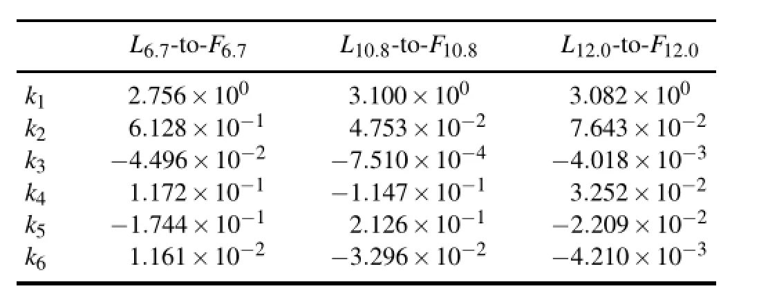
Table 1.The coeffcients in Eq.(1)for each channel used for conversion of satellite-observed radiance(L)to irradiance(F).
whereF6.7,F10.8,andF12.0are the irradiances at 6.7,10.8, and 12.0µm,respectively;anda,b,c,anddare coeffcients determined by RTM simulations(Table 2).As shown in the equations,four OLR values are estimated using different methods:OLR12.0is determined from a second-order polynomial function of a 12.0µm channel(Eq.2,Ohring et al.,1984);OLR10.8+12.0is estimated from a frst-order polynomial function of F10.8and F12.0(Eq.3,Inoue and Ackerman,2002);OLR6.7+10.8is calculated from a third-order polynomial function of 6.7 and 10.8µm(Eq.4,Schmetz and Liu,1988);and OLRAllis determined from a third-order polynomial function of all three IR channels[Eq.(5)].
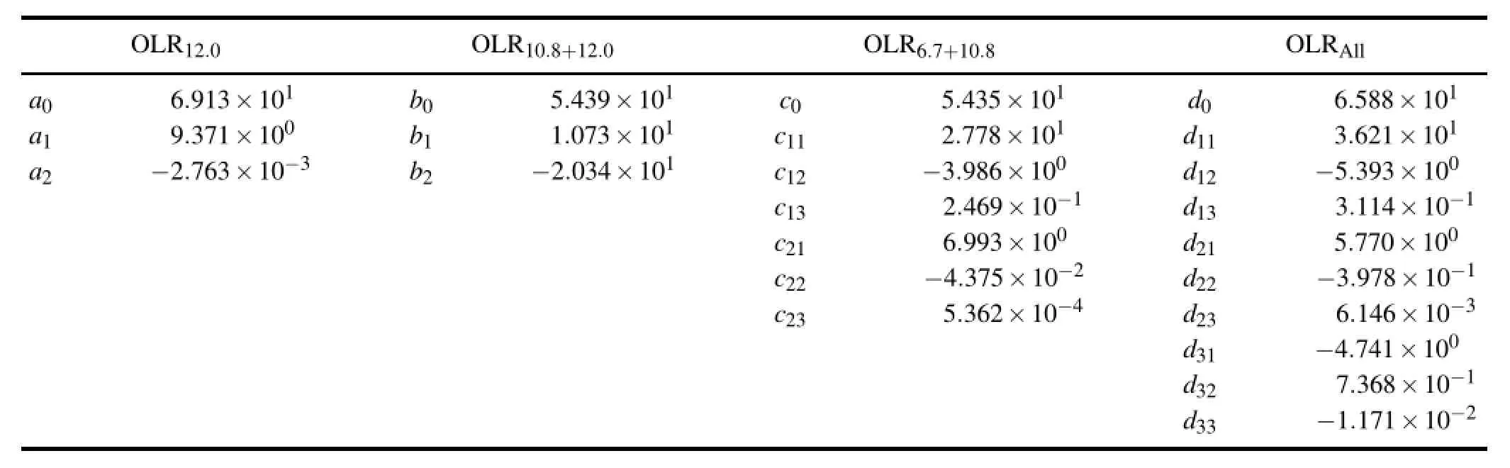
Table 2.The coeffcients in Eqs.(2–5)for OLR algorithms used for conversion of narrowband irradiance(F)to OLR.
The different method/functionmay be based on the physical relationship betweenFand OLR,which is likely dependent on the selected domain.Over the range of terrestrial temperatures,the fux on the window channel is essentially linear with total black body irradiance for the same temperature(Minnis et al.,1995).The domain of Inoue and Ackerman(2002)is the subtropical eastern Pacifc,where extreme highorlow OLRs(usuallyobservedoverdesertareas ortropical deep continental convection)are absent.Thus,a linear regression function of infrared channel and the window split channel[Eq.(3)]may be somewhat acceptable.For an extremely low IR temperature,the contribution of the IR spectral interval to the total blackbody irradiance asymptotically approaches zero while the longwave fux remains substantially greater than zero(Minnis et al.,1995).Thus,the role of the second-order polynomial function[Eq.(2)]is to permit this asymptotic behavior.The third-order polynomial regression function[Eq.(4)]seems more fexible in applying suitable F–OLR relations both over an extreme low and high OLR ranges.This is because the function has an infection point,enabling the algorithm to have decreased/increased slope of the function below/above the point(not shown).
3.2.Estimating coeffcients from theoretical calculation
As shown in Fig.2a,the coeffcients in the above equations are determined by regression analyses ofFonL[for the ks in Eq.(1)]and of OLR onF[for the as,bs,cs, and ds in Eqs.(2–5)].TheL,F,and OLR values are obtained fromtheoretical RTM calculations(e.g.,Ellingson and Ferrado,1983;Schmetz and Liu,1988;Ba et al.,2003). In this study,the discrete ordinates radiative transfer(DISORT)model,“Santa Barbara DISORT Atmospheric Radiative Transfer”(SBDART;Ricchiazzi et al.,1998),is used. TheRTM simulationsaredesignedto applyspectralresponse functions to COMS channels.
Various cloud and atmospheric conditions are assumed in the calculation of radiances and irradiances for the COMS channels(L6.7(θ),L10.8(θ),L12.0(θ),F6.7,F10.8,andF12.0), and OLR values.These conditions are fve cloud optical thicknesses(8,16,32,64,128),eight cloud top heights(2, 4,6,8,10,12,14,16 km),and seven typical atmospheric profles(i.e.,US62 standard,tropics,midlatitude summer, midlatitude winter,sub-arctic summer,sub-arctic winter,and desert).The vertical profles of environmental pressure,temperature,specifc humidity,andozonemass concentrationare obtainedfromMcClatcheyetal.(1972)intheSBDART RTM package,except for the desert condition.
The desert profle is set to have the same pressure and ozone profles as the tropics profle,but 20%of the specifc humidity(in g cm-2)and 110%of the temperature(in K). Note that this desert profle setting is artifcially obtained from the tropical sounding.Therefore,the desert profle set in this study may not be representative of all desert areas overthe tropics,midlatitudes,and those with wet and dry soil moisture levels.However,the current setting is reasonable in simulating extremely high OLR values that are actually observed over a desert area by the CERES sensor.Without this profle setting,the previous set of RTM simulations that only considered the desert surface condition were unable to simulate such high OLR values.Thus,the previous algorithm based on these simulations caused serious biases in all OLR algorithms over the desert area.Although the current atmospheric setting is somewhat artifcial,it is reasonable in retrieving reasonable OLR values for all desert areas(except for day/clear scenes for some OLR retrieval methods).
The minimal cloud optical thickness for the radiative calculationis 8 becausethe radiativetransfersimulationsshow a nearly one-to-one correspondence betweenLandFfor thick clouds only(coeffcient of determinationR2=99.6%).For opticallythinclouds(opticalthickness<8),the simulatedL–Fcorrelationis muchlower(R2=91.5%).Therefore,greater uncertainty in the OLR retrievals may be inevitable for thinner clouds.
For estimating OLR from COMS observations(Fig.2b), it is diffcult to consider all different surface types over the full COMS FOV(Fig.1),and classifcation of surface types is not carried out in this study.Accordingly,all RTM simulations(Fig.2a)are designed to have an“ocean”surface type, and the ocean’s spectral emission function is applied.Here, an assumptionis thatF–OLR(L–F)relationshipsfromocean surface simulations are almost consistent with theF–OLR relationships over other surfaces(e.g.,land,desert).The coeffcients from ocean RT simulations are then applicable for estimatingOLR overall surfacetypes.Usingthecoeffcients, it is inevitablethat the COMS OLR retrievals mayhave lower accuracy over land than over the ocean,which is confrmed in section 4.
The number of streams used in the DISORT model is 20forL-to-Fconversions and 4 for F-to-OLR conversions.The spectral resolution is 0.1 cm-1forLandFcalculations and 0.005µm for OLR calculations within the range of 4 to 100 µm.The simulations assume a plane-parallel atmosphere, and every radiative quantity is defned at an altitude of 100 km with zero solar zenith angle and zero relative azimuth angle.Nine satellite zenith angles(θ)are used forL(θ)calculations,from 0 to 80°at 10°intervals.
In accordance with most operational OLR algorithms (e.g.,Ohringet al.,1984),this study derivesa single set of regression coeffcients for eachF-to-OLR conversion[i.e.,as, bs,cs,and ds in Eqs.(2–5)].The coeffcients obtained in this study are listed in Table 2.That is,the current algorithms use uniform coeffcients for all pixels,similar to those of Ohring et al.(1984)and Ba et al.(2003),whereas Inoue and Ackerman(2002)constructed multiple sets of coeffcients for different cloud types or altitudes.As described later,the current validationshow that reasonable accuracyof OLR retrievals is possible even without separation of cloud typesbThis discussion does not necessarily indicate that OLR retrievals are insensitive to cloud types.It is possible that the algorithm can be further improved with the separation of cloud types..
In the radiative transfer simulations,the desert profle is responsible for very differentsimulations from other profles, such that the determination of the coeffcients in Eqs.(2–5) is subject to the inclusion of the desert simulations.To clarify the effect of the desert profle,Fig.4 depicts the scatter plots of RTM-simulated irradiances for(a)F6.7,(b)F10.8,and (c)F12.0versus RTM-simulated OLR.Because of the high surface temperature and dry atmosphere,theFand OLR in desert conditions(red open circles)can have much higher OLR values,which cannot be obtained under the other conditions(black crosses).To examine whether the inclusion of the desert simulation is necessary for calculating the coeffcients,we attempt to derive a new set ofF-to-OLR coeffcients(a,b,c,and ds)by excluding the desert cases.The coeffcients obtained without the desert simulation are found to cause large errors in all OLR algorithms(not shown),as they cannot cover actual OLR value ranges(>300 W m-2)from the COMS FOV,which includes the Australian desert area. The simulated OLR(or radiances)should cover a realistic OLR range in developingsuch regression models.Therefore, we have included the desert simulations for the fnal calculation of the coeffcients.
Note that,among the three irradiances(F6.7,F10.8,andF12.0in Fig.4),F12.0has the closest linear relationship with OLR,as seen by the smallest spread in theF12.0–OLR plot (Fig.4c).On the other hand,theF6.7–OLR relationship (Fig.4a)exhibits a large degree of scattering,particularly forF6.7>3 W m-2µm-1,because–unlike the window channels—the 6.7µm channel is fairly sensitive to columnintegratedhumiditydueto thesignifcant watervaporabsorption in the upper troposphere(between approximately 200 and 500 hPa)(Choi et al.,2007).Insofar as F and OLR values decrease with increasing cloud top height,it is natural that the spread is narrow forF6.7<2 W m-2µm-1because there should be little water vapor above high clouds.
3.3.Estimating the intrinsic accuracy of OLR
In this subsection,we attempt to estimate the intrinsic accuracy of each OLR algorithm.The intrinsic accuracy is defned as the accuracy induced by the algorithm equation(correspondingtoF-to-OLRconversionaswell asL-to-Fconversion).This intrinsic accuracy can be obtained by comparison between(1)OLR retrieved from each algorithm with RTM-simulatedF,and(2)an RTM-simulated OLR.Here,the errors in theL-to-Fconversionsare assumed to be small due to a near one-to-one relation betweenLandFdue to the proper consideration of the viewing geometry[Eq.(1)].However,it should also be noted that theL–Frelation could be uncertain for optically thin clouds(as shown in the previous section) and for satellite zenith angles larger than 70°(Ellingson and Ferrado,1983).
Table 3 shows the intrinsic accuracies of COMS OLR in terms of RMSEs and maximum errors.Overall,the single channel algorithm OLR12.0has the lowest accuracy:9.07 W m-2RMSE and 26.63 W m-2maximum error.The additional use of the 10.8µm channel does not seem to have any signifcant impact on the accuracy.The RMSE of OLR10.8+12.0is 8.34 W m-2and the maximum error is 26.09 W m-2;the change of RMSE is only 0.6 W m-2,and there is almost no change in maximum error compared to OLR12.0. Finally,it is concluded that the intrinsic accuracies of the OLR6.7+10.8and OLRAllalgorithms are better than the other twomethods(2.22Wm-2RMSEand5.69W m-2maximum error for OLR6.7+10.8;1.92 W m-2RMSE and 5.47 W m-2maximum error for OLRAll).The actual accuracy of COMS OLR retrievals may also be affected by many other factors, such as channel calibration and instrument stability,which is examined in the next section.
4. Validation
4.1.Comparison with CERES OLR
Here,we show comparison results between COMS OLR and CERES OLR as reference data.Figure 5 displays the scatter plots of the comparisons of(a)OLR12.0, (b)OLR10.8+12.0,(c)OLR6.7+10.8,and(d)OLRAllwith CERESOLRfortheperiod1–30April2011.Thedotsineach graph represent the 40 494 homogeneousgrids.For OLR12.0,OLR10.8+12.0,OLR6.7+10.8,andOLRAll,theregressionslopes are 0.86,0.96,0.93,and 0.95,respectively;the mean differences(biases)from CERES OLR are 3.06,1.01,-5.56,and -5.80 W m-2,respectively;and the RMSEs are 8.64,7.97, 6.08,and 5.58 W m-2,respectively.Most of the RMSEs originate from large spreads in the intermediate OLR values (200 W m-2<CERES OLR<300 W m-2in Fig.5)for all four OLRs.Such errors may be caused by short-term variations of broken clouds and/or of cloud top heights(Ba et al., 2003).
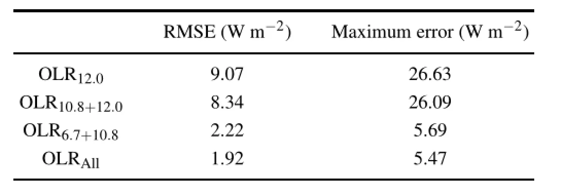
Table 3.The intrinsic accuracies of the four OLR algorithms estimated based on comparison between OLR retrievals from RTM-simulatedFand RTM-simulated OLR.
The accuraciesof all the OLRs are within the rangeof 5.5 to 8.7 W m-2(i.e.,2.0%–3.2%of the mean CERES OLR, 274 W m-2).The values in the present study are slightly smaller than those of Ohring et al.(1984)(~11 W m-2)andcomparable with those of Ba et al.(2003)(~7 W m-2).It should be noted that the area of the present study covers most of the full geostationary satellite FOV,whereas Ba et al.(2003)covers continental United States and surrounding oceans.Taking the various atmospheric and surface conditions included in the COMS coverage into account,the accuracy in our OLR retrievals seems appropriate for drawing general conclusions.
It is also notable that the single-channel algorithm OLR12.0tends to overestimate OLR values(particularly, CERES OLR>300 W m-2in Fig.5a).The bias of OLR12.0is 3.06 W m-2,and the∆OLR12.0/∆OLRCERES(∆OLRCERES/∆OLR12.0)regression slope is 1.16(0.86). Ohring et al.(1984)states that positive bias exists in the single-window channel OLR algorithm because samples of atmospheric soundings in RT simulations may not be representative of real atmospheric profles.Based on Fig.2,we determine that theF12–OLR regression has a higher slope for desert cases(red circles)than for the other cases(black crosses).That is,the greater relative contribution of desert cases in simulations(one of seven atmospheric soundings in RTM simulations,as in section 3.2)than in real observational cases(2062 desert grids of 40 495 total grids for COMS validation,Table4)maycausethecoeffcientsinEq.(2)tohavea higher regression slope,which will fnally lead to positive biasesinOLR12.0retrieval.Thiskindoftendencyalsooccursin the other three algorithms,but to a lesser degree(Figs.5b-d). On the other hand,the RMSE of OLR10.8+12.0is smaller than the RMSE of OLR12.0.In addition,the bias of OLR10.8+12.0is the smallest among all OLRs.These improved statistics imply that the radiance difference between the split window channels(10.8 and 12.0µm)may well correct the effects of atmospheric water vapor in clear-sky conditions where most of the high OLR values are present(Inoue and Ackerman, 2002).This improvement is important because,on average, clear-sky scenes constitute about 38%of the entire domain (Table 5).
Both OLR6.7+10.8and OLRAllare from the algorithm using a 6.7µm water vapor channel.Interestingly,OLR6.7+10.8and OLRAllshow smaller RMSEs than the other two OLRs. This smaller RMSE may be becauseF6.7provides adequate information for resolving the tropospheric water vapor absorption,which cannot be captured in window-channel algorithms.Despite employing all three irradiances,we note that OLRAlldoes not show a decisive superiority to OLR6.7+10.8, which indicates that the additional inclusion ofF12.0does not improve the accuracy of OLR6.7+10.8.This may be because the combination ofF6.7andF10.8has enough degrees of freedom to resolve variations in OLR.Ellingson et al.(1989) showed that the channels for OLR retrieval from the High Resolution Infrared Radiation Sounder,centered at 13.3,6.7, 8.2,and 14.4µm,explained 96.4%,1.8%,1.1%,and 0.5% of the OLR variations,respectively.This confrms that in addition to surface or cloud top information from one window channel,the upper tropospheric humidity represented by the 6.7µm channel is crucial for increasing the accuracy of OLR retrievals.Specifcally,a combination of one window channel and one water vapor channel can capture more than 98% of the OLR variability.
The RMSE of OLR6.7+10.8(6.08 W m-2in Fig.5c)is larger than its algorithm intrinsic accuracy(2.22 W m-2in Table 3)estimated from RTM simulations.In contrast,the RMSEs of OLR12.0and OLR10.8+12.0are smaller than their algorithm intrinsic accuracies(Table 3).This may be due to differences in the relative contribution of environmental conditions between the COMS FOV(i.e.,a larger contribution of the wide Pacifc Ocean than the Australian desert)and the RTM environments(i.e.,equal contributions of tropicalocean and desert simulations).Thus,the desert case would lower the accuracy in the 12µm channel more for the RTM simulation than for COMS observations.
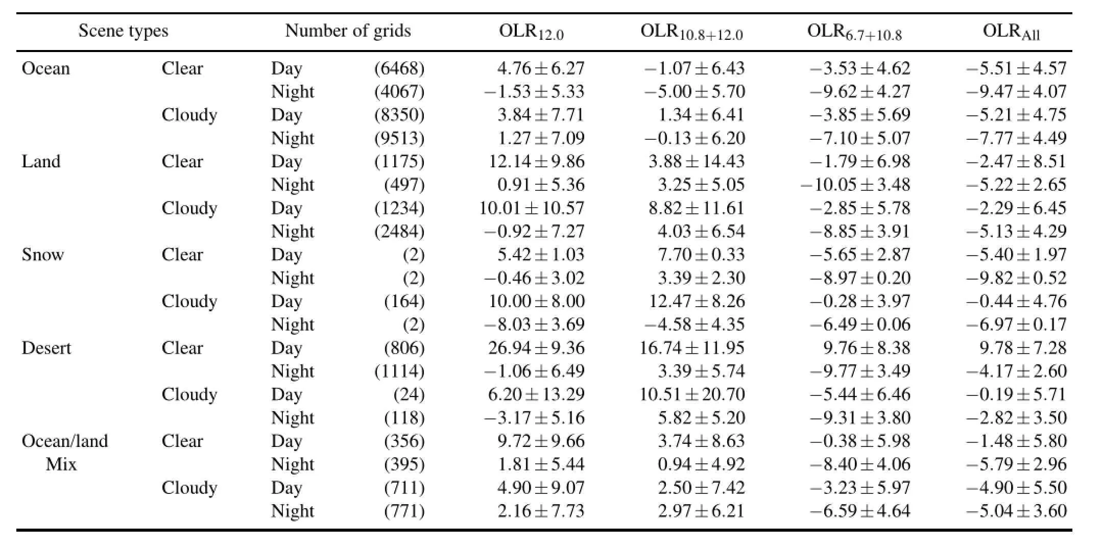
Table 4.The accuracies of COMS OLR versus CERES OLR for various scene types(bias±RMSE,in W m-2).
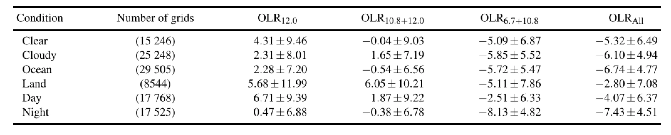
Table 5.The accuracies of COMS OLR versus CERES OLR for different environmental conditions(bias±RMSE,in W m-2).
4.2.Dependence of OLR accuracy on the environment
To better understand the major causes of the decreasing accuracy in the OLR retrievals,dependence on various conditions is tested.Following the original classifcation of the ERBE scene(Diekmann and Smith,1989)available in the CERES data,a cloudiness condition of a 1°×1°grid is classifed in terms of cloud fraction:clear(less than 5%cloudy); partly cloudy(5%–50%cloudy);mostly cloudy(50%–95% cloudy);and overcast(more than 95%cloudy).Figure 6 shows overall statistics of the CERES observations for the 40 494 homogeneous 1°×1°grids(the sample numbers are indicatedby the bar graphs,and the OLR values are indicated by the plot graphs).Categories with less than 30 grids are not shown.As the COMS FOV covers a large proportion of the western Pacifc,most of the grids are classifed as ocean scenes.The number of snow scenes is small because the high-latitude regions are barely observed from geostationary orbit.Based on the analysis of CERES OLR distributions in Fig.6,the OLR decreases with increasing cloudiness due to the colder temperaturesof cloud tops comparedto the Earth’s surface.
On the whole,OLR12has a positive bias by day,but no signifcant bias by night(Table 4).The positive daytime biases of OLR12.0over most surface types except snow tend to be larger over clear regions than cloudy regions.For instance,in the case of ocean surfaces in the daytime,4.76 W m-2for the clear region is larger than 3.84 W m-2for the cloudy region(Table 4).The larger positive bias over the clear region than the cloudy region is associated with overestimation of high OLR and underestimation of low OLR,as explained in the previous subsection.Such large positive biases in the single-channel algorithm can be corrected by the additional use of the 10.8µm channel;OLR10.8+12.0shows reduced positive biases for clear conditions,especially over ocean surfaces,although the overall RMSEs are not greatly improved.
As expected from Figs.5c and 5d(the accuracy for all cases),OLR6.7+10.8and OLRAllhave smaller RMSEs than OLR10.2and OLR10.8+12.0,regardless of surface type(Table 4).Forthe oceansurfacetype,the RMSEs ofOLR6.7+10.8are 4.27 to 5.69 W m-2,and the RMSEs of OLRALLare 4.07–4.75 W m-2.These values are about 1–2 W m-2smaller than the RMSEs of the other two methods,OLR10.2and OLR10.8+12.0.Also,the biases of OLR6.7+10.8and OLRAll are negative for all surface types in both clear and cloudy conditions(Table 4).However,these biases are systematic and can simply be reduced by an adjustment of coeffcients.
The case of desert conditions in the daytime requires more discussion because the differences in OLR between COMS and CERES for that case are exceptionally large(Table 4).As seen in Fig.4(the RTM simulations),OLR is quite sensitive to spectral Fs.A small bias inFwould lead to a large bias in OLR in the present simplifed regression approach for extremely dry atmosphere and hot surface(during the daytime)conditions.Moreover,the biases of OLR in the daytime are much larger than at nighttime over the desert. Thisis also clearlyshowninFig.7,whichpresentsthescatter plots of COMS versus CERES OLRs for the desert in daytime(red)and at nighttime(blue).Although daytime positive biases exist for all four OLRs,the biases of OLR12and OLR10.8+12.0(26.94 and 16.74 for desert clear-sky scenes in Table4)aremuchlargerthanthoseoftheothertworetrievals. In contrast,the nighttime negative bias is noticeable only for OLR6.7+10.8.
Table 5 summarizes the dependence of OLR accuracies on various environmental conditions.In all four algorithms, the RMSE is signifcantly smaller over the ocean than over land.Theocean–landcontrastislargestforOLR12.0;theRMSEs are 7.20 W m-2for the ocean and 11.99 W m-2for the land.The biases for OLR12.0are also smaller over the ocean than over land(2.28 W m-2for the ocean,5.68 W m-2forland),as are the biases for OLR10.8+12.0(-0.54 W m-2for the ocean,6.05 W m-2for land).The large difference between over the land and ocean may be attributed to improper specifcations of surface emissivity.It is well known that the complicated structure of land surface emissivity is diffcult to refect in several narrowband radiances and could lead to inherentOLR errors(SchmetzandLiu,1988;InoueandAckerman,2002;Ba et al.,2003).
For clear-sky conditions,the RMSEs are slightly larger than those for cloudy sky conditions;for example,the RMSE ofOLR6.7+10.8is 6.87W m-2forclearskies and5.52W m-2for cloudy skies(Table 5).Specifcally,the accuracy of OLR for cloudy skies is quite high over the full COMS FOV,despite the highly variable properties of clouds.This supports the feasibility of the current OLR algorithm,which does not incorporate complex cloud properties as input variables.Table 5 also shows that the accuracy of OLR is better at nighttime than in the daytime.Compared to the CERES OLR, the nighttime OLR errors are smaller by 2.51 W m-2for OLR12.0,2.44 W m-2for OLR10.8+12.0,and 1.51 W m-2 for OLR6.7+10.8.The day/night dependence may be associated with the warm/cold temperatures;that is,the errors tend to be larger for a high OLR range(see Fig.5),which is observed more frequently in the daytime.Note that the same explanation can be applied to the larger errors over the land surface than the ocean surface,or the larger errors with clearsky scenes compared to cloudy skies.
Severalpreviousstudies(e.g.,Otterman et al.,1997)have pointed out the strong link betweenL-to-Fconversion error and satellite zenith angle.Therefore,we examine the OLR errors and biases depending on satellite zenith angle in Table 6.Specifcally,with an increase in satellite zenith angle from 0°–30°to 60°–90°,the negative biases of the two OLRs using the 6.7µm water vapor channel increase from 0.00 to-8.56 W m-2for OLR6.7+10.8and from-1.39 to 8.68 to W m-2for OLRAll.Therefore,the negative biases of OLR6.7+10.8and OLRAll(shown in Table 4)are attributed to the water vapor channel for higher satellite zenith angles (>60°).In contrast,for OLR10.2and OLR10.8+12.0,the positive bias increases when approaching the nadir point(from -0.12 to 9.30 W m-2for OLR12.0and from-0.65 to 3.41 W m-2for OLR10.8+12.0).The bias characteristics of OLRs depending on the satellite zenith angles are related to the regional distributions of the bias of OLR(Fig.8).A larger bias at the nadir point implies that the limb darkening effect of the atmosphere still remains signifcant in the irradiance cal-culation and is not eliminated through the estimated relation betweenL(θ)and F[Eq.(1)].
5. Conclusion
This study has attempted to evaluate four OLR retrieval algorithms(OLR12.0,OLR10.8+12.0,OLR6.7+10.8,and OLRAll)with different combinations of the three best channels(10.8,12.0,and 6.7µm)on a geostationary satellite. The OLR retrieval algorithms were constructed on the basis of the coeffcients(Tables 1 and 2)of calculated regression analyses of RTM simulations ofL,F,and OLR(Section 3). The RTM simulations were performed for various surface, atmospheric,and cloud conditions,given the spectral characteristics of COMS.Using COMS radiance observations,the OLRs from the four different methods were retrieved for the period of 1–30 April 2011(Fig.2b).The retrieved OLRs were collocated with the CERES OLR on 1°×1°grids,and validation was performed only for“homogeneous grids”as in Ba et al.(2003).
It was hypothesized to be a challenging task to have consistent and appropriate accuracy of COMS OLR over the full FOV[roughly(50°S–50°N,70°–170°E),as shown in Fig.1] due to diversities in surface conditions,atmospheric profles, seasons,etc.The comparison between COMS OLR and the collocated CERES OLR over a broad domain shows good agreement within RMSEs of 5.5 to 8.7 W m-2(Fig.3).The errors in this study are smaller than the 11 W m-2RMSE reported by Ohring et al.(1984),but comparable to the 7 W m-2RMSE reported by Ba et al.(2003).The error between GOES OLR and CERES OLR in Ba et al.(2003)is fromvalidationoverthe Americancontinentandsurrounding oceans.Compared to this previous study,the current validation domain includes a much larger ocean area,which could contribute to higher OLR accuracy.However,we also have a larger satellite zenith area,which would lower the OLR accuracy.As a result,our validation results show smaller or similar accuracies compared to Ba et al.(2003).Therefore, it is believed that COMS OLR retrievals are in reasonable agreement with CERES OLR.
The important conclusion of this study is the determination of differences in the four OLR methods using the same geostationary satellite(Fig.5).Overall,the errors of OLRAlland OLR10.8+6.7(5.58 to 6.08 W m-2RMSE)are smaller than those of OLR10.8+12.0and OLR12.0(7.97 to 8.64 W m-2RMSE),implying that the water vapor channel has a significant role in OLR retrievals.cWe also assume that the use of the third-order polynomial function of these two methods allow the algorithms to have more fexible IR–OLR relationships that are suitable both over extremelylow and high OLR ranges.Althoughsome negativebiases of about 5 W m-2exist for OLR10.8+12.0and for OLRAll,they can be removed by proper adjustment of the offset coeffcients in the algorithms.
In all four methods,the errors are about 2–3 W m-2smaller over the ocean than over land,and the biases are also smallerovertheocean(-0.54W m-2overtheoceanvs.6.05 W m-2overlandforOLR10.8+12.0,Table5).Becausethecurrent OLR algorithms do not consider the variation of surface emissivity over land,the accuracy of the OLR retrievals is better overthe ocean than over land.In addition,largererrors for COMS OLR retrievals in the daytime compared to nighttime are evident(Table 5)because the errors tend to be larger for higher OLR values,as in Fig.5.Our analyses have also revealed a slightly larger error for clear skies than for cloudy skies:e.g.,the RMSE of OLR6.7+10.8is 6.87 W m-2forclear skies and5.52W m-2forcloudyskies(Table5).Theseaccuracies in OLR for cloudy skies seem to be good enough over the full COMS FOV despite the large variation in the cloud properties(e.g.,cloud top height or thickness).Although cirrus cloud cases are known to be problematic for estimating OLR,the dependence of the accuracy on cloud type was not investigated in the current study.
COMS OLR is highly biased relative to CERES OLR for deserts in the daytime,which is one of the challenging cases for obtaining high OLR accuracy,as discussed in Ellingson et al.(1994).It is believed that such biases may be later improved by more realistic desert atmospheric profles in RTM simulations,and also by consideration of each pixel’s surface types in OLR algorithms.Our analyses also revealed positive biases of COMS OLR over the area with high satellite zenith angles.The biases could be attributable to incomplete elimination of the limb darkening effect byL–Fconversion in the RTM calculation.In addition,because the CERES has viewing angles ranging only from 0°to 51°for FM1, different satellite viewing angles of the COMS and CERES can be another factor causing positive biases of COMS from higher viewing angles.It is possible that the dependence of the accuracy on various environmental factors can be conditionally improved by constructing an algorithm that uses different coeffcients[in Eqs.(1–5)]for each individual scene type.However,this attempt to improve the accuracy may cause problems,such as computing time delay or degradation of the consistency and spatial homogeneity of retrievals.
Three of the OLR algorithms,i.e.,OLR12,OLR10.8+6.7, and OLR10.8+12.0,have been implemented in the operational COMS Meteorological Data Processing System,along with other retrieval algorithms for meteorological variables(e.g., Oh et al.,2006;Choi et al.,2007;Park et al.,2007;Yoon et al.,2007;Kim et al.,2008;Lee et al.,2011;Park et al., 2012).This study shows that the accuracies of the three OLR algorithms appear to be higher than,or similar to,other OLR algorithms;further improvement of the OLR retrievals may be possible by adjusting coeffcients in the OLR algorithms basedonthe validationresultswith theCERES OLR.Theadjustedalgorithmsbasedonthe validationresultsyieldsmaller RMSEs:7.35,7.91,5.71 and 5.42 W m-2for OLR12.0, OLR10.8+12.0,OLR6.7+10.8and OLRAll,respectively.
The validation results of this study are particularly valu-able for comparing the COMS OLR and CERES OLR over the full geostationary satellite FOV,whereas previous evaluation studies are limited to specifc regions.Therefore,the following rules are suggested to determine the optimal algorithm(s)for obtaining reasonable accuracies over the full geostationary satellite FOV.
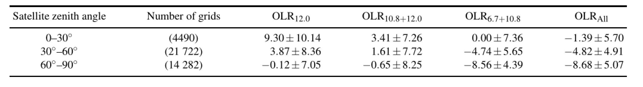
Table 6.The accuracies of COMS OLR versus CERES OLR for different satellite zenith angles(bias±RMSE,in W m-2).
(1)If the systematic biases are corrected,the OLR10.8+6.7and OLRALLalgorithm will be suggested over a vast domain including various surface and cloud conditions due to the consistently good accuracies.Considering computational effciencies,the OLR10.8+6.7method using the two channels only may be optimal due to spending less computational resources than the OLRALL.
(2)The present results also imply that the OLR retrieval algorithms could be specifcally selected for different domains.In the case of retrieving OLRs over ocean regions, as in Inoue and Ackerman(2002),the OLR10.8+12.0method is a reasonable choice since the RMSE in ORL10.8+12.0is not so differentfromthosein OLR6.7+10.8andOLRALLforocean conditions.For a desert surface,the application of OLR12.0or OLR10.8+12.0methods is not recommended due to more severe errors for clear and daytime scenes.
ThecurrentvalidationresultsconfrmasuccessfulCOMS OLR retrieval and can also provide important guidelines for designingOLR algorithmsfornext-generationsatellites.Furthermore,the present results could be informative for assim-ilation of satellite-observed OLR in numerical models,or for scientifc applications focusing on atmospheric processes.
Acknowledgements.This study was supported by the Korea Meteorological AdministrationResearchandDevelopment Program (Grant No.CATER 2012-2040).This manuscript was fnalized during the frst author’s UNIST Research Scientist appointment at UNIST,Korea.
REFERENCES
Abel,P.G.,and A.Gruber,1979:An improved model for the calculation of longwave fux at 11µm.NOAA Technical Report, NESS 106,NTIS PB80-119431,24 pp.
Ba,M.B.,R.G.Ellingson,and A.Gruber,2003:Validation of a technique for estimating OLR with the GOES sounder.J. Atmos.Oceanic Technol.,20,79–89.
Barkstrom,B.,E.Harrison,G.Smith,R.Green,J.Kibler,R.Cess, and the ERBE Science Team,1989:Earth Radiation Budget Experiment(ERBE)archival and April 1985 results.Bull. Amer.Meteor.Soc.,70,1254–1262.
Cho,H.,C.-H.Ho,and Y.-S.Choi,2012:The observed variation in cloud-induced longwave radiation in response to sea surface temperature over the Pacifc warm pool from MTSAT-1R imagery.Geophys.Res.Lett.,39,L18802,doi: 10.1029/2012GL052700.
Choi,Y.-S.,and C.-H.Ho,2006:Radiative effect of cirrus with different optical properties over the tropics in MODIS and CERES observations.Geophys.Res.Lett.,33,L21811,doi: 10.1029/2006GL027403.
Choi,Y.-S.,C.-H.Ho,M.-H.Ahn,and Y.-M.Kim,2007: An exploratory study of cloud remote sensing capabilities of the Communication,Ocean and Meteorological Satellite (COMS)imagery.Int.J.Remote Sens.,28,4715–4732.
Diekmann,F.J.,and G.L.Smith,1989:Investigation of scene identifcation algorithms for radiation budget measurements.J.Geophys.Res.,94,3395–3412.
Ellingson,R.G.,and R.R.Ferrado,1983:An examination of a technique for estimating the longwave radiation budget from satellite radiance observations.J.Climate Appl.Meteor.,22, 1416–1423.
Ellingson,R.G.,and M.B.Ba,2003:A study of diurnal variation of OLR from the GOES Sounder.J.Atmos.Oceanic Technol., 20,90–98.
Ellingson,R.G.,D.J.Yanuk,H.-T.Lee,and A.Gruber,1989: A technique for estimating outgoing longwave radiation from HIRS radiance observations.J.Atmos.Oceanic Technol.,6, 706–711.
Ellingson,R.G.,H.-T.Lee,D.Yanuk,and A.Gruber,1994:Validation of a technique for estimating outgoing longwave radiation from HIRS radiance observations.J.Atmos.Oceanic Technol.,11,357–365.
Harries,J.E.,andCoauthors,2005:TheGeostationary EarthRadiation Budget project.Bull.Amer.Meteor.Soc.,86,945–960.
Hartmann,D.L.,and M.L.Michelsen,2002:No evidence for iris.Bull.Amer.Meteor.Soc.,83,249–254.
Ho,C.-H.,M.-D.Chou,and C.-H.Sui,2002:Comparison of different EarthRadiation Budget Experiment data sets over tropical oceans.Int.J.Climatol.,22,263–270.
Ho,C.-H.,M.-S.Park,Y.-S.Choi,and Y.N.Takayabu,2008:Relationship between intraseasonal oscillation and diurnal variation of summer rainfall over the South China Sea.Geophys. Res.Lett.,35,L03701,doi:10.1029/2007GL031962.
Inoue,T.,and S.A.Ackerman,2002:Radiative effects of various cloud types as classifed by the split window technique over theeasternsub-tropical Pacifcderivedfromcollocated ERBE and AVHRR data.J.Meteor.Soc.Japan,80,1383–1394.
Jeong,J.-H.,C.-H.Ho,B.-M.Kim,and W.-T.Kwon,2005:Infuence of the Madden-Julian Oscillation on wintertime surface air temperature andcold surgesinEast Asia.J.Geophys.Res., 110,D11104,doi:10.1029/2004JD005408.
Khaiyer,M.M.,D.R.Doelling,P.K.Chan,M.L.Nordeen,R.Palikonda,Y.Yi,and P.Minnis,2006:Derivation of improved surface and TOA broadband fuxes using CERES-derived narrowband-to-broadband coeffcients.Preprints,12th AMS Conference on Atmospheric Radiation,Madison,Wisconsin, US.
Khaiyer,M.M.,P.Minnis,D.R.Doelling,R.Palikonda,M. Nordeen,Y.Yi,and D.Rutan,2011:Improved TOA shortwave and longwave broadband fuxes derived from the Southern Great Plains.Paper presented at 2011 Atmospheric Science Research Science Team Meeting,U.S.Dep.of Energy, San Antonio,Texas,March 28—April 1.[Available online at http://asr.science.energy.gov/meetings/stm/posters/poster pdf/ 2011/P000311.pdf.]
Kiehl,J.T.,J.J.Hack,and J.W.Hurrell,1998:The energy budget of the NCAR Community Climate Model:CCM3.J.Climate, 11,1151–1178.
Kim,J.,J.-M.Yoon,M.-H.Ahn,B.J.Sohn,and H.S.Lim, 2008:Retrieving aerosol optical depth using visible and mid-IR channels from geostationary satellite MTSAT-1R.Int.J. Remote Sens.,29,6181–6192.
Lau,K.M.,and P.H.Chan,1983:Short-term climate variability and atmospheric teleconnections from satellite-observed outgoing longwave radiation.Part I:Simultaneous relationships.J.Atmos.Sci.,40,2735–2750.
Lau,K.M.,C.-H.Ho,and M.-D.Chou,1996:Water vapor and cloud feedback over the tropical oceans:Can we use ENSO as a surrogate for climate change?Geophys.Res.Lett.,23, 2971–2971.
Lee,J.-R.,J.-Y.Chung,and M.-L.Ou,2011:Fog detection using geostationary satellite data:Temporally continuous algorithm.Asia-Pacifc J.Atmos.Sci.,47,113–122.
Lindzen,R.S.,and Y.-S.Choi,2009:On the determination of climate feedbacks from ERBE data.Geophys.Res.Lett.,36, L16705,doi:10.1029/2009GL039628.
Lindzen,R.S.,and Y.-S.Choi,2011:On the observational determination of climate sensitivity and its implications.Asia-Pacifc J.Atmos.Sci.,47,377–390.
Lindzen,R.S.,M.-D.Chou,and A.Y.Hou,2001:Does the earth have an adaptive infrared iris?Bull.Amer.Meteor.Soc.,82, 417–432.
Madden,R.,and P.Julian,1971:Detection of a 40–50 day oscillation in the zonal wind in the tropical Pacifc.J.Atmos.Sci., 28,702–708.
McClatchey,R.A.,R.W.Fenn,J.E.A.Selby,F.E.Volz,and J.S. Garing,1972:Optical properties of the atmosphere.3RD ed,AFCRL Environment Research Papers,Vol.411,108 pp.
Minnis,P.,and W.L.Smith Jr.,1998:Cloud and radiative felds derived from GOES 8 during SUCCESS and the ARM-UAV Spring 1996 fight series.Geophys.Res.Lett.,25,1125–1128.
Minnis,P.,W.L.Smith Jr.,;D.P.Garber,;J.K.Ayers,and D.R. Doelling,1995:Cloud properties derived From GOES-7 forthe spring 1994 ARM intensive observing period using version 1.0.0 of the ARM satellite data analysis program.NASA RP 1366,August 1995,59 pp.
Oh,H.-R.,Y.-S.Choi,C.-H.Ho,and M.-H.Ahn,2006:Development of sky cover retrieval algorithm for the Communication, Ocean and Meteorological Satellite(COMS)imagery.Asia-Pacifc J.Atmos.Sci.,42,389–396.
Ohring,G.,A.Gruber,and R.Ellingson,1984:Satellite determination of the relationship between total longwave fux and infrared window radiance.J.Climate Appl.Meteor.,23,416–425.
Otterman,J.,D.Starr,T.Brakke,R.Davies,H.Jacobowitz,A. Mehta,F.Cheruy,and C.Prabhakara,1997:Modeling zenithangle dependence of outgoing longwave radiation:implication for fux measurements.Remote Sens.Environ.,62,90–100.
Park,J.-H.,J.-Y.Ha,S.-M.Park,and K.-M.Lee,2007:Validation of upper tropospheric humidity inferred from the water vapor channel of geostationary satellites for the summer season in the east Asian region.Asia-Pacifc J.Atmos.Sci.,43, 223–237.
Park,M.-S.,C.-H.Ho,J.Kim,and R.L.Elsberry,2011:Diurnal circulations and their multi-scale interaction leading to rainfall over the South China Sea upstream of the Philippines during intraseasonal monsoon westerly wind bursts.Climate Dyn.,37,1483–1499.
Park,J.,M.Ou,S.Kim,and H.Cho,2012:Sensitivity of satellitederived wind retrieval over cloudy scenes to target selection in tracking and pixel selection in height assignment.IE Geosci.Remote Sens.,50,2063–2073.
Ricchiazzi,P.,S.Yang,C.Gautier,and D.Sowle,1998:SBDART: A research and teaching software tool for plane-parallel radiative transfer in the earth’s atmosphere.Bull.Amer.Meteor. Soc.,79,2101–2114.
Schmetz,J.,and Q.Liu,1988:Outgoing longwave radiation and its diurnal variation at regional scales derived from METEOSAT.J.Geophys.Res.,93,11192–11204.
Sinha,A.,and J.E.Harries,1997:The earth’s clear-sky radiation budget and water vapor absorption in the far infrared.J.Climate,10,1601–1614.
Taylor,P.C.,2012:Tropical outgoing longwave radiation and longwave cloud forcing diurnal cycles from CERES.J.Atmos.Sci.,69,3652–3669.
Wielicki,B.A.,B.R.Barkstrom,E.F.Harrison,R.B.Lee,G.L. Smith,and J.E.Cooper,1996:Clouds and the Earth’s Radiant Energy System(CERES):An earth observing system experiment.Bull.Amer.Meteor.Soc.,77,853–868.
Yoon,J.M.,J.Kim,J.H.Lee,H.K.Cho,B.J.Sohn,and M.-H. Ahn,2007:Retrieval of aerosol optical depth over east Asia from a geostationary satellite,MTSAT-1R.Asia-Pacifc J.Atmos.Sci.,43,133–142.
Young,D.F.,P.Minnis,D.R.Doelling,G.G.Gibson,and T. Wong,1998:Temporal interpolation methods for the Clouds andtheEarth’sRadiant EnergySystem(CERES)Experiment.J.Appl.Meteor.,37,572–590.
:Park,M.-S.,C.-H.Ho,H.Cho,and Y.-S.Choi,2015:Retrieval of outgoing longwave radiation from COMS narrowband infrared imagery.Adv.Atmos.Sci.,32(3),375–388,
10.1007/s00376-014-4013-7.
(Received 20 January 2014;revised 18 June 2014;accepted 8 July 2014)
∗Corresponding author:Chang-Hoi HO
Email:hoch@cpl.snu.ac.kr
Validation results show that the root-mean-square errors of COMS OLRs are 5–7 W m-2,which indicates good agreement with CERESOLR over the vast domain.OLR6.7+10.8and OLRAllhave much smaller errors(~6 W m-2)than OLR12.0and OLR10.8+12.0(~8 W m-2).Moreover,the small errors of OLR6.7+10.8and OLRAllare systematic and can be readily reduced through additional mean bias correction and/or radiance calibration.These results indicate a noteworthy role of the 6.7µm water vapor absorption channel in improving the accuracy of the OLRs.The dependence of the accuracy of COMS OLRs on various surface,atmospheric,and observational conditions is also discussed.
杂志排行

Advances in Atmospheric Sciences的其它文章
- A Hybrid Coupled Model for the Pacif i c Ocean–Atmosphere System.Part I:Description and Basic Performance
- Processes Leading to Second-Year Cooling of the 2010–12 La Ni˜na Event,Diagnosed Using GODAS
- Characterization and Source Apportionment of Volatile Organic Compounds in Urban and Suburban Tianjin,China
- Processes Leading to Second-Year Cooling of the 2010–12 La Ni˜na Event, Diagnosed Using GODAS
- Incorporation of Parameter Uncertainty into Spatial Interpolation Using Bayesian Trans-Gaussian Kriging
- An Assessment of the Predictability of the East Asian Subtropical Westerly Jet Based on TIGGE Data