Lithofacies palaeogeography of the Late Permian Wujiaping Age in the Middle and Upper Yangtze Region, China
2014-09-27JinXiongLuoYouBinHeRuiWang
Jin-Xiong Luo, You-Bin He, Rui Wang
School of Geosciences, Yangtze University, Wuhan 430100, China
1 Introduction*
Lithofacies palaeogeography plays an important role in the prospecting and exploration of mineral resources.Hydrocarbon exploration shows that lithofacies palaeogeography has an inf l uence over the distribution of effective resource rock, reservoir and seal.Thus, lithofacies palaeogeography research is the basis of oil and gas exploration and exploitation.
Lithofacies palaeogeography mapping is the main task in the study of the lithofacies palaeogeography.In the 1970s, single factor analysis and multifactor comprehensive mapping method was initiated (Feng, 1977), and the core of this method is the quantitative palaeogeographic map.Quantity here means that on the palaeogeographic map, the division and identif i cation of each palaeogeographic unit are supported by the quantitative data and quantitative fundamental maps (Fenget al., 2014).Then,the quantitative lithofacies palaeogeography, which is an important discipline of palaeogeography was formed(Feng, 2009; and the references therein).In the 1990s,lithofacies palaeogeography which is guided by plate tectonics theory and basin analysis principles (Liu and Xu,1994)was developed.And, with the introduction, development and application of sequence stratigraphy, the sequence-based lithofacies palaeogeography maps emerged(Mouet al., 1992; Chenet al., 1999; Tianet al., 2004; Maet al., 2009), which regards the system tract or relative sequence boundaries as the mapping unit (Tianet al., 2004).Several scholars also applied the single factor analysis and multifactor comprehensive mapping methods to sequencebased lithofacies palaeogeography (Huet al., 2010).
The lithofacies palaeogeography of the Permian in South China has been the focus of past research (Fenget al., 1988; Li and Liu, 1988; Heet al., 1990; Fenget al.,1993, 1997; Chenet al., 1999), with a major breakthrough in hydrocarbon exploration of the Permian in northeastern Sichuan Province (Maet al., 2005a).Then research on the Permian in South China has been further strengthened, but almost all studies mainly placed emphasis on the Changxing Stage (Mouet al., 2004; Maet al., 2005b, 2006;Wanget al., 2011).The studies on the Wujiaping Stage are relatively rare (Tianet al., 2010).However, current exploration shows that the Wujiaping Stage also is a good hydrocarbon exploration prospect (Guo, 2011; Guo and Hu, 2011).Therefore, quantitative lithofacies palaeogeography research on the Upper Permian Wujiaping Stage in the Middle and Upper Yangtze Region must be conducted.
Based on a petrological study and combined with the latest exploration achievements, the quantitative lithofacies palaeogeography of the Late Permian Wujiaping Age in the Middle and Upper Yangtze Region was studied and mapped through single factor analysis and multifactor comprehensive mapping method in this paper.
2 Geological setting
Middle and Upper Yangtze Region in this study covers the provinces of Yunnan, Guizhou, Sichuan, Shaanxi,Hubei, Hunan and Jiangxi and Chongqing City, and ranges from the eastern longitude of 102° to 116° and from the northern latitude of 26° to 33° (Figure 1), which is approximately 500,000 km2.It extends to Baoxing-Guangyuan-Hanzhong in the northwest and to Hanzhong-Xiangyang-Jiujiang in the north.The range of the study area is almost equivalent to the Yangtze Block (Maet al., 2004).
The Permian is widely distributed in the Middle and Upper Yangtze Region, with a thickness of 400 m to 800 m.The Middle Permian Qixia Stage, Maokou Stage as well as the Upper Permian Wujiaping Stage and Changxing Stage can be found by conducting a detailed investigation.The distribution of the Lower Permian is rather limited to Majiaoba of the Jiangyou County in northwestern Sichuan (Liet al., 2005).The thickness of the Wujiaping Stage in the study area varies from less than 10 m to 388 m.The Wujiaping Stage unconformably overlies the Maokou Stage, whereas its contact to the overlying Changxing Stage is conformable.

The Wujiaping Stage in the study area mainly includes the lower member of the Xuanwei Formation, Longtan Formation and Wujiaping Formation.The subdivisions and their correlation of the Wujiaping Stage in the study area are shown in Table 1.
3 Methodology
Quantitative methodology, namely, single factor analysis and multifactor comprehensive mapping method, has matured over the practice of the past thirty years (Feng,1977, 1992, 2004, 2009), and has proven that this methodology is effective and plays a key role in quantitative lithofacies palaeogeography.The meaning of single factor(Feng, 2009; Fenget al., 2014)and the steps involved in the method (Heet al., 2013; Fenget al., 2014)are wellknown.
In this paper, six single factors were selected.These factors include thickness (m), content (%)of marine rocks,content (%)of shallow water carbonate rocks, content (%)of biograins with limemud, content (%)of deep water sedimentary rocks and content (%)of thin-bedded siliceous rocks.
The outcrop sections were divided into three orders,and the well sections were divided into two orders.The first-order outcrop sections were measured by us and all quantitative and qualitative data from the sections are reliable.The second-order outcrop sections were reviewed or partially measured by us, and all quantitative data are basically reliable.The third-order outcrop sections were measured and studied by previous researchers and were collected by us, these sections have a simple lithologic description and contain minimal quantitative data, in which only the thickness data are reliable.The first-order well sections were reviewed by us via the original logging data;in addition, we studied drill cores and thin sections under the microscope; all of these quantitative and qualitative data are reliable.The second-order well sections were reviewed by us also via the original logging data, the thickness data of which are reliable; but the other data can only be used as references.In this research, 17 first-order outcrop sections, 74 second-order outcrop sections, 207 thirdorder outcrop sections, 27 first-order well sections and 44 second-order well sections were selected.
The core of the quantitative methodology is quantitative, and its foothold is the quantitative single factor data of each section, such as the Daxiakou section of Xingshan in western Hubei (Luoet al., 2009)and the Songkan section of Tongzi in Guizhou (Luoet al., 2013).
4 Petrological and palaeontological characteristics
4.1 Rocks
The Wujiaping Stage is well developed and well exposed in the study area and consisits of carbonate rocks,clastic rocks, siliceous rocks, pyroclastic rocks, volcanic rocks and coal.In these rock types, the carbonate rocks are dominant.Carbonate rocks are mostly limestones.Based on the structure, composition and origin, the rock types of the Wujiaping Stage in the study area can be further divided (Table 2).
4.2 Stratigraphy
The rocks of the Wujiaping Stage can be divided into three types, namely, clastic rocks, clastic rocks-carbonaterocks and limestone-siliceous rocks.The lower part of the Xuanwei Formation is composed of continental coalbearing clastic rocks (Figure 2a), the Longtan Formation is dominated by marine-continental transition facies (Figure 2b), and the Wujiaping Formation is dominated by marine clastic rocks (Figure 2c).The Wujiaping Formation in the central study area is dominated by medium- to thickbedded massive limestone (Figure 2d, 2e), and it in the northern study area and western Hubei is dominated by thin- to medium-bedded limestone and thin-bedded siliceous rocks (Figure 2f).

Table 1 Correlation of the Wujiaping Stage in the Middle and Upper Yangtze Region
The Xuanwei Formation is mainly developed in the Yingjing-Yanjin-Yiliang area from the eastern Yunnan Province to the western Sichuan Province.The lower member of this formation is equivalent to the Wujiaping Stage, which is referred to as the “Shawan Formation” in Leshan area.The lithology is dominated by sandstones and mudstones intercalated with coal of continental facies.The number of coal layers is more than 30, but the coal layers are generally thin.Some conglomerates and siltstones are also developed.The plant fossilGigantopterisoccurs, while marine animal fossils can be found occasionally.
The Longtan Formation is distributed in the western Guizhou Province and the central Sichuan Province.It represents the strata of alternating marine-continental facies and is dominated by clastic rocks intercalated with coal and limestones.More specif i cally, the Longtan Formation is the coal-bearing stratum composed of sandstones, siltstones, mudstones intercalated with coal seams and limestones; and the amount of limestones gradually increases to the east.Then the Longtan Formation transforms to the Wujiaping Formation.To the west, limestones decrease gradually and peter out.This formation is characterized byGigantopteris,Ullmannia,CodonofusiellaandReichelina.The thickness of the formation is stable and generally varies from 100 m to 200 m.It thins from southeast to northwest.
The study area, except for the above-mentioned areas,is the extent of the Wujiaping Formation.It is characterized byCodonofusiella,ReichelinaandLiangshanophyllum.It can be divided into two members: the lower clastic rock member and the limestone member.The lower clastic rocks are composed of sandstone, siltstone, mudstone(shale)intercalated with coal seams and marlite.Hematite and bauxite also can be found.Plant fossils such asGigantopteris,Lepidodendronand brachiopod fossils such asMartinia,Oldhaminaalso exist in this member.The thickness of the clastic rocks member varies from several meters to dozens of centimeters and even to zero (Figure 2e).The limestones member is composed of a set of grey to dark grey thick-bedded limestone and bioclastic limestons with small amount of nodular, lump-shaped and banded siliceous rocks.Grey thin-bedded siliceous rocks, siliceous shale and claystone (mudstone and shale)are well-developed in Daba Mountain and western Hunan Province and Hubei Province.Siliceous shale has also developed toward the north of Nanzhang-Jingshan and Nanjiang-Wangcang areas.Ammonoid fossil such asPseudogastrioceras,Anderssonocerasare commonly found in the thin-bedded siliceous rocks.The thickness of the Wujiaping Formation generally varies from 40 m to 300 m.

Table 2 Rock types and distribution of the Wujiaping Stage in the Middle and Upper Yangtze Region

4.3 Fosslis
In sedimentary environment analysis, the study of fossils is a very important aspect, especially for the carbonate rocks, because the formation of the carbonate rock is affected by biology directly or indirectly (Flügel,2004).The fossils of the Wujiaping Stage in the study area are relatively abundant.These fossils include algae,foraminifera, brachiopods, corals, echinoderms, gastropods, bivalves, ostracods, bryozoans, trilobites, ammonites and higher plants, were mostly accumulatedin situ.Higher plant fossils, which belong to theGigantopterisFlora, are an important mark of continental facies.Four fundamental ecological types, namely, marine-benthos,swimming, zooplankton and terrestrial plants, existed in the study area.Four fossil assemblages, namely, plants,plant and marine fossils, algal-foraminifera-brachiopod, and ammonite-radiolarian-sponge specula, were distinguished.The relationship between fossil assemblages and sedimentary environments in the study area is shown in Table 3.
5 Single factor maps
Thickness (m), contents (%)of marine rocks, content(%)of shallow water carbonate rocks, content (%)of bioclasts with limemud, content (%)of deep-water sedimentary rocks and content (%)of thin-bedded siliceous rocks are selected in this paper as single factors for discuss.The content (%)of bioclasts with sparry calcite cement and the distribution of reefs (Heet al., 2013)were not selected because the biograins with sparry calcite cement and reefs of the Wujiaping Stage were undeveloped in the Middle and Upper Yangtze Region.The corresponding isoline maps were composed based on the comprehensive analysis of the selected single factors.
5.1 Isoline map of thickness (m)
The thickness of a stratigraphic interval in an area mainly re fl ects the tectonic framework of the area during sedimentation of the interval, namely, the palaeotectonic setting such as relative uplift and subsidence.
According to the thickness (m)data of 369 sections (17 first-order outcrop sections, 74 second-order outcrop sections, 207 third-order outcrop sections, 27 first-order well sections and 44 second-order well sections), the isoline map of thickness of the Wujiaping Stage in the Middle and Upper Yangtze Region has been complied (Figure 2).The representative section and points are marked on the map(Table 4, Figure 3).
From Figure 3, it can be seen:
1)The area of zero thickness is located in the utmost western area,i.e., to the west Zhaojue.The surrounding strata gradually thin towards the area and become zero gradually.Thus this area was an eroded area and did not receive sediments during the Wujiaping Age.It was an area of “sedimentary zero”.
2)The stratal thickness is quite large in the southwest area (>150 m in general).The thicknesses of section 92 and section 94 are both >400m.
3)In the central western study region, the stratal thickness is relatively thin, ranging from 100 m to 150 m.
4)In Hanzhong-Nanjing-Kaixian area, the stratal thickness is rather large, ranging from 100 m to 350 m.
5)The stratal thickness is less than 50 m in the northeast area,i.e., the areas of Xixiang-Chengkou-Wuxi-Nanzhang-Huangshi, western Hubei and northern Hunan.
6)There are some areas with relatively large thicknessin northwestern Sichuan (section 2)and eastern Hubei(section 57).

Table 3 The fossil assemblages of the Wujiaping Stage in the Middle and Upper Yangtze Region
5.2 Isoline map of content (%)of marine rocks
The marine rocks of the Wujiaping Stage in the Middle and Upper Yangtze Region are mainly composed of limestones, dolostones and siliceous rocks.Siliciclastic rocks are either continental or marine.
According to the content (%)data of marine rocks of 185 sections (15 first-order outcrop sections, 58 secondorder outcrop sections, 78 third-order outcrop sections,23 first-order well sections and 11 second-order well sections), the isoline map of content (%)of marine rocks of the Wujiaping Stage in the Middle and Upper Yangtze Region has been completed (Table 5, Figure 4).
Fro m Figure 4, it can be seen:
1)An area with zero content of marine rocks exists in the western part of the map and is distributed in a nearly N-S trending zone in Yingjing-Zhaojue-Xuanwei,where the zero isoline is along the line of Yingjing-Renshou-Xingwen-Gulin-Zhenxiong.However, there is no area with zero content of marine rocks in the southeastern study area.
2)In the western study area, the content of marine rocks increases to 25% gradually, whereas the content changes rapidly from 25% to 75%.In the southeastern study area,the content of marine rocks increases more rapidly from 25% to 75%.
5.3 Isoline map of content (%)of shallow water carbonate rocks
The carbonate rocks of the Wujiaping Stage in the study area can be divided into two types, one is developed in the shallow water carbonate rock platform, the other is in the deep water basin and slope.Their lithological features and biological fossils are signif i cantly different.Shallow water carbonate rocks mainly refer to the medium- to thick-bedded and massive limestone, in which bioclasts are rather abundant.And the fossil assemblage of shallow water carbonate rocks is algal-foraminiferalbrachiopod and that of the deep water basin and slope is ammonite-radiolarian-sponge spicule (Table 3).The area with a content of shallow water carbonate rocks which is more than 50% is defined as carbonate rock platform in this paper.
According to the content (%)data of shallow water carbonate rocks of 211 sections (17 first-order outcrop sections, 68 second-order outcrop sections, 89 thirdorder outcrop sections, 25 first-order well sections and 12 second-order well sections), the isoline map of content (%)of shallow water carbonate rocks of the Wujiaping Stage in the Middle and Upper Yangtze Region was composed(Table 6, Figure 5).
Shallow water carbonate rocks are mainly distributed in the central, eastern and northwestern parts of the study area, and these areas are connected and integrated into a single area in which the content (%)of the s hallow water carbonate rocks is >50% (Figure 5).The western boundary of this combined area is along the line of Baoxing-Guangyuan-Kaijiang-Liangping-Yanhe-Xifeng-Guiyang.The southeastern boundary is along the line of Changsha-Xiushui-Ruichang, and the northern boundary is along the line of Chengkou-Jianshi-Lichuan-Cili-Wuxi-Nanzhang-Wuhan-Huangshi.
5.4 Isoline map of content (%)of biograins with limemud
Most of the biograins of the Wujiaping Stage in the Middle and Upper Yangtze Region were not transported and eroded; they were formed, inherited, disintegrated, accumulated and buried in the same water body with low energy.Thus, they coexisted with limemud.Miscellaneous grain size, no erosion phenomena and autochthonous burial are the main characteristics of the biograins of the Wujiaping Stage in the study area (Figure 6).The accumulation of the marine biograins in the Wujiaping Formation of several areas can not ref l ect high energy water, and it can only ref l ect that during the Wujiaping Age, these areas were favorable for these organisms to live, to breed, and to be preserved.
The environments where the biograins were enriched can be defined as biocrowds.In this paper, the area withbiograin content ≥30% in the carbonate rock platform is defined as a biocrowd.
Table 4 Thickness (m)data of the Wujiaping Stage in the Middle and Upper Yangtze Region

Table 4, continued


Table 5 Content (%)of marine rocks of the Wujiaping Stage in the Middle and Upper Yangtze Region

Table 5, continued


Table 6 Content (%)of shallow water carbonate rocks of the Wujiaping Stage in the Middle and Upper Yangtze Region
Table 6, continued

According to the content (%)data of biograins with limemud of 67 sections (16 first-order outcrop sections, 24 second-order outcrop sections, 20 third-order outcrop sections, 5 first-order well sections and 2 second-order well sections), the isoline map of content (%)of biograins with limemud of the Wujiaping Stage in the Middle and Upper Yangtze Region was composed (Table 7, Figure 7).
From Figure 7, it can be seen:
1)Overall, the content of biograins with limemud in the Wujiaping Stage is relatively low; the content in most of the study area is less than 10%.
2)There are eleven sections in which the biograin content is ≥30%.They are sections 2, 3, 9, 10, 14, 18, 22,25, 40, 49 and 55.Although the content of the section 25 is >30%, it cannot be defined as a biocrowd because the content of the shallow water carbonate rocks in the section 25 is <50%; thus, it does not belong to the carbonate rock platform.
5.5 Isoline map of content (%)of deep water sedimentary rocks
The deep water sedimentary rocks of the Wujiaping Stage in the study area mainly consist of thin-bedded siliceous rocks, siliceous mudstone (shale), dark medium- to thin-bedded micritic limestones, and mudstones (shale),which are the products of slope and basin environments.The fossils consist of ammonites, radiolarians, brachiopods and bivalves with small bodies, sponge spicules, and so on.The fossil assemblage is ammonite-radiolariansponge spicule.

Table 7 Content (%)data of biograins with limemud of the Wujiaping Stage in the Middle and Upper Yangtze Region

According to the content (%)data of deep water sedimentary rocks of 189 sections (17 first-order outcrop sections, 66 second-order outcrop sections, 83 third-order outcrop sections and 19 first-order well sections, 4 second-order well sections), the isoline map of content (%)of deep water sedimentary rocks of the Wujiaping Stage in the Middle and Upper Yangtze Region was composed(Table 8, Figure 8).
From Figure 8, it can be seen that the deep water sedimentary rocks are mainly distributed in the area of Chengkou-Nanzhang-Wuhan-Huangshi and western Hubei Province; and the content of these two areas is >65%.The contents of deep water sedimentary rocks at Shuanghui of Wangcang County and Qiaoting of Nanjiang County are also rather high (43.87% and 51.3%, respectively).The maximum content in the area of Wangcang-Nanjiang is probably more than 65%.The content in the other sites in the study area is less than 10% or even zero.The content of deep water sedimentary rocks in these areas increases gradually from 0 to 100% and increases relatively fast from 35% to 65%.The slope or transition zone and basin can be determined according to the content of deep water sedimentary rocks.
5.6 Isoline map of content (%)of thin-bedded siliceous rocks
The thin-bedded siliceous rocks whose color is generally dark grey-grey black-black are mainly distributed in the Wujiaping Formation in the northern study region and the western Hubei Province.Thin-bedded siliceous rocks often develop with mudstone (or shale)and siliceous mudstone (or shale), and constitute a rhythmic stratif i cation.Sometimes thin-bedded siliceous rocks also coexist with thin- to medium-bedded limestones or lenticular limestones.The common fossils that develop in the thinbedded siliceous rocks are ammonites and radiolarians.Thus, the siliceous rocks were the product of a deep-water anoxic sedimentary environment (Luo and He, 2011).
According to the content (%)data of thin-bedded siliceous rocks of 182 sections (16 first-order outcrop sections, 60 second-order outcrop sections, 77 third-order outcrop sections, and 23 first-order well sections and 6 second-order well sections), the isoline map of content(%)of thin-bedded siliceous rocks of the Wujiaping Stage in the Middle and Upper Yangtze Region was composed(Table 9, Figure 9).
Table 8 Content (%)of deep water rocks of the Wujiaping Stage in the Middle and Upper Yangtze Region


Table 9 Content (%)of thin-bedded siliceous rocks of the Wujiaping Stage in the Middle and Upper Yangtze Region

Table 9, continued

From Figure 9, it can be seen:
1)The thin-bedded siliceous rocks are mainly located in the areas with relatively low thickness, including the area of Chengkou-Xiangyang-Wuhan-Huangshi and the area of Jianshi-Cili.The content of the thin-bedded siliceous rocks is usually between 10% and 40%, whereas the content is more than 50% locally (such as section 18 and section 33).Compared with the distribution of deep water sedimentary rocks, the distribution of thin-bedded siliceous rocks is of a smaller range.
2)The content of thin-bedded siliceous rocks in nine sections is between 10% and 30%.They are sections 26,28, 32, 34, 49, 50, 58, 59 and 61.
3)Except for the areas mentioned above, the content of the thin-bedded siliceous rocks is less than 10% or even zero in other regions of the study area.
6 Multifactor comprehensive mapping
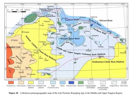
Superposing the above single factor maps and comprehensively analyzing them, especially according to some key isolines, a quantitative lithofacies palaeogeographic map of the Late Permian Wujiaping Age in the Middle and Upper Yangtze Region can be composed (Figure 10).
According to the isoline map of thickness (m)of the Wujiaping Stage (Figure 3), the area with the zero thickness is defined as an eroded area,i.e., the eroded area of Kangdian Land.
According to the isoline map of marine rock content(%)of the Wujiaping Stage (Figure 4), the area with zero content of marine rocks can be defined as land,i.e., Kangdian Land; and the rest is defined as sea.The area between the eroded area and the sea is considered as alluvial plain,i.e., western Sichuan-eastern Yunnan Alluvial Plain.
In the sea, the areas with deep water sedimentary rock content ≥65% are defined as basins according to the isoline map of content (%)of deep water sedimentary rocks (Figure 8).The areas with deep water sedimentary rock content between 35% and 65% are defined as slope(or transision zone); in the other areas of the sea, those with shallow water carbonate rock content ≥50% are defined as carbonate rock platform,i.e., Middle and Upper Yangtze Carbonate Rock Platform, according to the isoline map of shallow water carbonate rock content(%)(Figure 5).The areas with shallow water carbonate rock content <50%, namely, with the shallow water clastic rock content ≥50% (because the contents of the shallow water carbonate rocks and the shallow water clastic rocks have an inverse relationship), are defined as clastic rock platforms,i.e., Sichuan-Guizhou Clastic Rock Platform and Southeastern Clastic Rock Platform.The Sichuan-Guizhou Clastic Rock Platform is located between Kangdian Land and the Middle and Upper Yangtze Carbonate Rock Platform.The Southeastern Clastic Rock Platform is located in the southeastern study area.
In the Middle and Upper Yangtze Carbonate Rock Platform, the areas of the content of biograins with limemud≥30% are defined as biocrows according to the isoline map of content (%)of biograins with limemud (Figure 7).And eight biocrowds are identif i ed.
In the basin, the areas with thin-bedded siliceous rock content ≥50% are defined as siliceous basins according to the isoline map of content (%)of thin-bedded siliceous rocks (Figure 9).The content of thin-bedded siliceous rocks in section 18 is more than 50% in Figure 9.
The quantitative lithofacies palaeogeographic map of the Late Permian Wujiaping Age in the Middle and Upper Yangtze Region (Figure 10)was composed step by step based on the single factor maps studied above.
The palaeogeographic units of this lithofacies palaeogeographic map will be discussed in the following section.
7 Discussions of palaeogeographic units
The main palaeogeographic units distribute from southwest to northeast as follows: Kangdian Land (including Eastern Yunan Eroded Area and Western Sichuan-Eastern Yunnan Alluvial Plain), Sichuan-Guizhou Clastic Rock Platform, Middle and Upper Yangtze Carbonate Rock Platform, Western Hubei Slope, Western Hubei Basin,Northern Slope and Northern Basin.In addition, a transition zone and a basin exist in the area of Wangcang-Nanjiang, and another clastic rock platform developed in the southeastern part of the study area.Several secondary palaeogeographic units, such as biocrowds, also developed in the carbonate rock platform (Figure 10).
7.1 Kangdian Land
There is only one land,i.e., Kangdian Land, which locates in the western part of the study area, and consists of Eastern Yunnan Eroded Area and Western Sichuan-Eastern Yunnan Alluvial Plain.
Eastern Yunnan Eroded Area locates to the west of Zhaojue.This eroded area is small, and its eastern side is the Western Sichuan-Eastern Yunnan Alluvial Plain.
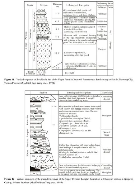
Western Sichuan-Eastern Yunnan Alluvial Plain locates in the area of Yingjing-Leshan-Yanjin-Yiliang-Hezhang-Xuanwei, in a nearly N-S direction and is the main distribution area of the lower part of the Xuanwei Formation.The rock types of this alluvial plain are mainly grey-yellow sandstones, siltstones, mudstones and coal layers.The coal layer is relatively thin (Figure 2a, 2b)or the layer appears as a streak.Sometimes, conglomerates also can be found.Conglomerates were generally the product of braided channels of f l uvial fans and f l uvial-channel lag deposits of meandering rivers.Medium and small cross beddings as well as parallel beddings can be found in sandstones and siltstones.Scour surface structures commonly develop at the bottom of the sandstones.Plant root fossils and siderite nodules can be found frequently in mudstones.The fossils of the alluvial plain are dominated byGigantopterisf l ora;Gigantopteris nicotianaefolia,Gigantonoclea guizhouensis, andUllmanniaare the common types.The alluvial plain mainly consists of alluvial fan deposits(Figure 11)and meandering river deposits (Figure 12).
7.2 Basin
The basins locate in the northern part of the study area,including the Western Hubei Basin and Northern Basin.The two basins are integrated into a single basin, which is mainly composed of thin-bedded siliceous rocks, siliceous shales, and thin- to medium-bedded micritic limestones(Figure 2d, 2f).Lenticular limestones can also be found(Figure 13).The main fossils in the basin are ammonites,small thin-shelled brachiopods and bivalves.Radiolarian and sponge spicules are also common.They form a fossil assemblage of ammonite-radiolarian-sponge spicule.These features ref l ect an oxygen-def i cient or anoxic deep water sedimentary environment.
The content of deep water sedimentary rocks in Wangcang-Nanjiang area in northwestern Sichuan Province may be more than 65%, and the sedimentary environment of this area should be an intra-platform basin referred to as the Wangcang-Nanjiang Basin.
There was a small siliceous basin which was located in the northern part of the study area, namely section 18 in Figure 9.Its main rocks are black thin-bedded siliceous rocks and shales with limestone interbeds.In this area, the content of thin-bedded siliceous rocks is more than 50%,and the content of the deep water sedimentary rocks is more than 65%.

7.3 Slope
The slopes locating along the integrated basin are called the Northern Slope and Western Hubei Slope.The two slopes are integrated into one single slope.Turbidity current deposits are developed in Renshixi, Cili County of Hunan Province.The rocks of this integrated slope are mainly thin- to medium-bedded limestones, siliceous shales and medium- to thick-bedded limestones, thin-bedded siliceous rocks, and mudstones.Generally, the fossils are monotonous, and in low content.
In addition, there is a transition zone in Wangcang-Nanjiang area.In this zone, the content of deep water sedimentary rocks may be between 35% and 65%.Its rock type and fossil assemblage are similar to the slope mentioned above.Given that no gravity f l ow deposits exist, the characteristic of slope is unclear.Thus, it is defined as the Wangcang-Nanjiang Transition Zone.
7.4 Platform
7.4.1Clastic Rock Platform
Two clastic rock platforms of the Wujiaping Age,i.e.,Sichuan-Guizhou Clastic Rock Platform and Southeastern Clastic Rock Platform, locate in the central western and the southeastern study area respectively (Figure 10).Sichuan-Guizhou Clastic Rock Platform locates between the Western Sichuan-Eastern Yunnan Alluvial Plain and the Middle and Upper Yangtze Carbonate Rock Platform.The Southeastern Clastic Rock Platform is adjacent to the Middle and Upper Carbonate Rock Platform.The clastic platform exhibits paralic deposition and is characterized by terrigenous clastic rocks and shallow water carbonate rocks.The content of the clastic rocks is more than 50%and that of the shallow water carbonates is less than 50%(Figure 2d).
The rock types of the clastic rock platforms are mainly terrigenous clastic rocks, including siltstones, mudstones,carbonaceous mudstones, litharenites, coal layers, a small amount of conglomerates, and medium- to thick-bedded limestones.The content of clastic rocks decreases gradually with the increasing content of carbonate rocks.Tidal flat deposits developed in the western clastic rock platform.The tidal flat mainly locates between the mean low water surface and the normal wave base; and a tidal channel develops (Figure 14).A peat bog has also developed in the tidal flat and has created many coal layers.The coal layers mainly distribute in the area of Liupanshui, Weixin and southern Sichuan Province, with a general thickness of 0.2 m to 3 m and thinning eastwards.
Several common fossils, such as roots, stems, leaves of plants, brachiopods, bivalves and gastropods, can be found in the tidal flat deposits.Ichnofossils, mainly skolithos, are also common (Wanget al., 1994).Some delta deposits also exist in this platform,e.g., Zhuzang in Zhijin County of Guizhou Province (Wanget al., 1994).

Given that the clastic rock platform is adjacent to the carbonate platform, these two deposits are often interfin-gered with each other in the vertical direction (Figure 2d).This phenomenon shows that the boundary between these two deposits swings back and forth, and the swing range is wide.This phenomenon also indicates that the platform is fl at.A slight change in terrigenous material supply and sea level would cause the boundary to swing widely.
7.4.2Carbonate Rock Platform
The carbonate rock platform mainly locates in the northwestern, central, and eastern parts of the study area.These parts are integrated into one single carbonate rock platform which is named the Middle and Upper Yangtze Carbonate Rock Platform.And this carbonate rock platform occupies nearly half of the study area.
The Middle and Upper Yangtze Carbonate Rock Platform consists of grey to dark-grey medium- to thickbedded bioclastic limemud limestones as well as minor mudstones, shales, and siliceous rocks.The content of mudstones (or shales)increases towards the Southeastern Clastic Rock Platform, while the content of thin-bedded siliceous rocks increases towards the basin where the content of shallow water carbonate rocks is more than 50%.
7.5 Biocrowd
The term “biocrowd” was proposed by Prof.Zeng-Zhao Feng (Fenget al., 1997).And in 2014, Prof.Feng made a detailed discussion on the meaning of biocrowd(Fenget al., 2014).
The typical biograins in a biocrowd have miscellaneous grain sizes, no erosion phenomena and autochthonous burial (Figure 6).The biograins were formed, deceased,disintegrated, accumulated and buried in the same water body with low energy, and therefore coexisted with limemud.The accumulation of the marine biograins in a stratigraphic unit of an area can not re fl ect the high energy of the water body that these grains experienced.It can only re fl ect that in a certain geological period, this area was favorable for these organisms to live, to breed, and to be preserved (Fenget al., 2014).
In this article, the area with biograin content ≥30% is de fined as a biocrowd.Overall, the content of biograins of the Wujiaping Stage is not high; only eight biocrowds were generated in the carbonate rock platform.
The biograins consist of normal sea narrow salinity creatures, including red algae, green algae, nonfusulinid foraminifers, fusulinids, and brachiopods, and are characterized by foraminifers and algae.Fusulinids are dominated by foraminifers, such asCodonofusiellaandReichelina.Most of them have a thick shell and complex internal structures and are spindle-shaped; the individual size is medium to large.Nonfusulinid foraminifera are dominated byTextulavia;Nodosaria,PadangiaandTetrataxisare common.The algae includeMizzia,Permocalculus,GymnocodiumandEogoniolina.In addition, several biological species coexist with fusulinids and algae, such as corals, brachiopods, bivalves, gastropods, crinoids and bryozoans.
8 Relationship between lithofacies palaeogeography and oil and gas
There are important marine hydrocarbon-bearing strata in the Permian of South China, in which a quantity of hydrocarbon shows and hydrocarbon reservoirs can still be found at present.The hydrocarbon source and reservoir conditions were preliminarily analyzed based on the lithofacies palaeogeography.
8.1 Hydrocarbon source rock conditions
Carbonate rocks, mudstones and coals are recognized as the hydrocarbon source rocks in the Permian of South China.The hydrocarbon source rocks of the Wujiaping Stage in the study area are mainly composed of dark carbonate rocks, thin-bedded siliceous rocks and dark shales of the Wujiaping Formation as well as coals and dark shales of the Longtan Formation.Although the hydrocarbon source rocks of the Wujiaping Stage are various, they exhibit strong heterogeneity (Tengeret al., 2010); thus, the high quality resource rocks are well developed locally.
The content of organic carbon is one of the important parameters in the analysis of hydrocarbon source rocks although some scholars do not believe that it is a good index for measuring the hydrocarbon generating quantity (Dembicki Jr., 2009).The analysis of the hydrocarbon content of 27 samples from the Wujiaping Stage in the study area shows that (1)the hydrocarbon samples in the coastal marsh environment are good-quality resource rocks, whose content is in the range of 3.45% to 70.8%, with a mean value of 29.18%; (2)the content of the hydrocarbon samples in the basin is in the range of 0.71% to 3.21%, with a mean value of 5.37%; and (3)the content of the hydrocarbon samples in the carbonate rock platform is in the range of 0.07% to 11.79%, with a mean value of 1.49%.Three samples have high hydrocarbon content, namely, Jichang section of Xuanhan County in Sichuan Province with 3.30%,Baiyangping section of Jianshi County in Hubei Province with 3.67%, and Xianqiao section of Songzi County in Hubei Province with 11.79%.Eliminating the effect of these three high values, the mean value of the contents of the hydrocarbon samples in the carbonate rock platform is 0.39%.The sequence of the sedimentary environment according to the hydrocarbon content is in order of coastal marsh, basin and carbonate platform.This sequence indicates that the environment does control the development of the hydrocarbon source rock.
Several studies have investigated the hydrocarbon source rock conditions of the thin-bedded siliceous rocks,and show that these rocks have quite high hydrocarbon generation potential (Liet al., 2009; He and Luo, 2010;Luo and He, 2011; Heet al., 2013).The thin-bedded siliceous rocks of the Wujiaping Stage are well developed in the nouthern part of the study area and western Hubei.The content of a sample from the Jingshan area of Hubei is 0.98%.The distribution area, thickness, and hydrocarbon content of the siliceous rocks in the Wujiaping Formation show that these rocks should be good resource rocks.
8.2 Reservoir conditions
Currently, the Wujiaping Formation of Well Yuanba 29 in northwestern Sichuan yields a high gas production of 135.9×10⁴m3per day.This is a major breakthrough in the exploration of the Wujiaping Formation in Yuanba gasfield and ref l ects the good hydrocarbon accumulation condition and exploration potential of the Wujiaping Formatin(Guo, 2011; Guo and Hu, 2011).The palaeogeomorphology formed by Dongwu Movement controls the distribution of lithofacies palaeogeography of the Late Permian in the Middle and Upper Yangtze Region; in the high geomorphology area, the organic banks of the carbonate platform of the Wujiaping Formation are well developed(Guo, 2011).Thus, the relative uplift area in the central part of the Middle and Upper Yangtze Region (Figure 2)is a favorable exploration area of the Wujiaping Formation.
The Upper Permian Longtan Formation in South China is the main coal-bearing stratum, in which the coal bed gas resources are distributed.Coal-bearing formation in the Middle and Upper Yangtze Region mainly develops in the clastic platform near the land (Tianet al., 2010).The Coal and coal bed gas resources are most abundant in eastern Yunnan-western Guizhou-southern Sichuan.Therefore,gas exploration of the Yunnan-Guizhou area should consider coal bed gas as a main target.
Shale gas is a kind of unconventional natural gas that has undergone industrial exploration and development and has become a popular subject in oil and gas geology in recent years (Zhanget al., 2008).Broad, stable mudstones and shales exist in the Wujiaping and the Longtan Formations in the Middle and Upper Yangtze Region.They provide good geological conditions for shale gas accumulation; for example, shale gas showings have been found in the Wujiaping Formation in the western Hubei-eastern Chongqing (Huanget al., 2011).
In conclusion, the Wujiaping Stage in the Middle and Upper Yangtze Region provides favorable conditions for accumulation and has various gas reservoir types.It also has good potential for exploration.
9 Conclusions
The Upper Permian Wujiaping Stage in the Upper and Middle Yangtze Region is well developed and well exposed.It is composed of diverse rock types, including carbonate rocks, clastic rocks, siliceous rocks, pyroclastic rocks, volcanic rocks and coals, with carbonate rocks and clastic rocks as the dominant components.The lithofacies assemblages of the Wujiaping Stage are clastic rock, clastic rock-limestone and limestone-siliceous rock.
The fossils of the Upper Permian Wujiaping Formation in the Middle and Upper Yangtze Region are relatively abundant, and their species are numerous.Palaeontologic research is an important method to sedimentary environment analysis.Four fundamental ecological types, namely,marine benthos, swimming organisms, zooplankton, and terrestrial plants, were identif i ed in the study area.Four fossil assemblages, namely, plant, plant and marine fossil,alga-foraminifer-brachiopod, and ammonite-radiolarian-sponge spicule were established.Each fossil assemblage represents a distinct sedimentary environment.
The lithofacies palaeogeography of the Upper Permian Wujiaping Stage in the Middle and Upper Yangtze Region was studied using the single factor analysis and multifactor comprehensive mapping method.The distribution pattern of palaeogeographic units is regular.The pattern is land (eroded area and alluvial plain), clastic rock platform,carbonate rock platform, slope and basin respectively from west to east.In addition, a clastic rock platform lies in the southeastern study area.Several secondary palaeogeographic units, such as biocrowds, are distinguished in the carbonate rock platform.
Combined with the related geochemical analysis, the hydrocarbon signif i cance of the Upper Permian Wujiaping stage in the Middle and Upper Yangtze Region were preliminarily discussed from the viewpoint of lithofacies palaeogeography.The sedimentary environment has an obvious inf l uence on the development of resource rocks.The hydrocarbon condition in the coastal marsh environ-ment is the best, followed by the basin environment, and the carbonate platform environment is relatively poor.The gas reservoir types of the Wujiaping Stage in the study area are various, such as conventional natural gas and coal bed gas as well as shale gas.All of them have good exploration prospects.
Acknowledgements
This research was supported by the Twelfth Five-Year Plan of major national science and technology project“Study on accumulation conditions and favorable exploration area evaluation of marine carbonate rocks in South China” (2011ZX05004-001-004).We express our sincerest gratitude to Xiang-Dong Li, Dan Wang, Na Liu,Wei-Yang Li, Jing Wen, Xin-Ping Zhou, Hong-Quan Du,Yu Tian, and Hua Li for their help.Professor Zeng-Zhao Feng is specially appreciated for his suggestions during revising the manuscript.Senior Engineers Tian-Sheng Li, Yong-Gang Zhu, Yue-Gang Li and Yin-Ben Zhang of the Sichuan Oilfield Company of PetroChina are also acknowledged.
Chen, H.D., Qin, J.X., Wang, C.S., Shou, J.F., Li, X.H., 1999.Sequence-based lithofacies and paleogeographic characteristics and evolution of Permian in South China.Acta Sedimentologica Sinica, 17(4): 510-521 (in Chinese with English abstract).
Dembicki Jr., H., 2009.Three common source rock evaluation errors made by geologists during prospect or play appraisals.AAPG Bulletin, 93(3): 341-356.
Feng, C.J., Zhang, J.Q., Guan, J.M., 1988.The Upper Permian sedimentary facies in Sichuan Basin and their tectonic controls.Sedimentary Facies and Palaeogeographys, 8(2): 1-15 (in Chinese with English abstract).
Feng, Z.Z., 1977.A new study on lithofacies palaeogeography of the Lower Ordovician in North China.Journal of Oil College of East China, 1(3): 57-79 (in Chinese).
Feng, Z.Z., 1992.Single factor analysis and comprehensive mapping method — Methodology of lithofacies paleogeography.Acta Sedimentologica Sinica, 10(3): 70-77 (in Chinese with English abstract).
Feng, Z.Z., 2004.Single factor analysis and multifactor comprehensive mapping method — Reconstruction of quantitative lithofacies palaeogeography.Journal of Palaeogeography (Chinese Edition), 6(1): 3-19 (in Chinese with English abstract).
Feng, Z.Z., 2009.Definition, content, characteristics and bright spots of palaeogeography of China.Journal of Palaeogeography (Chinese Edition), 11(1): 1-11 (in Chinese with English abstract).
Feng, Z.Z., He, Y.B., Wu, S.H., 1993.Lithofacies palaeogeography of Permian Middle and Lower Yangtze Region.Acta Sedimentologica Sinica, 11(3): 13-24 (in Chinese with English abstract).
Feng, Z.Z., Yang, Y.Q., Jin, Z.K., Li, S.W., Bao, Z.D., 1997.Lithofacies palaeogeography of Permian of South China.Dongying: Petroleum University Press, 1-242 (in Chinese with English preface, contents and abstract).
Feng, Z.Z., Zheng, X.J., Bao, Z.D., Jin, Z.K., Wu, S.H., He, Y.B.,Peng, Y.M., Yang, Y.Q., Zhang, J.Q., Zhang, Y.S., 2014.Quantitative lithofacies palaeogeography.Journal of Palaeogeography,3(1): 1-34.
Flügel, E., 2004.Microfacies of Carbonate Rocks: Analysis, Interpretation and Application.Berlin: Springer, 53-70.
Guo, T.L., 2011.Basic characteristics of deep reef — Bank reservoirs and major controlling factors of gas pools in the Yuanba Gas Field.Natural Gas Industry, 31(10): 12-16; 114 (in Chinese with English abstract).
Guo, X.S., Hu, D.F., 2011.Newest progress and key techniques in gas exploration of reef — Bank reservoirs in the northeastern Sichuan Basin.Natural Gas Industry, 31(10): 6-11; 113-114 (in Chinese with English abstract).
He, Q.X., Ye, Z.Z., Zhang, M.S., 1990.Late Permian sedimentation in Sichuan Basin and analysis based on comparative sedimentology.Marine Geology and Quaternary Geology, 10(2): 1-12 (in Chinese with English abstract).
He, Y.B., Luo, J.X., 2010.Lithofacies palaeogeography of the Late Permian Changxing Age in Middle and Upper Yangtze Region.Journal of Palaeography (Chinese Edition), 12(5): 497-514 (in Chinese with English abstract).
He, Y.B., Luo, J.X., Wen, Z., 2013.Lithofacies palaeogeography of the Upper Permian Changxing Stage in the Middle and Upper Yangtze Region, China.Journal of Palaeogeography, 2(2): 139-162.
Hu, M.Y., Wei, G.Q., Hu, Z.G., Yang, W., Hu, J.Z., Liu, M.C., Wu,L.Q., Xiang, J., 2010.Sequence-lithofacies palaeogeography of the Middle Permian Qixia Formation in Sichuan Basin.Journal of Palaeography (Chinese Edition), 12(5): 515-526 (in Chinese with English abstract).
Huang, Q., Shi, Y.H., Ye, Y.G., Liu, W.J., Ge, H., 2011.The drilling characteristics and potential analysis on fractured shale fas in Wujiaping Formation of eastern Chongqing-western Hubei area.Journal of Oil and Gas Technology, 33(2): 108-110 (in Chinese with English abstract).
Li, G.H., Li, X., Song, S.J., Song, W.H., Yang, X.N., 2005.Dividing Permian into 3 series and its signif i cance in Sichuan Basin.Natural Gas Exploration and Development, 28(3): 20-25 (in Chinese with English abstract).
Li, H.J., Xie, X.N., Lin, Z.L., Yan, J.X., Zhou, L., Xiong, X.,Su, M., 2009.Organic matter enrichment of Dalong Formation in Guangyuan area of the Sichuan Basin.Geological Science and Technology Information, 28(2): 98-103 (in Chinese with English abstract).
Li, S.S., Liu, D.C., 1988.The Late Permian sedimentary environment and organic reefs in Sichuan Basin.Acta Sedimentologica Sinica, 6(3): 112-117 (in Chinese with English abstract).
Liu, B.J., Xu, X.S., 1994.Atlas of Lithofacies Paleogeography in South China (Sinian to Triassic).Beijing: Science Press, 1-188(in Chinese).
Luo, J.X., He, Y.B., 2011.Anoxic environments of the Permian of Middle and Upper Yangtze Area.Journal of Palaeogeography (Chinese Edition), 13(1): 11-20 (in Chinese with English abstract).
Luo, J.X., He, Y.B., Wang, D., Li, W.Y., Wen, J., 2013.Petrological characteristics and sedimentary environment analysis of the Permian of Songkan Section, Tongzi County, Guizhou Province.Science and Technology Review, 31(2): 37-44 (in Chinese with English abstract).
Luo, J.X., He, Y.B., Wang, D., Zhou, X.P., Tian, Y., Liu, N., Li, H.,2009.Petrological characteristics and sedimentary environment analysis of the Permian of Daxiakou section, Xingshan County,Hubei Province.Journal of Palaeogeography (Chinese Edition),11(4): 393-404 (in Chinese with English abstract).
Ma, L., Chen, H.J., Gan, K.W., Xu, K.D., Xu, X.S., Wu, G.Y., Ye,Z., Liang, X., Wu, S.H., Qiu, Y.Y., Zhang, P.L., Ge, P.P., 2004.Tectonic and Marine Petroleum Geology of South China (Volume 1).Beijing: Geological Publishing House, 3-8 (in Chinese).
Ma, Y.S., Chen, H.D., Wang, G.L., Guo, T.L., Tian, J.C., Liu, W.J.,Xu, X.S., Zheng, R.C., Mou, C.L., Hou, M.C., 2009.Sequence Stratigraphy and Paleogeography in Soutn China.Beijing: Science Press, 1-603 (in Chinese).
Ma, Y.S., Guo, X.S., Guo, T.L., Huang, R., Cai, X.Y., Li, G.X.,2005a.Discovery of the large-scale Puguang gas field in the Sichuan Basin and its enlightenment for hydrocarbon prospecting.Geological Review, 51(4): 477-480 (in Chinese with English abstract).
Ma, Y.S., Mu, C.L., Guo, T.L., Tan, Q.Y., Yu, Q., 2005b.Sequence stratigraphy and reservoir distribution of the Changxing Formation in northeastern Sichuan Basin.Earth Science Frontiers,12(3): 179-185 (in Chinese with English abstract).
Ma, Y.S., Mu, C.L., Guo, X.S., Tan, Q.Y., Yu, Q., 2006.Characteristic and framework of the Changxingian sedimentation in the northeastern Sichuan Basin.Geological Review, 52(1): 25-29(in Chinese with English abstract).
Mou, C.L., Tan, Q.Y., Yu, Q., Wang, L.Q., Wang, R.H., 2004.The organic reefs and their reef-forming model for the Upper Permian Changxing Formation in northeastern Sichuan.Sedimentary Geology and Tethyan Geology, 24(3): 65-71 (in Chinese with English abstract).
Mou, C.L., Xu, X.S., Lin, M., 1992.Sequence stratigraphy and complication of lithofacies and palaeographical maps: An example from the Devonian strata in southern China.Sedimentary Facies and Palaeogeography, 12(4): 1-9 (in Chinese with English abstract).
Tenger, Qin, J.Z., Fu, X.Z., Yang, Y.F., Xie, X.M., 2010.Hydrocarbon source rocks evaluation of the Upper Permian Wujiaping Formation in northeastern Sichuan area.Journal of Palaeography,12(3): 334-345 (in Chinese with English abstract).
Tian, J.C., Chen, H.D., Tan, J.X., Hou, Z.J., Hou, M.C., Peng, J.,2004.Case study of sequence-based lithofacies-paleogeography research and mapping of South China.Journal of Earth Sciences and Environment, 26(1): 6-12 (in Chinese with English abstract).
Tian, Y., Zhang, X.Y., He, Y.B., Luo, J.X., Zhou, H., Zhou, X.P.,Du, H.Q., 2010.Lithofacies palaeogeography of the Late Permian Wujiaping Age of Sichuan Basin.Journal of Palaeography(Chinese Edition), 12(2): 164-176 (in Chinese with English abstract).
Wang, C.M., Wang, C.L., Liu, C.L., Long, S.X., Wu, S.X., Zhang,J.T., 2011.Sedimentary facies, sedimentary model and evolution of Changxing Formation in northeast Sichuan Basin.Geology in China, 38(3): 594-609 (in Chinese with English abstract).
Wang, L.T., Lu, Y.B., Zhao, S.J., Luo, J.H., 1994.Mineralization and Lithofacies Palaeogeography of Permian in South China.Beijing: Geological Publishing House, 1-147 (in Chinese).
Yang, G.R., Zhang, Y.C., Huang, Y.A., Li, C.L., Wang, X.H., 1986.The Coal Character and Division of the Upper Permian in southern Sichuan.Chongqing: Chongqing Press, 1-153 (in Chinese).
Zhang, J.C., Wang, Z.Y., Nie, H.K., Xu, B., Deng, F.Y., Zhang, P.X., Yin, Y., Guo, H.Q., Lin, T., Zhang, Q., Zhang, D.M., 2008.Shale gas and its signif i cance for exploration.Geoscience, 22(4):640-646 (in Chinese with English abstract).
杂志排行
Journal of Palaeogeography的其它文章
- Reply to Shanmugam, G.“Review of research in internal-wave and internal-tide deposits of China:Discussion”
- Review of molar tooth structure research
- Review of research in internal-wave and internal-tide deposits of China: Discussion
- Armoured mud balls as a result of ephemeral fluvial flood in a humid climate: Modern example from Guizhou Province, South China
- Reply to Shanmugam, G. “Review of research in internal-wave and internal-tide deposits of China:Discussion”
- Summary of the Editorial Committee Meeting of Journal of Palaeogeography in Geneva, at the 19th International Sedimentological Congress (ISC)