Distribution of arsenic in sediment of Hangjinhou Banner- Linhe transect in Hetao Basin, North China
2014-08-09CAOWen-geng,CHENNan-xiang,ZHANGYi-long等
Abstract: In this research, we laid a Hangjinhou Banner-Linhe District drilling transect along western piedmont of Hetao Basin to the modern Yellow River, which passes through the Langshan Mountain piedmont alluvial-proluvial fan, the Yellow River paleochannel, alluvial-fluvial plain of the Yellow River and the modern Yellow River flood plain successively and based on which we collected sedimentary samples of different geomorphic units. Based on hydrogeology and sedimentology and by means of stratum tracing and transects comparison, the analysis result comes out that the arsenic (As) sediments in Hetao Basin is distributed in obvious zoning form and is closely related to the sedimentary environment. The paleochannel zone in northern Basin has the highest content of As sediments, average content reaching 12.24 μg/g. In the horizontal direction of the profile, the distribution regularity of As is consistent to that of elements like Mn, Fe, Al and TOC, since they have experienced the same geochemical process in sediments. In the vertical direction, the high-arsenic sediments are mainly formed of grey black silty-fine sand layers or interbedding layers of silty-fine sand and muddy clay, rich in organic matter. The sedimentary environments are mainly shallow lakes and depressions, where the content of As is related to that of elements like Sb, Mn, B, V, etc., and particularly has significant relation with Fe.
Keywords: As; Sediments; Hetao Basin; Paleochannel
Introduction
The Hetao Plain in Inner Mongolia of China is a sagging sedimentary basin. The Yellow River flowed into the broad Hetao Plain through the Ningxia-Mongolia narrow valley, a series of alluvial-proluvial sediments of super thickness having deposited there during a long period of geological history (LI Bing-yuan, 2003). Due to the high-arsenic problems of the native groundwater found in large area, this area has attracted attention from experts and scholars home and abroad (YANG Jie and LIN Feng-nian, 1996; WANG Yan-xinet al. 2001; Berg Met al. 2001; GUO H Met al. 2008; DENG Ya-min, 2008; GAO Cun-ronget al. 2010; CAO Wen-genget al. 2010; GUO Hua-minget al. 2010; DENG Ya-minet al. 2011; ZHANG Yi-longet al. 2013). Most scholars hold the view that the As is originally adsorbed to the sedimentary particles, then due to the reducing of FeOx·(OH)3-2xwhich is distributed in diffusion form and contains rich As elements, the adsorbed As is released in groundwater (R Nicksonet al. 2000; McArthur J Met al. 2001; Bhattacharya Pet al. 2003; Harvey C Fet al. 2002; DENG Ya-minet al. 2011; GUO Het al. 2014). The dissolved organic matter, as the carbon source for microbial metabolism, can promote and accelerate the biogeochemical process of As in the groundwater system (GUO H Met al. 2008). The Hetao Basin in Inner Mongolia, affected by the diversion of the Yellow River, presents extremely complicated landform and sedimentary environments; and the distribution regularity of As in the sediments has close relation with the geological landform and hydrodynamic conditions (ZHENG Yan, 2010). Therefore, finding out the distribution regularity of As in different geomorphic units of the Hetao Basin may be conducive to finding out the cause of formation of the high-arsenic groundwater in Hetao Basin and getting knowledge of the geochemical process. Based on the above ideas and previous research results, we have collected sedimentary samples of different geomorphic units by setting the “Hangjinhou Banner-Linhe drilling transect” stretching from the western piedmont of the Hetao Basin to the Yellow River. By analyzing the sedimentary samples, we tried to find out: (1) the distribution regularity of As in the sediments in the area stretching from the piedmont to the Yellow River; (2) major factors that affect the enrichment of As in the sediments in different geomorphic units. By doing this, we are going to enrich the theoretical system of high-arsenic water formation mechanism and thus provide basis for As control and water improvement in the Hetao Basin.
1 Geological and hydrogeological characteristic
1.1 Geology and stratigraphy
The Hetao Basin is located in the western Inner Mongolia Autonomous Region, adjacent to the Yinshan Mountains to the north, Erdos Plateau to the south, and Ulan Buh Desert to the west. This basin is a closed arc-shaped long-time sagging fault basin, forming an asymmetric dustpan-shaped depression which is deep in the north and west and shallow in the south and east in terms of tectonic form. The depression formed since Cenozoic is particularly deep. The depth of the basement depression and the tectonic occurrence are affected by three groups of east-west, north-west and north- west faults, forming two uplift zones and four depression zones, which can be classified into 6 tectonic units of Class IV from east to west: Sanhu riverbed valley-shaped shallow depression zone, Xishanzui latent Wulashan Mountain uplift zone, Ulansuhai Lake shallow depression zone, Shanba deep depression zone, Ulan Buh basement slope shallow depression zone, Dengkou fault block uplift zone; and the faults are taken as the control boundary. The depth of the basement depression is increasing gradually from southeast to northwest, increasing from 500-1 500 m in Urad Front Banner to 7 000-8 000 m in northern Shanba. The northwestern basin of Shanba, located in the area where the latitudinal tectonic system meets the Neocathaysian tectonic system, is the deepest adoptive depression of this area.
1.2 Hydrogeology
The recharge, runoff, and discharge characteristics of the Hetao Plain are mainly affected by integrated factors including landform, earth’s surface lithology, diversion irrigation and groundwater exploitationetc.
The target stratum of this paper is shallow groundwater. In the alluvial-lacustrine plain area along the Yellow River, shallow groundwater of the Hetao Basin mainly runs from the north bank of the Yellow River to the northern piedmont, in southwest-northeast direction. In the plain area with flat terrain and small hydraulic slope, where the aquifer is formed of fine particles with permeability coefficient lower than 20 m/d, the groundwater flows slowly consequently.
Except for the piedmont alluvial-proluvial fan of the Yinshan Mountains where the water table is 10-30 m, other shallow groundwater in the basin is buried very shallowly at 1-3 m, while the annual evaporation of this area is extremely high up to 2 050-2 550 mm. Additionally, the aeration zone of the Houtao Plain is formed of sandy soil and sandy clay with fine particles and weak capillarity. As a result, shallow groundwater evaporates intensively and evaporation becomes the major discharge way for shallow groundwater in the plain area. During the agricultural irrigation seasons when the water table of shallow groundwater rises, groundwater will drain into the ditch and then run into the general drainage ditch via ditches of different levels. The recession flow will enter Ulansuhai Lake via the drainage ditch and then back into the Yellow River via the Ulansuhai Lake waste canal. In addition, the Houtao Plain contains a large area of agricultural land where the evaporation of crops that consume groundwater during the growth period is also one of the discharge routes for shallow groundwater.
2 Sampling and analysis
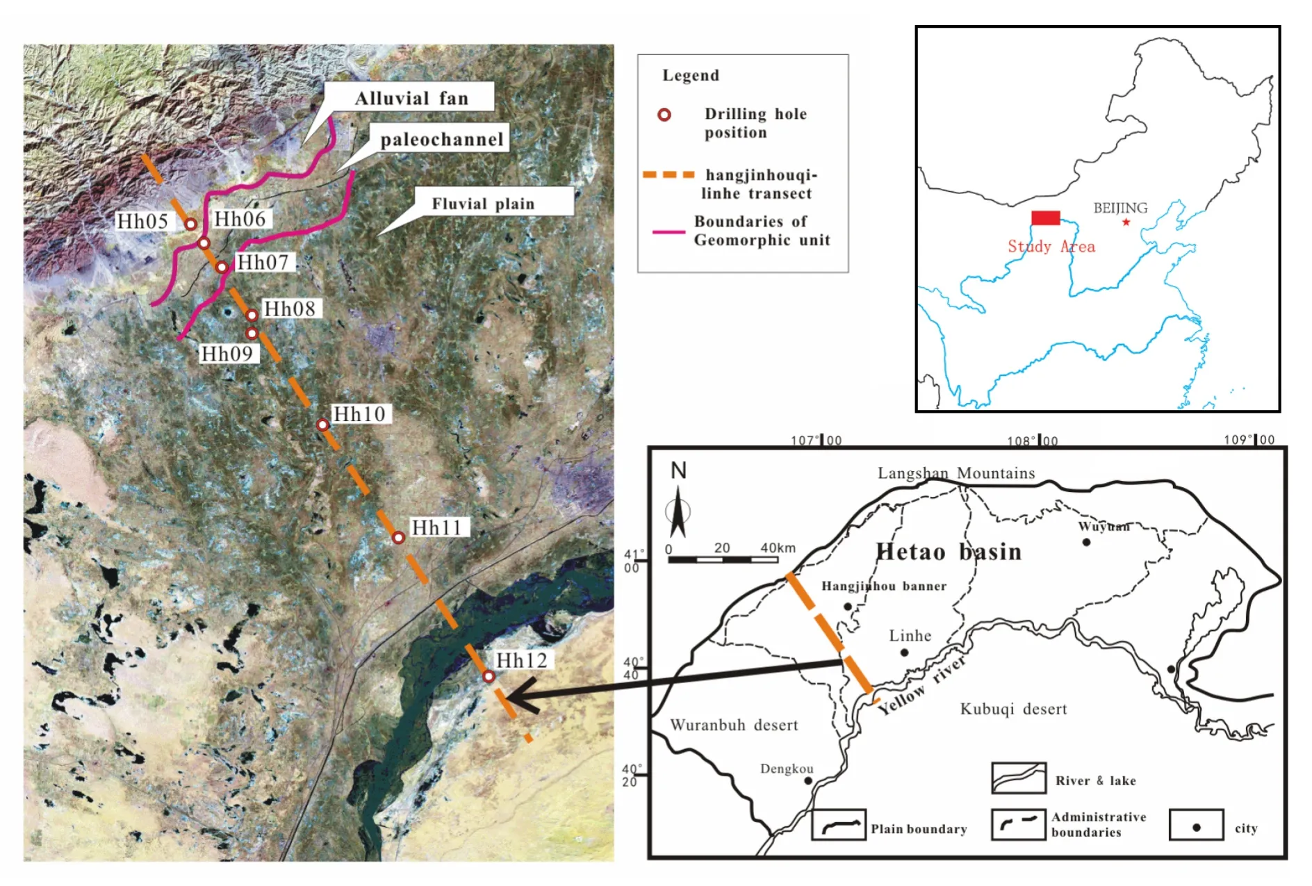
In order to explore the distribution characteristics and occurrence modes of As in sediments, eight environmental geological drilling groups were set in the western Hetao Basin of Hangjinhou Banner and Linhe District from July to September in 2010. The 8 drilling bores were laid from north to south, numbered HH05-HH12, passing through the piedmont alluvial-proluvial fan of Langshan Mountain, the paleochannel of the Yellow River, the alluvial lacustrine plain of the Yellow River and the flood plain of the modern Yellow River, with drilling depth at about 50 m. Representative rock and soil samples at different depths were collected for lab analysis (The sampling intervals are usually no wider than 1 m and may be even narrower when the lithology changes). The transect position and drilling position of the Hangjinhou Banner-Linhe drilling bores are shown in Fig. 1.

Fig. 1 Sampling sites of sediment in Hetao Basin
The mineral composition of sediment can be determined with the X-ray Power Diffraction (XRD), major chemical composition can be determined with the X-ray fluorescence spectrum (XRF), the total C, total N, and total S in sediment can be determined with the elemental analyzer, and the granularity can be measured with the laser granularity analyzer. For the determination of As in sediment, we can use Aquaregia Water Bath for digestion and then test it with HG-AFS. For the determination of other microelements in sediment, we can adopt the standard method (HCl+HNO3+ HF+HClO4) issued by SEPA for mixed-acid digestion and then test with ICP-AES and ICP-MS.
3 Results and discussion
We have conducted a complete analytical test on the cores of 8 drilling bores (No. HH05-No. HH12) on the “Hangjinhou Banner-Linhe drilling transect”, having analyzed their respective content of 24 kinds of elements including As, Fe, F, TOC, Cl, Mn,etc., in sediments at different depth. And detailed analysis on the correlation between As and other elements have been carried out particularly.
3.1 General characteristics
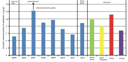
Fig. 2 indicates that the content of As in the stratum is not high, with average content in the transect reaching 5.2-12.24 μg/g, among which the bore HH07 has the highest average content reaching 12.24 μg/g. It is recorded in the Inner Mongolia Hetao Agricultural Economic Zone Multi-target Geochemical Survey prepared by Inner Mongolia Geological Survey Institute and Arsenic in the Environment by Nanjing Institute of Geography & Limnology of CAS that the average content of As is 9.73 μg/g in the stratum of Hetao Plain, 8.05 μg/g in the stratum of Inner Mongolia Autonomous Region, 11.2 μg/g in the stratum of the overall China and 6.7 μg/g globally (Fig. 2). As shown in the transect, only the average content of As in bore HH07 in the Yellow River paleochannel of the central alluvial lacustrine plain of the Yellow River and bore HH09 in the central basin are higher than the average value of the Hetao Plain. The average values of As in bore HH08 in the central part of the plain and of bore HH12 in the Yellow River flood plain come near the average value of Hetao Plain. The average value of As in bore HH05 in the piedmont alluvial-proluvial fan and in bore HH11 in the basin edge is lower than that in Hetao Plain. Comparing with the average value of As in the overall Inner Mongolia, the respective average contents of As in bore HH07, HH08, HH09 and HH10 are higher.

Fig. 2 Arsenic concentration of HH05-HH12 transect in the research area of Hangjinhou Banner (Data source: Inner Mongolia Hetao Agricultural Economic Zone Multi-target Geochemical Survey prepared by Inner Mongolia Geological Survey Institute and Arsenic in the Environment by Nanjing Institute of Geography & limnology of CAS)
The average content of As in sediment of Hetao Basin shows obvious zoning features and is closely related to sedimentary environment. The average As content in the piedmont alluvial-proluvial fan sediment is only 5.20 μg/g, being the lowest value of the overall transect, also lower than the average value of the Hetao Plain, Inner Mongolia Autonomous Region, China and the world. The leading-edge depression of the piedmont fan of the Yinshan Mountain in north basin is the region with the lowest terrain in this area and is also the subsidence center of the Hetao Basin, located along the general drainage ditch, where the aquifer is mainly formed of grey and grey-black silty-fine sands and grey-black sandy loam and the stratum sedimentary environment is shallow lacustrine depression sediment, with average As concentration at 12.24 μg/g, much higher than the average value of the Hetao Plain, Inner Mongolia Autonomous Region, China and the world. The content of As in the HH05-HH12 transect tends to decline from the general drainage area in the northern basin to the basin edge but shows an uprush in bore HH12 in the Yellow River flood plain (Fig. 2).
3.2 Horizontal distribution characterristics of As in sediment in “Hangjinhou Banner-Linhe” transect
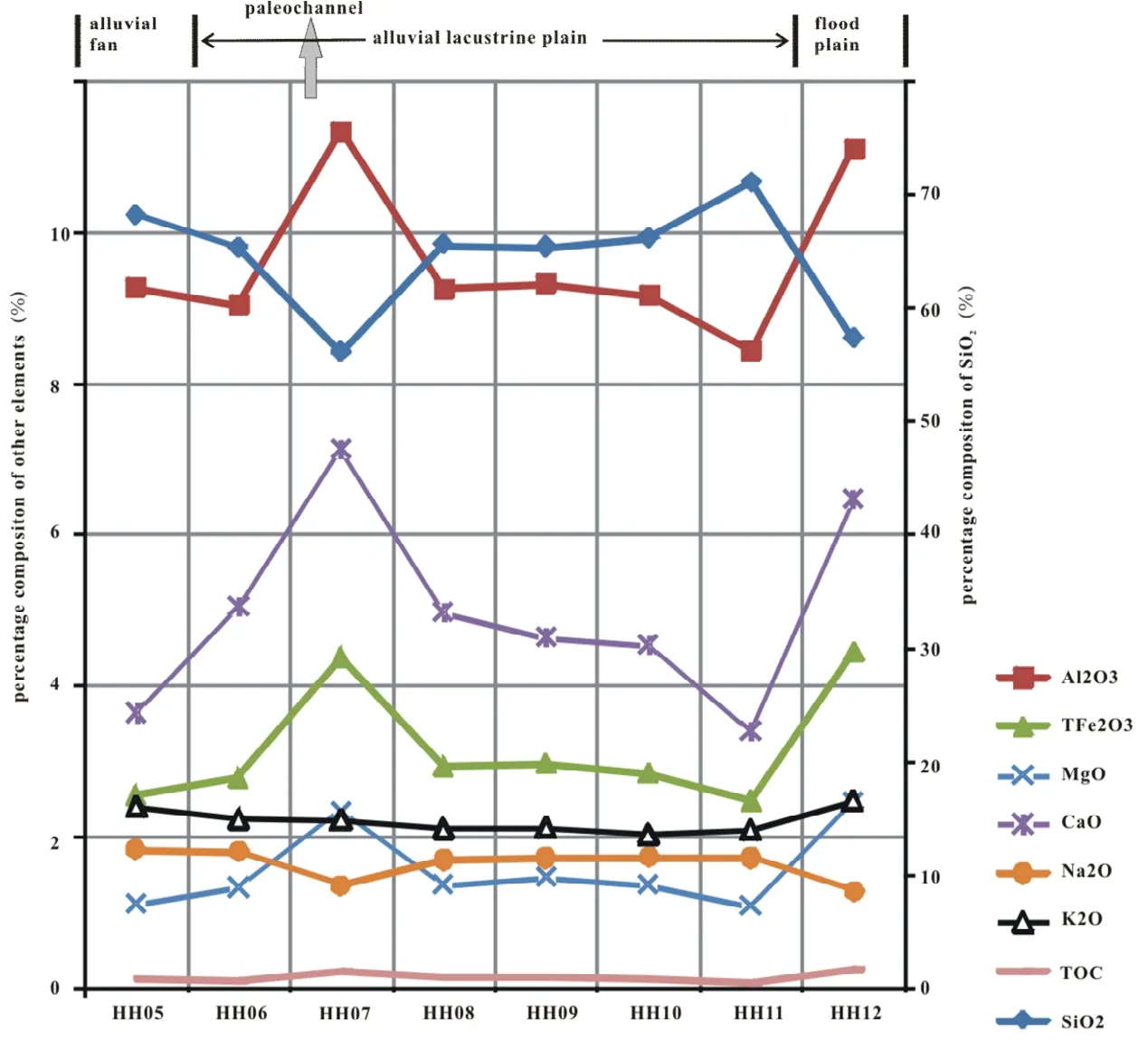
Based on the position of each boring, we draw the content curve of elements in “Hangjinhou Banner-Linhe” HH05-HH12 transect (Fig. 3 and Fig. 4). From the content curve of elements, we found that SiO2has the highest content, followed by Al, Fe, Ca, K, Na, Mn, P,etc. successively. Most of the curves show similar trend to that of As, showing two troughs and two peaks.

Fig. 3 Distribution curve of average concentration of As and other elements in bores HH05-HH12 in western Hetao Basin (1)

Fig. 4 Distribution curve of average concentration of As and other elements in bores HH05-HH12 in western Hetao Basin (2)
The elements that have similar curve to As include Mn, Fe, Al, Ca, Mg, P, F, Cl, V, B, Ni, Sb, Zn, Cu, TOC,etc. These elements show a strong correlation with As, indicating that they have consistent variation tendency. That’s to say, As and these elements in sediments have experienced the similar geochemical process or they share the same origins.
As and Fe, Mn, Al:
According to the statistics of the element analysis results of the 241 groups of sedimentary samples collected from 8 bores, As has an extremely high correlation with Fe, Mn and Al in content, with correlation coefficient reaching at least 0.9 (which between As and Fe even reaching up to 0.96 particularly), which indicates that As is adsorbed by Fe, Mn and Al in the sediments as stated in the previous studies (GUO H Met al. 2008; DENG Ya-min, 2008). Due to the neutral and alkalescence of the groundwater in the Hetao Basin as the pH value (at about 8.0) indicates, the arsenate and arsenite are easier to be adsorbed by the positively charged substance (e g. oxide of Fe and Mn, goethite, pyrite, hematite, gibbsite, ferrihydrite,etc.) in the water-bearing media or by ferric hydroxide colloid in the aquifer, so as to form indissolvable precipitates attaching to the sediments with fine particles.
As and Na, Ca, Mg, Cl:
Na, Ca, Mg and Cl are the major positive ions and negative ions in groundwater, which are also distributed in obvious zoning form in the sediments of the Hetao Basin. The content of Ca, Mg and Cl rises in the Yellow River paleochannel area in north of the basin (in bore HH07) where is the subsidence center of the Yellow River alluvial- lacustrine plain. The Quaternary sediment has the highest thickness and lowest terrain in the overall area and is the area where groundwater gathers. The evaporation in this area is strong and the content of Cl reaches the peak value here which can also indicate that here is the final collecting point of groundwater runoffs. Meanwhile, the content of Ca and Mg reaches the peak value in the paleochannel zone while the content of Na down to the lowest point of the transect, which indicate that the alternative adsorption of positive ions has occurred in the Yellow River paleochannel zone: the Na in the original sediments being replaced by Ca and Mg into water and Ca and Mg enriching in the sediments. As a result, the Na in the transect shows a contrary distribution pattern to that of As, Ca, Mg and Cl: reaching the lowest value in the paleochannel zone and modern flood plain of the Yellow River as shown in the transect.
As and P:
As and P are congeners, showing very similar chemical behavior in the groundwater system. The competitive adsorption existing between As (V) and P will cause influence on the fixation and activation of As in sediments inevitably, especially in the clay mineral where P will restrain the adsorption of As (V) in sediments continuously. With the thickening of P, the adsorption amount of As (V) tends to decrease gradually (ZHANG Xian-wei, 2009; LIN Liu, 2011). As shown in Fig. 3, As and P in the sediment transect show basically consistent distribution regularity: both reaching the peak value in the Yellow River paleochannel in north of the Yellow River alluvial-lacustrine plain (bore HH07). Additionally, the content of P in different geomorphic units is higher than that of As obviously. Thus, in the coexisting system of P and As, the adsorption of As is inhibited by P significantly.
As and SiO2:
The content curve of SiO2is completely opposite to that of As. Where the As has the highest content SiO2has the lowest. Generally, SiO2in quartz and feldspar of sand layer has relatively high content while in clay mineral has low content. Therefore, the distribution of SiO2reflects the regularity of clay-sand ratio in the stratum indirectly and thus verifies the point that the enrichment of As is directly related to the distribution of clayey soil in the stratum.
As and TOC:
The latest research indicates that the degradable organic carbon in the high-arsenic aquifer is mainly sourced from the organic matter in the natural sedimentary stratum, which can facilitate the microorganism reduction and dissolution of As and Fe (Mladenov Net al. 2010). As a result, the content of total organic carbon (TOC) is important for facilitating the migration and release of As in sediments. As shown in Fig. 4, the content of TOC and As shows a basically consistent trend. The statistic result based on 241 groups of samples show that the correlation efficient between TOC and As reaches 0.91 and both TOC and As reach the peak value in the Yellow River paleochannel zone and modern flood plain as shown in the transect.
As and other heavy metal elements:
Generally, little Hg and Pb exist in the stratum, except for the artificially polluted area where the content is relatively high. As shown in the transect, little Hg exists in the area stretching from the piedmont alluvial-proluvial fan to the Yellow River alluvial-lacustrine plain, but the content of Hg and Pb is abnormally high in the Yellow River flood plain of bore HH12 where is largely affected by the Yellow River and human disturbance. Thus we conclude that the Hg and Pb in the stratum are enriched due to the pollution of the Yellow River.
3.3 Vertical distribution characteristics of As in sediments
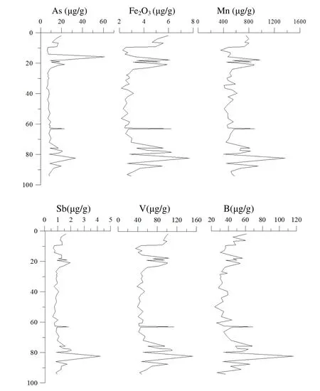
The bore HH07 has the highest average content of As in sediments among the transect HH05- HH12. This bore is located in the Shahai Town near the general drainage of Hangjinhou Banner, where the terrain is low and belongs to depression-phase sediments. The vertical distribution regularity of As in sediments of bore HH07 shows that in the area of depth at 10 m, 20 m, 25 m and 28 m the As concentration is observed increasing significantly. The sediments are grayish brown clay and loam with grayish black silt and silty-fine sand interbeded. The As-enriched sediments are generally grayish silty-fine sand layers or interbed of silty-fine sand and muddy clay, rich in organic matter. The sedimentary environment is the shallow lacustrine depression environment. And the layer for people to take water from with a pressure well is also at the depth. As a result, the shallow lacustrine depression type sedimentary environment in the Hetao Plain is one of the causes of the abnormal content of As in groundwater.
As shown in Fig. 5, the relation between the As and other elements in sediments indicates that the distribution of content of As has a significant correlation with that of Sb, Fe, Mn, B, V,etc., vertically, with correlation coefficient reaching up 0.9. In the As-enriched slay layer or loam layer, the content of Sb, Fe, Mn, V and B is also relatively high correspondingly. These elements show consistent variation tendencies, indicating that As, Sb, B and V in sediments are affected by the same geochemical process or they share the same source. All these elements can be adsorbed by the oxide of Fe and Mn. The obvious correlation between As and Fe indicates that the As has a close relation with the Fe2O3in sediments.

Fig. 5 Vertical distribution of As, Fe2O3, Mn, Sb, B and V in sediments of bore HH07 in Hangjinhou Banner
4 Conclusions
The distribution of As in sediments of Hetao Plain shows obvious zoning feature and is closely related to the sedimentary environment. Located in the Yellow River paleochannel zone in the western Hetao Basin, the aquifer is mainly formed of grey and grayish black silty-fine sand with black sandy loam. The sedimentary environment of the stratum is shallow lacustrine depression type. The average content of As is 12.24 μg/g, higher than that in other geomorphic units, the Inner Mongolia region, China and the world. The piedmont alluvial fan and the Yellow River alluvial-lacustrine plain in the central Hetao Basin have low content of As in sediments. The content of As in the transect HH05-HH12 tends to decrease gradually from the general drainage area in the northern Hetao Basin to the basin edge, but shows an uprush at bore HH12 in the Yellow River flood plain.
In horizontal direction, in the Hangjinhou Banner-Linhe transect, the distribution regularities of As in different geomorphic units show a consistent variation tendency with that of Mn, Fe, Al, Ca, Mg, P, F, Cl, V, B, Ni, Sb, Zn, Cu and TOC. These elements have strong correlation with As. These elements and As in sediments are affected by the same geochemical process and share the same source.
In vertical direction, the As-enriched sediments are mainly formed of grayish black silty-fan sand or interbed of silty-fine sand, clay and muddy clay, with rich organic matter. The sedimentary environment is shallow lacustrine depression type, which is one of the major causes of the abnormal content of As in groundwater. The content of As in sediments is related to elements like Sb, Mn, B, V, and particularly Fe.
Acknowledgements
Youth science fund project of natural science foundation of China “Control mechanism on the distribution of high-arsenic groundwater by the sedimentary microfacies of the Yellow River Flood Fan since Late Pleistocene” (No. 41402234).
