A permafrost factor in the development of deformations on the Amur Highway
2014-07-06DorofeevLitovko
Dorofeev I.V.,Litovko A.V.
(Melnikov Permafrost Institute SB RAS,Yakutsk 677010,Russia)
0 Introduction
The federal highway P-297 Amur from Chita to Khabarovsk with a length of 2165 km was put into operation in 2010.The general direction of the road from west to east of the country determined its latitudinal and sublatitudinal direction in the Transbaikal Territory,the Amur region,the Jewish Autonomous and Khabarovsk Krai(region)(Fig.1).The Amur Highway traverses areas with non-uniform geological,geomorphological,hydrological and climatic conditions,due to which the engineering geological conditions are highly complicated.
A wide range of engineering-geological conditions and their modern dynamics is typical for the territory due to the fact that the road traverses the southern part of the permafrost.The permafrost within the Transbaikal territory and the western part of the Amur region is continuous,discontinuous or insular.A long distance of the road's western part in the Amur region,Jewish Autonomous Area and Khabarovsk Krai traverses mainly areas of patchy permafrost and deep seasonal freezing.
First data concerning the conditions of linear objects in the territory were obtained during the construction of the Trans-Siberian Railway at the beginning of the 20thcentury.The most important data concerning the temperature and seasonal thawing of the permafrost were obtained at the Skovorodino Permafrost Station[1].
Detailed analysis of the permafrost in this area was provided by[2]in relation to the construction of the Baikal– Amur Mainline(BAM).Specific information concerning the engineering-geological conditions along the Amur Highway route was obtained during design and survey works and research investigations conducted by Soyuzdorproekt,Irkutskgiprodornii,Khabarovsk branch of“GIPRODORNII”,TranIGEM,Lomonosov Moscow State University and other organizations.
Kondratyev and Soboleva[3]developed the concept of engineering geocryological monitoring of the Amur Chita-Khabarovsk Highway,based on the analysis of reconnaissance investigation data and first years of operation of the Amur Highway sections,as well as on research materials of TranIGEM.For the first time in Russia,a system of engineering geocryological monitoring(constant control,estimation and forecast of dangerous phenomena,development of technical measures to ensure the stability of the road surface)was offered for the road constructed in complicated climatic and geotechnical conditions.
In 2012~2013,the Melnikov Permafrost Institute conducted a study to identify the causes of deformations on the Amur Highway,as part of“Investigation and Estimation of the Р-297 Amur Chita-Khabarovsk Highway in The Transbaikal Territory and the Amur Region”research project.For this purpose,an engineering geocryological monitoring was organized,the results of which are presented in this paper.
1 Materials and methods
Studying the natural-technical system of the Amur Federal Highway(hereinafter referred to as NTS of the“Amur”)was carried out by means of engineering geocryological monitoring.The main methodological guidelines in the study were the following works:(Methods of Geocryological Survey[4],Pavlov[5],Konstantinov[6]and the Regulations[7].
The engineering geocryological experimental research was organized in areas where the deformations were the most significant.The NTS of the“Amur”was studied in 18 major segments-areas.The research in the monitoring segments was conducted using the same methods.The research program included the following types of work:
-surveillance along the key sections of the road covering cross profiles 50 m to the left and right of the road,including permafrost landscape description,maximum thaw depth measurements,and determination of soil texture in the seasonally thawed layer(STL);
-radioimpedance sounding to identify the areas with highest ice contents(at drilling stage);
-drilling to 11.5 m depth with soil sampling for determination of physical and mechanical properties;
-instrumentation of boreholes and measurements of the active layer and permafrost temperatures(every 10 days in the first month after drilling and then every three months);
-determination of soil physical and mechanical properties using the Litvinov field laboratory and in the laboratory.
2 Results and discussion
The research in key areas identified the existence of ice-rich permafrost which contain wedge,intrusive and pore ice beneath the roadway(the ice complex)(Fig.4).The ice-complex thickness within some areas directly beneath the road reaches 10.5 m.During the construction and first years of operation(3 to 5 years),the ice-rich ground has thawed to a depth of 1.3~4.2 m beneath the road embankment.Drilling showed that the thawed layer(technogenic suprapermafrost talik)was highly saturated(Fig.5).The intensity of permafrost technogenic degradation during the first years of road operation was 26 ~140 cm per year,averaging 73 cm per year.In 2013 ground thawing beneath the embankment decreased to 14~35 cm per year due to the climatic conditions of the year and due to the natural attenuation of the cryogenic process.
The thickness of taliks depends on embankment height,composition and ice content of underlying soils.The analysis of data showed that maximum deformations due to the cryogenic factor were registered on the road sections with embankment height of up to 3~4 m.
On road sections with higher embankment,deformations develop due to simultaneous effect of the following factors:water accumulation on the roadway due to improper drainage,piping of fine material from the embankment,melting of ground ice,etc.An example is a damaged road section at 781 km,where the embankment height is 7~8 m.Water passage thorough the embankment on the left side of the road forming an alluvial fan,which consists of sandy silt,sand and fine gravel,is obvious.There is a technogenic lake on the right side of the road along the embankment,which,in our opinion,is a thermokarst one.The length of the lake is 27~30 m,and its depth is 0.7~0.9 m.The lower part of two water pipes is at the lake's level.Some amounts of water pass through the embankment.
Large cracks and some deformations due to differential embankment settlement appear especially active on the roadway sections underlain by ice-rich permafrost(Fig.2~3).Such areas are most common on gentle north-facing slopes covered with waterlogged deciduous woodlands.
The cross profiles show an asymmetry in the configuration of technogenic taliks.This is often related to differences in aspects of embankments and their slopes(Fig.6).The length of water-saturated zones beneath the road on such sections is determined by the ice-complex boundaries.Groundwater discharge from linear technogenic taliks usually occurs in low-lying areas,i.e.at culverts and bridges.Thus,we have registered places of groundwater discharge at the road embankment base at the left-bank bridge abutment(890 km,the Urusha River).Numerous groundwater seeps were found on both sides of the road.During road inspection in early September 2007,the total discharge rate of the seeps was approximately 1 ~3 L/s.
In undisturbed areas along the road route,minimum thaw depths are 0.6~0.8 m and maximum thaw depths are 1.9~2.4 m or more.The mean annual ground temperature at a depth of 10 m in the investigated part of the road varies from 4.4 to-1.2℃;the lowest values occur in middle-height mountains in southern Transbaikalia.
Data on composition and thickness of the active layer,as well as on ground temperature in the cryolithogenic complexes not affected by road construction,and their comparison with data reported in the published and unpublished literature indicate that under natural conditions they have remained almost unchanged during at least the last 50 ~60 years.
According to the results of regional geocryological investigations conducted during recent decades,the drained watersheds and south-facing slopes may be most commonly affected by permafrost degradation.Thus,under natural conditions of South Yakutia,ground temperature in the layer of annual heat ex-change on dry mountain tops and slopes tends to increase due to the climate change.Metamorphic rocks with low water content and high thermal conductivity are typical for slopes and tops of the central part of the Aldan-Timpton interfluve area.Long-term investigations indicate that the increase in ground temperature at a depth of 15~20 m was 0.3~1.2℃;this corresponds to the current increase in air temperature in this region[7].As a result,permafrost with the thickness up to 20 m has partially degraded during the last 30~50 years in such areas.The permafrost response to modern climate changes in ice-rich biogenic and mineral soils of the valleys and intermountain areas is not significant(from several dozens of centimeters to first few meters).
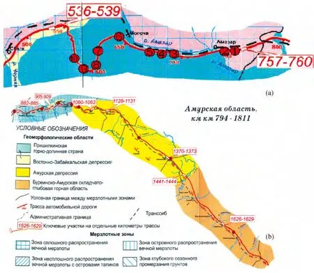
Fig.1 Map showing the location of key monitoring sites on the Amur Highway:
Thus,the degradation situation under natural conditions in the south of Eastern Siberia and in the Amur region is exaggerated to a considerable degree by some scientists and mass media.At the same time,taking into account high mean annual permafrost temperature(0 to-1.5℃,the most common values are-0.3 to-0.5℃)degradation processes in the permafrost zone can be significant.As mentioned above,during 3~5 years of the Amur Highway construction and operation,seasonal thaw depth in the ice-rich permafrost areas has increased by more than 4 m under the roadway compared to the undisturbed terrain.
A thaw bulb was formed as a result of technogenic degradation beneath the embankment.Just 3 years after,residual thaw layers were found at the time of maximum freezing at the base of technogenic taliks.
3 Conclusions
1)Significant changes have occurred in the lithological substrate of the“Amur Highway during the construction and first years of operation,deteriorating the roadway performance.The main cause of road deformations in the permafrost areas is the increase in thaw depth of ice-rich soils and ground ice bodies beneath the road,resulting in the formation of water-saturated suprapermafrost taliks of varying configuration and thickness.

Fig.2 Main types of roadway deformations in permafrost areas:

Fig.3 The cause(a)and the effect(b)of ice-rich permafrost degradation:
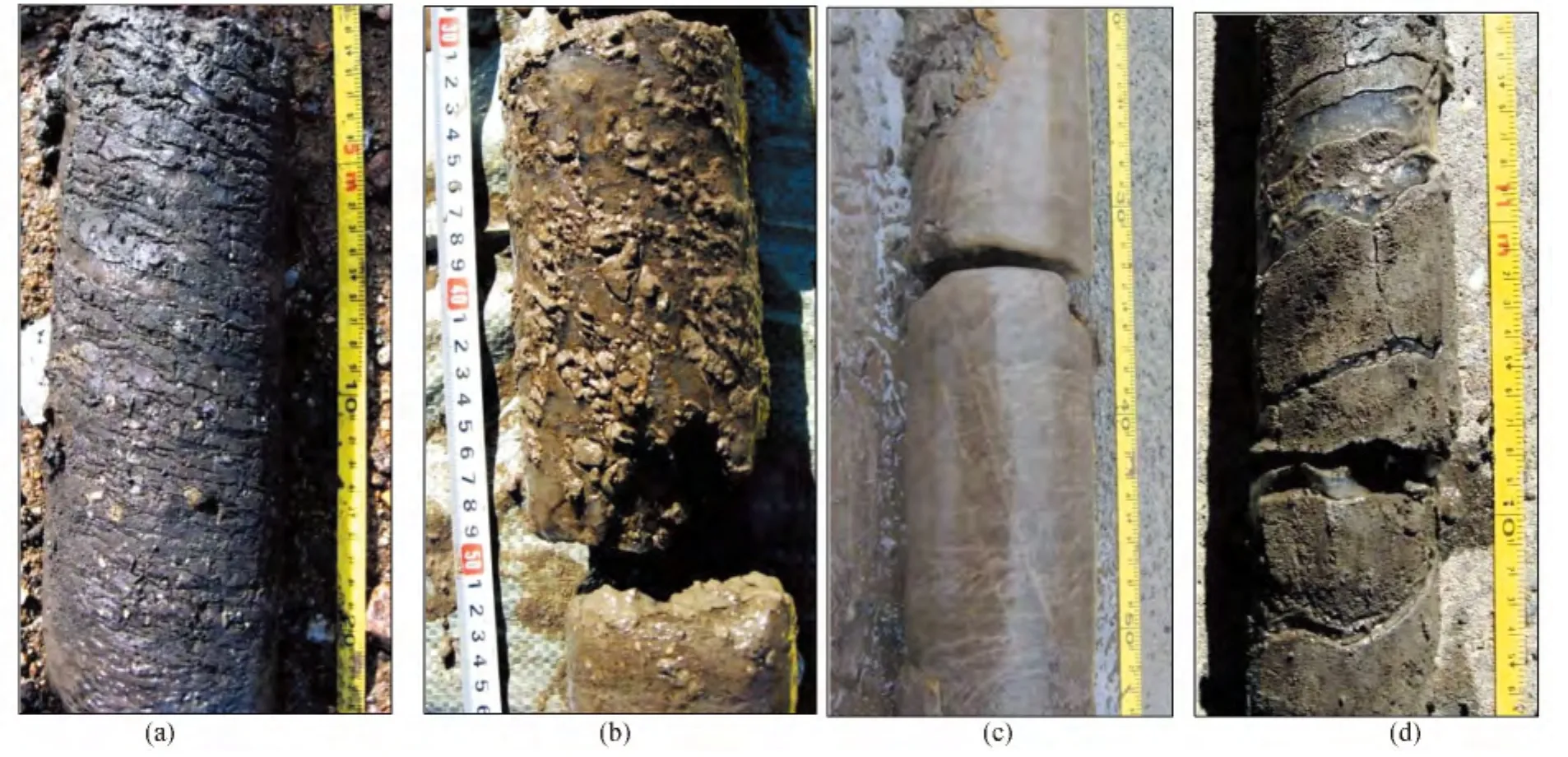
Fig.4 Ground ice in the foundation soils of the Amur Highway:

Fig.5 Engineering geocryological monitoring of the section 1(km 531 of the“Amur”highway)
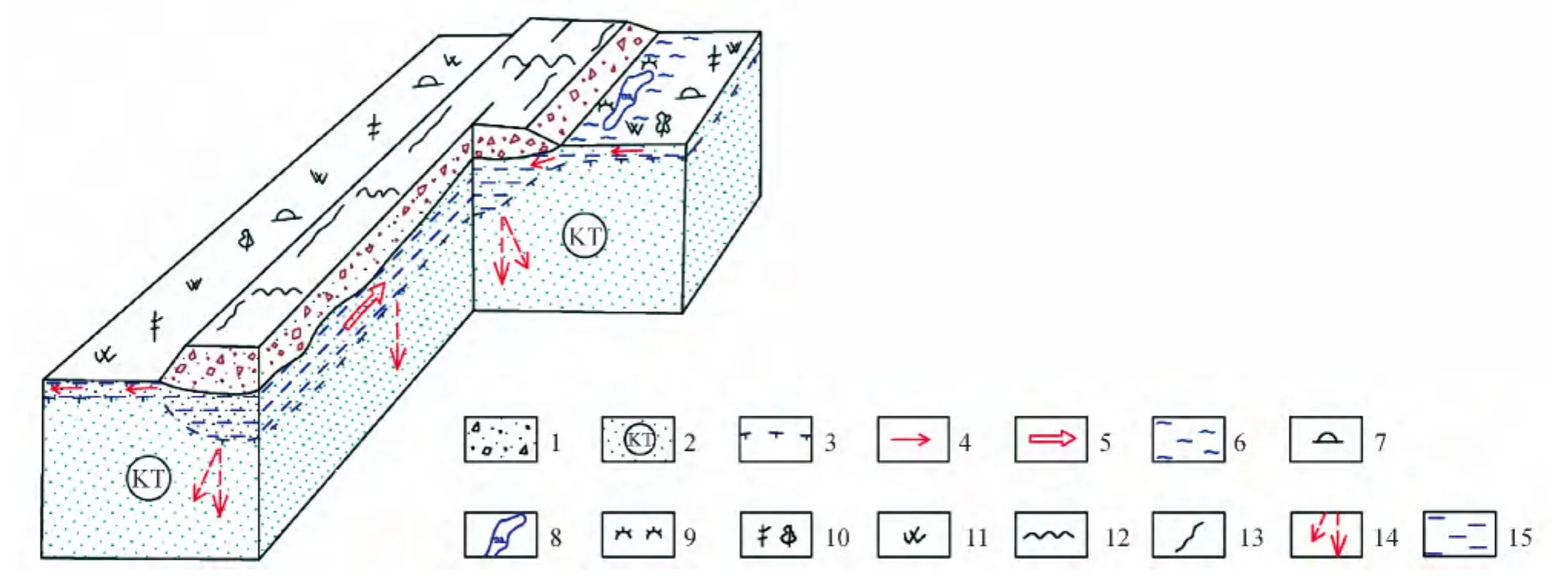
Fig.6 Scheme of formation and functioning of the talik zone and deformations of the road surface in the areas of permafrost development along the Amur Highway
2)Frost heave and subsequent thaw subsidence occur as the road foundation proceeds from the state of disequilibrium to quasi-equilibrium.The process of their formation can last for at least 8~10 years if the road technical load and rate of climate change are increased.
3)Materials concerning the composition,thickness of the seasonally thawed layer and the temperature of cryolithogenic complexes,which were not affected by the construction and their comparative analysis with data from literature sources make it possible to state that under natural conditions these complexes have remained almost unchanged during recent 50 ~60 years.The degradation situation under natural conditions in the south of Eastern Siberia and in the Amur region is exaggerated to a considerable degree by some scientists and mass media.At the same time,taking into account high mean annualpermafrosttemperature(0…-1.5℃,the most common values are-0.3 to-0.5℃)degradation processes in the permafrost zone can be significant.
[1]Kapterev P N.About the soil thermal regime in Skovorodino/P.N.Kapterev//Proceedings of the permafrost commission[J].Moscow-Leningrad:Academy of Sciences of the USSR Press,1938.(6):127-153.
[2]Nekrasov I A,Klimovskiy I V.Permafrost of the BAM[M].I.A.Nekrasov.-Novosibirsk:Nauka,1978,120-124.
[3]Kondratiev V G.,Soboleva S V.The concept of engineering-geocryological monitoring system of the“Amur”Chita-Kha-barovsk highway[M].Chita:Zabtrans,2010 ,176-179.
[4]Kondratiev V G.Methods of geocryological survey[M].Moscow:Moscow University Press,1979:358-362.
[5]Pavlov A V.Cryolithozone monitoring[M].Novosibirsk:Academic Publishing House“Geo”,2008,229-234.
[6]Konstantinov P Y.The methods of observation areas organization for permafrost monitoring(scientific handbook)[M].Yakutsk:Permafrost Institute SB RAS Press,2009,68-75.
[7]Dorofeev I V.Geocryological conditions in the eastern part of the Aldan iron ore province Dorofeev I V[J].Geography and Regional Studies in Yakutia.North-Eastern Federal University Press,2011,155-159.
杂志排行
黑龙江大学工程学报的其它文章
- The harm of perennial frozen soil to the pipeline exporting the crude oil from Mohe county to Daqing city
- Overview of research methods of frozen soil hydrology in Heilongjiang Province
- Environmental geochemistry of urban areas in Yakutia
- The problem of project statement of construction principles of buildings and facilities in permafrost
- The forecast of a temperature regime of soils containing the pile foundation of a pithead on diamond-mining mines of cryolithic zone
- Industrial and residential construction on hydraulic fill in permafrost regions:problems and prospects