Evaluation of the Overall Level of New Urbanization in Hebei Province Based on Factor Analysis and GIS
2014-04-10ShuqinZHAOXuemengSHYunfanNIU
Shuqin ZHAO,Xuem eng SH I,Yunfan NIU
Graduate College,Shijiazhuang University of Economics,Shijiazhuang 050031,China
1 Introduction
The18th National Congress of the Communist Party of China clearly proposed the concept of"new urbanization".The Central Economic Work Conference further listed"speeding up the pace of urbanization"as one of six tasks of economic work in 2013.The report of the Eighth Party Congress in Hebei Province pointed out that accelerating the process of new urbanization is a major strategic choice for Hebei Province to build a economically strong and harmonious province[1].
The so-called new urbanization refers to a process of urban development,guided by the scientific development concept,and driven by the new industrialization,aimed at pursuing rational structure,high efficiency,perfect function,environment-friendliness,social harmony and integration of urban and rural areas[1].The new urbanization should not be merely the"population urbanization",and high rate of urbanization rate(urban population/total population),but the urbanization of industry,population,land,society and rural areas.
In view of this,when evaluating the level of urbanization in 11 prefecture-level cities of Hebei Province,we first consider the situation of the relevant natural and social factors in the province,to select the 9 indicators that can comprehensively reflect the development of urbanization.Using the SPSS software,we perform the factor analysis to get the score of the overall level of urbanization in the cities of Hebei Province,and then use GIS to put the score as the single factor layer to overlay the municipal administrative layers for analysis,to generate the thematic map based on the score of the overall level of urbanization,thereby revealing the spatial pattern of new urbanization level in the whole province.In the evaluation,the indicators selected cover population,society,ecology,land and other aspects;the display of evaluation results is under the aid of GIS software,and the whole process reflects the connotation of new urbanization evaluation.
2 Overview of the study area
Hebei Province is located in the northern part of the North China Plain,with a total area of 187700 km2.As of the end of 2011,there were33 cities in the province,including11 district-level cities and 22 county-level cities[2];there were 114 counties,1013 towns,and 946 townships,with a total population of 72.41 million,and the urbanization rate reached 45.6%[3].
Since the reform and opening up,the level of urbanization in Hebei Province has showed an increasing trend,from 12.56%in 1978 to 45.6%in 2011,and the province has gradually formed a perfect urban system consisting of provincial central cities,regional central cities,small and medium-sized cities,counties and towns.
However,compared with the national average(51.27%),the level of urbanization development in Hebei Province lags behind,so improving the level of urbanization has become one of the main tasks of current urban-rural coordination in Hebei Province.
3 Data sources
The data are from the direct or indirect statistics of Hebei provincial administrative map,thematic maps and Hebei Statistical Yearbook(2012)[4].The research platform is built based on dedicated geographic information system software(ArcGIS 9.3)and multivariate statistical software SPSS.
4 Research methods and content
In this paper,we select factor analysis method to analyze the over-all level of new urbanization in Hebei Province.The calculated score of overall level is regarded as a layer to be superimposed on the administrative map of Hebei Province,and GIS visualization technology,data management and spatial analysis methods are used to generate the thematic map based on the score of the overall level of urbanization,thereby revealing the spatial pattern of new urbanization level in the whole province.This data processing technology road map based on factor analysis method and GIS can be seen in Fig.1.
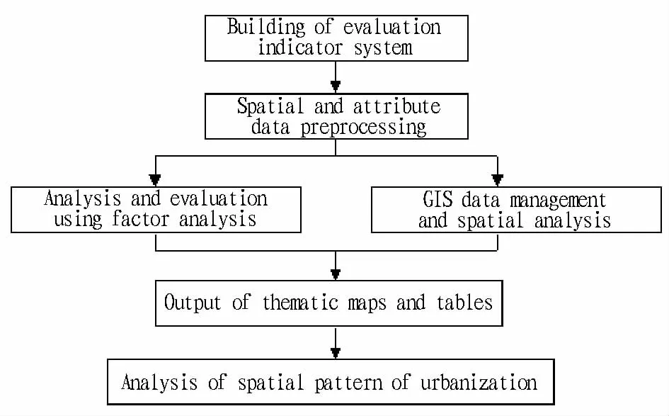
Fig.1 The data processing technology roadmap
4.1 Evaluation of the overall level of urbanization in Hebei Province based on factor analysis Currently,the commonly used methods for the evaluation of urbanization include AHP,Delphi method and factor analysis.The first two methods have different degrees of subjectivity,possibly leading to the missing of the original information[5].Factor analysis is a statistical method used to describe variability among observed,correlated variables in terms of a potentially lower number of unobserved variables called factors,and it is more objective.Factor analysis searches for such joint variations in response to unobserved latent variables.The observed variables are modelled as linear combinations of the potential factors,plus"error"terms.The information gained about the interdependencies between observed variables can be used later to reduce the set of variables in a dataset.Computationally this technique is equivalent to low rank approximation of the matrix of observed variables.Factor analysis originated in psychometrics,and is used in behavioral sciences,social sciences,marketing,product management,operations research,and other applied sciences that deal with large quantities of data.Specific methods are as follows:
4.1.1 Selection of indicators.In the context of increasingly prominent contradiction between economic development and resources&environment,there is a need to pay more attention to the content and quality of urbanization,overcome the extensive urbanization tendency,and choose the new urbanization road suitable for each city[6].
Therefore,taking the objective,scientific and comprehensive evaluation as the starting point,this paper draws on the existing integrated indicator system measurement results,and follows the principles of systematicity,completeness,validity,scientificity and operability,to select 9 indicators as the evaluation factors from the connotation of new urbanization(Table 1),so as to measure the overall level of urbanization in the cities of Hebei Province.
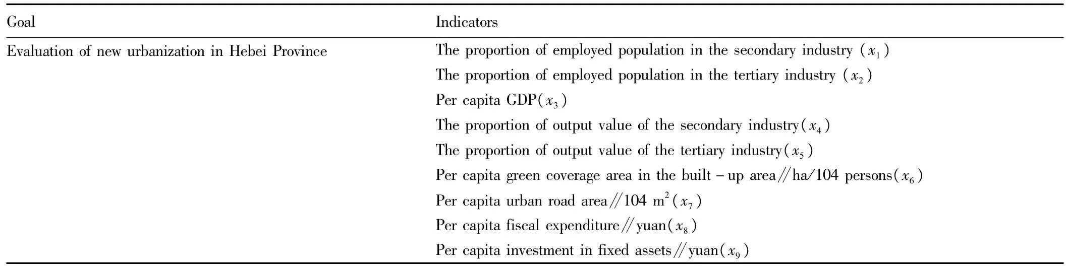
Table 1 Indicators for measuring the overall level of urbanization
4.1.2 Extraction of the principal factors.In this study,we take the indicators for 11 cities in Hebei Province as the samples,and use the standardized data of9 indicators as variables to build matrix.The data are processed using SPSS 19[7].
First of all,we perform the suitability test of the sample data,and it is found that the significance level of correlation coefficient test(chi-square value)is0.000<0.0001,that is,the correlation matrix is not an identity matrix,and there is correlation between the variables,indicating that the data in this study are suitable for factor analysis.
Through the characteristic root of matrix and the corresponding variance contribution rate,we select the principal component and get the factor extraction results and factor regression coefficients.According to the principle of characteristic root>1,the principal component is selected.
Based on the calculation results using SPSS software,we choose the first three characteristic roots as the principal components(Table 2),and the cumulative variance contribution rate reaches86.601%,basically retaining the original indicator information,so we can choose the first three characteristic roots to build the initial factor loading matrix(Table 3).
4.1.3 Rotated factor extraction.Given that the initial factor extraction results can not clearly reflect the indicator information contained in the principal component,the orthogonal varimax rota-tion is performed,and the rotated factor extraction results and factor regression coefficients are shown in Table 4.
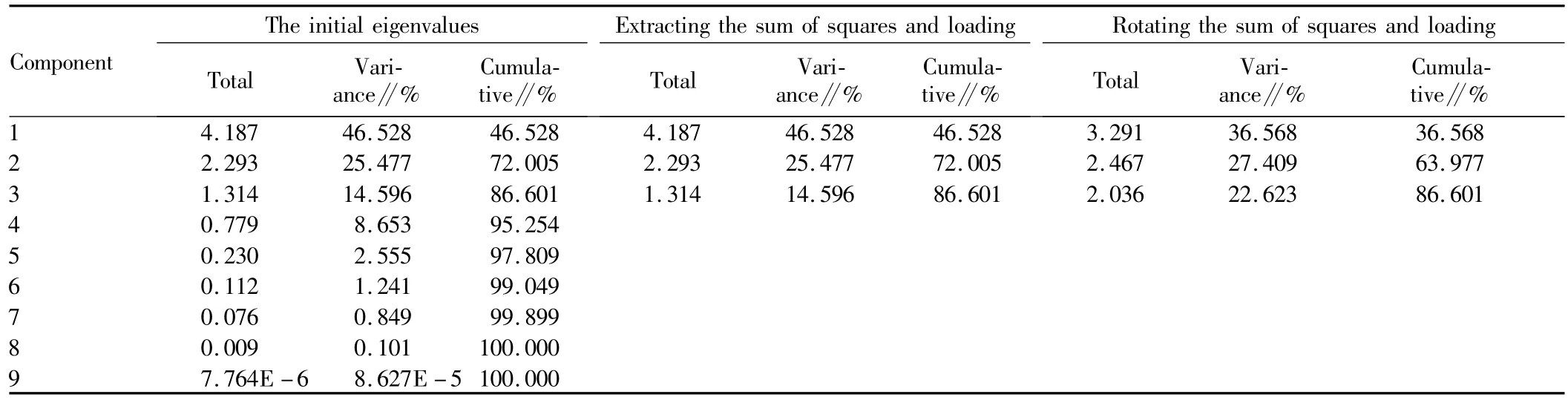
Table2 Total variance decomposition table
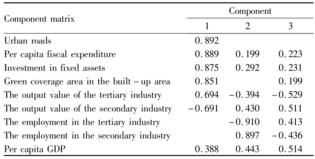
Table 3 The initial factor loading matrix
4.1.4 Naming of factor variables.By Table 4,the principal components are determined as follows:
(i)The first principal component has large absolute load factor on x3,x6,x7,x8,and x9,so it can be defined as the social urbanization factor;
(ii)The second principal component corresponds mainly to x4,and x5,so it can be defined as the economic urbanization factor;
(iii)The third principal component has large absolute load factor on x1,and x2,so it can be defined as the population urbanization factor.
4.1.5 Calculation of the composite score and ranking.With the variance contribution rate of selected principal factors as the weight,the scores of various factors are integrated,to derive the composite index of each sample Fi.The formula is as follows:
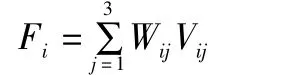
where Fiis the composite score of principal factor of city i;Wijisthe load of city ion principal factor j;Vijis the variance contribution rate of principal factor j selected by city i.
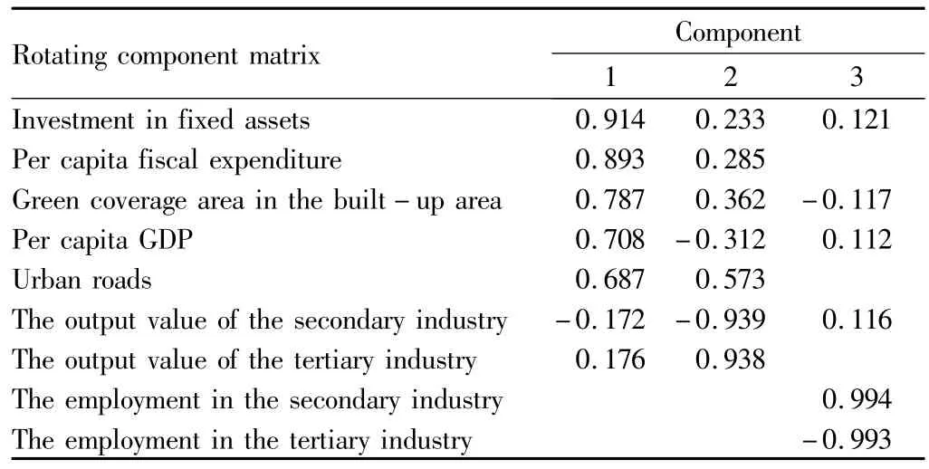
Table 4 Rotated factor loading matrix
Thus we get the ranking of11 prefecture-level cities in Hebei Province based on the common factor score,as is shown in Table 6.
Three common factors reflect the level of urbanization in the cities of Hebei Province from different aspects,but a common factor alone can not make a comprehensive evaluation of the status of cities in the province,so the composite score F is calculated with the variance contribution rate that common factors correspond to as the weight:

whereλiis the eigenvalue of the common factors.
The score of overall level of urbanization and ranking of the cities in Hebei Province is shown in Table 7.
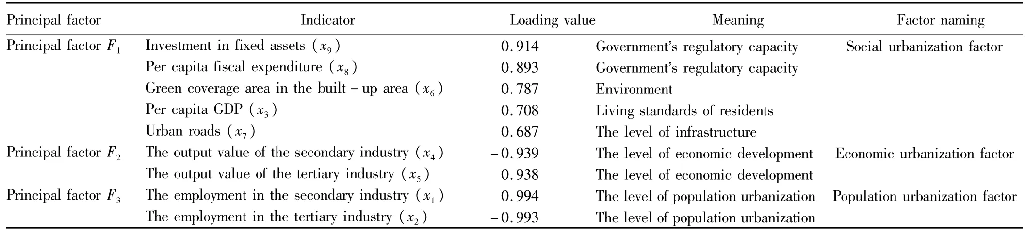
Table5 Principal factor loading
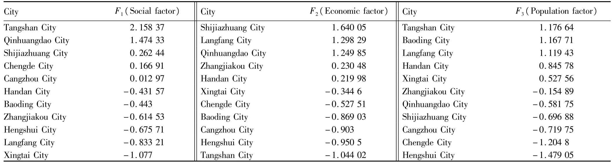
Table6 The ranking of the cities in Hebei Province based on the common factor score
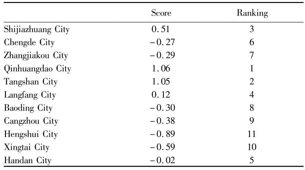
Table 7 The score of overall level of urbanization and ranking
4.2 The spatial pattern distribution of urbanization in Hebei Province based on GIS From the above analysis,we get the composite score of the level of urbanization of the cities in Hebei Province.In order to facilitate the analysis of the driving forces and judge whether the results are related to the spatial pattern distribution of the cities,this paper uses ArcGIS software to put the scores as the single factor layer to be superimposed on the administrative map of Hebei Province,to generate the thematic map based on the score of the overall level of urbanization.Here we use GIS visualization technology,data management and spatial analysis.
4.2.1 Visualization technology.The basic meaning of GIS visualization is to visually and vividly express and interactively process a lot of abstract or invisible data generated in scientific computing in the form of graphics image information,using the geometric figure,color,texture,transparency,contrast,animation techniques and other means[8].
MacEachren uses geographic visualization to describe the functions of maps in the context of the visual information processing[9].Using the spatial visualization of GIS,we can visually understand the spatial distribution of data.
4.2.2 GIS data management and spatial analysis.GIS data not only include spatial data,but also include attribute data,and the attribute data are associated by ID number and spatial data.In this paper,we intend to make thematic maps based on attributes,so we first add the scores of three common factors and total scores to the attribute table of11 cities in Hebei Province,respectively,and input the corresponding data to the corresponding attribute table.
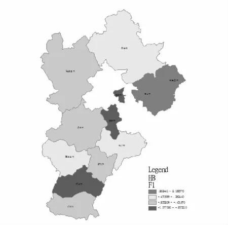
Fig.2 F1 factor regional distribution map
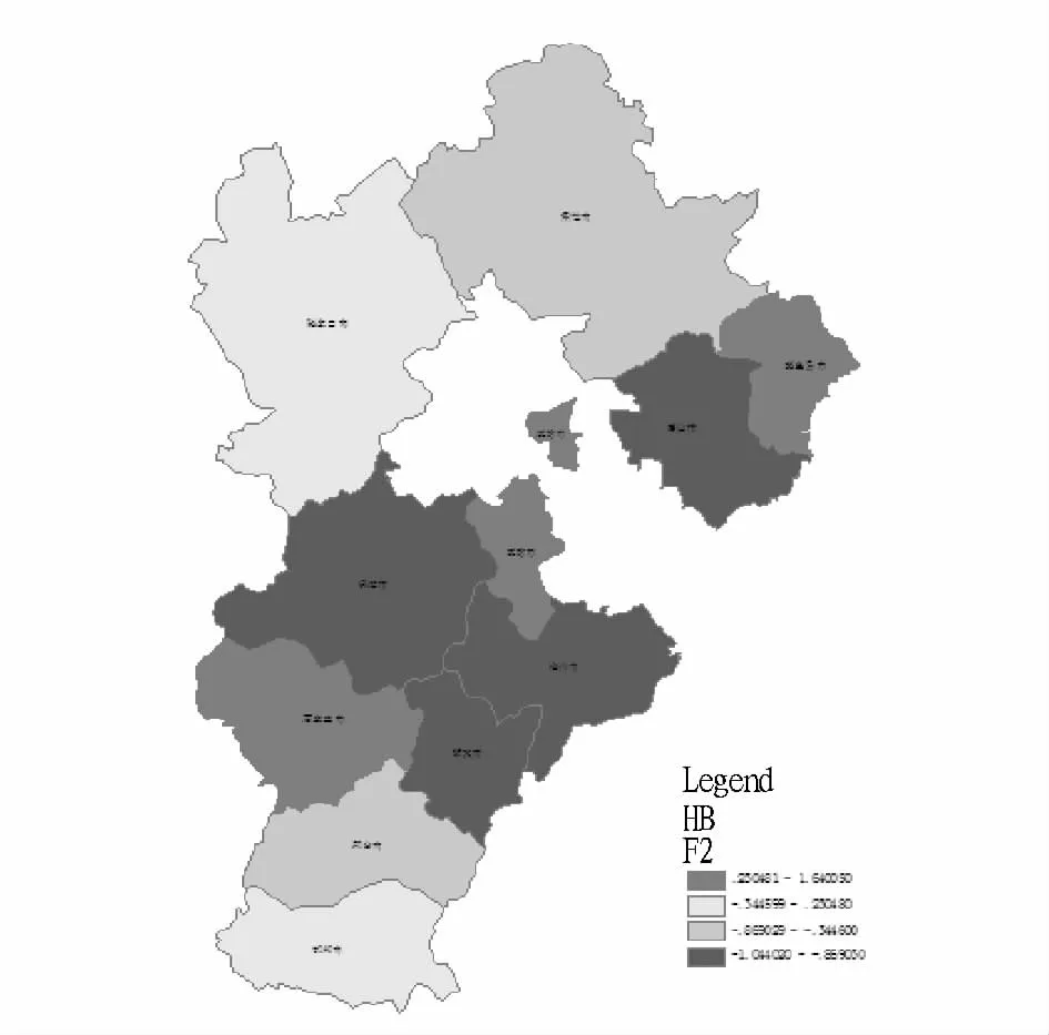
Fig.3 F2 factor regional distribution map
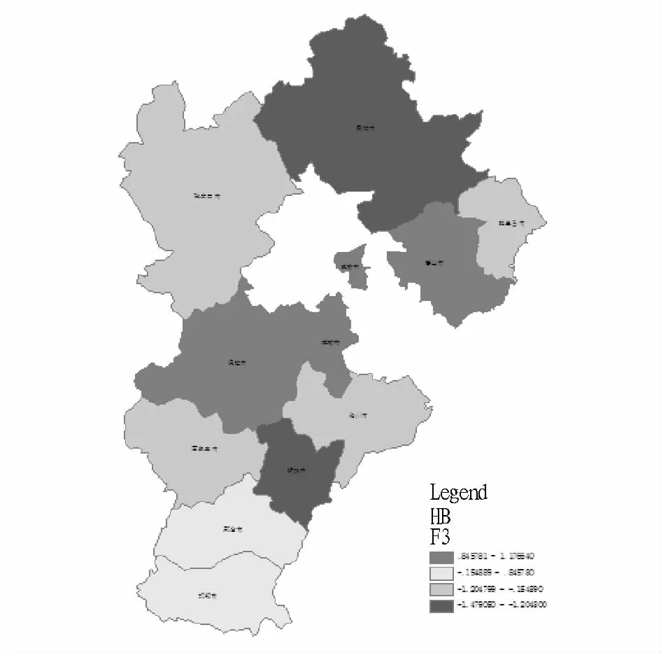
Fig.4 F3 factor regional distribution map
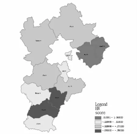
Fig.5 The distribution map of the overall level of urbanization in Hebei Province
GIS spatial analysis can be divided into two levels.One is the simple spatial search and spatial superimposition,and the other is the description and analysis of the spatial pattern.In this paper,we use spatial superimposition and simple spatial pattern description function.The thematic maps on the newly added four attributes are made as follows:
The classification thematic maps use the Natural Breaks(Jenks)method,and the spatial pattern distribution of final composite score is shown in Fig.5.
4 Analysis of evaluation results of the overall level of new urbanization in Hebei Province
Through Table 2-7 and Fig.3-5,the overall level of urbanization in the cities of Hebei Province in 2011 can be clearly seen.We consider the actual situation,history,location and other factors concerning the development of urbanization in the cities,and interpret the above tables and figures.
Qinhuangdao City and Tangshan City get the high composite scores.The social and economic factor scores of the former ranks first,while the social and population factor scores ranks first.Both are coastal cities,with high export-orientated level of economy[10];the level of infrastructure and government's regulatory capacity are strong,and the level of urbanization is high.
The level of urbanization of the second category of cities is general(Shijiazhuang City,Langfang City and Handan City).For these cities,the average score of the three principal factors is relatively close,but except Handan City with the balanced development,Shijiazhuang City has high social and economic factor score,while Langfang City has high economic and population factor score.This is due to the fact that Shijiazhuang is a capital city,affected by government policies,and Langfang is near Beijing,and the Beijing-Tianjin region creates jobs.
The level of development of the third category of cities lags behind in the whole province,and the level of urbanization is low(Chengde City,Zhangjiakou City,Xingtai City and Cangzhou City).The level of urbanization of these cities is low.In addition,the proportion of employed population in the secondary industry,the proportion of employed population in the tertiary industry and the proportion of non-agricultural population in these cities are significantly lower than in the second category of cities.The population urbanization factor is relatively low,and the economic urbanization is relatively backward.
The level of urbanization of the fourth category of cities is very low(Hengshui City and Xingtai City).In terms of the level of economy,health,science and technology,education and culture,these cities are the backward regions in Hebei Province.In these areas,agriculture has a large share,and various urbanization indicators of Hengshui City ranks behind in Hebei Province,with low level of urbanization.The gap between Hengshui City and other cities is very obvious.
The above analysis results indicate that the overall level of urbanization of 11 prefecture-level cities of Hebei Province shows different development models and uneven pace,which is closely related to the location,economic development and national policy of the 11 prefecture-level cities.
5 Recommendations for the development of urbanization in Hebei Province
Hebei Province covers an area of187 700 km2,and it has plains,mountains and basins,so the spatial distribution of the city is greatly influenced and the development of urbanization should suit local circumstances.
(i)Zhangjiakou City and Chengde City are located in the western and northern parts of Hebei Province,with a lot of tableland and mountains.The transportation is not convenient,and the urban development is slow.They play a weak role in driving the development of the surrounding areas.They should innovate upon the ideas for development,and lead the urban transformation and upgrading,to improve the urban facilities,functions,industries and management[1].
(ii)The four cities in the central and southern parts of Hebei Province,Shijiazhuang City,Baoding City,Xingtai City and Handan City,have vast plains,convenient transportation and rich resources.Interaction between the cities should continue to increase.In particular,as the center area,Shijiazhuang City should exert its own strengths to accelerate the cultivation and development of urban agglomerations,and drive the development of surrounding cities[11].
(iii)Qinhuangdao City,Tangshan City,Langfang City and Cangzhou City,as the main cities undertaking industrial transfer,should make use of the coastal advantages to develop the export-oriented economy,and use the advantages of location close to Beijing and Tianjin to promote the urban construction around Beijing.
(iv)For Hengshui City,it should promote economic development and use economic development to drive urbanization;focus on improving the level of city planning and adjusting the administrative divisions.
(v)The development of entire province should be coordinated,and it is necessary to play regional advantages,and promote household registration system management to increase the urbanization rate;adjust the industrial structure and vigorously develop the tertiary industry.
[1]KANG GF,LIU J.The strategic choice of accelerating the process of new urbanization in Bebei Province[J].The Friend of Leaders,2012(3):32-33.(in Chinese).
[2]SHANGGP,ZHANGQJ,LUHW,etal.Land utilization during urbanization process in Hebei Province[M].Beijing:China Land Publishing house,2010.(in Chinese).
[3]National Bureau of Statistics of the People's Republic of China.China statistical yearbook,2011[M].Beijing:China Statistics Press.(in Chinese).
[4]Hebei Yearbook Editing Committee.Hebei yearbook,2011[M].Beijing:China Statistics Press.(in Chinese).
[5]PAN JH,SHIPJ.Spatial difference of coordinative development of urban and rural areas and its mechanism in Gansu Province[J].Arid Land Geography,2011,34(2):355-363.(in Chinese).
[6]HAO HY.Evaluation on the difference of urbanization quality and the promoting measures—Taking the case of10 provinces and cities in eastern areas[J].Reality Only,2012(6):52-55.(in Chinese).
[7]XIANGDJ,LIHW,LIU XY.Applied multivariate statistical analysis[M].Wuhan:China University of Geosciences Press,2011.(in Chinese).
[8]MacEachren AM.How maps work:Representation,visualization and design[M].New York:The Guilford Press.1995.
[9]LIU Y,LIU DQ,MAWJ.GIS approach to urbanization studies[J].Science of Surveying and Mapping,2004,29(5):30-33.(in Chinese).
[10]YAO LL.Comprehensive evaluation of Hebei urbanization[D]s.Shanxi Normal University,2013.(in Chinese).
杂志排行
Asian Agricultural Research的其它文章
- Evaluation of the Agricultural Non-point Source Pollution in Chongqing Based on PSR Model
- Farmers'Willingness to Pay(WTP)for Reducing Agricultural Non-point Source Pollution:Based on the Empirical Analysis of 453 Farmers
- A Study of the Artificial Vegetation Restoration Technology in the Wenchuan Earthquake Area
- Evaluation of the Development of Circular Agriculture in Chongqing City Based on Entropy Method
- Empirical Analysis of the Typical Breeding Pattern of Clam in Hongdao Town and the Preliminary Estimates of Costs and Benefits
- Theory and Practice of Marine Regional Management in China