A Study on Infiltration and Groundwater Development in the Influent Zone of the Perched Lower Yellow River
2013-11-25JingliShaoYaliCuiYunzhangZhao
Jingli Shao Yali Cui Yunzhang Zhao
(1.China University of Geosciences, Beijing 100083;2.Henan Geological Survey, Zhengzhou, 450007)
Abstract:A three-dimension flow model based on the hydrogeological conditions within the influent zone of the Yellow River in Henan Province, Yuanyang, China, was set up using FEFLOW. The interaction of the Yellow River and the groundwater was simulated under various pumping scenarios. For the planned water supply area, simulation results indicate that, within 10 years' pumping at a rate of 4.86×10⁸m3/a, the shallow groundwater flow and infiltration from Yellow River will be stabilized . After 10 years pumping, the infiltration will increase to 3.22×10⁸m3/a and take approximately 70% of the pumping water.
Key Words: influent Zone; perched Lower Yellow River; Groundwater; Simulation Model; Infiltration
1 Introduction
The Yellow River, at its downstream reach in Henan Province, is a typical example of a“suspended river”. The high content of sand and clay in the water colors the water yellow and continuous sedimentation of the sand and clay has raised the river bed a few meters above the ground.In general, the river water is 3 to 5 m higher than the ambient groundwater level. The river acts as a groundwater divide and continuously recharges the groundwater aquifer. Groundwater has become the primary source of water supply, especially under the condition of no-flow and due to the deteriorating water quality of the Yellow River in this study area (Huo et al. 1997). Therefore, it is very important for both groundwater development and water supply to understand the relationship between the water from the Yellow River and groundwater in this area (Lei et al. 2009).
A 3D groundwater flow model was constructed with FEFLOW (Diersch 1996; Chen 2003; Gao et al. 2012) based on the conceptual hydrogeological model along the downstream reach of the Yellow River. The model will provide a tool to quantitatively assess the infiltration changes under different pumping plans, to evaluate various groundwater application scenarios and to provide a theoretical foundation for exploring sustainable water resource usage.
2 Hydrogeology
The influent zone of the Perched Lower Yellow River (IZPLY Fig.1) refers to the area where the groundwater has been altered by the Yellow River,i.e. a certain width and depth of aquifer, which receives recharge from the River (Zhang et al.2001). Based on previous studies (Zhao et al.2003), the width of the influence belt is 5-23 km.The total distribution area along the Yellow River within Henan Province is about 9417.6 km2.From plane view, away from the river, the thickness of the aquifer changes from thick to slightly thin (140 m to 45 m) and grain size from coarse to fine. The thick aquifer distributed along the north bank of the river forms the main aquifer(6.4-23.2 km) with the relatively thinner aquifer distributed along the south bank of the river(5.0-13.7 km). The Yellow River and groundwater in the shallow aquifer are well connected. The Yellow River forms a groundwater divide, where surface water discharges to the two side aquifers.The hydraulic conductivity of the aquifer along the river decreases from upstream to downstream (25 m/d to 5 m/d). Using isotope analysis results(Zhao et al. 2003), the influence depth is found to be within 350m. Due to recharge form the Yellow River and to its large alluvial fan, this area is rich in groundwater and many groundwater well fields are distributed in this zone (Yan et al. 2010).
In vertical section (Fig.2), the Q3and Q4formations consist of the shallow unconfined aquifer, whose thickness ranges from 60-120 m.The Q1and Q2formations form the deeper confined aquifer, which is interlayer with clay, silt and sand, forming 6 to 7 confined aquifer layers.The relatively small water level differences for the several confined aquifers indicate that they are well connected, and thus are assumed to be one confined aquifer in the numerical model. As such the material properties used for the one confined aquifer are equivalent or average values of the smaller aquifers. There is a relatively stable clay layer between the shallow and deeper aquifers,forming a semi-aquifer, with a thickness of about 20-30m. Consequently, the hydraulic connection between the upper and lower aquifer is weakened.
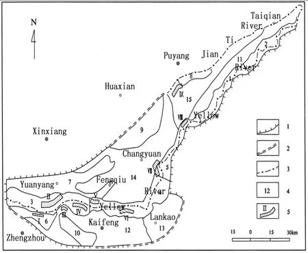
Fig.1 The Boundaries and regions of hydrogeological parameters of the study area
3 Boundary conditions of the Yellow River
The Yellow River and the groundwater near the influent zone are well connected, and the river is a very important recharge source to the groundwater.Therefore, it is critical to correctly describe the relationship between the Yellow River and the groundwater, which directly affects the accuracy and reliability of the numerical model. In general,the river can be treated as an infiltration boundary(first type, second type or combination) according to the actual situation (Anderson and Woessner 1992).
As in a suspended river, surface water recharges the groundwater through a relatively low permeability layer at the bottom of the riverbed.The amount recharged to the groundwater depends on the permeability, thickness and the distribution area of the low permeability layer. In a cross section, the relation between the River and groundwater may be written as:

In which qn-infiltration rate(m/d); hs-surface water hydraulic head(m); h-groundwater hydraulic head(m); M-thickness of ‘colmation' layer (m);Ks-‘colmation' layer hydraulic conductivity at a riverbed(m/d);σ-resistance coefficient, σ=M/Ks(m2/d).
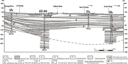
Fig.2 Hydrogeological section across the influent zone of the Perched Lower Yellow River
At the point of the aquifer near the bottom surface of the riverbed, the infiltration rate can be expressed by:

where Kz-hydraulic conductivity of the aquifer at z direction.
Obviously, equation 1 and 2 are equal. That is:

In the numerical model, the river was treated as a combination boundary (Bear 1979). The water level along the River nodes was obtained from hydrology observation stations and one dimensional interpolation according to the time-lag methodology. The coefficient of the river resistance, σ, was determined by model calibration.
4 Numerical modeling of groundwater flow
According to the hydrogeological conditions,the groundwater flow within IZPYR is conceptualized as a heterogeneous, isotropic,three-dimensional groundwater flow. The iso-thermal govening differential equations for the three-dimension flow, together with boundary conditions are:
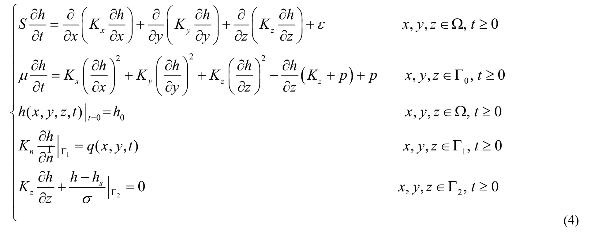
Where Ω-flow domain; Kx、Ky、Kz-hydraulic conductivity along the x,y and z coordinate axes(m/d); S-special storage of confined aquifer;μ-special yield; ε-flux term that accounts for pumping and recharge (1/d); Γ0-top boundary in the domain, as a free surface; p-discharge or recharge rate (1/d) on Γ0; h0- initial hydraulic head (m); Γ1-flux boundary in domain; q-flow components (m/ d) on Γ1;-normal of boundary;Kn-hydraulic conductivity along(m/d);Γ2-combination boundary on the Yellow River.
The flow domain of the model is the IZPYR and the bottom boundary is the bottom of the Q1formation, which is no-flow. The top boundary is the free water table. Through this boundary,vertical exchanges occur, such as, precipitation,irrigation and evaporation. Periphery boundaries are second type boundaries (i.e. a flux or no flow boundary, Fig.1).
FEFLOW was used for the three-dimension flow modeling (Shao et al. 2004). The model grid constructionwas based on the conceptual model,where the geological, hydrogeological and administrative boundaries, groundwater pumping area and the Yellow River recharge boundaries are fully considered and accurately simulated. The total number of nodes in the model is 17,230 and the total number of cells is 26,304. The model was calibrated according to data obtained in year 2000.Through matching the hydraulic head distribution and borehole observation curves, typical aquifer parameters, boundary values and other source/sink terms were optimized and determined. After calibration, the simulated hydraulic head distribution agrees well with the observed head distribution and the change tendency is similar.
5 Groundwater development
An evaluation of groundwater resources was performed with the calibrated numerical model.The average total recharge of the shallow aquifer is about 2,852×106m3/a, of which, precipitation contributes 45~50%, irrigation 25%, and infiltration from the Yellow River 11~13%.
The pumping rate in 2000 was approximately 1,226×106m3, it took about 43% of the recharge.There is some potential to increase the safe yield(Fetter, 2001) by reducing the evaporation and inducing infiltration from the Yellow River.
Similar to a reservoir, the IZPYR is able to provide a long-term supply of water due to its tremendous capacity, wide spatial distribution and depth relatively high hydraulic conductivity, its year-round recharge from Yellow River and relatively good groundwater quality. Based on the hydrogeology and water demands of the area, 9 new large-scale well-fields have been selected,which will increase the water supply to 1,330×103m3/d (486×106m3/a) (Cui 2004). Table 1 shows the names and pumping rates of every planned large-scale well-field. Their positions are labeled on fig.1.

Table1 Pumping Rates in Planning Large-scale Well-fields Unit: 103m3/d
The following study will focus on the Yuanyang well-field and the related changes for flow and water table under pumping conditions.
TheYuanyang water supply aquifer is located on the upper centeral part of the fluvial fan from Handongzhuang to Dabin, over an ancient river course. The aquifer group is composed of formations Q4and Q3, of a depth to about 150 m.There are 4-5 aquifer layers in the group, each approximately 20-40 m deep, totaling a thickness greater than 100 m. The aquifer mainly consists of gravel and sand, with an hydraulic conductivity of 20-50 m/d, specific yield of 120-200 m3/h, and TDS<1g/l. Recharge to the aquifer is mainly from infiltration of the Yellow River and precipitation,some is from canal and irrigation infiltration.Discharge includes evaporation and pumping.
The planned pumping rate for Yuanyang water supply was 400×103m3/d. Two rows of pumping wells were designed parallel to the Yellow River,with each row consisting of 10 wells and each well pumping at 10×103m3/d. In the numerical model,the wells are located at the corresponding nodes.
After 10 years pumping, the simulated depression cone of groundwater tends to be stabilized without apparent influence on the regional flow field (Fig.3). As seen from the observation curve in Fig.4, during the initial pumping period, the water level declined abruptly,and then dropped gradually until it stabilized.After 10 years pumping, drawdown rates in all the observation wells were less than 0.3 m/a. Within 10 years, the maximum drawdown in observation wells was 18.90 m (Obs 2), with an average of 14.58 m. The center drawdown was 23m. The minimum drawdown occurred at observation well#1, which is the nearest well to the Yellow River,at 9.29 m and stabilized at this value only after 6 years' pumping.
The numerical model was used to forecast the groundwater state under the condition of operation of 9 planned large-scale well-fields in 10 years.The results show: (1) the maximum drawdown in the center of a pumping cone is less than 20 m; (2)the groundwater levels tend to be stable within 5-10 years; (3) the regional groundwater flow does not change.
Infiltration from the Yellow River
The infiltration from the Yellow River plays important role on groundwater exploitation. The numerical model indicted that the infiltration rate from the Yellow River will increase with pumping extension on planned large-scale well-fields. Table 2 provides the infiltration rate within 10 years'operation of the well-fields. Before the operation of the planned well fields, the average infiltration from the Yellow River to groundwater is about 315×106m3/a, whereas the infiltration increases to 635×106m3/a after 10 years' pumping. The table shows that about 71.71% of the pumping on planned well fields comes from the Yellow River.
Using the aquifer as the huge adjustable storage for the Yellow River runoff to groundwater recharge and exploitation will enhance the surface water usage, meliorate the water quality and reduce the water treatment costs.
Based on the simulation results, the available water resources will meet the water requirement as planned. Two-thirds of the water is from the Yellow River, which indicates how important the infiltration is to the planned water supply.
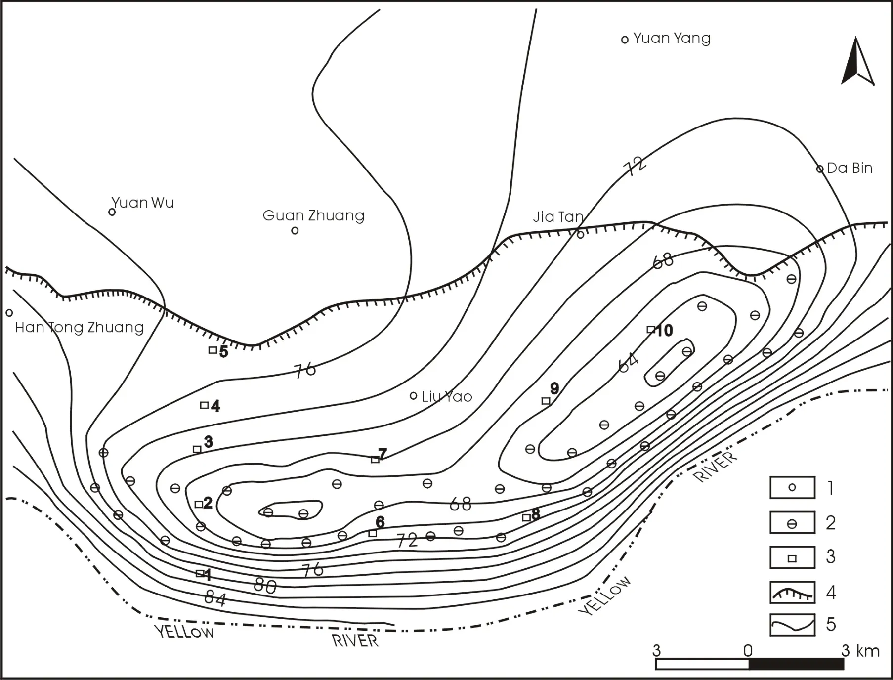
Fig. 3 Groundwater contours of the unconfined aquifer in Yuanyang well-field in ten years
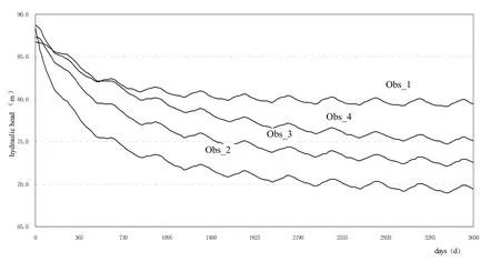
Fig.4 Groundwater drawdown in Yuan Yang well-field
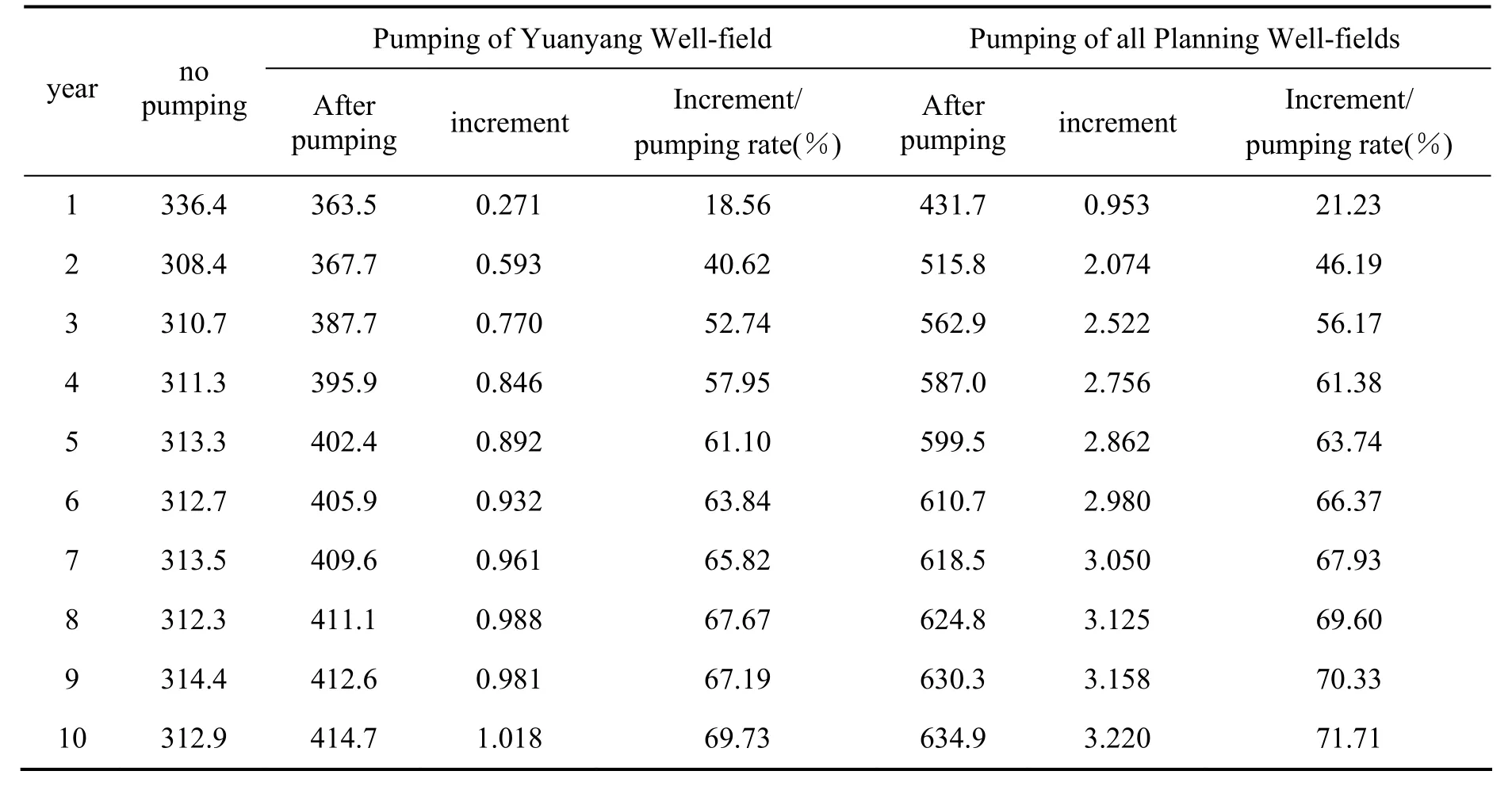
Table 2 Recharge rates from the Yellow River under pumping of planned Well-Fields (106 m3/a)
4 Conclusions
The influent zone of the Perched Lower Yellow River is a huge groundwater reservoir with plentiful recharge from the Yellow River. It is suitable site for the construction of large-scale well-fields. A three dimension groundwater flow model was setup in the IZPYR, in which the Yellow River is dealt with as a combination boundary. The model indicates that: (1) the groundwater level tends to be stable within 5-10 years of pumping; (2) the maximal drawdown in the center of pumping cone is less than 20 m; (3)the regional groundwater flow does not change; (4)about 71.71% of pumping rate on new planning well fields comes from the Yellow River.
Acknowledgements
This work was supported by a grant from the National Basic Research Program of China (973 Program) (No. 2010CB428804).
杂志排行
地下水科学与工程(英文版)的其它文章
- Groundwater Use in the Selenge River Basin, Mongolia
- Groundwater quality Management in China
- Effect of Farmyard Manure Application on Dissolution of Carbonate Rocks and Its Eco-environmental Impact
- Comparison of Three Brine Migration Models in Groudwater
- Organic Contamination of Soil and Goundwater in the Piedimont Plain of the Taihang Mountains
- Stable Isotope Composition of Rainfall, Surface Water and Groundwater along the Yellow River
