Using a Particle Tracking Method to Quantify Groundwater Circulation rates: a Case Study in the Ordos Plateau
2013-08-09LiheYin,HongyunMa,JiaqiuDong等
Abstract:Groundwater is a valuable resource in many areas, and commonly plays a key role in economic development. Therefore, groundwater circulation rates at different depths are key issues for groundwater development and management in the Ordos Plateau. In this study, a particle tracking method was used to quantify circulation rates in the Ordos plateau. The results show that groundwater mainly circulates in shallow groundwater systems up to 400m depth. The results of this study can be used to develop effective programs for groundwater management and development..
Keywords:particle tracking method; groundwater circulation; Ordos Plateau
Introduction
Groundwater is a valuable resource in many areas, and it commonly plays a key role in the economic development of a region (Wood WW and Sanford WE 1995; Harrington GA et al. 2002; Scanlon BR et al. 2006). The Ordos plateau is located in the eastern part of the north-west China. Groundwater is the major water resource in the basin due to undeveloped surface water drainage systems (Hou GC et al. 2006). Due to the abundant mineral resources within the basin, such as coal, natural gas, petroleum and halite etc., one of the largest energy and heavy chemical plants in China is situated there (Yin LH et al. 2011). Recently, water requirements have increased rapidly, with the construction of energy and heavy chemical plants, the development of local industry and agriculture, urbanization, improved quality of life and eco-environment constructions. Therefore, groundwater circulation rates at different depths are key issues for the development and management of groundwater in the Ordos Plateau. In this study, a groundwater flow model was developed, and a particle tracking method was used to quantify circulation rates in the Ordos plateau.
Study Area
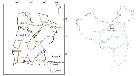
The Ordos Plateau is located in NW China, between 37°10 and 40°30′N and between 106°45′and 110°08′E. The elevation of the Ordos Plateau decreases from 1400-1500 m above sea level (asl) in the central Sishi Ridge to 1,100-1,200 m asl in the eastern, western and northern margins. The Baiyu Mt. at the southern margin has an elevation ranging 1,500–1,800 m asl (Fig. 1).
The climate is generally arid to semi-arid in the Ordos Plateau, The precipitation decreases from 420mm/y in the southeast to 160mm/y in the northwest. Approximately 60%-80% of the rainfall occurs from July to September. The rate of potential evaporation is very high, varying from 2,000 mm to 3,200 mm/a (Yin LH et al. 2009a; Yin LH et al. 2009b; Yin LH et al. 2010).
There are three major rivers in the area, i.e. the Muolin River, the Dosit River and the Wuding River. The first two are ephemeral rivers and the latter is perennial (Fig. 1). These rivers are fed by groundwater. Numerous lakes occur in the study area in response to surface runoff and groundwater discharge, among which 56 have a surface area larger than 1km2. Lakes and wetlands are important features in the study area.

Fig. 1 Location of the Ordos Plateau, China
The geology consists of Cretaceous sandstones of the Bao’an Group, overlain by Tertiary mudstone and Quaternary sediments. The Bao’an Group is further dived into three formations, i.e. the Luohe sandstone (K1l) (oldest), the Huanhe sandstone (K1h) and the Luohaidong Formation (K1lh) (youngest).
Method
Groundwater infiltrates and leaves the model through the upper boundary. The upper boundary therefore includes both constant heads and flux boundaries. The lower boundary of the model is fixed at no-flow as the presence of the impervious Jurassic sandstones. The western boundary is also fixed at no-flow due to contact with impervious metamorphic rocks. On the eastern edge of the model, lateral flow boundaries exist where groundwater flows westward through Quaternary aquifers. The Cretaceous aquifer can be conceptualized as three hydrostratigraphic subunits: the Luohandong formation, Huanghe formation and Luohe formation. The Luohandong formation consists of alternating mudstone and sandstone and exists only in a localized area in the west. The Huanghe formation consists primarily of sandstone, except for an area near the eastern boundary where the Huanghe formation is eroded. The formation ranges from 400 to 600 m in thickness. The Luohe formation contains fine to medium-grained sandstone on the eastern side, and fine-grained sandstone imbedded with mudstone in the west. The thickness of Luohe formation is relatively uniform, at approximately 200 m. The uppermost stratigraphic layer is formed of Cenozoic unconsolidated sediments, ranging from 10 to 100 m in total thickness.
To describe the geology of the area in the model, a finite-difference grid consisting of 600 columns and 125 layers was used. The grid spacing is 400 m in the horizontal direction and 10 m in the vertical direction. The distribution of horizontal hydraulic conductivities for the different hydrostratigraphic units was assigned on the basis of pumping tests and facies analysis.
The particle tracking method is widely used to determine the protection zones of well fields (Johnson, er al. 1994; Born et al. 1988; Wang JS et al. 2004). In this study, it was used to calculate the circulation depth of groundwater. The specific yield is 0.15 estimated from pumping tests. Firstly, the velocity field was calculated based on the simulated groundwater head distribution. Then, the recharge rate was calculated using Darcy's Law. Particles were placed in the upper most active cells representing the recharge rate assigned to the cell and moved. When the direction of the particle changed, the location was recorded and used to determine the circulation depth.
Results
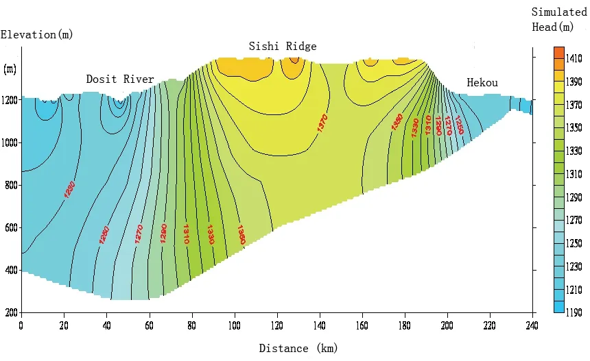
In the centre of the section, groundwater head varies from 1,350 m to 1,400 m, forming a 100 km-wide groundwater
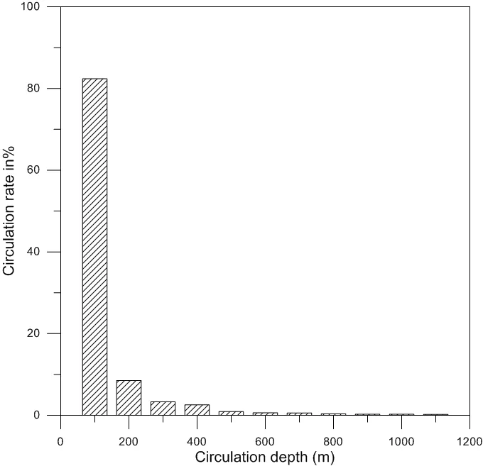
Divide (Fig. 2). Simulated groundwater head decreases eastward and westward from the centre. A discharge zone is located in the area bound by the Sishili Ridge and Wushen County. On the eastern side, groundwater flow is dominated by horizontal flow due to uplift of the imperious lower boundary. In general, groundwater flows are control by topography and forms a multi-level system. Fig. 3 shows that 90% of groundwater circulates at depths shallower than 400 m when modeled with the particle tracking methodology.

Fig.2 simulated groundwater head

Fig. 3 Percentage of circulation rate in depth
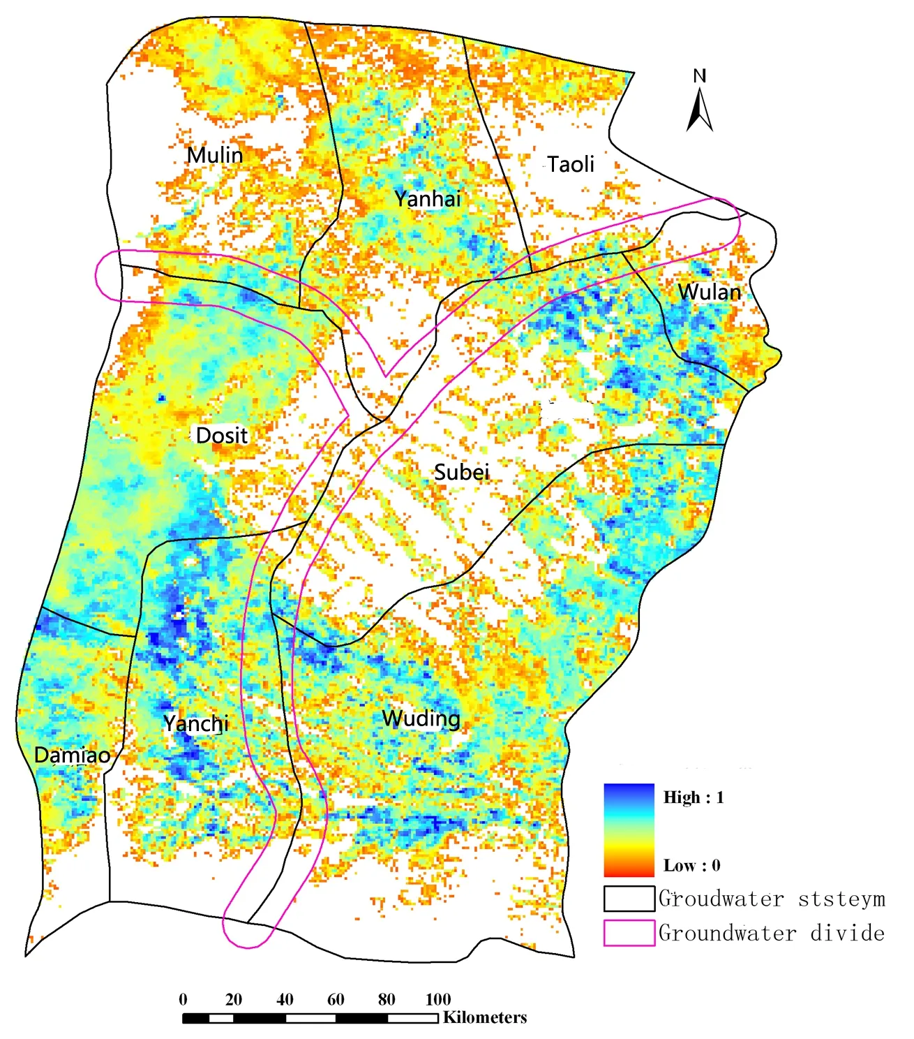
Fig. 4 shows the Coefficient of precipitation infiltration based on the study of Yin et al. (2011). Groundwater deeper than 400 m mainly originates in the groundwater divide. Groundwater recharge (calculated from Figure 4) in these areas is about 10% of the total recharge- consistent with the result of the particle tracking.

Fig. 4 Coefficient of precipitation infiltration in the Ordos Plateau
Conclusions
Groundwater is a valuable resource in many areas, and it commonly plays a key role in the economic development of a region. Therefore, groundwater circulation rates at various depths are key issues for the development and management of groundwater in the Ordos Plateau. In this study, a particle tracking method was used to quantify how groundwater circulation rates vary with depth. The results show that approximately 90% of groundwater circulates at depths shallower than 400m.
