Study on the Infrastructure for Spatial Information in Germany
2013-02-19QIURuqiongLIBingZHENGLina
QIU Ruqiong, LI Bing, ZHENG Lina
(1.Hubei Geomatics Information Center, Wuhan 430074,China)
1 Introduction
The spatial data infrastructure of Germany (GDI-DE)is a common project of the federation, the 16 federal states and the municipalities. The overall goal is to make spatial data existing in numerous institutions across different administrative levels available for decision-making processes of all kinds in public administration, business,science and society.
So far, utilizing standards referenced in a concept for an architecture for GDI-DE and recently strongly supported by the INSPIRE directive, many spatial datasets have been described with metadata and made available through spatial data services (primarily WMS, also WFS). Metadata that has been created has been made available via different catalogue services, all of them feeding the central search component for metadata that is being build up for GDIDE (Geodatenkatalog-DE), which will also serve as central discovery service for INSPIRE.
Also, a wide range of different applications (e.g.geoportals) have been built up, for instance, provide discovery functionality for spatial data and services and generally make use of them. However, they either focus on a given administrative unit (e.g. federal state, municipality)or a specif ic domain (e.g. environment). Thus, at the time of writing, there is a lack of an application that provides insight into the entirety of spatial data sets and services that have already been described and/or made available according to the GDI-DE architecture by numerous institutions across different administrative levels in Germany. In the absence of such an application (e.g.geoportal), there is no way to easily gather which spatial data and services are already available, or put differently,what GDI-DE currently consists of. In this situation,progress made in making spatial data available may not be readily conceived by potential users, which is very likely to slow it down. In turn, an improvement of transparency and user awareness is likely to reveal potential benef its and speed up progress.
This is why a common Geoportal-DE is needed and under development for GDI-DE. This paper will report about this work in progress. A rapid prototype will be presented and technical as well as organizational issues that have been encountered during development will be discussed.
2 Introduction of the GDI-DE
The structure of government in Germany has three distinct levels of public authority:local, regional and national, all of which are generators and holders of public information. This structure has an inf luence on the development of the German SDI. The development of GDI-DE as a public infrastructure began in 1998 within the Federal government. According to a decision of the CEOs of the public administrations on federal, state and municipal levels GDI-DE became a cooperative project steered since 2005 by a steering committee (so-called LG GDI-DE) which is made up of representatives from the federal government, the federal states and the communal head associations. The overall goal of which is to make spatial data existing in numerous institutions across different administrative levels available for decisionmaking processes of all kinds in public administration,business, science and society. While at the beginning the development was driven only by national needs it is now guided by the EU INSPIRE Directive put in force on 17 May 2007. Furthermore, the development of GDI-DE is also influenced by the EU project Global Monitoring for Environment and Security (GMES).
2.1 Trans-national and multi-level organizations of the GDI-DE
Within the scope of the GDI-DE a common organizational structure has been established by the Federal Government, the States and the municipalities, comprising a Steering Committee and a Coordination Centre. Further,an advisory board with representatives of private enterprise(GIW Commission) was set up (Figure 1).
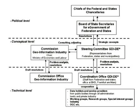
Figure 1 Organisational structure of the GDI-DE
The GDI-DE is an open process, whereby all documents,agreements, and infrastructure elements of the private sector, science and the public will be made available for general consultation (www.gdi de.org). Collaboration with industry is concentrated in projects run in cooperation with business associations, and the “Committee for Geobusiness(GIW)” and its off ice, which is located within the Federal Ministry of Economics and Technology(www.geobusiness.org). In these projects, the requirements of the INSPIRE Directive are taken into account. The GIW is a permanent guest member of the LG GDI-DE contributing additional user requirements to the ongoing development of the GDIDE.
2.2 Objectives and tasks of the GDI-DE
GDI-DE consists of spatial data, metadata, spatial data services and networks, including network technologies.Besides the technical components required to create a GDI organizational framework conditions:Laying legal norms e.g.determine the basis for the provision of spatial data, agreements governing access to and use of spatial data and services between providers and users, and coordination and monitoring mechanisms to ensure that measures actual functioning of the GDI. The basis of interoperability, standards and standards(specif ications) on the basis of the combination and interaction of various components which make use of one common spatial data and services are possible.
The construction of the GDI-DE is aimed at improving the supply and use of spatial data held decentrally by various administrative branches and levels of government(federal, state and municipal governments). This is linked to the demand to simplify information, communication and transaction processes—both within the administrative structures and between administrations and individual citizens, society, the private sector and scientific stakeholders. The GDI-DE can be seen as a public infrastructure of federal, state and local authorities based on interoperable spatial data and services. Hence, the GDIDE constitutes an important pillar of the E-Government in Germany. The purpose and scope of the GDI-DE extends beyond implementation of the INSPIRE Directive by taking into account national requirements for a spatial data infrastructure as well.
3 Architecture of the GDI-DE
Within the frame of the GDI-DE, in practice organisational and technical regulations on geodata, metadata and Web-based geodata services as well as agreements concerning concepts of data utilisation and accounting are elaborated and adopted. The architecture concept of the GDI-DE resolved by the Federal Government, the State and the Leading Community Associations constitutes in this context an important milestone within the framework of e-government in Germany.
3.1 Principles and goals of the GDI-DE Architecture
The GDI-DE Architecture is based on established national and international norms and standards from overall information technology and the geoinformation domain.The GDI-DE Architecture is generally applicable at all levels of public administration. The technical standards are also suitable for adoption by business, science and other societal fields. Based on these principles the following long-term objectives are essentially:
1) Interoperability by adhering to open standards(independent of vendors and products).
2) Portability by recommending and using widely accepted standards.
3) Extensibility by adhering to principles of Service-Oriented Architectures (SOA), extensible with additional functions.
4) Availability and performance by considering user and performance requirements as well as the legal framework.
5) Testability by verifying the conformity of components with standards applying software specif ically developed for that purpose, open and available for everybody.
6) Scalability by extending and distributing individual components, according to growing demand and load.
7) Security by utilizing security architectures in order to allow for trustful, sustainable and reliable use of spatial data and services.
3.2 Technical design of the GDI-DE Architecture
The resulting from the described application architecture pattern of GDI-DE (Figure 2) is a Service-Oriented Architecture (SOA). The concept of SOA is based on the principle of using the present distributed resources(data and functionality), which are standardized interfaces(services) provided interoperability.
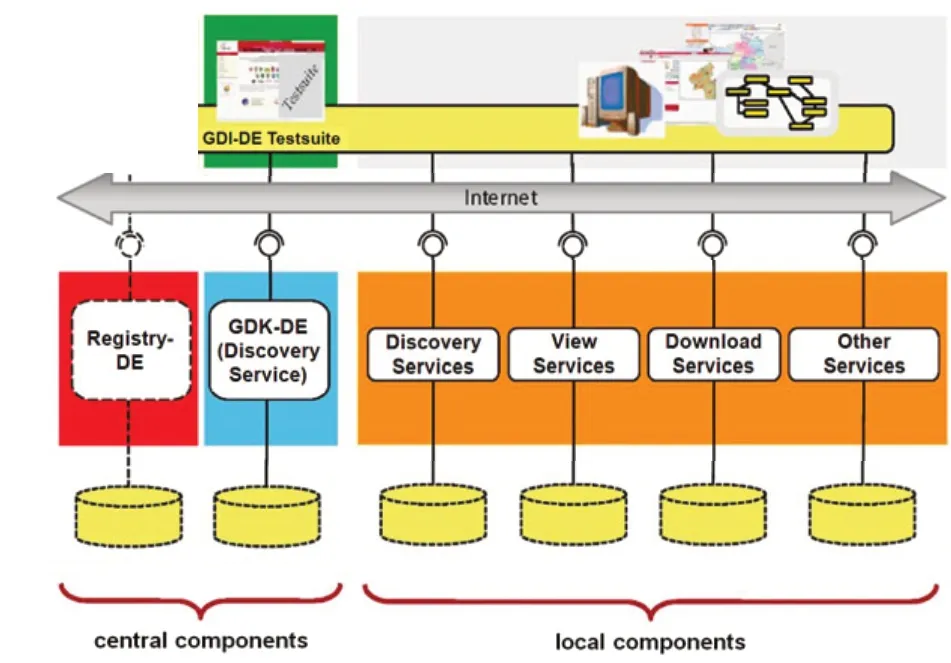
Figure 2 Architecture of the GDI-DE
From the view of implementation the spatial data infrastructure is not in a single project, but will be implemented through a variety of complementary projects,involving in particular the holding and geodata-using agencies involved.
An essential requirement of the architecture is to allow users and data providers that are not known in advance,can interact with each other. To enable this presented to the Publish-Find-Bind pattern, the following operating components should be in the GDI-DE run centrally for all partners of the GDI-DE:
1) Geoportal-DE, a site that gives users easy retrieval and use the options available in the GDI-DE geospatial data, spatial data services and other IT-based applications for spatial data and provides important information.
2) Geocatalog-DE, a search service that allows all available in the GDI-DE geodata and services can be found.
3) Registry-DE, an information system that serves the management and technical support cross-cutting approaches.
4) GDI-DE testsuite, a test environment to verify the conformity of spatial data services.
A local implementation of the architecture is carried through the provision of search services, view services,download services and other spatial data services using the recommended standards.
4 Implementation Plan of the GDI-DE
Based on the technical concepts of the GDI-DE Architecture, procedures and instruments shall be implemented on all operational levels of GDI-DE (Figure 3).
The main tasks are:

Figure 3 GDI-DE implementation plan
1) Administration. To cope with organizational challenges a detailed cross administrative operating model will be established. The operating model will cover already existing and future business cases and will focus on those administrative issues which are crucial for realizing vertical integration of service offers.
2) GDI-DE specification program. The specification program supports the maintenance of the technical architecture GDI-DE. Future requirements either from the ongoing INSPIRE process or from sub-national SDIs will be carefully integrated without affecting recent implementations.
3) Metadata management. To improve the network of Germany's major catalogue services and the management of its metadata a pilot project has been initiated:Geocatalog-DE. The aim is to link distributed catalogue services, e.g.hosted on the federal or municipality level—in a way that distributed metadata can be quickly accessed from a single entry point. In particular interoperability and performance issues are subject of this project and different methods like harvesting, caching or cascading will be evaluated.
4) Vertical integration. Consistent license management is an important component for cooperative data and service sharing. In addition to this, efficient data and service sharing also requires distinct keywords and related descriptions. With a GDI-DE pilot project called“Registry-DE” it is planned to setup a central registry service to manage and provide consistent SDI-information(e.g. parameters of coordinate systems, units of measure,def inition of terms etc).
5) Spatial data offerings. In order to increase the number and quality of spatial data offerings, it is planned to provide recommendations concerning the identif ication of key datasets in public administration in Germany.The recommendation could define key datasets by the following indicators:①The dataset is required by public administrations to provide services according to their legal mandate.②The dataset is of interest for a modern administration.③The dataset is of general economic interest.④The dataset is of research interest.
A key instrument to coordinate the GDI-DE structure is the adjustment of GDI-DE issues in working groups.Working groups are usually formed by delegates from the public sector in cooperation with private companies.Another key instrument for the implementation of GDI-DE is the set up of pilot projects. Besides the already mentioned projects “Registry GDI-DE” and“Geodatenkatalog-DE”there is another important pilot project “Protected Area Sites”. In this project distributed map services across several administrative areas and levels of detail have been connected to produce a joint map of protected areas over Germany. All contributing geo-resources remain distributed,but on request it is possible to compose a joint harmonised map. In a first phase the system had been exemplarily implemented by a selected number of partners in Germany.On the second phase, completed in 2008, the goal of universal provision of protected information for Germany has been largely achieved. In addition, concepts have been,for example in the areas of presentation, common attribute information, and the use of a central registry and the provision of WFS services.
Parallel to the GDI-DE development, which is a coordinated development of the federation and the federal states with representation of the local level (municipalities),SDI developments have taken place in the federal states starting in the late 90s. These developments are now strongly related to the SDI developments of the GDI-DE.
5 Enlightenment and reference of the GDI-DE
In May 2000, the State Bureau of Surveying and Mapping formally proposed the idea of building the national digital geospatial framework, and made it as overall objective and major task of the future surveying career development. As an important starting point for digital geospatial framework construction, more than 150 cities have started the pilot and promote the construction of digital geospatial framework in recent years. These cities not only accumulated a large number of spatial data but also get valuable experience in the standard of information using, management mechanisms and so on. However, we still face many problems and challenges. By researching and analyzing on the German spatial information infrastructure design and implementation process, we can get much enlightenment and reference summarized to the following aspects:
1) Focusing on the program which makes the planning have the force of law and operability. The construction and operation of a cross-administrative spatial data infrastructure in a federal state such as the Federal Republic of Germany requires a high degree of coordination. Germany makes use of the legal authority and seriousness in order to provide protection systems and measurements for the implement of the GDI-DE.
2) Coordinating multi-channel information resources to meet the needs. Spatial information sharing is not one thing for a small number of professional or trade, but more than one or two departments will be able to solve this problem. It involves many stakeholders and user groups,not just the public sector, also needs the participation of the individual institutions and the whole society.
3) Clearing tasks and progress in order to facilitate its implementation. The projectors need develop appropriate guidelines, management practices, completing deadline and the division of labor in according to the objectives and requirements.
4) Focusing on the construction of geospatial data resources. The main body of the NSDI is to build spatial dataset which are consistent, integrated, continuously updated, easy to find and evaluate under the guidance of the relevant technical standard specif ications.
[1]http://www.gdi-de.org/inspire
[2]http://www.geoportal.de/DE/Geoportal/geoportal.html?lang=de
[3]The National Spatial Data Base of Spatial Data Infrastructure in Germany Version 1.0 [R].2009.11.4
[4]Architecture of Spatial Data Infrastructure in Germany Version 2.0[R].2010.9.9
[5]The National Spatial Data Base of Spatial Data Infrastructure in Germany Version 1.0 [R].2009.11.4
[6]Spatial Data Infrastructures in Germany: State of play[R]. 2010
[7]QIU Ruqiong. Overall design of Hubei Geomtics Public Service Platform [J].Geospatial Information, 2010(6):5-7